Table of Contents
Advertisement
Available languages
Available languages
Quick Links
Section 1 – ORIENTATION (Brunton Eclipse 8097)
Section 2 – MAGNETIC DECLINATION
Section 3 – FIELD BEARING
Section 4 – DIRECTION OF TRAVEL
Section 5 – TOPOGRAPHIC MAP
Section 6 – MAP BEARING (Map, Compass & Protractor Alignment) 6 - 8
Section 7 – TRIANGULATION
Section 8 – BACK BEARING
Section 9 – COORDINATE POSITIONING (UTM Grid)
Section 10 – CLIP + ANIMAL ALERT / RESCUE WHISTLE
Section 11 – POCKET / MAP CLIP
Section 12 – ADDITIONAL INFORMATION
Section 13 – ECLIPSE 8097 SPECIFICATIONS
ECLIPSE 8097
INSTRUCTION MANUAL
Page(s): 1 - 2
i
2 - 4
4 - 5
5
5 - 6
8 - 10
10
10 - 12
13
13
13
13
Advertisement
Table of Contents

Related Manuals for Brunton Eclipse 8097


Summary of Contents for Brunton Eclipse 8097
- Page 1 Section 1 – ORIENTATION (Brunton Eclipse 8097) Section 2 – MAGNETIC DECLINATION Section 3 – FIELD BEARING Section 4 – DIRECTION OF TRAVEL Section 5 – TOPOGRAPHIC MAP Section 6 – MAP BEARING (Map, Compass & Protractor Alignment) 6 - 8 Section 7 –...
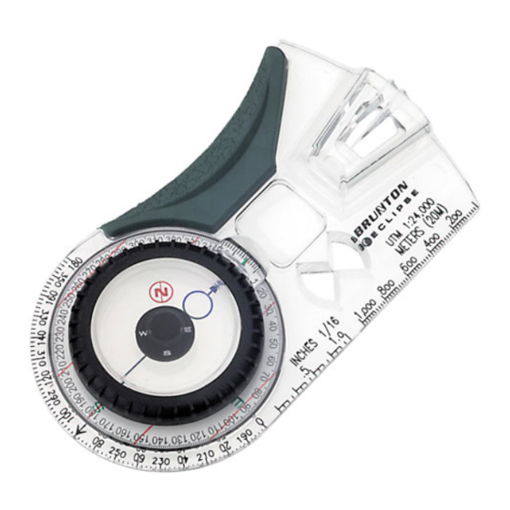
- Page 2 1 -- Orientation: Brunton Eclipse 8097 The Eclipse 8097 compass is a sighting instrument which uses the Earth’s magnetic field to display a bearing (direction) in degrees, with respect to true or magnetic north. The orientation section provides a description of the important Eclipse 8097 parts. A detailed description of 8097 operation is provided throughout the instruction manual.
-
Page 3: Magnetic Declination
With a partner, use the double prism alignment system to sight an object or destination. 1.9 Clip + Animal Alert / Rescue Whistle (Fig 1) The lanyard clip provides hands-free storage of the 8097 around your neck, wrist, etc. Also, use the whistle for a rescue signal or animal alert. -
Page 4: Field Bearing
Figure 5 3 – Field Bearing For the best accuracy, have a partner stand directly above the Eclipse 8097 and adjust the azimuth ring, while you sight an object through the double prism. 3.1 Forward Sighting With Partner 1. -
Page 5: Direction Of Travel
Figure 7 1. Adjust 8097 for magnetic declination. 2. Rotate azimuth ring until set at known field bearing. (Fig 8) 3. Pivot your body until vial displays “circle over circle”. (Figs 9 & 10) Figure 9 Figure 10 4. Sight distant object or destination at field bearing, and travel to it. -
Page 6: Map Bearing
Whether in the field or at home, it is possible to determine a bearing from one position to another, directly from a map. The 8097 provides three methods of finding map bearings - map, compass and protractor alignment methods. 6.1 Map Alignment Map alignment is the most accurate method. - Page 7 6. Rotate azimuth ring until blue orienting circle points to the map’s true north. (Fig 18) · Align blue line in vial and lines on graduated dial with drawn true north-south lines. 7. Read bearing. 6.3 Protractor And Centering Template Use the centering template and the protractor to determine a map bearing.
- Page 8 1. Adjust for magnetic declination. 2. Find three prominent landmarks in the field. 3. Orient map to true north. See section 6.1, Map Alignment, for help. 4. Find and mark all three landmarks with an ‘X’, and label them ‘1’, ‘2’ and ‘3’. (Fig 22) Figure 22 5.
-
Page 9: Back Bearing
direction while bearings on a map are determined. With magnetic declination set at 0°, and compass set at sighted bearing, rotate compass about position until the dial and the blue line in the vial are aligned with the map’s true north-south lines. Then, draw bearing lines. -
Page 10: Additional Information
11 – Pocket / Map Clip An additional feature of the Eclipse 8097 is the pocket / map clip that fits into the same terminal as the lanyard clip. Clip compass to shirts, pant pockets, or maps for orienteering or route determina- tion. - Page 11 Section 10 – AGRAFE ET SIFFLET DE SECOURS OU D’ALERTE CONTRE LES ANIMAUX Section 11 – AGRAFE POUR POCHE/CARTE Section 12 – RENSEIGNEMENTS COMPLÉMENTAIRES Section 13 – SPÉCIFICATIONS TECHNIQUES DU MODÈLE ECLIPSE 8097 ECLIPSE 8097 MANUEL D’INSTRUCTIONS 17 - 18...
- Page 12 1 – ORIENTATION : Brunton Eclipse 8097 La boussole Eclipse 8097 est un instrument de visée qui permet de calculer un relèvement (direc- tion) en degrés par rapport au nord magnétique ou géographique. Cette section fournit une description des principales composantes de la boussole. Les autres sec- tions de ce manuel présentent une description détaillée du fonctionnement du modèle Eclipse.
-
Page 13: Déclinaison Magnétique
Pour obtenir les résultats les plus précis possible, l’aide d’un partenaire est requise. Le partenaire doit se tenir directement au-dessus de la boussole 8097 et ajuster le cadran azimutal pendant que vous visez un objet ou point de repère à travers le double prisme. -
Page 14: Ligne De Marche
Que vous soyez à la maison ou sur le terrain, il est possible de calculer le relèvement d’une position à une autre directement sur la carte. La boussole Eclipse 8097 offre trois méthodes pour déterminer les relèvements sur carte : alignement sur carte, alignement de la boussole et rappor- teur d’angles. -
Page 15: Relèvement Inverse
3. Sur la carte, marquez une position de départ par un « point » et une destination par un « X ». 4. Tracez une ligne reliant ces deux coordonnées. 5. Disposez la base transparente à côté de la ligne de relèvement (Figure 17). Figure 17 - p. - Page 16 180º. Gardez tous les relèvements entre 0º et 360º puis suivez les instructions suivantes pour cal- culer le relèvement inverse. Calcul du relèvement inverse 1. Si le relèvement est de 0º et 180º, ajoutez 180º. 2. Si le relèvement est de 181º et 360º, soustrayez 180º. 9 –...
- Page 17 10- Agrafe et sifflet de secours ou d’alerte contre les animaux Un sifflet de secours ou d’alerte contre les animaux est inclus avec la boussole Eclipse 8097. Vous pouvez retirer le sifflet en appuyant sur le verrou de retenue au bas du sifflet puis en tirant.
Need help?
Do you have a question about the Eclipse 8097 and is the answer not in the manual?
Questions and answers