Advertisement
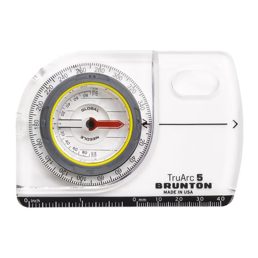
Parts of the Compass

- Azimuth ring w/ 2° graduations (TruArc 10, 15, 20 - 1° graduations)
- Orienting Needle Outline
- Global Needle
- Rotating Dial
- Bearing Index line
- Direction of Travel Arrow
- Map Magnifier
- Inch/mm Scale
- Liquid Filled Vial for Smoother Needle Movement
- Ergonomic Base Plate
- Declination Adjustment Scale
- Declination Adjustment Index Line
- On the Map Meridian Lines
(models 5, 7, 10, 15, and 20 only) - Lanyard lash point
- Protective Mirror Cover
(models 7, 15, and 20 only)
Magnetic Declination
The difference between True North and Magnetic North (which attracts your compass needle) varies depending on your location on the globe. To find your current declination visit NOAA's online declination calculator here: www.ngdc.noaa.gov/geomagmodels/Declination.jsp
Your Brunton TruArc Compass features tool-free declination adjustment. To adjust, place your thumb in the center of the liquid filled vial, then pinch the vial with your fore-finger on the bottom through opening in the center of the vial base. Hold the rotating dial (part no 4 above) still with you other hand, and then twist the liquid filled vial within the outer dial (fig 1). Adjust to the appropriate declination setting according to your location using the red hash mark at the tail of your magnetized needle. When complete, the compass will automatically compensate for declination.

For example, if your current declination is 20 degrees West (or 20°W) the compass should adjust 20 degrees toward the West to compensate. The figure here shows the factory setting at zero declination, and then compensated according the declination scale (Fig 2a & 2b)

Finding your heading/bearing without a map
- Select a visible landmark along the route you wish to travel such as a rock formation or mountain top. With the compass held level, point the direction of travel arrow on the compass base plate at the landmark. (Fig 3a) If you're using a mirrored compass, center the landmark in the sighting window, and position the mirror so that a top view of the compass dial is visible in the reflection.
![]()

- Rotate the dial until the red outline aligns with the north-seeking needle. Read your heading/ bearing at the index line. (Fig 3b) When using a mirrored compass, keep your landmark centered in the sighting window, and align the needle with the orienting arrow using the reflection shown in the mirror.
![]()
- Keep the needle aligned with the red orienteeringoutline as you travel to your landmark. Repeat procedure until your destination is reached.

If you know your bearing
- If you have been given a bearing in degrees to follow, turn the dial so that the index line aligns with the correct bearing degree number. Hold the compass level with the direction of travel arrow pointed straight ahead.
- Turn your body until the needle is aligned with the red needle outline. You now face your correct direction of travel (fig 4)
![]()
- Pick out a landmark along your direction of travel and move towards it, checking periodically that your needle and red needle outline are aligned. Repeat this procedure until your destination is reached.

Finding your way using a map
- Place compass on map with the straight edge along your desired direction of travel. Make sure that the direction of travel arrow points toward your destination.
- Keeping the compass in place along your desired direction of travel, reposition the map until red needle outline and the needle are aligned (fig 5a & 5b).

- In the landscape, pick out a landmark along your direction of travel and move towards it, checking periodically that your needle and red needle outline are aligned. Repeat this procedure until your destination is reached.

Finding your position on a map (triangulation)
- If your location is unknown, identify (3) three landmarks that can be seen in the landscape as well as on the map. These would generally be obvious rock formations, river bends or mountain tops.
- Point the direction of travel at landmark #1 and find the bearing per instructions above.
- Place your compass on the map, with one corner of the straight edge on Landmark #1. Rotate the base plate of the compass so that the needle and the red needle outline align.


- Draw a line along the straight edge of the compass base plate, extending it as needed (fig 6).
![]()
- Repeat this process for landmark #2 and again for #3.
- The triangle formed by the three lines crossing will approximate your position on the map.

Use of inclinometer to measure vertical height (models 7, 15, and 20 only)
- Rotate dial until West (270°) is at the index line.
- Turn the compass on its side with mirror open out to the left. Position the mirror until you can see the reflection of the graduated dial.
- Sight to the top of the tree or rock formation you are measuring through the mirror's sighting window.
- In the reflection, read the incline where the red clinometer arrow points at declination scale.
- Use the sloping ground illustration and tangent table to calculate vertical height (fig 7)


NOTE:
Never expose your compass to extreme temperatures exceeding 140°F or below -30°F. Remember that your compass functions using a magnetic field. Prolonged exposure to electronics, stereo speakers, knives, metals or other magnets (anything with a magnetic field) can cause your compass to lose or reverse polarity. Always check the functionality of the compass before relying on it in the field. Brunton recommends avoiding contact with insect repellents or sunscreens containing DEET. These can damage clarity of the compass and wear off necessary scales and markings.
7088 Winchester Circle
Boulder, CO 80301
www.brunton.com
info@bruntongroup.com

Documents / Resources
References
Download manual
Here you can download full pdf version of manual, it may contain additional safety instructions, warranty information, FCC rules, etc.
Advertisement


Need help?
Do you have a question about the TruArc and is the answer not in the manual?
Questions and answers