Table of Contents
Advertisement
Quick Links
Advertisement
Table of Contents

Related Manuals for Garmin GPSMAP 86


Summary of Contents for Garmin GPSMAP 86
- Page 1 GPSMAP ® Owner’s Manual...
- Page 2 © 2019 Garmin Ltd. or its subsidiaries All rights reserved. Under the copyright laws, this manual may not be copied, in whole or in part, without the written consent of Garmin. Garmin reserves the right to change or improve its products and to make changes in the content of this manual without obligation to notify any person or organization of such changes or improvements.
-
Page 3: Charging The Device
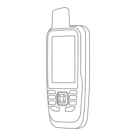
Introduction Keys WARNING See the Important Safety and Product Information guide in the product box for product warnings and other important information. GPSMAP 86s/sc Device Overview FIND Select to open the search menu. MARK Select to save your current location as a waypoint. QUIT Select to cancel or return to the previous menu or page. -
Page 4: Saving Energy While Charging The Device
SMS phone number, an email address, or another device with inReach technology. Each message you send includes your location details. NOTE: A preset message includes predefined text with predetermined recipients, and you must set it up on the Garmin Explore website. ™... - Page 5 Select a conversation. customer, you can specify the interval when you are stationary. Select a message. Select the information tab. Navigating to a Message Location During an emergency, you can contact the GEOS International Emergency Rescue Coordination Center (IERCC) to request When you receive a message from another device with inReach help.
-
Page 6: Testing The Device
From the map, move the cursor to a location. Select MENU > Measure Distance. You can sync data from your Garmin Explore account to your Select additional locations on the map. device using the Garmin Explore app. After you make edits to... -
Page 7: Trip Computer
Follow to your destination. Display: Sets the type of directional heading shown on the compass. Course Pointer North Reference: Sets the north reference used on the The course pointer is most useful when you are navigating on compass. water or where there are no major obstacles in your path. It can Go To Line (Pointer): Sets the behavior of the pointer that also help you avoid hazards near the course, such as shoals or appears on the map. -
Page 8: Connected Feature Requirements
You can invite contacts by sending an inReach • If you are using an Android smartphone, from the Garmin message from the field. This feature allows your contacts to view your live data on a MapShare tracking page using your Connect app, select Settings >... -
Page 9: Connect Iq Features
Controlling and Viewing Compatible Marine Devices You can add a .gpx file that contains waypoints by transferring You can use the GPSMAP 86 device to control a compatible the file to the GPX folder (Transferring Files to Your Device, autopilot, control a compatible FUSION ®... - Page 10 Waypoint Averaging Select MENU > Reposition Here. You can refine a waypoint location for more accuracy. When The waypoint location changes to your current location. averaging, the device takes several readings at the same location and uses the average value to provide more accuracy. Routes Select Waypoint Manager.
-
Page 11: Recording Settings
Weather GPX Auto Archive: Sets an automatic archive method to organize your recordings. Recordings are saved and cleared Active Weather: While your GPSMAP 86 device is connected automatically. to your smartphone or to a Wi‑Fi network and has an active Trip Recording: Sets a trip recording option. -
Page 12: Data Use And History
NOTE: You cannot delete the My Location forecast. Select MENU > Delete. Data Use and History Viewing an Active Weather Forecast While your GPSMAP 86 device is connected to your Viewing Plan Details smartphone or to a Wi‑Fi network and has an active internet Select inReach Utilities. -
Page 13: Birdseye Imagery
If necessary, create an account. Flashlight: Turns on the flashlight (Using the Flashlight, page 13). Sign in. XERO Locations: Displays laser location information when you have a Xero bow sight paired with your GPSMAP 86 device. ® Main Menu Tools... - Page 14 Cache Size. A chirp is a small Garmin accessory that is programmed and left • To filter by Unattempted, Did Not Find, or Found in a geocache. You can use your device to find a chirp in a geocaches, select Status.
-
Page 15: Customizing The Device
Turn on your VIRB camera. Select Setup > Geocaching > Geocaching Live > Remove Live Data. On your GPSMAP 86 device, select VIRB Remote. Live geocaching data is removed from the device and no Wait while the device connects to your VIRB camera. -
Page 16: Setup Menu
15). Select Setup > System > Interface. Sensors: Pairs wireless sensors with your device (Wireless Garmin Spanner: Allows you to use the device USB port with Sensors, page 15). most NMEA 0183-compliant mapping programs by creating a Fitness: Allows you to customize settings for recording fitness virtual serial port. - Page 17 User: Sets your user profile information. The device uses this Avoidance Setup: Sets the types of roads, terrain, and information to calculate accurate training data in Garmin transportation methods to avoid while navigating. Connect.
-
Page 18: Menu Settings
Appearance: Sets the appearance of marine navigation aids on • To disable the page ribbon display, select Off. the map. • To set the speed at which a page opens after being Marine Alarm Setup: Sets alarms for when you exceed a selected in the page ribbon display, select Slow or Fast. -
Page 19: Device Information
Getting More Information Removing the Carabiner Clip Lift up on the bottom of the carabiner clip, and slide the You can find more information about this product on the Garmin carabiner clip off the mounting spine. website. • Go to support.garmin.com... -
Page 20: Data Management
• JPEG photo files. be deleted. • GPI custom POI files from the Garmin POI Loader. Go to Open the Garmin drive or volume. www.garmin.com/products/poiloader. If necessary, open a folder or volume. -
Page 21: Viewing E-Label Regulatory And Compliance Information
Viewing E-label Regulatory and Compliance Descent - Total: The total elevation distance descended during the activity or since the last reset. Information Distance to Dest.: The remaining distance to the final The label for this device is provided electronically. The e-label destination. -
Page 22: Getting More Information
You must be navigating for this data to appear. • Bring the Garmin device within range 3 m (10 ft.) of the ANT+ accessory. Time to Next: The estimated time remaining before you reach the next waypoint in the route. You must be navigating for •... - Page 23 • Training in certain heart rate zones can help you improve cardiovascular capacity and strength. If you know your maximum heart rate, you can use the table (Heart Rate Zone Calculations, page 21) to determine the best heart rate zone for your fitness objectives. If you do not know your maximum heart rate, use one of the calculators available on the Internet.
- Page 24 January 2020 190-02580-00_0B...
Need help?
Do you have a question about the GPSMAP 86 and is the answer not in the manual?
Questions and answers