Table of Contents
Advertisement
Quick Links
Advertisement
Table of Contents

Subscribe to Our Youtube Channel
Related Manuals for GeoMax Zipp20 series


Summary of Contents for GeoMax Zipp20 series
- Page 1 GeoMax Zipp20 Series User Manual Version 1.0 English...
- Page 2 Read carefully through the User Manual before you switch on the product. Product identification The type and serial number of your product are indicated on the type plate. Always refer to this information when you contact your agency or GeoMax authorised service workshop. Trademarks •...
-
Page 3: Table Of Contents
Table of Contents In this manual Chapter Page Safety Directions General Definition of Use Limits of Use Responsibilities Hazards of Use Laser Classification 1.6.1 General 1.6.2 Distancer, Measurements with Reflectors 1.6.3 Distancer, Measurements without Reflectors (NP mode) 1.6.4 Laser Plummet Electromagnetic Compatibility EMC FCC Statement, Applicable in U.S. - Page 4 Technical Data Angle Measurement Distance Measurement with Reflectors Distance Measurements without Reflectors (Reflectorless mode) Conformity to National Regulations 9.4.1 Zipp20 General Technical Data of the Instrument Scale Correction Reduction Formulas Software Licence Agreement Glossary Appendix A Menu Tree Appendix B Directory Structure Zipp20 | 4 Table of Contents...
-
Page 5: Safety Directions
Safety Directions General Description The following directions enable the person responsible for the product, and the person who actually uses the equipment, to anticipate and avoid operational hazards. The person responsible for the product must ensure that all users understand these directions and adhere to them. -
Page 6: Definition Of Use
Responsibilities Manufacturer of the GeoMax AG, CH-9443 Widnau, hereinafter referred to as GeoMax, is responsible for supplying the product, product including the user manual and original accessories, in a safe condition. -
Page 7: Hazards Of Use
Hazards of Use Watch out for erroneous measurement results if the product has been dropped or has been misused, modi- CAUTION fied, stored for long periods or transported. Precautions: Periodically carry out test measurements and perform the field adjustments indicated in the user manual, particularly after the product has been subjected to abnormal use and before and after important meas- urements. - Page 8 Dispose of the product appropriately in accordance with the national regulations in force in your country. Always prevent access to the product by unauthorised personnel. Product-specific treatment and waste management information is available from GeoMax AG. Only GeoMax authorised service workshops are entitled to repair these products. WARNING...
-
Page 9: Laser Classification
Labelling Type: Zipp20 Art.No.: Class 1 Laser Product XXXXXX according to IEC 60825-1 Power: 7.4V , 1.4A max. GeoMax AG (2007 - 03) CH-9443 Widnau S.No.: XXXXXX Manufactured: 20XX Made in China Complies with FDA performance standards for laser products except for deviations pursuant to Laser Notice No. -
Page 10: Distancer, Measurements Without Reflectors (Np Mode)
1.6.3 Distancer, Measurements without Reflectors (NP mode) General The EDM module built into the product produces a visible laser beam which emerges from the telescope objective. The laser product described in this section is classified as laser class 3R in accordance with: •... - Page 11 = 650-690 nm a) Laser beam Type: Zipp20 Art.No.: XXXXXX Power: 7.4V , 1.4A max. GeoMax AG CH-9443 Widnau S.No.: XXXXXX Manufactured: 20XX Made in China Complies with FDA performance standards for laser products except for deviations pursuant to Laser Notice No. 50, dated June 24, 2007.
-
Page 12: Laser Plummet
2) Avoid pointing the beam at other people. Labelling Type: Zipp20 Art.No.: XXXXXX Power: 7.4V , 1.4A max. GeoMax AG CH-9443 Widnau S.No.: XXXXXX Manufactured: 20XX Made in China Complies with FDA performance standards for laser products except for deviations pursuant to Laser Notice No. 50, dated June 24, 2007. -
Page 13: Electromagnetic Compatibility Emc
Electromagnetic radiation can cause disturbances in other equipment. WARNING Although the product meets the strict regulations and standards which are in force in this respect, GeoMax cannot completely exclude the possibility that other equipment may be disturbed. There is a risk that disturbances may be caused in other equipment if the product is used with accessories... -
Page 14: Fcc Statement, Applicable In U
Connect the equipment into an outlet on a circuit different from that to which the receiver is connected. • Consult the dealer or an experienced radio/TV technician for help. Changes or modifications not expressly approved by GeoMax for compliance could void the user's authority WARNING to operate the equipment. -
Page 15: Description Of The System
Description of the System System Components Main components Component Description Zipp20 instrument An instrument for measuring data. Ideally suited for tasks from simple surveys to complex applications. Firmware The firmware package installed on the instrument. Consists of a standard base oper- ating system. -
Page 16: Instrument Components
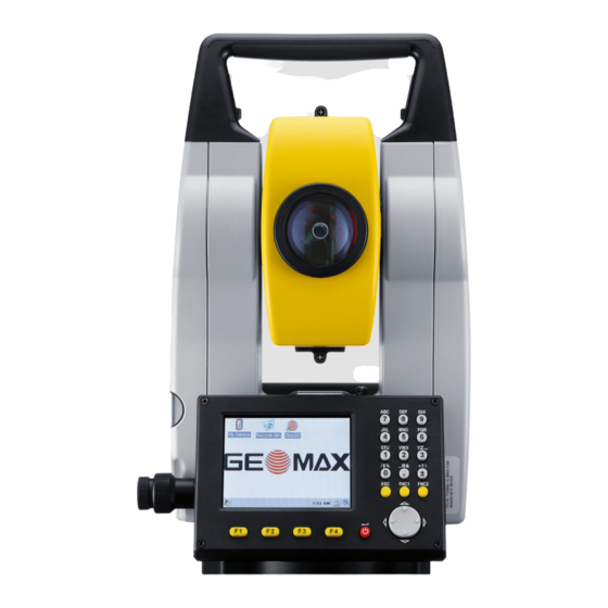
Instrument Components Instrument components part 1 of 2 a) Detachable carrying handle with mounting screw b) Optical sight c) Objective with integrated Electronic Distance Measurement (EDM). Exit for EDM laser beam d) Vertical drive e) Compartment for USB cable port and USB host port Leveling bubble g) Keyboard... -
Page 17: User Interface
User Interface Keyboard Alphanumeric keyboard a) Alphanumeric keypad b) FNC2 key c) FNC1 key d) ESC key Navigation key ON key / ENTER key g) Function keys F1 to F4 007380_001 Keys Description Alphanumeric keypad for entry of text and numerical values. ON key. -
Page 18: Status Icons
Status Icons Description The icons provide status information related to basic instrument functions. Depending on the firmware version, different icons may be displayed. Icons Icon Description The battery symbol indicates the level of the remaining battery capacity, 75% full shown in the example. -
Page 19: Operating Principles
Operating Principles Turn instrument on Press the ON key. Turn instrument off Return to WinCE main screen. Tap on the Windows icon in task bar to shut down the Zipp20. Alphanumeric keypad The alphanumerical keypad is used to enter characters directly into editable fields. •... -
Page 20: Operation
Operation Instrument Setup Description This topic describes an instrument setup over a marked ground point using the laser plummet. It is always possible to set up the instrument without the need for a marked ground point. Important features • It is always recommended to shield the instrument from direct sunlight and avoid uneven tempera- tures around the instrument. - Page 21 Level up with the elec- The electronic level can be used to level up the instrument precisely by using the footscrews of the tribrach. tronic level Turn the instrument until the tubular level is parallel to two footscrews. step-by-step Center the level on the instrument approximately by turning the footscrews of the tribrach. Turn on the instrument, and, if tilt correction is set on, the laser plummet activates automatically, and the Level up screen appears.
-
Page 22: Working With The Battery
• For Li-Ion batteries, a single discharging and charging cycle is sufficient. We recommend carrying out the process when the battery capacity indicated on the charger or on a GeoMax product deviates signif- icantly form the actual battery capacity available. -
Page 23: Survey Application
Survey Application Description The Survey application can be used to take immediately measurements. Access Select Survey from the MAIN MENU. Survey Survey softkeys The following softkeys are displayed on the Survey screen. Softkey Description MEAS Trigger measurement. Enter EDM Settings. Enter target height hr and station height hi. -
Page 24: Distance Measurements - Guidelines For Correct Results
Distance Measurements - Guidelines for Correct Results Description A laser distancer (EDM) is incorporated into the Zipp20 instruments. In all versions, the distance can be determined by using a visible red laser beam which emerges coaxially from the telescope objective. There are two EDM modes: •... -
Page 25: Settings
Settings Work Settings Access 1) Select Settings from the MAIN MENU. 2) Select Work from the SETTINGS menu. Work settings Field Description Tilt Corr. Tilting compensation deactivated. Two-axis compensation. Vertical angles refer to the plummet line and the horizontal directions are corrected by the standing axis tilt. -
Page 26: Regional Settings
Regional Settings Access 1) Select Settings from the MAIN MENU. 2) Select Regional from the SETTINGS menu. Regional settings Field Description H.A. Incr. Right Set horizontal angle to clockwise direction measurement. Left Set horizontal angle to counter-clockwise direction measure- ment. Counter-clockwise directions are displayed but are saved as clockwise directions. - Page 27 Field Description °F Degree Fahrenheit. Press. Unit Sets the units shown for all pressure fields. Hecto Pascal. mbar Millibar. mmHg Millimeter mercury. inHg Inch mercury. Time (24h) The current time. Date Shows an example of the selected date format. Format dd.mm.yyyy, How the date is shown in all date-related fields.
-
Page 28: Screen Settings
Screen Settings Access 1) Select Settings from the MAIN MENU. 2) Select Screen from the SETTINGS menu. Screen settings Field Description Screen Ill. Off to 100% Sets the display illumination in 20% steps. Cross. Ill. Sets the reticle illumination in three available steps: Low/Medium/High. Touch Screen The touch screen is activated. -
Page 29: Edm Settings
The refraction correction is taken into account in the calculation of the height differences and the horizontal distance. Refer to "9.6 Scale Correction" for the application of the values entered in this screen. When PPM=0 is selected, the GeoMax standard atmosphere of 1013.25 mbar, 12°C, and 60% relative humidity will be applied. Zipp20 | 29... - Page 30 PROJECTION SCALE This screen enables entry of the scale of projection. Coordinates are corrected with the PPM parameter. Refer to "9.6 Scale Correction" for the application of the values entered in this screen. Free-PPM Entry This screen enables the entry of individual scaling factors. Coordinates and distance measurements are corrected with the PPM parameter.
-
Page 31: Communication Settings
Communication Settings Description For data transfer the communication parameters of the instrument must be set. Access 1) Select Settings from the MAIN MENU. 2) Select Comm from the SETTINGS menu. COMMUNICATION SETTINGS BTCode The default Bluetooth code is ‘0000‘. Field Description Port Instrument port. -
Page 32: Tools
Overview Description GeoMax instruments are manufactured, assembled and adjusted to a high quality. Quick temperature changes, shock or stress can cause deviations and decrease the instrument accuracy. It is therefore recommended to calibrate the instrument from time to time. This can be done in the field by running through specific measurement procedures. -
Page 33: Calibrating Line-Of-Sight, Vertical Index Error And Compensator Index Error
6.1.3 Calibrating Line-of-Sight, Vertical Index Error and Compensator Index Error Line-of-sight error The line-of-sight error, or horizontal collimation error is the deviation from the perpendicular between the tilting axis and the line of sight. The effect of the line-of-sight error to the horizontal direction increases with the vertical angle. -
Page 34: Calibrating The Level Of The Instrument And Tribrach
6.1.4 Calibrating the Level of the Instrument and Tribrach Calibrate the level step-by-step Place and secure the tribrach onto the tripod, and then secure the instrument onto the tribrach. Using the tribrach footscrews, level the instrument with the electronic level. To activate the electronic level, turn on the instrument, and, if tilt correction is set on, the Level up screen appears automati- cally. -
Page 35: Inspecting The Laser Plummet Of The Instrument
3 mm at a height of 1.5 m. If the center of the laser dot makes a clearly circular movement, or moves more than 3 mm away from the point which was first marked, an adjustment may be required. Call your nearest GeoMax service department. -
Page 36: System Information
System Information Description The System information screens display instrument, system and firmware information, as well as settings for the date and time. Access 1) Select Tools from the MAIN MENU. 2) Select SysInfo from the TOOLS MENU. SYSTEM INFO This screen displays information about the instrument and operating system. Software information Field Description... -
Page 37: Working With Interfaces
005938_001 Always return to the Main Menu before removing the USB memory stick. GeoMax cannot be held responsible for data loss or any other error that may occur when using a USB memory stick. • Keep the USB memory stick dry. -
Page 38: Care And Transport
Shipping When transporting the product by rail, air or sea, always use the complete original GeoMax packaging, transport container and cardboard box, or its equivalent, to protect against shock and vibration. -
Page 39: Technical Data
Technical Data Angle Measurement Accuracy Available Standard deviation HA, Display resolution angular accura- VA, ISO 17123-3 cies ["] [mgon] ["] [°] [mgon] [mil] 0.0001 0.01 0.0001 0.01 Characteristics Absolute, continuous, diametric. Distance Measurement with Reflectors Range Reflector Range A Range B/C [ft] [ft] Standard prism... -
Page 40: Distance Measurements Without Reflectors (Reflectorless Mode)
FCC Part 15, 22 and 24 (applicable in US) Conformity to national • Hereby, GeoMax AG, declares that the product Zipp20 is in compliance with the essential requirements regulations and other relevant provisions of Directive 1999/5/EC. The declaration of conformity is available from GeoMax AG. -
Page 41: General Technical Data Of The Instrument
General Technical Data of the Instrument Magnification: 30 x Telescope Free Objective aperture: 40 mm Focusing: 1.7 m/5.6 ft to infinity Field of view: 1°30’/1.66 gon. 2.6 m at 100 m Compensation Quadruple axis compensation (2-axis compensator with HA-collimation and VA-Index). Angular accuracy Setting accuracy Setting range... - Page 42 Battery ZBA301 Type: Li-Ion Voltage: 8.4 V Capacity: 4.4 Ah Operating time: approximately 10 hours Environmental specifi- Temperature cations Type Operating temperature Storage temperature [°C] [°F] [°C] [°F] Instrument -20 to +50 -4 to +122 -40 to +70 -40 to +158 Battery -20 to +50 -4 to +122...
-
Page 43: Scale Correction
Scale Correction Use of scale correction By entering a scale correction, reductions proportional to distance can be taken into account. • Atmospheric correction. • Reduction to mean sea level. • Projection distortion. Atmospheric correction The slope distance displayed is correct if the scale correction in ppm, mm/km, which has been entered corresponds to the atmospheric conditions prevailing at the time of the measurement. -
Page 44: Reduction Formulas
Reduction Formulas Formulas Mean Sea Level Instrument Reflector Slope distance Horizontal distance Height difference The instrument calculates the slope distance, horizontal distance, and height difference in accordance with the following formulas. Earth curvature (1/R) and mean refraction coefficient (k = 0.13) are automatically taken into account when calculating the horizontal distance and height difference. -
Page 45: Software Licence Agreement
GeoMax. Such software is protected by copyright and other laws and its use is defined and regulated by the GeoMax Software Licence Agreement, which covers aspects such as, but not limited to, Scope of the Licence, Warranty, Intellectual Property Rights, Limitation of Liability, Exclusion of other Assurances, Governing Law and Place of Jurisdiction. -
Page 46: Glossary
Glossary Instrument axis ZA = Line of sight / collimation axis Telescope axis = line from the cross hairs to the center of the objective. SA = Standing axis Vertical rotation axis of the telescope. KA = Tilting axis Horizontal rotation axis of the telescope. Also known as the Trunion axis. - Page 47 Explanation of displayed Indicated meteorological corrected slope distance E, N, Z data between instrument tilting axis and center of prism/laser Indicated meteorological corrected horizontal distance Height difference between station and target point Reflector height above ground Instrument height above ground Stn.E, Stn.N, Stn.Z Easting, Northing and Height coordinates of station E, N, Z...
-
Page 48: Appendix A Menu Tree
Appendix A Menu Tree Depending on local firmware versions the menu items may differ. |—— Survey Menu Tree |—— Settings |—— Work |—— Tilt Correction, H.A. Correction |—— Regional |—— H.A. Incr., V.A. Setting, Language, Lang. Choise, Angle Unit, Min. Reading, Dist. -
Page 49: Appendix B Directory Structure
Appendix B Directory Structure Description On the USB memory stick, files are stored in certain directories. The following diagram is the default direc- tory structure. |—— SYSTEM • Firmware files Directory structure Zipp20 | 49 Directory Structure... - Page 50 GeoMax Zipp20 Series 820967-1.0.0en Original text © 2014 GeoMax AG, Widnau, Switzerland GeoMax AG www.geomax-positioning.com...
Need help?
Do you have a question about the Zipp20 series and is the answer not in the manual?
Questions and answers