Sign In
Upload
Manuals
Brands
Furuno Manuals
GPS
GP-3700F
User Manuals: Furuno GP-3700F GPS Chart Plotter
Manuals and User Guides for Furuno GP-3700F GPS Chart Plotter. We have
2
Furuno GP-3700F GPS Chart Plotter manuals available for free PDF download: Operator's Manual, Instruction Manual
Furuno GP-3700F Operator's Manual (224 pages)
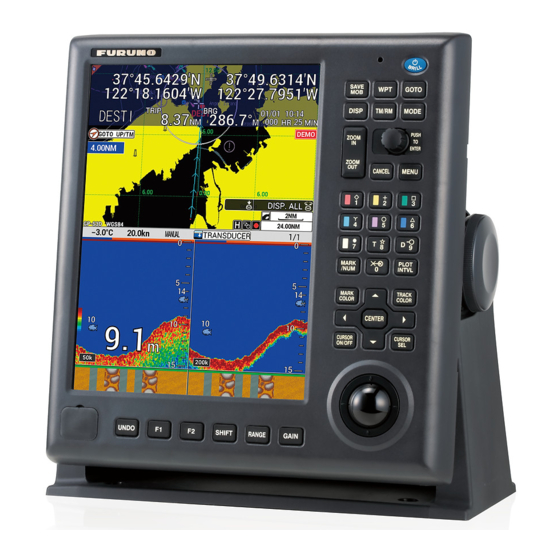
GPS/WAAS Color Chart Plotter with Fish Finder
Brand:
Furuno
| Category:
GPS
| Size: 24 MB
Table of Contents
Important Notices
3
Safety Instructions
4
Table of Contents
6
Foreword
11
System Configuration
13
1 Operational Overview
15
Controls
15
Display Unit
15
Trackball Control Unit RCU-030 (Option)
17
How to Turn the Power On/Off
17
How to Adjust the Brilliance of the Display and Panel
18
How to Select and Set a Display
19
How to Select a Display
19
How to Change a Display's Setting
19
How to Skip a Display
21
How to Set the Navigation/Destination Information
22
How to Switch the Active Screen
23
Menu Overview
23
MOB Operations
25
Function Keys
26
How to Operate a Function Key
26
How to Set up a Function Key
26
Demo Mode
28
2 Plotter Display Overview
31
Plotter Display
31
Plotter Display Layout
31
NAV Information Box
32
Compass Display
33
Satellite Status/Location Display
34
How to Use the Cursor
35
How to Change the Chart Scale (Zoom In, Zoom Out)
35
Orientation Mode
36
How to Shift the Display
37
How to Measure the Range and Bearing between Two Points
38
How to Change the Cursor Configuration
39
Chart Icons
41
3 Track
43
How to Show/Hide Track
43
How to Show/Hide Own Ship Track
43
How to Show/Hide Other Ship's Tracks and Symbols
45
How to Show/Hide the Current Vector
45
How to Show/Hide Drift Vector
46
How to Record Own Ship's Track
46
How to Stop/Restart Recording of Track
46
How to Show Track While Track Plotting Is Stopped
47
How to Connect Track after Restarting Plotting
47
How to Change Track Color
48
How to Change Track Color for Own Ship
48
How to Automatically Change Track Color for Own Ship with Water Temperature
48
How to Automatically Change Track Color for Own Ship with Depth
50
How to Change Track Color for Other Ship
51
How to Change Track Line Type
51
How to Change Track Line Type for Own Ship
51
How to Change Track Line Type for Other Ship
52
How to Select Track Plotting Method, Interval
52
How to Select the Track Plotting Method for Own Ship
52
How to Set the Track Plotting Intervals for Own Ship
52
How to Set the Track Plotting Intervals for Other Ship
53
How to Erase Own Ship Track
53
How to Edit Own Ship Track
55
How to Display Own Ship Information
56
Simple Information
56
Detailed Information
57
How to Display Other Ship Information
57
How to Change the Size of the Target Number
59
How to Erase Other Ship Track
60
4 Marks, Lines
61
How to Set Default Mark Appearance
61
How to Set Mark Color
61
How to Set Mark Size
62
How to Set Line Type
62
How to Set Fish Type for Marks
63
How to Enter Marks
63
How to Enter Marks at Own Ship Position
63
How to Enter Marks at the Cursor Position
64
How to Enter Marks by Manually Entering Latitude and Longitude Position
64
How to Enter Lines
65
How to Erase Marks, Lines
66
How to Edit Marks, Lines
67
How to Undo or Redo Mark/Line Operation
68
How to Show Mark Information
69
Mark Filter
70
5 Waypoints
75
How to Enter Waypoints
75
How to Enter Waypoints at Own Ship Position
75
How to Enter Waypoints at the Cursor Position
75
How to Enter Waypoints by Manually Entering Latitude and Longitude Position
76
How to Enter Waypoints by Range and Bearing
78
How to Enter Waypoints by Loran a or Loran C Lops
79
How to Enter Waypoints by Decca Lops
80
How to Edit Waypoints
81
How to Erase a Waypoint
82
How to Search Waypoints
82
How to Set Speed to Use in TTG Calculation
83
How to Display Waypoint Information
83
How to Change Waypoint Mark Size
84
How to Mark Radar Target Position
84
6 Routes
85
How to Create Routes
85
How to Create Routes with Existing Waypoints
85
How to Create Track-Based Routes Using Own Ship Position
87
How to Create Routes with Selected Tracks
88
How to Edit Routes
89
How to Insert Waypoints
89
How to Delete Waypoints from Routes
90
How to Delete Routes
90
How to Search Routes
90
How to Set the Speed to Use in TTG Calculation
91
7 Destination
93
How to Go to a Quick Point
93
How to Set a Waypoint as Destination
96
How to Follow Routes
98
How to Stop Navigation
100
8 Alarms
101
How to Turn the Audio Alarm On/Off
102
Arrival, Anchor Watch Alarm
103
Route Alarm
104
XTE, Border Alarm
104
Intrusion Point Alarm
105
Ship Speed Alarm
105
Trip Range Alarm
106
Water Temperature Alarm
106
Shear Alarm
107
Depth Alarm
108
9 Other Functions
109
COAST LINE SETTING] Menu
109
COAST LINE DETAIL SETTING] Menu
109
How to Display Depth Contour in Detail
112
PLOTTER DISPLAY SETTING] Menu
113
How to Set TD Display
113
How to Set Range for Plotter Display
116
DISPLAY FORMAT] Menu
116
NAVIGATOR SETUP] Menu
123
INPUT/OUTPUT PORT SETTING] Menu
126
How to Set the Ethernet
128
How to Display the Information for NMEA2000 Equipment
129
How to Set the NMEA2000
129
TEST & MEMORY CLEAR] Menu
130
How to Set or Change the Password
130
How to Disable the Password
131
How to Set the Trackball Sensitivity
131
Line Monitor
132
10 How to Record, Play Back Data
135
Data Recording
135
Internal Memory
135
How to Save the Data to the Internal Memory
135
How to Display the Data Stored in the Internal Memory
137
How to Play Back Data from the Internal Memory
138
How to Delete Data from the Internal Memory
139
USB Flash Memory Operations
139
How to Insert a USB Flash Memory
139
How to Safely Remove a USB Flash Memory
140
How to Save the Data to a USB Flash Memory
140
How to Play Back the Data from the USB Flash Memory
141
How to Transfer the Data from the USB Flash Memory
142
Backup Data
143
How to Backup the Data Automatically
143
How to Backup the Data Manually
144
How to Load the Backup Data
145
Screenshot (Screen Capture)
146
How to Load the Data from Other Equipment
147
11 Echo Sounder
149
How the Echo Sounder Operates
149
Echo Sounder Displays
149
Single Frequency Display (50 Khz or 200 Khz)
150
Dual Frequency Display
151
Marker Zoom Display (50 Khz or 200 Khz)
151
Bottom Zoom Display (50 Khz or 200 Khz)
152
Bottom Lock Display (50 Khz or 200 Khz)
152
Bottom Discrimination Display (50 Khz or 200 Khz)
153
A-Scope Display (50 Khz, 200 Khz or Dual Frequency)
153
MIX Display
154
Plotter/Echo Sounder Display
155
Automatic Echo Sounder Operation
156
How to Select an Automatic Echo Sounder Mode
156
How to Offset the Base Range or the Gain
156
Manual Echo Sounder Operation
157
How to Activate the Manual Echo Sounder Mode
157
How to Select the Display Range
158
How to Shift the Display Range
158
How to Adjust the Gain
159
How to Measure Depth, Time between Locations
160
How to Enter a Mark on the Display
161
How to Reduce Interference
161
How to Reduce Low Level Noise
162
How to Erase Weak Echoes
162
11.10 How to Highlight Echoes in White Color
163
1White Marker
163
2White Line
164
11.11 Display Colors
164
11.12 How to Customize Display Colors
165
11.13 Picture Advance Speed
166
11.14 How to Review Past Picture
166
1How to Set up to Display Past Picture
166
2How to Review Past Picture
167
Accu-Fish
168
1How to Set up ACCU-FISH
168
2How to Correct Measured Fish Size
169
3How to Select the Display Mode to Show Fish Information
169
4How to Select the Unit for Fish Length
170
11.16 Bottom Discrimination Display
170
11.17 Alarms
172
1Fish Alarm (Normal)
172
2Fish Alarm (Bottom Lock)
173
3Fish Alarm (Fish Size)
174
4Bottom Discrimination Alarm
174
11.18 [ECHO SOUNDER SYSTEM SETTING] Menu
175
11.19 Zero Line Rejection
176
11.20 Echo Sounder Range Setting Menu
177
11.21 Interpreting the Display
178
12 Ais Operations
183
AIS Symbols
183
How to Activate/Sleep Targets
184
AIS Tracks
185
How to Show/Hide AIS Tracks
185
How to Change the AIS Symbol/Track Color or Track Line Type
185
How to Stop/Restart Recording of AIS Track
185
AIS Target Data
186
How to Display the Individual AIS Target Data
186
How to Display the AIS List
187
AIS Alarm
188
How to Automatically Activate Targets
188
How to Activate the AIS Proximity Alarm
188
How to Set the CPA/TCPA Alarm
189
How to Set the Lost Alarm
189
How to Set the External AIS Alarm
190
13 Maintenance, Troubleshooting
191
13. Maintenance
191
Replacement of Fuse
192
Consumable Parts
192
Trackball Maintenance
192
Troubleshooting
193
Unit Information
195
Operation/Alarm Log
196
Diagnostics
197
Memory I/O Test
197
Keyboard Test
198
Test Pattern
198
How to Clear the Memory
199
How to Restore the Settings
199
How to Delete All Screenshot Data
199
How to Delete User Data
200
Appendix 1 Menu Tree
201
Appendix 2 Icons
211
Appendix 3 Time Differences
212
Appendix 4 What Is Sbas
213
Appendix 5 Alarm List
214
Specifications
216
Index
219
Declaration of Conformity
223
Advertisement
Furuno GP-3700F Instruction Manual (84 pages)
GPS/WAAS COLOR CHART PLOTTER with FISH FINDER
Brand:
Furuno
| Category:
Marine Equipment
| Size: 5 MB
Table of Contents
Table of Contents
1
Safety Instructions
3
System Configuration
4
Equipment Lists
5
1 Display Unit
9
Mounting
9
Antenna Unit
13
Installation of Transducers (Option)
14
Transom Mount Transducer
16
Inside Hull Mount
17
Installation of Sensors (Option)
24
Trackball Control Unit (Option)
25
External Monitor (Locally Supplied)
27
How to Connect the Unit
31
2 Wiring
31
DIP Switch Settings
41
Input/Output Data
41
3 Setting up the Equipment
47
Language Setting
48
Echo Sounder Setting
49
Sensor and NMEA Equipment Setting
50
Own Ship Information Setting
52
Event Switch Setting
54
Input/Output Port Setting
55
DGPS Setting
60
How to Control Charts
62
Appendix 1 Jis Cable Guide
65
Appendix 2 Installation for Transducer (Thru-Hull Mount
67
Appendix 3 Installation of Temperature Sensors
70
Advertisement
Related Products
Furuno GP-320B
Furuno GP-31
Furuno GP-36
Furuno GP-310B
Furuno GP-330B
Furuno GP-33
Furuno GP-3500
Furuno GP-35 Operators
Furuno GP-30 Operators
Furuno GP-39
Furuno Categories
Marine Radar
Marine Equipment
Sonar
Monitor
GPS
More Furuno Manuals
Login
Sign In
OR
Sign in with Facebook
Sign in with Google
Upload manual
Upload from disk
Upload from URL