Furuno GP-1670F Operator's Manual
Gps plotter/sounder
Hide thumbs
Also See for GP-1670F:
- Operator's manual (209 pages) ,
- Installation manual (21 pages) ,
- Operational procedure (8 pages)
Table of Contents
Advertisement
Quick Links
Advertisement
Table of Contents
Troubleshooting

Related Manuals for Furuno GP-1670F


Summary of Contents for Furuno GP-1670F
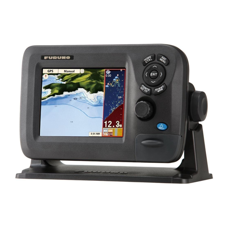
- Page 1 GPS PLOTTER/SOUNDER GP-1670F/GP-1870F Model www.furuno.com...
- Page 2 Nishinomiya, 662-8580, JAPAN A : JUN 2012 Printed in Japan All rights reserved. C : FEB . 15, 2013 Pub. No. OME-44770-C *00017659312* (TAHA ) GP-1670F/GP-1870F *00017659312* * 0 0 0 1 7 6 5 9 3 1 2 *...
- Page 3 How to discard a used battery Some FURUNO products have a battery(ies). To see if your product has a battery, see the chapter on Maintenance. Follow the instructions below if a battery is used. Tape the + and - terminals of battery before disposal to prevent fire, heat generation caused by short circuit.
- Page 4 Electrical shock can result. power at the switchboard and contact a FURUNO service technician. Use the proper fuse. Electrical current flows to the pins of Use of the wrong fuse can cause fire or the transducer connector when the electrical shock.
- Page 5 Injury can result if the glass breaks. Follow the compass safe distances shown below to prevent interference to a magnetic compass. Standard Steering compass compass GP-1670F 0.30 m 0.30 m GP-1870F 0.30 m 0.30 m Warning Label Do not remove the label.
-
Page 6: Table Of Contents
TABLE OF CONTENTS FOREWORD ........................ix SYSTEM CONFIGURATION ..................xi EQUIPMENT LISTS .......................xii OPERATIONAL OVERVIEW .................1-1 1.1 Controls........................1-1 1.1.1 Control description ..................1-1 1.2 RotoKey and Soft Controls ..................1-5 1.3 How to Turn the Power On or Off................1-6 1.4 How to Adjust the Display Brilliance................1-6 1.5 2D Plotter Displays..................... - Page 7 TABLE OF CONTENTS 3.2.3 How to enter a position manually on the plotter screen .........3-3 3.2.4 How to enter a point from the Points List ............3-3 3.3 How to Find Detailed Point Information ..............3-4 3.4 How to Move a Point ....................3-4 3.4.1 How to move a point on the screen..............3-4 3.4.2...
- Page 8 TABLE OF CONTENTS 6.3 3D Display........................6-6 6.3.1 3D display description ..................6-6 6.3.2 How to tilt and rotate the 3D display .............. 6-7 6.3.3 How to make the 3D view clearer ..............6-7 6.4 Satellite Photo Overlay....................6-8 FISH FINDER OPERATIONS ................7-1 7.1 How the Fish Finder Works..................
- Page 9 TABLE OF CONTENTS MEMORY CARD OPERATIONS ................9-1 9.1 The Memory Card Screen ..................9-1 9.2 How to Initialize SD Cards..................9-1 9.3 How to Eject an SD Card....................9-2 9.4 How to Save Data to an SD Card................9-2 9.5 How to Rename Files on an SD Card ................9-2 9.6 How to Delete Files from an SD Card ................9-3 9.6.1 How to delete individual files from an SD card..........9-3...
- Page 10 TABLE OF CONTENTS 13.6.1 INSTALLATION SETTINGS menu............. 13-19 13.6.2 CAN bus input/output ................. 13-21 APPENDIX 1 MENU TREE ..................AP-1 APPENDIX 2 ABBREVIATIONS, SYMBOLS ............AP-6 APPENDIX 3 JIS CABLE GUIDE ................AP-11 SPECIFICATIONS .....................SP-1 PACKING LISTS......................A-1 OUTLINE DRAWINGS....................D-1 INTERCONNECTION DIAGRAM ................S-1 INDEX..........................
-
Page 11: Foreword
A Word to GP-1670F, GP-1870F Owners Congratulations on your choice of the FURUNO GP-1670F, GP-1870F GPS Plotter/Sounder. We are confident you will see why the FURUNO name has become synonymous with quality and re- liability. Since 1948, FURUNO Electric Company has enjoyed an enviable reputation for innovative and dependable marine electronics equipment. - Page 12 FOREWORD Fish finder • Fish finder measures the depth to the bottom and displays underwater conditions in multi-col- ors* according to echo strength. A monochrome presentation shows the echoes in shades of gray. (*Number of colors depends on network sounder, color sounder.). •...
-
Page 13: System Configuration
GPS antenna unit Exposed to the weather, or protected from the weather in case of internal antenna Transducer, sensor Submerged in water Other units Protected from the weather GP-1670F Antenna Unit GPA-017 or GPA-017S Water temp./speed sensor ST-02MSB, ST-02PSB Display Unit Water temp. -
Page 14: Equipment Lists
000-021-070 1 set w/CP14-07101, MJ-A3SPF0013A- Materials 035C (power cable) Spare Parts SP14-03501 001-184-710 1 set Accessories FP14-03001 001-184-730 1 set For GP-1670F FP14-03201 001-183-120 1 set For GP-1870F Optional equipment Name Type Code no. Remarks Replacement Kit OP14-72 001-184-750 Waterproofing Cap... - Page 15 EQUIPMENT LISTS Name Type Code no. Remarks Temperature Sen- T-02MTB 000-040-026 Transom mount, 8 m cable T-02MSB 000-040-040 Thru-hull type T-03MSB 000-040-027 Thru-hull type, 8 m cable Matching Box MB-1100 000-041-353 For connection to 1 kW trans- ducer Rectifier PR-62 000-013-484 100 VAC Rectifier...
- Page 16 EQUIPMENT LISTS Name Type Code no. Remarks Termination Resis- LTWMN-05AFFT- 000-160-509-10 Mini style, female, termina- tor (Mini) SL8001 tion resistor Termination Resis- LTWMC-05BFFT- 000-168-605-10 Micro style, female, termina- tor (Micro) SL8001 tion resistor Inline Terminator FRU-0505-FF-IS 001-077-830-10 Cable Assy. 02S4147-1 000-141-082 For speed/temp.
-
Page 17: Operational Overview
1.1.1 Control description The controller for this system is either the GP-1670F or the GP-1870F. A key that has two text labels has two functions. The top label is the main function and the bottom label is the secondary function. Short-push to access the main function and long-push (approximately three seconds) to access the secondary function. - Page 18 1. OPERATIONAL OVERVIEW Control Description Short push: Display the base RotoKey soft controls for the current RotoKey mode. Long push: Display the full RotoKey soft controls for the current mode. Rotate: Zoom in or out the display range for the chart. Select a menu item.
- Page 19 1. OPERATIONAL OVERVIEW Tested SD cards The SD cards tested for use in this equipment are listed in the table below. Maker, Type Size 2 GB 4 GB 8 GB 16 GB 32 GB ADTEC AD-SDH (SD) [AD-SDH2G] BUFFALO RSDC-S (SD) [RSDC-S2G] RSDC-G Hi-Performance (SD) [RSDC-G2G] Hagiwara System T series (SD) [PSDB0487A]...
- Page 20 1. OPERATIONAL OVERVIEW Maker, Type Size 2 GB 4 GB 8GB 16 GB 32GB San Disk SanDisk (SD) [SDSDB-2048-J60] SanDisk (SDHC) [SDSDBR-4096-J85] SanDisk Ultra II (SDHC) CLASS 4 [SDSDRH-8192-903] SanDisk Ultra II (SD) [SDSDH-2048-903] SanDisk Ultra II (SDHC) [SDSDRH-4096-903] SanDisk Extreme III (SDHC) [SDSDRX3-4096-903] SanDisk Extreme (SDHC) [SDSDX3-016G-J31A] SanDisk Extreme (SDHC) [SDSDX3-032G-J31A] SILICON POWER...
-
Page 21: Rotokey Tm And Soft Controls
1. OPERATIONAL OVERVIEW RotoKey and Soft Controls The main function of the RotoKey is to display the RotoKey menu, a set of revolving soft controls that change with the operating mode. There are two sets of RotoKey menus: base and full. A short push of the key shows the base set for the current mode, and a long push displays the full compliment of soft controls for the current mode. -
Page 22: How To Turn The Power On Or Off
1. OPERATIONAL OVERVIEW How to Turn the Power On or Off To turn the power ON, press approx two seconds. Release when the FURUNO logo appears. It takes approx. 25-30 seconds to start the system, in the sequence shown below. - Page 23 1. OPERATIONAL OVERVIEW 2D plotter display, vector chart A vector chart is a series of points and lines that make up the features on a chart. Vec- tor charts look computer generated. Details on the chart can be turned on and off. Ob- jects on the chart can be clicked on to learn more details.
- Page 24 1. OPERATIONAL OVERVIEW 2D plotter display, vector/satellite The vector chart plus a satellite photo. See chapter 6 for how to adjust the satellite dis- play. 2D plotter display, raster A raster chart is a direct copy or scan of an existing paper chart. Raster charts look identical to paper charts.
-
Page 25: The Cursor
1. OPERATIONAL OVERVIEW The Cursor The cursor has the functions shown below. • Find, when put on respective item: • Position, range and bearing to cursor location • Point information • Route information • Track information • AIS target information •... -
Page 26: Navigation Data Boxes
1. OPERATIONAL OVERVIEW Navigation Data Boxes The navigation data boxes, displayed at the bottom of the screen, show various navi- gation data fed from the sensors connected to the display unit. Two or four boxes can be displayed and you can freely change the data shown in each box. The data that you can show depends on your system configuration. -
Page 27: Home Screen (Display Selection)
1. OPERATIONAL OVERVIEW Home Screen (Display Selection) 1.8.1 How to select a display The home screen has eight displays from which to choose. Press the HOME/CTRL key to show the home screen. Operate the CursorPad or rotate the RotoKey select a display. The current selection is circumscribed with a red rectangle. Press the RotoKey or ENT key to confirm your selection. -
Page 28: How To Customize The Home Screen
1. OPERATIONAL OVERVIEW 1.8.3 How to customize the home screen The home screen has seven screens that you can customize. (The full-screen plotter display cannot be customized. If you try to customize this display, the message “Can’t customize this display.” appears.) You can split the screen in up to four separate seg- ments. - Page 29 1. OPERATIONAL OVERVIEW 5. Select a display then push the RotoKey . For example, select the plotter dis- play. The chosen display appears at the location selected and the rectangle cur- sor moves to the adjacent screen. 6. Select a display for the right half then push the RotoKey .
-
Page 30: Display Range
1. OPERATIONAL OVERVIEW 1.8.4 Description of home screen displays Full screen displays Plotter: See page 1-7. Fish finder: See chapter 7. Tide & Celestial: Your plotter provides for calculation of the tide heights for any date. Additionally this display shows the time of sunrise, sunset, moonrise and moonset. See section 1.17. - Page 31 1. OPERATIONAL OVERVIEW Wind meter+navigation data x2: The wind meter provides analog and digital indications of wind angle. The wind meter is fixed; however, the two boxes of navigation data can be changed. Meter+navigation data x2: This display provides a meter plus two navigation data boxes.
- Page 32 1. OPERATIONAL OVERVIEW Quarter screens The figure below shows the available quarter screens. Like with the half screens you can select the navigation data to display in a quarter screen. Navigation data x1 Navigation data x2 Navigation data x3 Navigation data x4 Steering Wind angle Meter x1 (ex.
- Page 33 1. OPERATIONAL OVERVIEW How to select the data to display in a quarter screen, half screen navigation data 1. Display a home screen that has a quarter screen or a half screen with navigation data. 2. Long press the HOME/CTRL key to select the data display to change.
-
Page 34: Orientation Mode
1. OPERATIONAL OVERVIEW Display Range You can change the chart scale to change the amount of in- formation shown, or zoom in or out at the location you select, in the plotter and steering displays. The selected chart scale appears at the bottom right-hand position on the screen. The 20 NM available ranges depends on latitude and chart area. -
Page 35: How To Move The Chart
1. OPERATIONAL OVERVIEW Auto course-up: The course or heading is at the top of screen at the moment the auto course-up mode is selected. PT00001 5 NM 1.11 How to Move the Chart Move the chart in the following conditions. •... -
Page 36: Menu Operation
1. OPERATIONAL OVERVIEW 1.12 Menu Operation This section shows you how to operate the menu. There are eight menus, [General], [Map], [Plotter], [Alarms], [System], [Fish Finder], [Instruments] and [Interface]. 1. Long-push the ESC/MENU key to show the main menu. 2. Rotate the RotoKey to select a menu then push the key or the ENT key to dis- play that menu. -
Page 37: Object Information
• Chart object: [FULL INFO] Name PT0001 Position 34º41.006N The right figure shows detailed information for a 135º41.629E point. Time 02-24-12 12:46PM Temp 11.3º Depth 85.7 m Fish size 21, 18, 15, 07 cm Bottom type Mud 60% Comment FURUNO Detailed point information 1-21... -
Page 38: Context-Sensitive Menus
1. OPERATIONAL OVERVIEW 1.14 Context-Sensitive Menus The context-sensitive menus let you quickly access the functions related to the cursor- selected item. Select an applicable item then press the ENT key to show the related context-sensitive menu. Use the RotoKey to select a function. The table below shows the context-sensitive menus available in each category. - Page 39 1. OPERATIONAL OVERVIEW Item Context-sensitive menu Description Route (ac- [STOP]: Stop navigating the active route. STOP tive) [RESTART]: Restart navigating the active route. RESTART [REVERSE]: Follow the points in the active route in reverse order. REVERSE [INSERT]: Add a new point to the cursor position INSERT of the active route.
-
Page 40: Man Overboard (Mob)
1. OPERATIONAL OVERVIEW Item Context-sensitive menu Description Screen- [SAVE]: Copy the screenshots in the internal SAVE shots (IN- memory to the SD card. DELETE TERNAL) [DELETE]: Delete the screenshots. RENAME [RENAME]: Give the file a new name. PREVIEW [PREVIEW]: Show the screenshots selected on the screen. -
Page 41: Tide Information
1. OPERATIONAL OVERVIEW 1.17 Tide Information Your chart contains worldwide tide height and tidal current information. 1.17.1 Tide height information The tide station symbol appears at the locations of tide height recording stations. To get tide information from a tide station, put the cursor on the tide station symbol, press the ENT key then select [FULL INFO] from the context-sensitive menu to show the [OBJECTS] menu. -
Page 42: Tide Stream Information
1. OPERATIONAL OVERVIEW 1.17.2 Tide stream information This page is intentionally left blank. The tidal stream information is made from the tide stream data received from tide stream station. Tidal streams are marked with arrows. The size and color of the arrow indicate tide stream speed, Yellow, slow;... -
Page 43: Track
TRACK Your boat’s track is plotted on the display with position information fed from the inter- nal GPS navigator. This section shows you how to process track, from how to show or hide the track to how to change its color. How to Show, Hide all Track By soft control: Open the RotoKey menu then select [Track] to toggle the track dis- play ON and OFF. -
Page 44: How To Change The Color Of Your Boat's Track
2. TRACK How to Change the Color of Your Boat’s Track You can select the color for your boat’s track among red, green, light green, yellow, purple, orange, brown, and black. It is useful to change the color at regular intervals to distinguish tracks at different times of a day, for example. -
Page 45: How To Delete Track By Color
2. TRACK How to Delete Track by Color When the screen becomes cluttered with track, you may want to delete some track to clear up the display. You can delete track from the context-sensitive menu or the menu. How to delete track color from the menu 1. - Page 46 2. TRACK This page is intentionally left blank.
-
Page 47: Points
POINTS What is a Point? In navigation terminology, a point is any location you mark on the plotter display. A point can be a fishing spot, reference point and other important locations. You can use a point you have entered to set a destination and create a route. This unit has 30,000 points into which you can enter position information. -
Page 48: How To Enter A Point At The Cursor Position
3. POINTS 3.2.2 How to enter a point at the cursor position 1. Operate the CursorPad to put the cursor where desired then press the POINTS/ GOTO key. The “point” pop-up appears and shows point name, latitude and longitude position of the point, and distance and bearing to the point. -
Page 49: How To Enter A Position Manually On The Plotter Screen
3. POINTS [Hide]: Hide the icon and its name. [Icon]: Show only the icon. 8. Use [Comment] to enter a comment about the point, with the CursorPad. The de- fault comment is the time and date of entry of the point. A comment may have a maximum of 64 alphanumeric characters. -
Page 50: How To Find Detailed Point Information
Fish size 21, 18, 15, 07 cm Bottom type Mud 60% Comment FURUNO How to Move a Point You can move a point two ways: on the screen and from the [Points List]. 3.4.1 How to move a point on the screen Method 1: Drag the point to a new location 1. -
Page 51: How To Select Visibility For Points
3. POINTS How to Select Visibility for Points Points can be shown or hidden individually or collectively. 1. Open the [PLOTTER] menu and select [POINTS] to show the [Points List]. 2. Select the point to edit then press the ENT key. Note: If you want to assign visibility globally, select any point. -
Page 52: How To Filter Points By Shape On The Points List
3. POINTS How to Filter Points by Shape on the Points List You may filter points on the [Points List] by icon shape. This is useful when you are looking for points of a specific shape. 1. Open the [PLOTTER] menu and select [POINTS] to show the [Points List]. 2. -
Page 53: Routes
ROUTES What is a Route? Often a trip from one place to another involves several course changes, requiring a series of route points (waypoints) which you navigate to, one after another. The se- quence of waypoints leading to the ultimate destination is called a route. The equip- ment can store 1,000 routes, with a maximum of 50 points per route. -
Page 54: How To Create A Route From The Routes List
4. ROUTES 4.2.2 How to create a route from the Routes List A route can also be created from the [Routes List], with the points you have entered. 1. Open the [PLOTTER] menu and select [ROUTES] to show the [Routes List]. 2. -
Page 55: How To Create A Route With The Easy Routing Feature
Always remember that you should navigate with the most detailed and up-to-date chart available from FURUNO, and new information from National Hydrographic Offices may render your charts obsolete at any time. - Page 56 4. ROUTES How to set the safe values for Easy Routing Follow the procedure below to set the safe values to use in Easy Routing. 1. Open the [PLOTTER] menu and select [EASY ROUTING]. 6.6 ft 39.4 ft 0.0022 NM 5.0 min 2.
- Page 57 4. ROUTES 4. Select [EASY ROUTING] followed by [DESTINA- TION]. ER CALCULATING The destination point is marked with a green flag, Calculating route labeled [ER DEST]. Please wait 5. Press the ENT key then select [EASY ROUTING] followed by [CALCULATE]. A warning about the use of easy routing appears.
-
Page 58: How To Extend A Route On The Screen
4. ROUTES Error messages in Easy Routing Error message Meaning Remedy Latitude of the defined points is The latitude of the points is over Reselect the points. greater than 80°. Route has not 80°N/S. been calculated. No charts with Easy Routing You tried to use Easy Routing Insert appropriate chart card. -
Page 59: How To Insert A Point On A Route On The Screen
4. ROUTES How to Insert a Point on a Route on the Screen You can put a point between route legs when you need an additional point along a route. 1. Put the cursor on a leg of the route. 2. -
Page 60: Routes List
4. ROUTES Routes List 4.7.1 How to display the Routes List The [Routes List] shows all the routes saved to the internal memory. To show the [Routes List], open the [PLOTTER] menu and select [ROUTES]. Use the up and down arrows on the CursorPad to scroll the list. For multiple pages, switch between pages with the right and left arrows on the CursorPad. -
Page 61: Functions Available In The Routes List
4. ROUTES 4.7.2 Functions available in the Routes List Context-sensitive menu Select a route from the list then press the ENT key menu to show the context-sensitive menu. [DELETE]: Delete the selected route. EDIT [PLOT]: Display the selected route on the plotter display. DELETE [REVERSE]: Follow the selected route in reverse order. -
Page 62: Route Report, Route Calculator
4. ROUTES [Coord Type]: Select the position display format for points globally, among ddd’mm’ss, ddd°mm.mmm, ddd°mm.mmmm, ddd.dddddd. Route Report, Route Calculator A route report provides detailed information about a route plus a route navigation cal- culator. The route navigation calculator lets you see the time necessary to travel to each leg and the amount of fuel required for each leg with various speeds and fuel consumption figures. -
Page 63: How To Display A Route On The Screen
4. ROUTES How to Display a Route on the Screen Open the [PLOTTER] menu and select [ROUTES] to show the [Routes List]. Select a route then press the ENT key. Select [PLOT] from the context-sensitive menu then press the ENT key. 4.10 How to Connect Two Routes You can connect two routes from the [Routes List]. -
Page 64: How To Rename A Route On The Screen
4. ROUTES 4.12 How to Rename a Route on the Screen The default name for a route is RTXXXX (XXXX=route number). If desired, you can rename the route with one more descriptive. 1. Put the cursor on the route to rename then press the ENT key. 2. -
Page 65: Navigation
NAVIGATION This chapter shows you how to get to a desired destination by using “quick points,” saved points, and routes. Before you go to a point or follow a route, make sure the path to the points is clear. Zoom your chart to check for hazards which appear on a smaller scale. How to Navigate to a Quick Point The advantage of navigating to a quick point, the cursor position, is that you do not need to save the point to the memory. -
Page 66: How To Navigate To A Saved Point
Arrival area (red) Point (yellow by XTE alarm line default) (red) FURUNO Ship icon Navigation line Point (red) name 5.2.2 How to navigate to a point selected from the Points List 1. -
Page 67: Route Selected From The Routes List
5. NAVIGATION • A red line runs between the points on the route. The line shows the shortest path to the destination and the direction to go. Route point Arrival area (red) (yellow by default) PT00003 PT00002 XTE alarm line (red) PT00001 Navigation line... -
Page 68: Functions Available When You Follow A Route
5. NAVIGATION Functions Available When You Follow a Route 5.4.1 Restart navigation When you follow a route, you can restart the navigation to the next point on the Line 2 route from current location. When you steer to keep away from an ob- struction or your boat drifts, you go off course, like shown with Line 1 in the fig- ure. -
Page 69: Map Settings, 2D Perspective/3D Displays And Satellite Overlay
MAP SETTINGS, 2D PERSPEC- TIVE/3D DISPLAYS AND SATELLITE OVERLAY This chapter shows you how to set up the map display and how to select the 2D per- spective and 3D displays. Map Setup All map settings are in the [MAP] menu. On this menu you can •... - Page 70 6. MAP SETTINGS, 2D PERSPECTIVE/3D DISPLAYS AND SATELLITE OVERLAY [CHART LANGUAGE]: Use [Language] to select the chart language to use to show chart information (place names, etc.), among English and major European and Asian languages. Use [Mode] to select what language to display chart information in. [Off]: Chart information is shown in English when it is not available in the chart lan- guage selected.
- Page 71 6. MAP SETTINGS, 2D PERSPECTIVE/3D DISPLAYS AND SATELLITE OVERLAY DIsplay Level Item Available Settings Full Medium Tides MARINE SETTINGS NAMES On, Off HAZARD AREAS LA- On, Off BELS NAV-AID NAMES On, Off PORT NAMES On, Off NAV AIDS &LIGHT SEC- No sector No sector On, Off, No sector...
- Page 72 6. MAP SETTINGS, 2D PERSPECTIVE/3D DISPLAYS AND SATELLITE OVERLAY [FIND]: The find feature helps you locate ports, tide stations, wrecks, obstructions, and points of interests (attractions, medical service, entertainment, shopping, etc.). [COORDINATES] puts the cursor on the position you enter. For example, select [PORT BY DISTANCE] to find the ports closest to your current position.
-
Page 73: Perspective Dispay
6. MAP SETTINGS, 2D PERSPECTIVE/3D DISPLAYS AND SATELLITE OVERLAY 2D Perspective Dispay The 2D perspective display provides an aerial perspective display. Select [2D/3D] Mode and [2D Perspective] from the RotoKey menu to show this display. 2D display 2D perspective display... -
Page 74: Display
6. MAP SETTINGS, 2D PERSPECTIVE/3D DISPLAYS AND SATELLITE OVERLAY 3D Display 6.3.1 3D display description The 3D display has native 3D chart design that allows full time 3D presentation. This true 3D environment gives you all of the information you require with no restrictions on the information you can see. -
Page 75: How To Tilt And Rotate The 3D Display
6. MAP SETTINGS, 2D PERSPECTIVE/3D DISPLAYS AND SATELLITE OVERLAY 6.3.2 How to tilt and rotate the 3D display To tilt and rotate the 3D display, first select [Mode] and [Manual] from the RotoKey menu. [Manual] appears in the orientation mode box. Long-push the ENT key to en- able adjustment. -
Page 76: Satellite Photo Overlay
6. MAP SETTINGS, 2D PERSPECTIVE/3D DISPLAYS AND SATELLITE OVERLAY Satellite Photo Overlay You can overlay the satellite photo for your area on the 2D and 3D displays. Open the RotoKey menu then select [2D/3D Mode], [2D] or [3D] and [Vector/Satellite] to show the satellite photo. -
Page 77: Fish Finder Operations
FISH FINDER OPERATIONS How the Fish Finder Works The fish finder calculates the distance between its transducer and underwater objects like fish, lake bottom or seabed. The results are shown in different colors or shades of gray according to echo strength. The ultrasonic waves transmitted through water move at a constant speed of approx- imately 4800 feet (1500 meters) per second. -
Page 78: Fish Finder Display
7. FISH FINDER OPERATIONS Fish Finder Display The fish finder screen provides a “picture” of the echoes found by the fish finder. Ech- oes are scrolled across the screen from the right position to the left position. The num- ber of minutes an echo is displayed on the screen is controlled by the picture advance speed. -
Page 79: How To Activate The Fish Finder
7. FISH FINDER OPERATIONS How to Activate the Fish Finder Select a fish finder display at the home screen. See section 1.8. How to Select a Display Your fish finder has these display modes: single frequency (50 kHz or 200 kHz), dual frequency (50 kHz + 200 kHz), bottom lock, bottom zoom, marker zoom, A-scope, and bottom discrimination. -
Page 80: How To Select A Zoom Display
7. FISH FINDER OPERATIONS 7.4.2 How to select a zoom display The zoom displays appear on the left-half of the screen and the high or low frequency display on the right half. Three zoom displays are available: bottom lock, bottom zoom and marker zoom. -
Page 81: A-Scope Display
7. FISH FINDER OPERATIONS Marker zoom display The marker zoom display expands a selected area of the normal fish finder picture to full vertical size of the screen on the left-half window. You can select the part to ex- pand with the VRM (Variable Range Marker). Move the zoom marker with the Cursor- Pad. -
Page 82: Bottom Discrimination Display
7. FISH FINDER OPERATIONS 7.4.4 Bottom discrimination display The bottom discrimination display analyzes the bottom echo to categorize bottom hardness in one of four types (rocks, gravel, sand, mud) and shows the results in a colorful graphic display. A transducer or triducer that supports the bottom discrimina- tion display is required. - Page 83 7. FISH FINDER OPERATIONS • The 600 W transducers and triducers that support the bottom discrimination feature are 520-5PSD, 520-5MSD, 525-5PWD, 525STID-MSD, 525STID-PWD. • The 1 kW transducers that support the bottom discrimination feature are 50/200-1T and 50/200-12M. • The high and low frequencies are alternately transmitted, regardless of current dis- play selection.
-
Page 84: Automatic Fish Finder
7. FISH FINDER OPERATIONS Automatic Fish Finder Your fish finder can be adjusted automatically, allowing you to do other tasks. 7.5.1 How the automatic fish finder works The automatic fish finder function automatically adjusts the gain, clutter, TVG and echo offset. The main features of the automatic mode are as shown below. •... -
Page 85: Manual Fish Finder Operation
7. FISH FINDER OPERATIONS Manual Fish Finder Operation Use the manual operation to see schools of fish and the bottom echo with a fixed gain setting. The gain, range and range shift functions let you select the depth you can see on the screen. -
Page 86: How To Adjust The Gain
7. FISH FINDER OPERATIONS To adjust the shift, open the full RotoKey menu then select [Shift] to show the [Shift] window. Turn the key clockwise to in- crease the shift, counterclockwise to decrease the shift. 7.6.3 How to adjust the gain The gain controls how echoes of different strengths are dis- played. -
Page 87: Picture Advance Speed
7. FISH FINDER OPERATIONS Clutter Picture Advance Speed The picture advance speed controls how quickly the vertical scan lines move across the screen. A fast advance speed expands the size of a school of fish horizontally on the screen. A slow advance speed shortens the school of fish. Use a fast advance speed to see the hard bottom. -
Page 88: How To Reduce Interference
7. FISH FINDER OPERATIONS How to Reduce Interference Interference from other fish finders and electrical equipment appears on the screen as shown in the illustration. When these types of interference appear on the screen, use the interference rejector to reduce the interference. Three levels are available. Turn off the interference rejector when there is no interference, so that you do not erase weak echoes. -
Page 89: How To Measure Depth, Time Between Locations
7. FISH FINDER OPERATIONS 7.10 How to Measure Depth, Time Between Locations You can measure the depth to an object with the VRM. Also, you can measure the time from the right edge to a location. For example, you can measure how many minutes ago the echo appeared. -
Page 90: White Marker
7. FISH FINDER OPERATIONS 4. Press the ESC/MENU key to close the menu. 7.12 White Marker The white marker displays the selected echo strength in white. Use this feature to distinguish fish near the bottom from the bottom echo. Open the full RotoKey menu then select [Sensitivity] and [White Marker] to show the [White Marker] window. -
Page 91: How To Set An Alarm
7. FISH FINDER OPERATIONS 7.14.1 How to set an alarm 1. Open the [ALARMS] menu and select [FISH ALARM], [FISH ALARM (B/L)], [FISH SIZE ALARM] or [BOTTOM TYPE ALARM]. An alarm setting window appears. Depth 0.0 ft Min: 5 inch Probability 70 Range 5 ft Max: 199 inch... -
Page 92: Accu-Fish Tm
7. FISH FINDER OPERATIONS 7.15 ACCU-FISH The ACCU-FISH feature measures the length of individual fish and tags the fish with a fish symbol whose size is scaled to the length of the fish. The length or depth of the fish can be indicated digitally. Connection to a transducer that supports ACCU- FISH is required. -
Page 93: How To Activate Accu-Fish Tm , Select Display Information
7. FISH FINDER OPERATIONS 7.15.2 How to activate ACCU-FISH , select display information 1. Open the [FISH FINDER] and [ACCU-FISH] menus. 2. Select [FISH INFO] to activate or deactivate ACCU-FISH and select the infor- mation to display. [Off]: Deactivate ACCU-FISH [Fish Size]: Show fish size. -
Page 94: Water Temperature Graph
7. FISH FINDER OPERATIONS 7.16 Water Temperature Graph The water temperature graph, which requires a temperature sensor, shows the sur- face water temperature. The water temperature indication (line) moves across the screen from right to left. The water temperature scale is available in degrees Celsius or Fahrenheit, one of which you can select with [TEMPERATURE] in the [UNITS OF MEASURE] menu in the [SYSTEM] menu. -
Page 95: Fish Finder Menu
7. FISH FINDER OPERATIONS 7.17 FISH FINDER Menu This section provides the descriptions for the items in the [FISH FINDER] menu that have not been mentioned previously. Scroll [BACKGROUND COLOR]: Select the background color, among black, dark blue, light blue, white and monochrome (echoes appear in tones of gray.) [COLOR BAR]: Turn the color bar on or off. - Page 96 7. FISH FINDER OPERATIONS [FISH FINDER SETUP]: The [FISH FINDER SETUP] sub menu provides the following features. Scroll Item Function [TRANSMISSION] Turn transmission on or off. [TRANSMISSION POWER] Set the transmission power, [High] or [Low]. Interfer- ence may appear on the screen when an echo sounder having the same frequency as your own is being oper- ated in the vicinity of your boat.
- Page 97 CALIBRATION] vary depending on water conditions, which can affect the depth indication. Normally, adjustment of this setting is not necessary. If you feel the depth indication is continu- ously wrong, contact a FURUNO agent or dealer for ad- vice. 7-21...
-
Page 98: Interpreting The Display
7. FISH FINDER OPERATIONS [RANGES]: The default range settings are suitable for most applications. However, you can customize the ranges to suit your needs, with [RANGE 1] - [RANGE 8]. Set the ranges in descending order. Be sure that each range is higher than its preceding range. - Page 99 7. FISH FINDER OPERATIONS Bottom contour The tail from a hard bottom is longer than the tail from a soft bottom, because the hard bottom reflects more of the ultrasonic pulse. An echo from shallow water gives a stron- ger reflection than the echo received from deep water. A longer bottom tail appears on slopes, because of the difference in travel time at both edges of the beam angle.
- Page 100 7. FISH FINDER OPERATIONS Size of a school of fish Usually the size of fish echoes on the screen is proportional to the actual size of the school of fish. However, if two fish echoes appear at different depths with the same size, the school of fish at the shallower depth is displayed smaller because the ultra- sonic beam widens as it propagates and a school of fish in deep water is displayed larger.
- Page 101 7. FISH FINDER OPERATIONS Plankton A plankton layer appears as a large amount of green or blue dots, and is a possible location for fish. A plankton layer moves down in the day and School of fish up at night. Plankton Current rip When two ocean currents of different speeds di-...
- Page 102 7. FISH FINDER OPERATIONS False echo When an ultrasonic pulse is transmitted, some energy leaves from each side of the beam. This energy has the name "sidelobe". Echoes from sidelobes show on the screen as false images like in the illustration shown below. Mainlobe Mainlobe False image...
-
Page 103: Alarms
ALARMS The plotter section has 11 alarms that release audiovisual alarms when the specified conditions are met. These are • Anchor alarm • Arrival alarm • Black water tank alarm • Depth alarm • Fuel tank alarm • Shear alarm •... -
Page 104: Audio Alarm Conditions
8. ALARMS Audio Alarm Conditions The audio alarm can be enabled or disabled and the alarm interval selected. 1. Open the [ALARMS] menu then select [AUDIBLE ALARM]. 2. Select [Off] or [On] as appropriate. 3. Select [INTERVAL]. 4. Select the alarm interval desired, among [Short] or [Long]. 5. -
Page 105: Xte Alarm
8. ALARMS XTE Alarm The XTE (cross-track error) alarm warns you when your boat is off its intended course. You must set a destination to use this alarm. Own ship Destination Alarm position waypoint setting Intended course : Alarm area To set the XTE alarm: 1. -
Page 106: Shear Alarm
8. ALARMS Shear Alarm The shear alarm, which requires water temperature data, sounds when the tempera- ture exceeds the value set. To set the shear alarm: 1. Open the [ALARMS] menu then select [SHEAR ALARM]. 2. Confirm that the cursor is selecting the top line then push the RotoKey 3. -
Page 107: Anchor Alarm
8. ALARMS Anchor Alarm The anchor alarm informs you that your boat is moving when it should be at rest. Own ship position Alarm range : Alarm area To set the anchor alarm: 1. Open the [ALARMS] menu then select [ANCHOR ALARM]. 2. -
Page 108: Fuel Tank Alarm
8. ALARMS 8.11 Fuel Tank Alarm The fuel tank alarm warns you when the fuel level goes below the specified percent- age. To set the fuel tank alarm: 1. Open the [ALARMS] menu then select [FUEL TANK]. 2. Confirm that the cursor is selecting the top line then push the RotoKey 3. -
Page 109: Memory Card Operations
MEMORY CARD OPERATIONS This system uses SD and SDHC cards to store points, routes, tracks, settings, and screenshots. The system accepts cards of up to 32GB in size. The Memory Card Screen Open the [GENERAL] menu and select [MEMORY CARD] to show the [MEMORY CARD] screen. -
Page 110: How To Eject An Sd Card
9. MEMORY CARD OPERATIONS How to Eject an SD Card To prevent loss of data on an SD card, eject the SD card from the RotoKey menu. Open the Full RotoKey menu then select [Eject SD]. After ejecting the SD card, close the cover. -
Page 111: How To Delete Files From An Sd Card
9. MEMORY CARD OPERATIONS How to Delete Files from an SD Card 9.6.1 How to delete individual files from an SD card 1. Open the [GENERAL] menu and select [MEMORY CARD]. 2. Select the appropriate tab at the top of the screen then press the ENT key. 3. -
Page 112: How To Process Screenshots
9. MEMORY CARD OPERATIONS How to Process Screenshots The [Screenshots] tab process the screenshots saved to the memory and SD cards. You can save screenshots saved in the internal memory to the SD card and delete screenshots from both the internal memory and an SD card. 9.8.1 How to select source of screenshots (internal memory or SD card) -
Page 113: How To Delete Screenshots
9. MEMORY CARD OPERATIONS 9.8.3 How to delete screenshots How to delete individual screenshots 1. Open the [GENERAL] menu and select [MEMORY CARD]. 2. Select the [Screenshots] tab at the top of the screen then press the ENT key. 3. Select the SD card or internal memory as applicable. See section 9.8.1. 4. - Page 114 9. MEMORY CARD OPERATIONS This page is intentionally left blank.
-
Page 115: 10. Other Functions
10. OTHER FUNCTIONS 10.1 AIS Operations AIS (Automatic Identification System) is a system that continuously transmits the iden- tification and position of your boat to AIS transponder equipped vessels within com- municating range. All such vessels also receive data from other AIS transponder equipped vessels and display their positions and other relevant information. -
Page 116: How To Find Ais Target Information
10. OTHER FUNCTIONS 10.1.2 How to find AIS target information Put the cursor on an AIS target symbol to show AIS target information. Name FURUNO Latitude 34°39.0413N Longitude 135°21.8571E MMSI 456342110 Call Sign 1AB23 15.3 kn 234°T 235°T 3.28 NM... -
Page 117: Dsc Message Information
10. OTHER FUNCTIONS 10.2 DSC Message Information The DSC (Digital Selective Calling) message information feature alerts you when you have received a DSC position request or a DSC distress call, via an SSB radiotele- phone. The icon marks the position of the vessel that sent the request or call on the plotter display, at the time the message was sent. -
Page 118: Stopwatch, Timer
10. OTHER FUNCTIONS 10.3 Stopwatch, Timer A stopwatch or timer is available on a navigation data display. (The stopwatch and tim- er cannot be used simultaneously.) The stopwatch counts elapsed time and the timer counts down the time from a specified time interval. To enable the stopwatch or timer, do the following. -
Page 119: How To Select Input, Output Data
In this case, the device with the lowest IP address has priority. If the external source is a FURUNO make, its name appears below [Auto]. Select it to have that device feed respective data. -
Page 120: Output Data
10. OTHER FUNCTIONS 10.4.2 Output data Open the [INTERFACE] menu and select [SELECT OUTPUT PGN]. Select the item to process. Select [On] or [Off] as appropriate. Scroll (ENVT. PARAMETERS) 10-6... -
Page 121: Engine Display Setup (Instruments Menu)
10. OTHER FUNCTIONS 10.5 Engine Display Setup (INSTRUMENTS menu) Set your engine’s specifications on the [INSTRUMENTS] menu to get correct informa- tion on the engine displays. 80° to 320°F 80° to 320°F 80° to 320°F Item Options Remarks ENGINE RPM 4000, 6000, 8000 rpm Set max. - Page 122 10. OTHER FUNCTIONS This page is intentionally left blank. 10-8...
-
Page 123: 11. Customizing Your Unit
11. CUSTOMIZING YOUR UNIT The default settings are suitable for a wide variety of applications. However, you may wish to customize settings to meet your environment, operational needs, local char- acteristics, etc. This chapter provides descriptions of the menu items not previously described, to help you determine the settings right for you. -
Page 124: Plotter Menu
11. CUSTOMIZING YOUR UNIT 11.2 PLOTTER Menu [COG LINE]: The tip of the COG line is your estimated position at the end of the time interval selected here. The COG line can be a valuable tool for evaluating the risk of collision with another vessel if AIS targets are displayed. -
Page 125: System Menu
11. CUSTOMIZING YOUR UNIT 11.3 SYSTEM Menu SYSTEM INFORMATION [LANGUAGE]: Select the language among English and major European and Asian languages. [UNITS OF MEASURE]: The default units of measure are based on the language se- lected. However, you can freely set the units of measure for distance, speed, wind speed, depth, fish size, temperature, air pressure, oil pressure, and fuel. - Page 126 11. CUSTOMIZING YOUR UNIT setting if the GPS fix changes greatly. [SPEED FILTER]: During position fixing, ship's velocity (speed) is directly measured from the GPS satellite. The raw velocity data may change randomly depending on re- ceiving conditions and other factors. You can reduce this random variation by increas- ing the filter setting.
- Page 127 11. CUSTOMIZING YOUR UNIT [RESTART GPS]: Restart reception of GPS satellites. [NAVIGATION SPEED]: Set different dynamic platform models to adjust the naviga- tion engine to the expected application environment. [Low] corresponds to pedestrian dynamic platform model. For applications with low acceleration and speed. [High] cor- responds to at sea dynamic platform model.
- Page 128 11. CUSTOMIZING YOUR UNIT This page is intentionally left blank. 11-6...
-
Page 129: Maintenance, Troubleshooting
12. MAINTENANCE, TROUBLESHOOTING This section provides maintenance and troubleshooting procedures that the user can follow to get optimum performance from the equipment. Before attempting any main- tenance or troubleshooting procedure please review the safety information below. If you cannot restore normal operation after following the troubleshooting procedures do not attempt to check inside the equipment;... -
Page 130: How To Replace The Fuse
12. MAINTENANCE, TROUBLESHOOTING 12.2 How to Replace the Fuse The fuse (3A) in the fuse holder on the power cable protects the display unit from high electric current and equipment fault. If you cannot turn on the power, check the fuse to see if it has blown. - Page 131 12. MAINTENANCE, TROUBLESHOOTING Problem Remedy The speed indication Set [NAVIGATION SPEED] to [Low] in the [INTERNAL GPS is not zero after the SETUP] in the [SYSTEM] menu. ship is stopped. Fish Finder Troubleshooting You selected a fish • Check that the transducer cable is fastened. finder display, but no •...
-
Page 132: Gps Status Display
12. MAINTENANCE, TROUBLESHOOTING 12.4 GPS Status Display The GPS status display shows the RX signal strength and the location of each GPS satellite received. By default, the GPS status display is provided on a home screen. GPS 3D Description of GPS status display •... -
Page 133: How To Restore Defaults, Clear Memory
12. MAINTENANCE, TROUBLESHOOTING 12.5 How to Restore Defaults, Clear Memory You may wish to restore default or user settings. 1. Open the [SYSTEM] menu then select [DEFAULT SETTINGS]. 2. Select one of the following according to your objective. [FACTORY DEFAULT]: Restore all default factory settings. User-saved items (waypoint, routes, etc.) are not erased. -
Page 134: System Information
12. MAINTENANCE, TROUBLESHOOTING 12.6 System Information The system information display, for use by the service technician, shows chart oper- ating system information, license information and the data access manager report. Open the [SYSTEM] menu and select [SYSTEM INFORMATION] to show the charting operating system display. -
Page 135: 13. Installation
13. INSTALLATION 13.1 Installation of Display Unit Mounting considerations The display unit can be installed on a tabletop or flush mounted in a console. Select a suitable mounting location considering the following: • Keep the display unit out of direct sunlight. •... -
Page 136: Installation Of Antenna Unit
13. INSTALLATION 13.2 Installation of Antenna Unit Mounting considerations The antenna unit GPA-017/017S (option) is available for receiving GPS signal with far- ther sensitivity. Select a suitable mounting location considering the following: • Select a location out of the radar beam. The radar beam will obstruct or prevent re- ception of the GPS satellite signal. - Page 137 13. INSTALLATION in a position where water flow is the smoothest. Noise from the propellers also ad- versely affects performance and the transducer should not be mounted nearby. The lifting strakes are notorious for creating acoustic noise, and these must be avoided by keeping the transducer inboard of them.
- Page 138 13. INSTALLATION disturbed flow of water around the transducer. The fairing block should be smaller than the transducer itself to provide a channel to divert turbulent water around the sides of the transducer rather than over its face. Hole for stuffing tube Upper Half Lower Half...
-
Page 139: Transom Mount Transducer
13. INSTALLATION 13.3.2 Transom mount transducer The optional transom mount transducer is very commonly employed, usually on rela- tively small I/O or outboard boats. Do not use this method on an inboard motor boat because turbulence is created by the propeller ahead of the transducer. DO NOT overtighten screws, to prevent damage to the transducer. -
Page 140: How To Mount A Transducer Inside The Hull
13. INSTALLATION 13.3.3 How to mount a transducer inside the hull The transducer may also be installed inside the hull on FRP boats. However, this in- stallation method affects the ability to detect the bottom, fish and other objects be- cause the ultrasound pulse is weakened when it passes through the hull. -
Page 141: Triducer
13. INSTALLATION 3. Wipe off any sandpaper dust from the face of the transducer. 4. Dry the face of the transducer and the hull. Coat the transducer face and mounting location with silicone sealant. Hardening begins in approx. 15-20 minutes so do this step without delay. - Page 142 13. INSTALLATION Pre-test for speed and temperature Connect the sensor to the instrument and spin the paddlewheel. Check for a speed reading and the approximate air temperature. If there is no reading, return the sensor to your place of purchase. Tools and materials required •...
- Page 143 13. INSTALLATION How to install the bracket 1. .Cut out the installation template (enclosed with transducer) along the dotted line. 2. At the selected location, position the template, so the arrow at the bottom is aligned with the bottom edge of the transom. Being sure the template is parallel to the waterline, tape it in place.
- Page 144 13. INSTALLATION 19°-22° transom angle (small aluminum and fiberglass boats): Position the shim with the tapered end up. 11º transom angle 2º-10º 19º-22º NO SHIM transom transom angle angle shim with shim with taper down taper up parallel parallel parallel 12º-18º...
- Page 145 13. INSTALLATION How to attach the sensor to the bracket 1. If the retaining cover near the top of the bracket is closed, open it by depressing the latch and rotating the cover downward. Step 1 Step 2 Latch Pivot Retaining Slot cover...
-
Page 146: Installation Of Sensors (Option)
13. INSTALLATION 7. Apply marine sealant to the threads of the #6 x 1/2” self-tapping screw to prevent water from seeping into the transom. If you have drilled a hole through the tran- som, apply marine sealant to the space around the cable where it passes through the transom. -
Page 147: Temperature Sensors
13. INSTALLATION 8. Launch your boat and check for water leakage around the sensor. Locknut Face "notch" toward bow. Flange nut Coat with Brim silicone sealant. ø Unit: mm 13.4.2 Temperature sensors Transom mount temperature sensor T-02MTB • Fix the cable at a convenient location on the transom with the cable clamp. •... - Page 148 13. INSTALLATION T-02MSB T-03MSB Sensor Holder Cable Sensor cable Locknut Locknut Washer Gasket Locknut Washer ø21 mm Gasket ø25 mm Coat with sealant. Coat with sealant. ø42 Plate thick- Mounting procedure ø50 ness within 1. Drill a hole of 21 mm in diameter in Holder Guide 25 mm the mounting location.
-
Page 149: Wiring
13. INSTALLATION 13.5 Wiring All wiring are terminated at the rear of the display unit. Refer to the interconnection diagram on page S-1. Display unit (back) No use WARNING ELECTRICAL SHOCK CAN bus equipment DO NOT touch the pins inside the connector. - Page 150 13. INSTALLATION GPS antenna unit (option) Connect the antenna cable to the GPS connector. How to attach the M-P-8DFB connector Dimensions in millimeters. Outer sheath Armor Inner sheath Shield Remove outer sheath and armor by the dimensions shown left. Expose inner sheath and shield by the dimensions shown left. Cover with heat-shrink tubing and heat.
- Page 151 13. INSTALLATION How to extend cable length (GPA-017S) The standard cable is 10 m long. For extension, in case of the GPA-017S, an antenna cable set of 30 m or 50 m is available. Extension cable cannot be used with the GPA- 017.
- Page 152 All the CAN bus devices can be incorporated into the NMEA2000 network. For detailed information about CAN bus wiring, see “Furuno CAN bus Network Design Guide” (Type: TIE-00170) on Tech-Net), or contact your dealer.
-
Page 153: Initial Settings
13. INSTALLATION 13.6 Initial Settings 13.6.1 INSTALLATION SETTINGS menu The first time the system is powered, the [INSTALLATION SETTINGS] menu appears. Enter basic settings, following the procedure below. 1. If your language is English USA, the default language, go to step 4. 2. - Page 154 13. INSTALLATION 4. Rotate the RotoKey to select [UNITS OF MEASURE] then push the key. °F The units of measure are automatically changed according to the language select- ed. The available units are as shown in the table below. Item Available units Item Available units...
-
Page 155: Can Bus Input/Output
GPS. In this case, the navigator with the low- est IP address has priority. If you have a FURUNO external navigator speed/course source connected, its name appears below [Auto]. Select the model name to have that device feed corresponding data. - Page 156 13. INSTALLATION If the external source is a FURUNO make, its name appears below [Auto]. Se- lect the device name to have the device feed respective data. 4) Other items are selected to [Auto]. Respective data are input if associated de- vice is connected to the system.
- Page 157 13. INSTALLATION Description 127488 Engine Parameters, Rapid Update 127489 Engine Parameters, Dynamic 127493 Transmission Parameters 127496 Trip Parameter, Vessel 127505 Fluid Level 128259 Speed 128267 Water Depth 129025 Position, Rapid Update 129026 COG & SOG, Rapid Update 129029 GNSS Position Data 129033 Time &...
- Page 158 13. INSTALLATION Output PGN Description Output cycle (msec) 059392 ISO Acknowledgement 059904 ISO Request 060928 ISO Address Claim 126208 NMEA-Request Group Function NMEA-Command Group Function NMEA-Acknowledge Group Function 126464 Transmit PGN’s Group Function System Time 1000 126992 126996 Production Information Magnetic Variation 1000 127258...
-
Page 159: Appendix 1 Menu Tree
APPENDIX 1 MENU TREE ESC/MENU GENERAL KEYPAD BEEP (On, Off) (long press) PALETTE (Sunlight, Night, Normal) FONT SIZE (Large, Small) TIME OFFSET (UTC) DAYLIGHT SAVING TIME (On, Off) TIME FORMAT (12 Hours, 24 Hours) DATE FORMAT (MM-DD-YY, DD-MM-YY) MEMORY CARD (SD card operations) ICON SIZE (Standard, Large) PLACE NAMES SIZE (Standard, Medium, Large) NAV AIDS PRESENTATION (US, International) - Page 160 APPENDIX 1 MENU TREE (Con’t from previous page) Standard land VAD - [Free Value Added Data] DISPLAY (On, Off, Custom) CUSTOMIZE Road (On, Off) Land Elevation (On, Off) Standard Marine VAD - [Free Value Added Data] DISPLAY (On, Off, Custom) CUSTOMIZE Tide height station (On, Off) Port/Marina (On, Off)
- Page 161 APPENDIX 1 MENU TREE (Con’t from previous page) LANGUAGE (English, others) SYSTEM UNITS OF DISTANCE (NM, SM, km, NM+ft, NM+m, SM+ft) MEASURE SPEED (kn, mph, km/h) WIND SPEED (kn, m/s, mph, Bft) DEPTH (m, ft, fm, pb, HR) FISH SIZE (cm, inch) TEMPERATURE (°F, °C) AIR PRESSURE (Bar, hPa) OIL PRESSURE (Bar, PSI, kPa)
- Page 162 APPENDIX 1 MENU TREE (Con’t from previous page) BACKGROUND COLOR (Black, Dark blue, Light blue, White, Monochrome) FISH PICTURE ADVANCE (STOP, 1/16, 1/8, 1/4, 1/2, 1/1, 2/1) FINDER TEMPERATURE GRAPH (On, Off) ZOOM MARKER (On, Off) A-SCOPE (On, Off) A-SCOPE PEAK HOLD (On, Off) COLOR BAR (On, Off) BOTTOM RANGE SHIFT AREA (Upper Limit: 15 to 85;...
- Page 163 APPENDIX 1 MENU TREE (Con’t from previous page) INTERFACE CAN BUS MONITOR (Devices, General, TX PGN List, RX PGN List, Transmitted PGNs) SELECT INPUT POSITION & SOG/COG (Internal GPS, Auto) DEVICE DEPTH (Fish Finder, Auto) WATER TEMPERATURE (Fish Finder, Auto) SPEED THROUGH WATER (Fish Finder, Auto) HEADING (Auto) AIR TEMPERATURE (Auto)
-
Page 164: Appendix 2 Abbreviations, Symbols
APPENDIX 2 ABBREVIATIONS, SYMBOLS Abbreviations Abbreviation Meaning Two Dimensional Three Dimensional A-PRS Air Pressure A-TMP Air Temperature Automatic Identification System Ante Meridiem Atlantic Ocean Region AUTO Automatic B-type Bottom type Barometric Beaufort BIOS Basic Input/Output System BOOST Engine Boost Pressure Bearing Celsius C-TMP... - Page 165 APPENDIX 2 ABBREVIATIONS, SYMBOLS Abbreviation Meaning Fast File fathoms feet FUEL Fuel Rate FUEL-P Fuel Pressure FUEL-R Fuel Rate GAIN H Gain High (frequency) GAIN L Gain Low (frequency) gallon GNSS Global Navigation Satellite System Global Positioning System Heading HDOP Horizontal Dilution of Precision hour HOUR...
- Page 166 APPENDIX 2 ABBREVIATIONS, SYMBOLS Abbreviation Meaning Post Meridiem Pacific Ocean Region Position Per Square Inch Point Quick Point Resolution Rate Of Turn Route RUDDR Rudder South Secure Digital SDHC Secure Digital High capacity Software Development Kit second(s) Simulation Satellite statute mile Speed Over the Ground Speed Through Water Symbol...
- Page 167 APPENDIX 2 ABBREVIATIONS, SYMBOLS Symbols Plotter display symbols Item Symbol Cursor (two types) : Active : Inactive (red) MOB (ManOverBoard) mark (red) Ship icon (three types) Icon 1 Icon 2 Icon 3 Ship icon+COG line Ship icon+Heading line (red) Ship icon+track Point (single point and route point) (default: yellow) AP-9...
- Page 168 APPENDIX 2 ABBREVIATIONS, SYMBOLS Alarm symbols ALARM SYMBOL ALARM SYMBOL ARRIVAL ALARM FISH ALARM (B/L) ANCHOR ALARM FISH SIZE CROSS TRACK ERROR BOTTOM TYPE SPEED ALARM FUEL TANK TRIP ALARM WATER TANK TEMPERATURE ALARM BLACK-WATER TANK SHEAR ALARM CPA ALARM TCPA ALARM DEPTH ALARM FISH ALARM...
- Page 169 EX: DPYCYSLA - 1.5 MPYC - 4 TTYCSLA-4 Core Area (mm Designation type Designation type # of cores The following reference table lists gives the measurements of JIS cables commonly used with Furuno products: Core Cable Core Cable Diameter Diameter...
-
Page 170: Appendix 3 Jis Cable Guide
APPENDIX 3 JIS CABLE GUIDE This page is intentionally left blank. AP-12... -
Page 171: Specifications
FURUNO GP-1670F/1870F SPECIFICATIONS OF GPS PLOTTER/SOUNDER GP-1670F/1870F GENERAL Display GP-1670F 5.7-inch TFT color LCD, 640 x 480 dots GP-1870F 7.0-inch TFT color LCD, 800 x 480 dots Display mode Plotter, Plotter/Sounder, Sounder, Highway, Waypoint display Projection Mercator Useable area 80° latitude or below... - Page 172 FURUNO GP-1670F/1870F Range Basic range: 5 to 1200 m, Shift: 0 to 1200 m Picture advance speed 7 steps Other functions ACCU-FISH , A-scope, bottom discrimination, Automatic mode (cruising/fishing) INTERFACE I/O port CAN bus, USB for maintenance Data format IEC61162-1/NMEA Ver1.5/2.0/3.0 (data converter required)
-
Page 181: Index
INDEX Numerics Controls............. 1-1 Course-up ..........1-18 2D perspective dispay....... 6-5 CPA alarm..........10-2 3D display Cursor ............1-9 description ..........6-6 exaggeration ........... 6-7 tilt............. 6-7 DAM report..........12-6 Defaults restore........12-5 Depth alarm..........8-4 ACCU-FISH Depth indication ........7-21 activating, deactivating ...... - Page 182 INDEX chart display ..........6-2 creating, from RotoKey menu ....4-1 chart language .........6-2 creating, from routes list......4-2 icon size ...........6-1 creating, with easy routing .......4-3 map configuration........6-2 deleting...........4-12 nav aids presentation .......6-1 deleting points from........4-7 place name size ........6-1 displaying ..........4-11 Marker zoom display ........7-5 editing............4-9 Memory cards...
- Page 183 INDEX recording interval........2-1 recording method ........2-1 stopping recording of....... 2-1 Transmission power ........ 7-20 Trip alarm ..........8-5 Troubleshooting ........12-2 TVG............7-13 VRM ............7-13 Water tank alarm........8-6 Water temperature graph ......7-18 White line ..........7-14 White marker...........
- Page 184 When a claim is made, FURUNO has a right to choose whether with other electronic devices. The imported product may also be to repair the product or replace it.
- Page 185 24 months from installation date provided the work is done by Furuno U.S.A., Inc. or an AUTHORIZED Furuno dealer during normal shop hours and within a radius of 50 miles of the shop location.
Need help?
Do you have a question about the GP-1670F and is the answer not in the manual?
Questions and answers