Table of Contents
Advertisement
Quick Links
QFinder User's Manual
A. Overview
QFinder utilizes the GPS technology to mark your desired locations and allows you to be
back to the locations later at anytime by the precise digital compass with 8‐directional
arrows. It's a pretty practical tool in terms of hiking, camping, kayaking, fishing, parking,
and traveling.
B. Product Notice
QFinder must be used outdoors because it utilizes GPS technology to mark
locations. Indoor environment will cause the device unable to receive satellite
signals to find your location and movement, such as in am indoor parking garage
For the first time use or not use after a long time of the device, it would need more
time to get GPS fixed.
The manufacturer assumes no responsibility for any damages and loss resulting
from the use of this manual or from misuse of the product in any way
Please clean the unit with a dry and clean soft close. Do not use harsh cleaning
solvents, chemicals, alcohol, or strong detergents
Do not attempt to take apart the device by yourself. Unauthorized hacking may
damage the unit, and void your warranty
C. Standard Package
1. QFinder
D. Features
4 location back points (A/B/C/D point)
The estimate straight line distance measuring of the location back points
LCD Display with Backlight
Support Digital Compass with 8‐directional arrow
Support Temperature and Real Time (Time Zone adjustable)
Adopts SiRF Star III GPS GPS chipset
High sensitivity ‐159dBm and 20‐Channel tracking
Smart power saving and operates on 2 AAA batteries (not included)
IPX‐6 Water resistance
Support standard NMEA‐0183 protocol
2 x AAA batteries (for both alkaline and rechargeable)
Operation Current
<55mA (Typical)
Operation Time
12hrs,
E‐Compass
4 location back (A/B/C/D marks)
Temperature ( ℃ / ℉)
Time display
Operating Temperature
0 ℃ to + 60 ℃
Storage Temperature
‐ 20 ℃ to + 70 ℃
Water resistance
IPX‐6
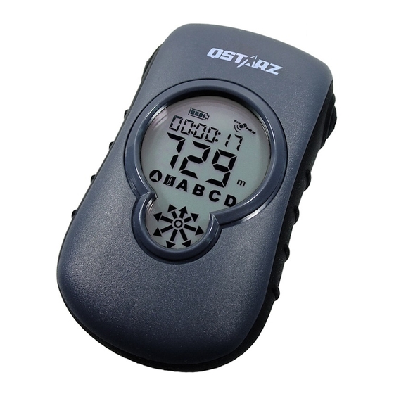
F. Appearance
Icon Indicators:
Battery status
GPS Fix
GPS not Fix
(Flash)
2. Neck Lanyard
Power
Functionality
Accessories
Lanyard
Environmental
Compass mode
Temperature Mode
A/B/C/D location mode
E. Product Specification
GPS Chip
SiRF Star III
Frequency
L1, 1575.42MHz
C/A Code
1.023MHz chip rate
Channels
Support 20 channels
Antenna (Intemal)
Built‐in low noise antenna
To ‐159dBm Tracking, Superior Urban Canyon Performance
Cold Start
42 sec, average
Warm Start
38 sec, average
Hot Start
1 sec, average
Reacquisition
0.1sec
Position
<10 M at 2D RMS
Velocity
0.1m/sec, without SA
Time
1μs synchronized to GPS time
Dynamic Conditions
Altitude
<18,000m
Velocity
<515m/sec
Acceleration
<4G
Motional Jerk
4 m/sec.
LCM‐ICON 33x42mm display size
2 Buttons (Power/Mode and Mark/Backlight)
Default: NMEA‐0183 – GGA, GSA, GSV, GLL, RMC,VTG
Baud rate 4800~38400 bps, Data bit : 8, stop bit : 1(Default) *
100g (excluding battery)
G. Hardware Function
Hardware Function
Power on/off the
Hold Mode/Power button for 1sec to power on; hold
device
Mode/Power button again for 3sec to power off
After power on, short push Mode/Power button to
Mode switch
switch among different modes
Short push Mode/Power button to select either
Mark location
A/B/C/D location and hold Mark button for 3sec to
mark
1. In compass mode, hold Mark button for 3sec
Setup time zone
2. Press Mode/Power button to change time zone
3. Hold Mark button for 3sec to finish setup
Change
In temperature/distance mode, hold both Mark and
temperature/distance
Mode/Power button for 3sec
Unit
Short push Backlight/Mark button to enable backlight
30 sec Backlight
for 30sec
Note: The device will automatically power off after 30 minutes without pushing any
button to save energy.
General
Sensitivity
Acquisition Rate
Accuracy
Datum
WGS‐84
Display & Button
GPS Protocol
Device Size
88Lx53Wx29D mm
Description
Advertisement
Table of Contents

Related Manuals for Qstarz QFinder


Summary of Contents for Qstarz QFinder
- Page 1 QFinder User’s Manual E. Product Specification General A. Overview GPS Chip SiRF Star III QFinder utilizes the GPS technology to mark your desired locations and allows you to be Frequency L1, 1575.42MHz back to the locations later at anytime by the precise digital compass with 8‐directional C/A Code 1.023MHz chip rate arrows. It’s a pretty practical tool in terms of hiking, camping, kayaking, fishing, parking, Channels Support 20 channels and traveling. Antenna (Intemal) Built‐in low noise antenna B. Product Notice Sensitivity To ‐159dBm Tracking, Superior Urban Canyon Performance QFinder must be used outdoors because it utilizes GPS technology to mark Acquisition Rate locations. Indoor environment will cause the device unable to receive satellite signals to find your location and movement, such as in am indoor parking garage Cold Start 42 sec, average For the first time use or not use after a long time of the device, it would need more Warm Start 38 sec, average time to get GPS fixed. Hot Start 1 sec, average The manufacturer assumes no responsibility for any damages and loss resulting Reacquisition 0.1sec from the use of this manual or from misuse of the product in any way ...
- Page 2 I. Start to use H. Battery Installation 1. Push Mode/Power button to power on the device 1. Rotate screw counterclockwise to open battery cover. 2. Ensure you are outdoor under an open sky environment and wait until QFinder get fix with GPS indicator not flashing GPS fix GPS not fix Blinking GPS indicator Steady GPS indicator No time display Time display 2. Insert 2 “AAA” alkaline or lithium batteries. (Batteries are not included in package) ...
Need help?
Do you have a question about the QFinder and is the answer not in the manual?
Questions and answers