Humminbird 363 Operation Manual
300 series
Hide thumbs
Also See for 363:
- Operation manual (116 pages) ,
- Operation manual (116 pages) ,
- Operation manual (116 pages)
Table of Contents
Advertisement
Quick Links
Download this manual
See also:
Operating Manual
Advertisement
Table of Contents

Related Manuals for Humminbird 363


Summary of Contents for Humminbird 363
- Page 1 531448-1_A - 363_Man_Eng.qxd 11/9/2005 6:06 PM Page 1 363 GPS Chartplotter 363 GPS Chartplotter Operations Manual Operations Manual 531448-1_A...
-
Page 2: Table Of Contents
Sonar ............3 reliable marine equipment. Your Humminbird® is designed for trouble-free use in even the harshest marine environment. - Page 3 531448-1_A - 363_Man_Eng.qxd 11/9/2005 6:06 PM Page 4 Table of Contents Table of Contents Key Functions Navigation X-Press Menu (Navigation views only) POWER/LIGHT Key ............. . 25 Waypoint [Name] ( ).
- Page 4 Restore Defaults ..............78 NOTE: Entries in this Table of Contents which list (with Temp/Speed) require the purchase of a separate accessory. You can visit our website at www.humminbird.com to order this Select Readouts .
-
Page 5: How Sonar Works
531448-1_A - 363_Man_Eng.qxd 11/9/2005 6:06 PM Page 8 How Sonar Works The sound pulses are transmitted at various frequencies depending on the application. Very Sonar technology is based on sound waves. The 300 Series Fishing System uses sonar high frequencies (455 kHz) are used for greatest to locate and define structure, bottom contour and composition, as well as depth definition but the operating depth is limited. -
Page 6: Dualbeam Plus Tm Sonar
531448-1_A - 363_Man_Eng.qxd 11/9/2005 6:06 PM Page 10 DualBeam PLUS Sonar GPS uses a constellation of 24 satellites that continually send radio signals to the earth. Your present position is Your 300 Series Fishing System uses a 200/83 determined by receiving signals from up to 16 satellites kHz DualBeam PLUS sonar system with a and measuring the distance from the satellites. -
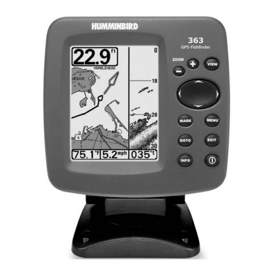
Page 7: What's On The Display
531448-1_A - 363_Man_Eng.qxd 11/9/2005 6:06 PM Page 12 What’s On the Display The 300 Series can display a variety of useful information about the area under and adjacent to your boat, including the following items: Depth - water depth; can be set to alarm when the Cursor - available in Freeze Frame and can be positioned in the Sonar View to provide depth of water becomes too shallow. -
Page 8: Views
531448-1_A - 363_Man_Eng.qxd 11/9/2005 6:06 PM Page 14 Views Sonar View The views available on your 300 Series Fishing System are: Sonar View presents a historical log of sonar returns. Depth is always displayed. Readouts for temperature and speed are automatically displayed if the appropriate Sonar views: Navigation views: accessory is connected. -
Page 9: Understanding Sonar History
531448-1_A - 363_Man_Eng.qxd 11/9/2005 6:06 PM Page 16 Understanding Sonar History Freeze Frame It is important to understand the significance of Freeze Frame - Pressing any arrow on the 4-WAY Cursor Control key will freeze the the 300 Series Fishing System display. The screen and a cursor will be displayed on the screen. -
Page 10: Sonar Zoom View
531448-1_A - 363_Man_Eng.qxd 11/9/2005 6:06 PM Page 18 Inverse is a method where weak returns are shown Sonar Zoom View with dark pixels and strong returns with lighter pixels. Sonar Zoom View increases the displayed resolution to separate sonar returns that This has the benefit of ensuring that weak signals will are very close together, such as those caused by fish suspended close to the bottom be clearly visible on the display. -
Page 11: 200/83 Khz Split Sonar View
531448-1_A - 363_Man_Eng.qxd 11/9/2005 6:07 PM Page 20 200/83 kHz Split Sonar View Big Digits View Split Sonar View displays sonar returns from the 83 kHz wide beam on the left side of Big Digits View provides digital data in a large, easy-to-see format. Depth is always the screen and displays sonar returns from the 200 kHz narrow beam on the right side displayed. -
Page 12: Bird's Eye View
531448-1_A - 363_Man_Eng.qxd 11/9/2005 6:07 PM Page 22 Bird’s Eye View Chart View Bird's Eye View - This view shows a 3-D, perspective view of the track and the chart’s Chart View - This view shows cartography from the built-in Uni-Map for the area land contour from a point above and behind the boat (the eye point). -
Page 13: Combo View
531448-1_A - 363_Man_Eng.qxd 11/9/2005 6:07 PM Page 24 Combo View Viewing Cartography Combo View - This view is displayed as a split screen, with Chart View on the left In the Chart or Combo Views there are several cartography-related functions that you and Sonar View on the right side of the screen. -
Page 14: Waypoints, Routes And Tracks
531448-1_A - 363_Man_Eng.qxd 11/9/2005 6:07 PM Page 26 Waypoints, Routes and Tracks Save, Edit, or Delete a Waypoint Waypoints are stored positions that allow you to mark areas of interest or navigation Save your current position as a waypoint: On any view, press the MARK key to save the points. -
Page 15: Navigate To A Waypoint Or Position
531448-1_A - 363_Man_Eng.qxd 11/9/2005 6:07 PM Page 28 To make it easier to select a waypoint, select Sort By and press the RIGHT or LEFT Cursor Add a Waypoint Target or Trolling Grid keys to select a sort order: Waypoint Target Add or Remove a Waypoint Target: From the Waypoints submenu, select Target and press the •... -
Page 16: Save, Edit Or Delete A Route
531448-1_A - 363_Man_Eng.qxd 11/9/2005 6:07 PM Page 30 Save, Edit or Delete a Route Save or Clear a Current Track Save the current route: While you are navigating, the current route can be saved. From Save the current track: From the Navigation X-Press menu, select Save Current Track the Navigation X-Press menu, select Save Current Route and press the RIGHT Cursor... -
Page 17: Key Functions
531448-1_A - 363_Man_Eng.qxd 11/9/2005 6:07 PM Page 32 Key Functions MENU Key Your 300 Series Fishing System user interface consists of a set of easy-to-use keys that The MENU key is used to access the menu system. work with various on-screen views and menus to give you flexibility and control over your fishing experience. -
Page 18: Mark Key
If the Cursor is not active, pressing the GOTO key displays the list of waypoints, so that 363 Title Screen you can select the waypoint towards which you want to navigate. ZOOM (+/-) Key... -
Page 19: Start-Up Options Menu
531448-1_A - 363_Man_Eng.qxd 11/9/2005 6:07 PM Page 36 Press the MENU key twice for the Main Menu, then use the Total Screen Update - when you change any menu settings that affect the Sonar 4-WAY Cursor LEFT or RIGHT key to select a tab, and use the View, the view will update immediately (i.e. -
Page 20: Simulator
531448-1_A - 363_Man_Eng.qxd 11/9/2005 6:07 PM Page 38 Simulator Self Test Use the Simulator to learn how to use your 300 Self Test displays results from the internal diagnostic Series Fishing System before taking your boat on self test, including unit serial number, Printed Circuit the water. -
Page 21: Gps Diagnostic View
531448-1_A - 363_Man_Eng.qxd 11/9/2005 6:07 PM Page 40 GPS Diagnostic View Sonar X-Press Menu (Sonar views only) GPS Diagnostic View shows a sky chart and numerical data from the GPS receiver. The sky chart shows the location of each visible GPS satellite with its satellite number and The Sonar X-Press menu provides access to the settings a signal strength bar. -
Page 22: Sensitivity
531448-1_A - 363_Man_Eng.qxd 11/9/2005 6:07 PM Page 42 Sensitivity Upper Range (Advanced: Sonar, Split Sonar, Big Digits Sensitivity controls how much detail is shown on the and Circular Flasher views only) display and will adjust the sensitivity of all sonar frequencies. Increasing the sensitivity shows more sonar returns from small baitfish and suspended debris in the water;... -
Page 23: Lower Range
531448-1_A - 363_Man_Eng.qxd 11/9/2005 6:07 PM Page 44 Lower Range Chart Speed Lower Range sets the deepest depth range that will be Chart Speed determines the speed at which the sonar displayed. Automatic is the default setting. When in automatic mode, the lower range information moves across the display, and consequently the amount of detail shown. -
Page 24: Bottom Range
531448-1_A - 363_Man_Eng.qxd 11/9/2005 6:07 PM Page 46 Bottom Range Cancel Navigation (Sonar Zoom view only when Bottom Lock is On) (only when Navigating) Bottom Range allows you to control how much of the water column, measured up Cancel Navigation discards the current route and exits Navigation Mode. This menu from the bottom, is shown in the Sonar Zoom View. -
Page 25: Navigation X-Press
531448-1_A - 363_Man_Eng.qxd 11/9/2005 6:07 PM Page 48 Navigation X-Press Menu Waypoint [Name] (Navigation views only) (Only with an active cursor on a waypoint) The Navigation X-Press menu provides access to the Waypoint [Name] allows you to view the Waypoints submenu for the waypoint under settings most frequently used. -
Page 26: Cursor To Waypoint
531448-1_A - 363_Man_Eng.qxd 11/9/2005 6:07 PM Page 50 Cursor to Waypoint Save Current Route (Chart or Combo view only) (only when Navigating) Cursor to Waypoint allows you to quickly move the cursor to any saved waypoint, so Save Current Route allows you to save the current route being displayed. This menu that you can locate it or edit it. -
Page 27: Cancel Navigation
531448-1_A - 363_Man_Eng.qxd 11/9/2005 6:07 PM Page 52 Cancel Navigation Remove Grid (only when Navigating) (only if a Grid is Active) Cancel Navigation discards the current route and exits Navigation Mode. This menu Remove Grid removes the waypoint grid from the display. This menu choice will only choice will only appear when you are currently navigating a route. -
Page 28: Waypoint [Name]
531448-1_A - 363_Man_Eng.qxd 11/9/2005 6:07 PM Page 54 Waypoint [Name] Sonar Menu Tab (Most recently-created waypoint) Press the MENU key twice to access the Main Menu System and then press the RIGHT Cursor key to select the Waypoint [Name] allows you to view the waypoints submenu for the most recently Sonar tab. -
Page 29: Beam Select
531448-1_A - 363_Man_Eng.qxd 11/9/2005 6:07 PM Page 56 Beam Select Fish ID+ Beam Select sets which sonar returns from the Fish ID+ uses advanced signal processing to interpret transducer will be displayed on the screen. sonar returns, and will display a Fish Symbol when very selective requirements are met. When a fish is detected, a fish icon and its depth are displayed above the return that has When set to 200/83 kHz, the returns from both beams are blended by starting with the been classified as being a fish. -
Page 30: Fish Id Sensitivity
531448-1_A - 363_Man_Eng.qxd 11/9/2005 6:07 PM Page 58 Fish ID Sensitivity Zoom Width Fish ID Sensitivity adjusts the threshold of the Fish Zoom Width adjusts the width of the Zoom window on detection algorithms. Selecting a higher setting allows weaker returns to be the Sonar Zoom View. -
Page 31: Depth Lines
531448-1_A - 363_Man_Eng.qxd 11/9/2005 6:07 PM Page 60 Depth Lines Surface Clutter (Advanced) (Advanced) Depth Lines divide the display into four equal sections that are separated by three Surface Clutter adjusts the filter that removes surface clutter noise caused by algae and horizontal depth lines. -
Page 32: Noise Filter
531448-1_A - 363_Man_Eng.qxd 11/9/2005 6:07 PM Page 62 Noise Filter Water Type (Advanced) (Advanced) Noise Filter adjusts the sonar Noise Filter to limit interference on the display from Water Type configures your unit for operation in fresh or salt water. The Water Type sources such as your boat engine, turbulence, or other sonar devices. -
Page 33: Navigation Menu Tab
531448-1_A - 363_Man_Eng.qxd 11/9/2005 6:07 PM Page 64 Navigation Menu Tab Current Track Press the MENU key twice to access the Main Menu Current Track allows you to view the Current Track System, then press the RIGHT cursor key to select the submenu. -
Page 34: Saved Tracks
531448-1_A - 363_Man_Eng.qxd 11/9/2005 6:07 PM Page 66 Saved Tracks Waypoints Saved Tracks allows you to view the Saved Tracks Waypoints allows you to view the Waypoints submenu. submenu. To view the Saved Tracks Submenu: To view the Waypoints Submenu: 1. -
Page 35: Routes
531448-1_A - 363_Man_Eng.qxd 11/9/2005 6:07 PM Page 68 Routes Chart Orientation Routes allows you to view the Routes submenu. Chart Orientation allows you to select whether the Chart and Combo Views should be drawn North-Up or Course-Up. To view the Routes Submenu: To change the Chart Orientation setting: 1. -
Page 36: Trackpoint Interval
531448-1_A - 363_Man_Eng.qxd 11/9/2005 6:07 PM Page 70 Trackpoint Interval Map Datum (Advanced) Trackpoint Interval allows you to select the time period between trackpoints. The current track can only contain up to 20,000 Map Datum allows you to change the map coordinate system used by the 300 Series trackpoints, so longer time periods cause the track to extend back further in time, Fishing System to match those of a paper map. -
Page 37: Course Projection Line
531448-1_A - 363_Man_Eng.qxd 11/9/2005 6:07 PM Page 72 Course Projection Line Chart Menu Tab Course Projection Line allows you to display or hide an Press the MENU key twice to access the Main Menu arrow extending from the bow of the boat that projects your current course, and shows System and then press the RIGHT Cursor key to select where the boat will go if you continue on your present course. -
Page 38: Chart Detail Level
531448-1_A - 363_Man_Eng.qxd 11/9/2005 6:07 PM Page 74 Chart Detail Level To change the Map Borders setting: 1. Highlight Map Borders on the Chart main menu. Chart Detail Level allows you to select how much chart detail you want displayed on the Navigation Views. Basic shows land areas, ports, 2. -
Page 39: Set Map Offset
531448-1_A - 363_Man_Eng.qxd 11/9/2005 6:07 PM Page 76 Set Map Offset Alarms Menu Tab (Advanced) From any view, press the MENU key twice to access the Main Menu System. The Alarms tab will be the default Set Map Offset allows you to change the map offset used by the 300 Series . -
Page 40: Depth Alarm
531448-1_A - 363_Man_Eng.qxd 11/9/2005 6:07 PM Page 78 Depth Alarm Low Battery Alarm Depth Alarm sounds when the depth becomes equal to Low Battery Alarm sounds when the input battery or less than the menu setting. voltage is equal to or less than the menu setting. The battery alarm will only sound for the battery that is connected to the 300 Series Fishing System. -
Page 41: Off Course Alarm
531448-1_A - 363_Man_Eng.qxd 11/9/2005 6:07 PM Page 80 Off Course Alarm Drift Alarm Off Course Alarm sounds when the boat has moved Drift Alarm sounds when the boat has exceeded the too far off course based on the menu setting when navigating. Off Course Alarm distance from the boat’s anchored position, based on the menu setting. -
Page 42: Setup Menu Tab
531448-1_A - 363_Man_Eng.qxd 11/9/2005 6:07 PM Page 82 Setup Menu Tab Units - Depth From any view, press the MENU key twice to access the Units - Depth selects the units of measure for all depth- tabbed Main Menu System, then press the RIGHT cursor related readouts. -
Page 43: Units - Speed
531448-1_A - 363_Man_Eng.qxd 11/9/2005 6:07 PM Page 84 Units - Speed Triplog Reset Units - Speed selects the units of measure for speed- Triplog Reset resets the Triplog to zero, and will appear in related readouts, and will appear in the menu if a Temp/Speed Accessory is connected the menu if a Temp/Speed Accessory is connected and the and the paddlewheel has moved at least once, or if the GPS Receiver is connected. -
Page 44: Select Readouts
531448-1_A - 363_Man_Eng.qxd 11/9/2005 6:07 PM Page 86 Select Readouts To Select Readouts: (Advanced, Sonar view only) 1. Make sure you are in Advanced User Mode, then highlight Select Readouts on the Setup main menu. Select Readouts sets individual digital readouts on the Sonar View. -
Page 45: Speed Calibration
531448-1_A - 363_Man_Eng.qxd 11/9/2005 6:07 PM Page 88 Speed Calibration Daylight Saving Time (Advanced, with Temp/Speed only) (Advanced) Speed Calibration will adjust the speed readout by the percentage entered, and will Daylight Saving Time adjusts the time display to account for local Daylight Saving Time appear in the menu if a Temp/Speed Accessory is connected and the paddlewheel when Time+Date is selected as a Digital Readout on the Sonar View (see Select has moved at least once, when the unit is in Advanced User Mode (see Setup Menu... -
Page 46: Time Format
531448-1_A - 363_Man_Eng.qxd 11/9/2005 6:07 PM Page 90 Time Format NMEA Output (Advanced, International only) (Advanced) Time Format changes the time format used by the unit This menu choice is available NMEA Output turns the NMEA* output on or off. This menu choice is available only only when in Advanced User Mode (see Setup Menu Tab: User Mode). -
Page 47: Sonar
531448-1_A - 363_Man_Eng.qxd 11/9/2005 6:07 PM Page 92 Sonar Views Menu Tab Sonar deactivates Sonar and removes the Sonar Views From any view, press the MENU key twice to access the from the view rotation. (Off, On, Default = On) tabbed Main Menu System, then press the RIGHT 4-WAY Cursor Control key until the Views tab is selected. -
Page 48: Troubleshooting
Page 94 Troubleshooting Display Problems Before contacting the Humminbird® Customer Resource Center, please read the There are several main conditions or sources of possible interference that may cause following section. Taking the time to review these troubleshooting guidelines may problems with the quality of the information displayed on the control head. Look in the... - Page 49 15” (38 cm) from the propeller, and that the water flows smoothly over the face of the transducer at all times. NOTE: Humminbird® verifies maximum stated depth in saltwater conditions, but actual depth performance may vary due to transducer installation, water type, thermal layers, bottom composition and slope.
- Page 50 Big Digits View also shows the TripLog. See TripLog. sonar return. See dB Down Point. Bottom Black: Bottom Black is a Humminbird® feature that "fills in" the area of the dB Down Point: The dB Down Point is the standard decibel level at which the sonar display below the bottom contour.
- Page 51 ID+ determines that a sonar return is likely to be a fish. See Fish ID+ Humminbird® units can operate across a very broad depth range (up to 2500 feet) which causes the unit to "look" up to that full depth under some circumstances. Due to the speed Freeze Frame: Freeze Frame is a Humminbird®...
- Page 52 Real Time Sonar: Real Time Sonar is a Humminbird® technology that delivers ultra- representing a smaller area and thus providing more detail. In fishfinders, vertical...
- Page 53 100 feet of depth. Target separation decreases as depth increases and structure. Many Humminbird® units operate at up to 40 times per second when due to the need for longer Pulse Width to achieve greater depth. See Pulse Width.
- Page 54 "dynamic range" which provides the ability to receive very strong Humminbird® offers One-Touch® Zoom which allows the zoom feature to be easily signals alternating with very weak signals, without the strong signal overwhelming the accessed from the regular sonar view with just one key press, eliminating the need to weak signal.
- Page 55 Cold Start: Cold Start refers to the procedure that a GPS receiver must perform when second. A GPS receiver, such as that included with many Humminbird® products, it does not have historical information regarding its current location. This procedure...
- Page 56 DoD reserves the right to activate SA at any time. Mean Time (GMT)). To display the correct Local Time in a Humminbird® GPS unit, the user must use the Local Time Zone menu and select the time zone (i.e. EST, CST).
- Page 57 GPS receiver’s memory. This can include a marker buoy, dock, fishing hole or anywhere else the user may want to return to. Humminbird® products offer the ability to name and assign a symbol to the saved location. Depth, 1-800-633-1468 Date and Time of Day when the waypoint was created is also saved.
Need help?
Do you have a question about the 363 and is the answer not in the manual?
Questions and answers