Garmin GPSMAP 78 Owner's Manual
Gpsmap 78 series
Hide thumbs
Also See for GPSMAP 78:
- Owner's manual (48 pages) ,
- Quick start manual (36 pages) ,
- Safety and product information (40 pages)

Subscribe to Our Youtube Channel
Related Manuals for Garmin GPSMAP 78


Summary of Contents for Garmin GPSMAP 78
- Page 1 GPSMAP 78 series ® owner’s manual for use with the GPSMAP 78, GPSMAP 78S, and GPSMAP 78Sc...
- Page 2 Visit the Garmin Web site (www.garmin.com) for current updates and supplemental information concerning the use and operation of this and other Garmin products. Garmin (Europe) Ltd. Liberty House,...
-
Page 3: Table Of Contents
Table of Contents Getting Started ... Manual Conventions ... Device Overview... Battery Information ... Installing the Batteries ... Turning the Device On or Off ... Acquiring Satellite Signals ... Buttons ... Navigating with Waypoints and Routes ... Waypoints ... Routes ... Additional Maps ... - Page 4 Fitness ... Profiles... Appendix ... Registering Your Device ... Updating the Software ... Viewing Important Device Information ... Contacting Garmin Product Support ... Using the Backlight ... Specifications ... Maximizing Battery Life ... About the Batteries ... Buying Optional Accessories ...
-
Page 5: Getting Started
5. Navigate a route (page 6. Record a track (page 7. Calibrate the compass GPSMAP 78 Series Owner’s Manual Manual Conventions When you are instructed to press something, use the buttons on the unit. Use the Rocker to select something in a list, and then press ENTER. -
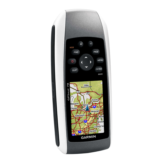
Page 6: Device Overview
Device Overview Internal antenna Buttons Display MCX connector for external GPS antenna (under weather cap) GPSMAP 78 Series Owner’s Manual Serial port (under weather cap) mini-USB port (under weather cap) Battery compartment microSD ™ card slot (under batteries) -
Page 7: Battery Information
For best results, after you install new batteries, update the battery type in the system settings (page 37). GPSMAP 78 Series Owner’s Manual Turning the Device On or Press and hold Setting Your Language 1. Turn on the unit. 2. Use the Rocker to select a... -
Page 8: Acquiring Satellite Signals
Press and hold MOB (man overboard function) to store your current location as a waypoint and begin navigation to that point. Press and hold turn the device on and off. Quickly press open the backlight status page. GPSMAP 78 Series Owner’s Manual... - Page 9 MARK options and acknowledge messages. Press and hold MARK to save your current location as a waypoint. GPSMAP 78 Series Owner’s Manual Rocker Press up, down, right, and left to select menu options and to move the map cursor. Press + to zoom in on the map.
-
Page 10: Navigating With Waypoints And Routes
3. Select an attribute (such as the name or location). 4. Enter the new information. 5. Select Done. Deleting a Waypoint 1. From the main menu, select Waypoint Manager. 2. Select a waypoint. 3. Press MENu. 4. Select Delete. GPSMAP 78 Series Owner’s Manual... -
Page 11: Routes
6. Repeat steps 2–5 until the route is complete. A route must contain at least two points. 7. Press quIT to save the route. GPSMAP 78 Series Owner’s Manual Editing the Name of a Route 1. From the main menu, select Route Planner. 2. Select a route. -
Page 12: Viewing The Active Route
2. Select Stop Navigation. Navigating a Reverse Route 1. From the main menu, select Route Planner. 2. Select a route. 3. Select Reverse Route. 4. Select the route again. 5. Select View Map. 6. Select Go. GPSMAP 78 Series Owner’s Manual... -
Page 13: Additional Maps
4. Enter the city or postal code. NOTE: Not all map data provides postal code searching. 5. Select the city. GPSMAP 78 Series Owner’s Manual 6. Enter the house number. 7. Enter the street. 8. Select Go. Finding Marine Services with... -
Page 14: Tracks
Tracks About Tracks Your Garmin device records a track log while you are moving. You can save these tracks and navigate to them later. You can view archived or loaded tracks by selecting Track Manager from the main menu. Managing Track Log Recording 1. -
Page 15: Navigating A Saved Track
• Save Portion—allows you to select a portion of the current track to save. GPSMAP 78 Series Owner’s Manual Clearing the Current Track From the main menu, select Setup > Reset > Clear Current Track > Yes. Deleting a Track 1. -
Page 16: Using The Main Pages
• Select Track up to show your current direction of travel at the top of the page. Select Automotive Mode to • show a perspective view. GPSMAP 78 Series Owner’s Manual position icon represents your... -
Page 17: Measuring Distance
From the map, press MENu, and select Setup Map. • Map Orientation—allows you to select how the map is displayed (page 12). GPSMAP 78 Series Owner’s Manual • Guidance Text—allows you to select when to show guidance text on the map. • Advanced Map Setup Auto Zoom—automatically... -
Page 18: Compass
GPSMAP 78Sc. You should calibrate the compass after moving long distances, experiencing temperature changes, or changing the batteries. 1. From the compass, press MENu. 2. Select Calibrate Compass > Start. 3. Follow the on-screen instructions. notice GPSMAP 78 Series Owner’s Manual... -
Page 19: Using The Compass
1. From the main menu, select Sight ‘N Go. 2. Point the device at an object. 3. Select Lock Direction > Set Course. GPSMAP 78 Series Owner’s Manual 4. Use the compass to navigate to the object. Compass Setup Options From the compass, press MENu, and select Setup Heading. -
Page 20: Elevation Plot
You can manually calibrate the barometric altimeter if you know the correct elevation or the correct pressure. 1. From the elevation plot, press MENu. 2. Select Calibrate Altimeter. 3. Follow the on-screen instructions. (page 14). GPSMAP 78 Series Owner’s Manual... -
Page 21: Opening The Main Menu
◦ ambient pressure changes over a period of time. • Adjust Zoom Ranges—adjusts the zoom ranges shown on the elevation plot page. GPSMAP 78 Series Owner’s Manual • Reset—resets the elevation plot data: ◦ Reset Trip Data—resets all trip data. -
Page 22: Trip Computer
• Change Dashboard—changes the theme and information displayed on the dashboard. NOTE: Your customized settings are remembered by the dashboard, and will not be lost when you change profiles (page GPSMAP 78 Series Owner’s Manual 20). -
Page 23: Main Menu Features And Settings
35). Your device can send or receive data when connected to another compatible device. You must be within 10 feet (3 m) of the compatible Garmin device. Sending and Receiving Data 1. From the main menu, select Share Wirelessly. 2. Select Send or Receive. -
Page 24: Proximity Alarms
2. Walk around the perimeter of the area you want to calculate. 3. Select Calculate when finished. After you calculate the area, you can save the track to your device and change the unit of measure. page GPSMAP 78 Series Owner’s Manual... -
Page 25: Satellite
• Single Color—allows you to select whether the satellite page is displayed in multicolor or single color. GPSMAP 78 Series Owner’s Manual • Set Location On Map—allows you to mark your current location on the map. This option is available only when you turn off GPS. - Page 26 Stopwatch—allows you to use a • timer, mark a lap, and time laps. Waypoint Averaging—allows you • to refine a waypoint location with multiple samples to achieve the most-accurate location possible. GPSMAP 78 Series Owner’s Manual...
-
Page 27: Customizing Your Device
Description Accuracy of GPS The margin of error for your exact location. For example, your GPS location is accurate to within +/- 12 feet. GPSMAP 78 Series Owner’s Manual Data Field Description **Ambient The uncalibrated Pressure environmental pressure. **Ascent -... - Page 28 The glide ratio required to descend from your current position and elevation to the destination elevation. The strength of the GPS signal. The direction you are moving. Your heart rate in beats per minute (bpm). GPSMAP 78 Series Owner’s Manual...
- Page 29 Speed The current rate of speed at which you are moving since last reset. GPSMAP 78 Series Owner’s Manual Data Field Description Speed - Maximum The maximum speed reached since last reset. Speed - Moving The average speed Avg.
- Page 30 Vertical Speed Your rate of altitude gain or loss over time. Waypoint at Dest. The last point on a route to your destination. Waypoint at Next The next point on your route. GPSMAP 78 Series Owner’s Manual...
-
Page 31: System Settings
Battery Type—allows you to select the type of battery you are using. • Interface—sets the format of the serial interface: GPSMAP 78 Series Owner’s Manual ◦ Garmin Serial—Garmin proprietary format used to exchange waypoint, route, and track data with a computer. -
Page 32: Display Settings
• Screen Capture—allows you to take screen captures on the device. Setting Up Tones Your Garmin device allows you to customize the key tones, message beeps, or turn off tones. From the main menu, select Setup > Tones. Marine Settings From the main menu, select Setup >... -
Page 33: Setting Up Marine Alarms
Marine Alarm Setup—sets the anchor drag alarm, off course alarm, deep water alarm, and shallow water alarm. GPSMAP 78 Series Owner’s Manual Setting up Marine Alarms Setting the Anchor Drag Alarm You can set an alarm to sound when you exceed a specified drift distance while anchored. -
Page 34: Resetting Data
2. Select an item to reset. Changing the Page Sequence 1. From the main menu, select Setup > Page Sequence. 2. Select a page. 3. Select Move. 4. Move the page up or down the list. 5. Press ENTER. GPSMAP 78 Series Owner’s Manual... -
Page 35: Customizing The Unit Settings
1. From the main menu, select Setup > units. 2. Select a setting. 3. Select a unit for the setting. GPSMAP 78 Series Owner’s Manual 4. Repeat steps 2–3 for each setting you want to customize. Time Settings From the main menu, select Setup >... -
Page 36: Altimeter Settings
Plot Type • ◦ Elevation/Time—records elevation changes over a period of time. Elevation/Distance—records ◦ elevation changes over a distance. Barometric Pressure—records ◦ barometric pressure over a period of time. GPSMAP 78 Series Owner’s Manual... -
Page 37: Geocache Settings
Guidance Method—allows you to select a guidance method for calculating your route. Off Road—calculates point-to- ◦ point routes. GPSMAP 78 Series Owner’s Manual On Road For Time—calculates ◦ on-road routes that require minimal time to drive. ◦ On Road For Distance—... -
Page 38: Fitness
3. Select Edit Name. 4. Enter the new name. 5. Select Done. Deleting a Profile 1. From the main menu, select Setup 2. Select a profile. 3. Select Delete. page > Profiles. > Profiles. > Profiles. GPSMAP 78 Series Owner’s Manual... -
Page 39: Appendix
/products/webupdater. 2. Follow the on-screen instructions. NOTE: This does not erase any of your data or settings. GPSMAP 78 Series Owner’s Manual Viewing Important Device Information You can view the unit ID, software version, and license agreement. From the main menu, select Setup >... -
Page 40: Using The Backlight
Computer USB and serial interface Battery type Two AA batteries (alkaline, NiMH, or lithium) page Battery life Up to 20 hours, typical usage Operating From 5°F to 158°F temperature (from -15 to 70°C) range page GPSMAP 78 Series Owner’s Manual... -
Page 41: Maximizing Battery Life
The three-axis compass is available only with the GPSMAP 78S and GPSMAP 78Sc. GPSMAP 78 Series Owner’s Manual Maximizing Battery Life Using the Battery Save Option Use the battery save option to save battery power and prolong battery life. From the main menu, select Setup >... -
Page 42: About The Batteries
Stored data is not lost when batteries are removed. Buying Optional Accessories Go to http://buy.garmin.com, or contact your Garmin dealer for information about optional accessories, preloaded map data cards, fitness accessories, and replacement parts. GPSMAP 78 Series Owner’s Manual... -
Page 43: Using Optional Fitness Accessories
1. Bring the device within range (3 m) of the ANT+ accessory. 2. From the main menu, select Setup > Fitness. GPSMAP 78 Series Owner’s Manual 3. Select an option: • Select Heart Rate Monitor > •... -
Page 44: Data Management
ANT+ accessory each time it is activated. This process occurs automatically when you turn on the Garmin device and only takes a few seconds when the accessories are activated and functioning correctly. • When paired, your Garmin device... -
Page 45: Connecting The Usb Cable
4. Push in and slide up the metal cover. 5. Replace the batteries and the battery cover. GPSMAP 78 Series Owner’s Manual Removing a microSD Card 1. Slide down and pull out the metal cover. 2. Remove the card from the slot. -
Page 46: Transferring Files To Your Computer
1. Browse your computer for the file. microSD 2. Select the file. card slot 3. Select Edit > Copy. (inside battery 4. Open the “Garmin” or memory card compartment) drive/volume. 5. Select Edit > Paste. GPSMAP 78 Series Owner’s Manual... -
Page 47: Deleting Files
Before you can delete files, you must connect the device to your computer (page 40). 1. Open the “Garmin” drive or volume. 2. If necessary, open a folder or volume. 3. Select the files. 4. Press the Delete key on your keyboard. -
Page 48: Caring For The Device
Cleaning the Screen 1. Use a soft, clean, lint-free cloth. 2. If necessary, use water, isopropyl alcohol, or eyeglass lens cleaner. 3. Apply the liquid to the cloth, and gently wipe the screen with the cloth. GPSMAP 78 Series Owner’s Manual... -
Page 49: Troubleshooting
3. Remain stationary for several minutes. Decrease the backlight settings On the device, a screen appears showing the Garmin logo and the USB symbol. On your computer, you should see a new removable disk drive in My Computer on Windows computers and a mounted volume on Mac computers. - Page 50 If you have several network drives mapped on your computer, Windows may have trouble assigning drive letters to your Garmin drives. See the Help file for your operating system to learn how to assign drive letters. Go to http://buy.garmin.com, or contact your Garmin dealer.
-
Page 51: Index
ANT+ accessories area calculation AutoLocate backlight 4, 36, BaseCamp batteries 23, 27, GPSMAP 78 Series Owner’s Manual about information installing maximizing life selecting the type storage warnings beeps buttons calculator calendar calibrating... - Page 52 3, main menu settings man overboard changing orientation datum detail information GPSMAP 78 Series Owner’s Manual measuring distance setup options showing tracks viewing routes map datum coordinate system marine settings 28–29 MARK button MCX connector...
- Page 53 QUIT button recording tracks registering your device reset current track data defaults trip data GPSMAP 78 Series Owner’s Manual waypoints restoring default settings Rocker routes active route avoidance creating deleting editing editing name guidance method...
- Page 54 USB wirelessly trip computer troubleshooting unit ID updating software USB cable connecting disconnecting waypoints averaging creating deleting editting navigating to wrist strap zooming 5, zoom ranges GPSMAP 78 Series Owner’s Manual...
- Page 56 For the latest free software updates (excluding map data) throughout the life of your Garmin products, visit the Garmin Web site at www.garmin.com. © 2010 Garmin Ltd. or its subsidiaries Garmin International, Inc. 1200 East 151 Street, Olathe, Kansas 66062, USA Garmin (Europe) Ltd.
Need help?
Do you have a question about the GPSMAP 78 and is the answer not in the manual?
Questions and answers