Table of Contents
Advertisement
Quick Links
Advertisement
Chapters
Table of Contents

Related Manuals for Clarion NX702


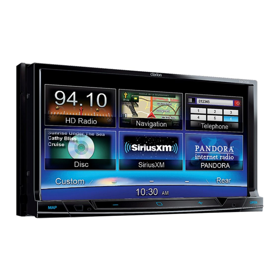
Summary of Contents for Clarion NX702
- Page 5 Turning the Power On Source Media Modes When you select the des1red source mode (for example, the DVD Video, USB or 1Pod mode). Start the engine. The power is supplied to the following screen will appear. this unit. Dunng playback, touch the bottom half of screen to show operation bar DVD Video mode Play/...
- Page 12 Installation Guide Installation Guide Installing The GPS Antenna Wire Connection • Be sure to connect SiriusXM cable • Do not Install the GPS antenna In a place where It may Interfere with the operation of the ~~~~:~:i~~crophone -JIJ properly. Mistakenly connect to SiriusXM alrbag or hinder the driver's visual range.
- Page 15 NX702 DVD MULTIMEDIA STATION WITH BUILT-IN NAVIGATION & 7" TOUCH PANEL CONTROL...
- Page 16 NX702...
-
Page 17: Table Of Contents
Contents Thank you for purchasing this Clarion product. place. manual. 1. FEATURES ........................3 Expanding Systems ......................3 2. PRECAUTIONS ......................... 4 3. CAUTIONS ON HANDLING ....................6 Front Panel / Generalities ....................6 Cleaning the body ......................6 USB Port ........................... 6 SD Slot .......................... -
Page 18: Features
1. FEATURES ® Tagging Expanding Systems Rear Rear Vision Monitor Camera ® ® iPod / iPhone ® Bluetooth SD Card Notes: NX702... -
Page 19: Precautions
Use of this copyright protection technology must be prohibited. copyright protection process has been applied. The Bluetooth ® Inc. and any use of such marks by Clarion Co.,Ltd, is under license. 11. © Clear Channel Broadcasting Inc. See Clarion.com for service terms and conditions. NX702... - Page 20 modify, copy, scan or use any other method to reproduce, duplicate, republish, transmit defend and hold harmless Inrix, Inc. and Clear Channel Broadcasting, Inc. (and its or speed. 12-3. THE LICENSED MATERIAL IS PROVIDED TO LICENSEE “AS IS” AND “WHERE IS”. OR REPRESENTATIONS WITH RESPECT TO THE LICENSED MATERIAL (INCLUDING WITHOUT LIMITATION, THAT THE LICENSED MATERIAL WILL BE ERROR-FREE, WILL OPERATE WITHOUT INTERRUPTION OR THAT THE TRAFFIC...
-
Page 21: Cautions On Handling
3. CAUTIONS ON HANDLING Front Panel / Generalities internal circuitry. sunlight. Cleaning the body long periods of time may cause stains. USB Port Some models may not operate correctly. before using a personal computer etc. When affected static electricity or electric noise. SD Slot personal computer etc. -
Page 22: Handling Discs
Handling Discs Handling Cleaning around the edges. If such discs are used, center of the disc to the circumference. skip. Use a ball-point pen or the like to remove any roughness from the edge of commercially available cleaners, anti-static spray, or thinner to clean discs. the disc. -
Page 23: Controls
4. CONTROLS Operational Panel [MAP PWR] [ + ] [OPEN/VR] [MENU ALL ] [MIC] RESET Short press [OPEN] button to slide down the panel. Front Side EJECT SD Card Slot Only navigation map card is available and don't NX702... -
Page 24: Names Of Buttons
Names of Buttons [MAP PWR] Knob [RESET] Button ignition on. mode. second to turn off the system. [OPEN/VR] Button [MENU ALL] Button panel. function. menu. ] EJECT Button [MIC] Hole Speaker Setting Mode 1. Select “Initial settings”, all speaker settings return to default setting. 3 Memory of previous speaker mode are deleted. -
Page 25: Remote Control
Remote Control [TAG] Button SiriusXM / HD Radio mode – Tagging [TITLE] Button [RPT] Button [ENT] Button [RDM] Button [ROOT] Button ] Buttons [SUB.T] Button [ANGLE] Button [SRC / ] Button [SEND/END] Button [OPEN] Button [MUTE] Button panel. Mute the volume [0]~[9] Button function. - Page 26 Remote Control / STOP] Button CAUTION children. ] Buttons a doctor immediately. RADIO / HD RADIO / DAB mode SiriusXM mode CAUTION DVD mode Previous/next chapter. CD/BLUETOOTH mode not used for a month or longer. Previous/next track. battery is incorrectly replaced. Replace [ZOOM] Button [AUDIO] Button tools.
-
Page 27: Main Menu Operation
5. MAIN MENU OPERATION Long press [ MENU ALL ] button on the Touch the icons on the screen to enter mode, USB mode, iPod mode, etc. Short press [ MENU Touch [ ] to turn off the rear zone Short cut menu. -
Page 28: System Setup
6. SYSTEM SETUP At all mode, long press [ MENU ALL ] Touch [ ] button. button to enter main source menu. Touch ] on the bottom left of the screen, then select [Settings] on the screen to enter Setting menu. Touch the icons on the left of Sound, Display or Setup. - Page 29 Blinking LED Touch [On] or [ ] to turn on/off the blinking LED. At blinking LED [On Touch [On] or [ ] to set the internal Touch [Version When select [Auto close automatically after 10 seconds. version. When select [Manual not close unless you touch the blank area on the screen.
- Page 30 Touch [ ] or [+] button on the right of Touch [Set] on the right to Speaker Gain. level. Store Settings Touch [Store] on the right to Store Setting, select Memory1, Memory2 or Memory3 to Reverse. store current settings. Touch the button to the right of “High pass Touch Memory1, Memory2 or Memory3 to recall corresponding settings.
- Page 31 Touch [Auto] to use ringtones of your is off. While interrupting no attenuate mobile phone. function of AV sound. Touch [Internal] to use preset ringtone of the unit. PANDORA PANDORA Select PANDORA On or Off. PANDORA application, please set on, else set off. Camera Choose [On Anti Theft...
-
Page 32: Disc Operation
7. DISC OPERATION DVD System Multi-story function When a DVD video contains more than one source that provides crisp and clear images. One 12 cm disc contains either one film or four hours of music. observe the instructions for selecting a story DVD Video Features provided during playback. - Page 33 sessions recorded cannot be played on this of numbers that also incorporate a “1”. DVD video player. The DVD video region number is marked on Note: About playing a CD-R/CD-RW disc (MP3, WMA) This player can play CD-R/CD-RW discs previously recorded in music CD format (MP3, About playing a DVD-R/RW or DVD+R/ RW disc This player cannot play DVD-R/RW and...
-
Page 34: Accessing A Disc
Accessing a Disc CAUTION Eject function Press [OPEN then press the [ Notes: Listening to a disc already loaded in the unit Long press [ MENU ALL ] button to enter main source menu, then select [ ] to enter Disc mode. If Disc is not on the current source menu, touch [ ] buttons on the bottom of the... -
Page 35: Dvd Player Operation
DVD Player Operation Playback menu 15. Turn on Widescreen mode 16. Direct search operation bar. 19. Mute indicator Pausing play 1. Touch the [ ] button on the screen to pause play. 2. Touch [ ] button to resume play. Selecting a chapter Touch the [ ] button to move to the... - Page 36 DVD subtitle select During playback, touch [ ], [Subtitle] buttons to select the subtitle language if the DVD has multiple language subtitles. Playback information During playback, touch [ ], [ Adjust picture During playback, touch [ ], [ Adjust ] button, then use [ ], [+] buttons to DVD angle select During playback, touch [ ], [ Angle ]...
-
Page 37: Cd Player Operation
CD Player Operation 2. Touch the [ Playback menu to the beginning of the previous track. Fast forward/Fast reverse Touch and hold the [ ] button . Touch and hold the [ ] button . * For MP3/WMA discs, it takes some time tracks. -
Page 38: Mp3/Wma Playback
MP3/WMA Playback This unit is an ID3 Tag compatible model. This unit supports the ID3 TAGs of the Version 2.4, 2.3, 1.1 and 1.0. or CD-RW disc, please select “ISO9660 level In displaying, this unit gives priority to the 1, 2 or Joliet or Romeo” or Apple ISO as the Version 2.3 and 2.4 TAGs. - Page 39 ♪ ① ♪ ② ♪ ③ ♪ ④ ♪ ⑤ ♪ ⑥ 10. Scan play ♪ 11. Rotate the album image ⑦ ♪ 12. Back to main operation bar ⑧ ○ Folder Select ♪ ♪ ⑨ Touch the [ ] button on the upper left of levels and does not display folders containing other folders.
-
Page 40: Mp4 Playback
MP4 Playback Playback menu When playing, touch the bottom half of Touch the [ ] button to move to the Touch the [ ] button to move back to the Fast forward/Fast reverse Hold the [ ] button . 1. Play/Pause Hold the [ ] button . -
Page 41: Sd/Usb Operation
8. SD/USB OPERATION Accessing an USB 1. Insert an USB device into the USB cable. When connecting an USB device, the unit 2. To remove the USB device, you should first select another source or turn off the USB device. Then take off the USB device. -
Page 42: Sd/Usb Audio Operation
SD/USB Audio Operation Select SD/USB Audio mode Touch top left corner of the screen until SD use it as an audio device by simply copying Audio or USB Audio appears. Operation about SD/USB audio is same as MP3/WMA playback mode. Notes: SD/USB Video Operation can use it as an video device by simply... -
Page 43: Bluetooth Operation
Bluetooth feature. This system can play audio data stored contacts, received call, dialled call, missed call, incoming calls, outgoing call and listen to music. Notes: Clarion Bluetooth Telephone Operation Pairing 5. If connect unsuccessfully, select [... -
Page 44: Making A Call
Call History. 1. Touch [ 2. Backspace 3. Paired device information Contacts. 4. Number pad Touch [Dialer] to dial number manually. 5. Call/Hang up 2. Touch to select a category, the numbers of the category are displayed. 3. Select a number, touch [ ] button to dial. -
Page 45: Bluetooth Audio Operation
2. Each time you touch the [ ] button, the track advances to the beginning of the consult your nearest Clarion dealer for more next track. streaming transmitter offered. 1. Touch the [ ] button to move back to the beginning of the current track. -
Page 46: Siriusxm Satellite Radio Operation
10. SiriusXM Satellite Radio OPERATION getting over 130 channels, including the most commercial-free music, plus the best Accessing satellite radio mode Long press [ ALL ] button to enter main source menu, then select [SiriusXM] to enter 11. Enter Replay mode SiriusXM mode. - Page 47 Activate the SiriusXM Vehicle Tuner using 3. Touch the option on the preset channel list to select corresponding stored station. O n l i n e Category and Channel search Phone 1. Touch [ ] button on the upper left of Select a band 2.
- Page 48 or Song. To remove it from the list, touch [Delete]. ] -> [ ] -> [ 3. When the memorized song/artist is broadcasted on another Channels. Alert Touch [ ] or [ ] button to scroll the list. dialog box is displayed. Select [OK] on the Touch [ ] to lock station, and [ ] to...
-
Page 49: Hd Radio Operation
11. HD Radio OPERATION About HD Radio™ Technology 11. Select next multicast digital broadcasting of your local AM and FM radio stations. HD Radio broadcasts can include multiple channels on the same multicasting, you can receive up to eight With an HD Radio tuner connected, you offers HD Radio Technology. - Page 50 Preset stations Up to six stations on each band can be Technology enables local radio stations to recalled by pressing the associated preset broadcast a clean digital signal. AM sounds button. NOTE: Multicast stations can be stored as presets, but the unit must be in Digital or Auto reception mode to receive them.
-
Page 51: Itunes Tagging
12. iTunes Tagging Table 5: TAG Messages Tag Message Reason Radio™ and SiriusXM stations for purchase Tagging Tag data is stored on the later through iTunes. When touch [Tag] Finished...##%100 unit. button, the unit stores the title and artist song Tagging... -
Page 52: Ipod & Iphone Operation
13. iPod & iPhone OPERATION Connect an iPod or iPhone to the USB connector via CCA-750 cable. display on the screen once playback start. 11. Turn on / off Simple Control 12. Select Audiobook play speed 13. Back to main operation bar CCA-750 Browse mode Accessing iPod mode... -
Page 53: Ipod Video Playback
1. Play/Pause Touch and hold the [ ] button . 2. Repeat play Repeat play 4. Progress bar repeatedly. Touch the [ ] button to select Repeat one or Repeat all. Random play random order. Touch the [ ] button to perform random play. -
Page 54: Pandora Operation
14. PANDORA OPERATION PANDORA, the leading internet radio service, gives people music they love 11. Back to main operation bar Add bookmark connected devices. Touch [ ] button, then select [ ] or To listen to PANDORA internet radio, you [Artist] to add it to the bookmark list. -
Page 55: Navigation Operation
15. NAVIGATION OPERATION Access navigation mode Control buttons 1. Press [OPEN panel. Insert a MicroSD card into the mini GPS informations. Touch [ ] to return. card slot located on the bottom of the 2. Touch bottom left corner of the screen panel. -
Page 56: Trouble Shooting
17. TROUBLE SHOOTING GENERAL Problem Cause Measure Unit fuse blown. Replace with new fuse of correct rating. Unit can not Car battery fuse blown. Replace with new fuse of correct rating. power on. Turn on the ACC RESET] Unit can not button with a thin rod. - Page 57 DISC Player Cause Measure Another disc is already loaded. Disc cannot be loaded. the unit. Disc is dirty. Sound skips or is noisy. scratches. Condensation may form on the in a humid place. The parking brake is not engaged. Check that the parking brake is engaged. Video images are not displayed.
- Page 58 Message Check the SiriusXM tuner connection on the back of the unit to ensure that its Check Tuner correctly connected. Ensure the SiriusXM antenna cable is connected to the SiriusXM tuner correctly. Check Antenna antenna if necessary. Load “Factory default” settings on Setting menu. If the message remains, the antenna may have been damaged.
-
Page 59: Error Displays
18. ERROR DISPLAYS Cause Measure Disc loading Disc is being read for some disc or storage device. Disc is dirty No Disc Disc not present in loading Insert disc compartment Disc is dirty Unsupported Disc Disc format is not compatible Change another disc. -
Page 60: Specifications
19. SPECIFICATIONS FM Tuner Bluetooth A2DP (Advanced Audio Distribution AM Tuner 30dBμ Disc Player (4 to 8 7 Inch TFT LCD MP3/WMA mode Input (input impedance 10 k General MP4,MPG/MPEG,3GP negative ground 480x272 Standard SD/SDHC, microSD/SDHC MP4,M4V 480x272 NX702... - Page 61 178mm 100mm 7" 4" Note: Signal to Noise Ratio: NX702...
-
Page 62: Wiring And Connections
20. WIRING AND CONNECTIONS GPS Antenna GPS Antenna (Black) External Microphone External Microphone Connection Connection (Black) Black properly. Mistakenly connect to SiriusXM cable may cause damage to your unit or the connected device. (Black) Radio Antenna Radio Antenna Refer to next page. Refer to the right. - Page 63 18-Pin Connector Extension Lead Gray Front Right /MID-R Gray/Black Connect to cellular phone mute lead. White Front Left /MID-L White/Black Purple Connect directly to battery Rear Right /HIGH-R Purple/Black Green Rear Left /HIGH-L Accessory Green/Black 4-Speaker system 2-Speaker system Gray Connect to vehicle chassis ground Front Right Gray/Black...
- Page 65 NX702 Navigation...
- Page 66 It is easy to keep the navigation system up to date. Simply download new map data from Clarion’s portal site, store them on a microSD card and insert it into the Clarion NX702 via the front card slot. Unpleasant surprises are now avoided as navigation maps will match the real world.
- Page 67 Table of contents 1. Warnings and Safety information ..................6 2. Getting started.......................... 7 2.1 Buttons and other controls on the screen ................... 8 2.1.1 Using keyboards............................9 2.1.2 Beyond single screen tap...........................10 2.2 Map screen ............................11 2.2.1 Navigating on the map ..........................11 2.2.2 Position markers............................13 2.2.2.1 Vehimarker and Lock-on-Road...........................
- Page 68 3.1.2.2 Searching for a Place of Interest using preset categories................... 45 3.1.2.3 Searching for a Place of Interest by category..................... 47 3.1.2.4 Searching for a Place of Interest by name ......................49 3.1.2.5 Searching for a Place of Interest by its Phone Number ..................52 3.1.2.6 Selecting nearby assistance from 'Where Am I?' ....................
- Page 69 5.1.6 Road safety cameras and other proximity alert points ................81 5.1.7 Speed limit warning ..........................82 5.1.8 Traffic information in route planning .......................82 5.2 'More' menu ............................84 5.3 Settings menu............................ 85 5.3.1 Sound and Warnings ..........................87 5.3.2 Customize Quick menu..........................89 5.3.3 Traffic settings ............................
-
Page 70: Warnings And Safety Information
It is important that you look at the display only when it is safe to do so. If you are the driver of the vehicle, we recommend that you operate Clarion Mobile Map before you start your journey. Plan the route before your departure and stop if you need to change the route. -
Page 71: Getting Started
2. Getting started Clarion Mobile Map is optimized for in-car use. You can use it easily by tapping the screen buttons and the map with your fingertips. When using the navigation software for the first time, an initial setup process starts automatically. Do as follows: Select the written language of the application interface. -
Page 72: Buttons And Other Controls On The Screen
The initial setup is now complete. The Configuration wizard can be restarted later from the Settings menu (page 85). After the initial setup, the Map screen appears and you can start using Clarion Mobile Map. 2.1 Buttons and other controls on the screen When you are using Clarion Mobile Map, you usually tap buttons on the touch screen. -
Page 73: Using Keyboards
When a feature can be set to Drag the handle to different values in a range, move the slider to its Clarion Mobile Map shows an new position. indicator on a gauge that Tap the slider where displays and sets the value. -
Page 74: Beyond Single Screen Tap
Entering numbers and symbols to switch to a keyboard offering numeric and symbol characters. Finalizing the keyboard entry (accepting the suggested search result) Finalizing the keyboard entry (opening the list of search results) Finalizing the keyboard entry (saving your input) Canceling the keyboard entry (returning to the previous screen) -
Page 75: Map Screen
Gestures (drag&drop) You need to drag and drop the screen only in cases like: Moving the handle on a slider. Scrolling the list: grab the list anywhere and slide your finger up or down. Depending on the speed of the sliding, the list will scroll fast or slow, only a bit or till the end. - Page 76 Shows the time needed to reach the final destination of the route based on information available for the remaining segments of the route. If Clarion NX702 is capable of receiving live traffic information, the calculation takes into account traffic delays affecting your route if they are received.
-
Page 77: Position Markers
2.2.3.1 Streets and roads Clarion Mobile Map shows the streets in a way that is similar to how the paper road maps show them. Their width and colors correspond to their importance: you can easily tell a freeway from a small street. -
Page 78: Turn Preview And Next Street
2.2.3.2 Turn preview and Next street When navigating a route, the top section of the Map screen shows information about the next route event (maneuver) and the next street or the next city/town. There is a field in the top left corner that displays the next maneuver. Both the type of the event (turn, traffic circle, exiting freeway, etc.) and its distance from the current position are displayed. -
Page 79: Lane Information And Signposts
When navigating on multi-lane roads, it is important to take the appropriate lane in order to follow the recommended route. If lane information is available in the map data, Clarion Mobile Map displays the lanes and their directions using small arrows at the bottom of the map. Highlighted arrows represent the lanes you need to take. -
Page 80: Junction View
2.2.3.4 Junction view If you are approaching a freeway exit or a complex intersection and the needed information exists, the map is replaced with a 3D view of the junction. The lanes you need to take are displayed with arrows. Signposts can also be present if information is available. -
Page 81: Object Types
3D block representation of full city building data containing actual building size and position on the map. 2.2.3.7 Elements of the active route Clarion Mobile Map shows the route in the following way: Current GPS position and Start Your current position displayed on the map. If roads are point near, it is aligned to the nearest road. -
Page 82: Traffic Events
2.2.3.8 Traffic events Road segments affected by traffic events are displayed with an alternate colour on the map, and small symbols above the road show the nature of the event: to open the Traffic Summary screen. to open the list of traffic events: Now tap any of the list items to see its details, and to display the affected road segment in its full length on the map: If there are traffic events on the recommended route that the application has not... -
Page 83: Manipulating The Map
Zooming in and out Changes how much of the map is displayed on the screen. Clarion Mobile Map uses high-quality vector maps that let you examine the map at various zoom levels, always with optimized content. It always displays street names and other text with the same font size, never upside-down, and you only see the streets and objects that you need. -
Page 84: Quick Menu
Compass in 3D map The direction of the compass shows North. Tap the view mode button to switch to North-up view, and then tap again to rotate the map in the previous direction. Location information Tap this button to open a new screen with information about the selected map point, the Cursor. - Page 85 Find / Favorite (page This button opens the list of your Favorite destinations. Find / History (page This button opens the History list. You can select one of your previous destinations. My Route / Edit Route This button opens the route editing function. More / Settings / Route This button opens the route related settings.
- Page 86 More / Trip Monitor This button opens the Trip Monitor screen where you can manage (page 98) your previously saved trip logs and track logs. Tap the top of the Map This button opens the list of maneuvers (the itinerary). screen during navigation.
-
Page 87: Checking The Details Of The Current Position (Where Am I?)
2.2.6 Checking the details of the current position (Where Am I?) This screen contains information about the current position (or about the last known position if GPS reception is not available) and a button to search for useful Places nearby. You can access this screen from the map in one of the following ways: If the current street is displayed below the Vehimarker (the current position on the map), tap it to open the Where Am I? screen. -
Page 88: Navigation Menu
Tap any of the buttons, select a Place from the list, and navigate to it. 2.3 Navigation Menu You can reach all parts of Clarion Mobile Map from the Navigation Menu. You have the following options: to select your destination by entering an address or selecting a place of interest, a location on the map or one of your Favorite destinations. - Page 89 to customize the way the navigation software works, to simulate demo routes or to run some additional applications. to start navigating on the map. The button itself is a miniature live map that shows your current position, the recommended route and the surrounding map area. Tap the button to enlarge the map to the full screen.
-
Page 90: On-Road Navigation
3 On-road navigation When first started, Clarion Mobile Map calculates routes using the road network of the high quality vector maps provided with the product. You can set up your route in different ways: If you need a route for immediate navigation, you can select the destination and start navigating to it right away (normal navigation). -
Page 91: Entering An Address (United States)
Navigation Menu. In the Navigation Menu, tap the following buttons: By default, Clarion Mobile Map proposes the country and state where you are. If needed, tap , enter the first few letters of the destination country or state on the keyboard, and select one from the list. - Page 92 Enter the street name: Start entering the street name on the keyboard. Find the street you need: The most likely street name is always shown in the input field. To accept it, tap If the desired name does not show up, the names that match the string appear in a list after entering a couple of characters (to open the list of results before it appears automatically, tap ).
-
Page 93: Entering An Address (Canada)
Navigation Menu. In the Navigation Menu, tap the following buttons: By default, Clarion Mobile Map proposes the country, state and city/town where you are. If needed, , enter the first few letters of the destination country or state on the keyboard, and select one from the list. - Page 94 If needed, select a new city/town: Start entering the name of the city/town on the keyboard. Find the city/town you need: The most likely city/town name is always shown in the input field. To accept it, tap If the desired name does not show up, the names that match the string appear in a list after entering a couple of characters (to open the list of results before it appears automatically, tap ).
- Page 95 Enter the house number: Enter the house number on the keyboard. (To enter letters, tap to finish entering the address. (If the entered house number cannot be found, the midpoint of the street is selected as the destination.) A full screen map appears with the selected point in the middle. If necessary, tap the map somewhere else to modify the destination.
-
Page 96: Entering An Address (Mexico)
Navigation Menu. In the Navigation Menu, tap the following buttons: By default, Clarion Mobile Map proposes the country and city/town where you are. If needed, tap , enter the first few letters of the country name on the keyboard, and select one country from the list of results. - Page 97 Enter the street name: Start entering the street name on the keyboard. Find the street you need: The most likely street name is always shown in the input field. To accept it, tap If the desired name does not show up, the names that match the string appear in a list after entering a couple of characters (to open the list of results before it appears automatically, tap ).
-
Page 98: Entering An Address Starting With The Street Name (In The United States Only)
In the Navigation Menu, tap the following buttons: By default, Clarion Mobile Map proposes the country and state where you are. If needed, tap the button with the name of the country, enter the first few letters of the destination country or state on the keyboard, and select a country and state from the list. - Page 99 If the desired name does not show up, the names that match the string appear in a list after entering a couple of characters (to open the list of results before it appears automatically, tap ). Select the street from the list. Enter the house number: Enter the house number on the keyboard.
-
Page 100: Entering The Midpoint Of A Street As The Destination
After a short summary of the route parameters, the map appears showing the entire route. The route is automatically calculated. Tap to modify route parameters, or tap and start your journey. 3.1.1.5 Entering the midpoint of a street as the destination You can navigate to the midpoint of a street if the house number is not available: If you are on the Map screen, tap to return to the Navigation Menu. -
Page 101: Selecting An Intersection As The Destination
Instead of entering the house number, tap . The midpoint of the street is selected as the destination. A full screen map appears with the selected point in the middle. If necessary, tap the map somewhere else to modify the destination. The Cursor ( ) appears at the new location. - Page 102 Find the street you need: The most likely street name is always shown in the input field. To accept it, tap If the desired name does not show up, the names that match the string appear in a list after entering a couple of characters (to open the list of results before it appears automatically, tap ).
-
Page 103: Selecting A City/Town Center As The Destination
3.1.1.7 Selecting a city/town center as the destination The city/town center is not the geometric center of the city/town but an arbitrary point the map creators have chosen. In towns and villages, it is usually the most important intersection; in larger cities, it is one of the important intersections. -
Page 104: Entering An Address With A Zip Code
Instead of entering the street name, tap . This way the center of the displayed city/town becomes the destination of the route. A full screen map appears with the selected point in the middle. If necessary, tap the map somewhere else to modify the destination. The Cursor ( ) appears at the new location. - Page 105 to open the numeric keypad. Start entering the ZIP code. Find the city/town you need: The most likely ZIP code is always shown in the input field. To accept it, tap If the desired number does not show up, open the list of results by tapping .
-
Page 106: Tips On Entering Addresses Quickly
to finish entering the address. (If the entered house number cannot be found, the midpoint of the street is selected as the destination.) A full screen map appears with the selected point in the middle. If necessary, tap the map somewhere else to modify the destination. -
Page 107: Selecting The Destination From The Places Of Interest
3.1.2 Selecting the destination from the Places of Interest You can select your destination from the Places of Interest included with Clarion Mobile Map. Using the same screen, you can find a Place in different ways:... - Page 108 After entering a few letters, tap to open the list of Places with names containing the entered character sequence. (optional) The Places in the list are ordered by the length of the necessary detour (when navigating a route) or by their distance from the current position (when no destination is given). If you need to reorder the list, tap Browse the list if necessary and tap one of the list items.
-
Page 109: Searching For A Place Of Interest Using Preset Categories
3.1.2.2 Searching for a Place of Interest using preset categories The Preset search feature lets you quickly find the most frequently selected types of Places. If you are on the Map screen, tap to return to the Navigation Menu. In the Navigation Menu, tap the following buttons: The preset search categories appear: If an active route exists, gas stations are searched along the route. - Page 110 If an active route exists, accommodation is searched around the destination of the route. If there is no active route (destination is not selected), they are searched around the current position. If the current position is not available either (no GPS signal), they are searched around the last known position.
-
Page 111: Searching For A Place Of Interest By Category
3.1.2.3 Searching for a Place of Interest by category You can search for Places of Interest by their categories and subcategories. If you are on the Map screen, tap to return to the Navigation Menu. In the Navigation Menu, tap the following buttons: Select the area around which the Place should be searched for: to search around the current position or if it is not available, around the last know position. - Page 112 Select one of the main Place categories (e.g. Accommodation) or tap to list all Places around the selected location or along the route. Select one of the Place subcategories (e.g. Hotel or Motel) or tap to list all Places in the selected main category around the selected location or along the route. Sometimes the list of brands in the selected Place subcategory appears.
-
Page 113: Searching For A Place Of Interest By Name
11. Browse the list if necessary and tap one of the list items. A full screen map appears with the selected point in the middle. The name and address of the Place is displayed at the top of the screen. 12. - Page 114 to search for a place around the destination of the active route. (The result list will be ordered by the distance from the destination.) to search along the active route, and not around a given point. This is useful when you search for a later stopover that results in a minimal detour only, such as searching for upcoming gas stations or restaurants.
- Page 115 if you have not done it before. Using the keyboard, start entering the name of the Place. 10. After entering a few letters, tap to open the list of Places with names containing the entered character sequence. 11. (optional) The Places in the list are ordered by their distance from the current or last known position, from the selected city/town, from the destination or by the length of the necessary detour.
-
Page 116: Searching For A Place Of Interest By Its Phone Number
15. After a short summary of the route parameters, the map appears showing the entire route. The route is automatically calculated. Tap to modify route parameters, or tap and start your journey. 3.1.2.5 Searching for a Place of Interest by its Phone Number You can search for Places of Interest by their phone number: If you are on the Map screen, tap to return to the Navigation Menu. -
Page 117: Selecting Nearby Assistance From 'Where Am I
If necessary, tap the map somewhere else to modify the destination. The Cursor ( ) appears at the new location. Tap to confirm the destination, or tap to select a different destination. 10. After a short summary of the route parameters, the map appears showing the entire route. The route is automatically calculated. - Page 118 : Medical and emergency services : Police stations : Gas stations Tap any of the quick search buttons to get an instant list of that type of Places. (optional) The Places in the list are ordered by their distance from the current or last known position, from the selected city/town, from the destination or by the length of the necessary detour.
-
Page 119: Selecting A Map Location As The Destination
3.1.3 Selecting a map location as the destination If you are on the Map screen, tap to return to the Navigation Menu. In the Navigation Menu, tap the following buttons: Locate your destination on the map: move and scale the map as needed. Tap the location that you want to select as your destination. -
Page 120: Selecting Your Home Location
. The list of Favorite destinations is displayed. Tap the Favorite that you want to set as your destination. If necessary, browse down to see more of the list or tap and enter a few letters from the name of the Favorite destination. -
Page 121: Selecting A Recent Destination From The History
If you are in the Navigation Menu, tap and then tap A full screen map appears with the selected point in the middle. If necessary, tap the map somewhere else to modify the destination. The Cursor ( ) appears at the new location. Tap to confirm the destination, or tap to select a different destination. -
Page 122: Entering The Coordinate Of The Destination
Select a destination from the list. A full screen map appears with the selected point in the middle. If necessary, tap the map somewhere else to modify the destination. The Cursor ( ) appears at the new location. Tap to confirm the destination, or tap to select a different destination. -
Page 123: Navigate To A Location Stored In A Photo
(optional) If necessary, tap then and enter the coordinate in UTM format. When finished, tap A full screen map appears with the selected point in the middle. If necessary, tap the map somewhere else to modify the destination. The Cursor ( ) appears at the new location. -
Page 124: Building A Route From The List Of Destinations (Create Route)
A full screen map appears with the selected point in the middle. If necessary, tap the map somewhere else to modify the destination. The Cursor ( ) appears at the new location. Tap to confirm the destination, or tap to select a different destination. -
Page 125: Viewing The Entire Route On The Map
to select the destination. The Destination menu appears and you can select the destination of the route the same way as described in the previous sections. When the new destination is selected, the list returns. To add more destinations, tap where you want to insert the new route point in the list, and repeat the above procedure. -
Page 126: Checking Route Parameters And Accessing Route Related Functions
3.3 Checking route parameters and accessing route related functions You can check different parameters of the route recommended by Clarion Mobile Map. If you are on the Map screen, tap to return to the Navigation Menu. In the Navigation Menu, tap The following pieces of information are displayed: The name and/or address of the destination. -
Page 127: Modifying The Route
3.4 Modifying the route When navigation is already started, there are several ways to modify the active route. The following sections show some of those options. 3.4.1 Selecting a new destination when already having a route: New Route, Waypoint or Final Destination If you already have a recommended route and you select a new destination as described in the above sections, the application will ask you whether to start a new route, add a new waypoint (intermediate... - Page 128 If you already have a route, tap . If you are starting a new route, tap The first line is the start of the route, normally the current GPS position. Tap and confirm your action at the warning message. The Destination menu appears and you can select the start point of the route the same way you select a destination.
-
Page 129: Editing The List Of Destinations (Edit Route)
To return to normal navigation, tap 3.4.3 Editing the list of destinations (Edit Route) You can edit the route by modifying the list of destinations. You can add or remove destinations, modify the start position or reorder the list. If you are on the Map screen, tap to return to the Navigation Menu. -
Page 130: Pausing The Active Route
3.4.4 Pausing the active route You do not need to pause the active route: when you start driving again, Clarion Mobile Map restarts the voice instructions from your position. 3.4.5 Canceling the active route To cancel the navigated route, do one of the following:... -
Page 131: Checking Route Alternatives For An Existing Route
Select one of the route alternatives and tap to return to the previous screen. Clarion Mobile Map recalculates the route. The orange line now shows the new recommended route. 3.4.7 Checking route alternatives for an existing route To recalculate the active route with a different route planning method, you can modify the Route settings (page 89). - Page 132 Select one of the route alternatives then tap and hold for a few seconds to return to the Map screen. Clarion Mobile Map recalculates the route. The orange line now shows the new recommended route. 68 NX702 English...
-
Page 133: Changing The Vehicle Used In Route Planning
Clarion Mobile Map recalculates the route optimized for the new vehicle type. The orange line now shows the new recommended route. 3.4.9 Changing the road types used in route planning To recalculate the active route with different road type preferences, do as follows. - Page 134 - Clarion Mobile Map includes toll roads (pay roads where there is a per-use charge) in the routes by default. If you disable toll roads, Clarion Mobile Map plans the best toll-free route. - Clarion Mobile Map includes ferries in a planned route by default.
-
Page 135: Saving A Location As A Favorite Destination
3.5 Saving a location as a Favorite destination You can add any location to Favorites, the list of frequently used destinations. Planning a route to one of the Favorite destinations is described on page 55. Select a destination as described before. It can be an address, a Place, any location on the map, a previously used destination from History, etc. -
Page 136: Saving A Location As An Alert Point
3.6 Saving a location as an alert point You can save any map location as an alert point (for example a speed camera or a railroad crossing). Browse the map and select a location. The red Cursor appears there. Scroll down the list and tap On the newly opened screen, select the type of the alert point, the direction from which you expect the alert, and (if applicable) the speed limit for this alert point. -
Page 137: Editing An Alert Point
3.7 Editing an alert point You can edit a previously saved or uploaded alert point (for example a speed camera or a railroad crossing). Browse the map and select the alert point to edit. The red circle appears around the alert point. Scroll down the list and tap On the newly opened screen, modify the type of the alert point, the direction from which you expect the alert, or (if applicable) the speed limit for this alert point. -
Page 138: Watching The Simulation Of The Route
3.8 Watching the simulation of the route You can run a simulated navigation that demonstrates the active route. Do as follows: If you are on the Map screen, tap to return to the Navigation Menu. In the Navigation Menu, tap Scroll down the list and tap . - Page 139 (optional) You have the following controls during the simulation (the control buttons disappear after a few seconds but you can open them again if you tap the map): : Jump to the next route event (maneuver). : Pause the simulation. : Jump to the previous route event (maneuver).
-
Page 140: Off-Road Navigation
4 Off-road navigation When first started, Clarion Mobile Map calculates routes using the road network of the high quality vector maps provided with the product. You can switch the application to off-road mode in Navigation settings in one of the following ways:... -
Page 141: Reference Guide
5.1.2 Daytime and night color themes Clarion Mobile Map uses different color themes during the day and during the night for both the map and the menu screens. Daytime colors are similar to paper road maps, and the menus are bright. -
Page 142: Tunnel View
Fast route, but it takes other roads as well to save fuel. : Results in a route with fewer turns and no difficult maneuvers. With this option, you can make Clarion Mobile Map to take, for example, the freeway instead of a series of smaller roads or streets. - Page 143 Vehicle types: When creating a new vehicle profile, select one of the below vehicle types. Besides the below mentioned conditions, dimension, weight and freight hazard restrictions can also be taken into account when planning a route. Maneuver restrictions and directional constraints are taken into account when planning a route.
-
Page 144: Green Routing
Real-time Traffic events are also taken into account and sometimes greatly modify the route. Clarion Mobile Map automatically recalculates the route if you deviate from the proposed itinerary or if a newly received Traffic event concerns a part of the recommended route. -
Page 145: Road Safety Cameras And Other Proximity Alert Points
There is a special proximity warning for road safety cameras (like speed or red light cameras) and other proximity alert points (like schools or railroad crossings). These alert points are preloaded in Clarion Mobile Map. You can download more from www.clarion.naviextras.com or you can upload points in a specific text file if needed. -
Page 146: Speed Limit Warning
The maximum speed set in the vehicle profile is also used for this warning. Clarion Mobile Map alerts you if you exceed the preset value even if the legal speed limit is higher. - Page 147 Clarion NX702 contains the TMC receiver that is needed to receive Traffic events. If public Traffic data is broadcast at your location, Clarion Mobile Map automatically takes into account the traffic events received. You do not need to set anything in the program. The receiver will automatically search the FM radio stations for TMC data, and the decoded information will immediately be used in route planning.
-
Page 148: More' Menu
5.2 'More' menu The 'More' menu provides you with various options and additional applications. Tap the following buttons: You can configure the program settings, and modify the behavior of Clarion Mobile Map. Fine-tune route planning options, change the look of the Map screen, turn on or off warnings, or restart the Configuration wizard, etc. -
Page 149: Settings Menu
Database End User License Agreement, or check the map and other contents of the application. You can also access program usage statistics. 5.3 Settings menu You can configure the program settings, and modify the behavior of Clarion Mobile Map. Tap the following buttons: The Settings menu has several options. Tap or scroll with your finger to see the full list. - Page 150 If more drivers use Clarion Mobile Map for navigating, their settings can be remembered by using one of the user profiles. You can fine-tune the appearance of the Map screen. Adjust the map view to your...
-
Page 151: Sound And Warnings
5.3.1 Sound and Warnings Adjust the different sounds of the application or change the voice guidance language. In addition, you can enable and set up different warnings and alerts. Tap this button to adjust the volume of the different sounds in the application. A new screen shows the different sound types and their controls. - Page 152 Maps may contain information about the speed limits of the road segments. Clarion Mobile Map is able to warn you if you exceed the current limit. This information may not be available for your region (ask your local dealer), or may not be fully correct for all roads in the map.
-
Page 153: Customize Quick Menu
The rest of the buttons below are all related to the TMC function and are available only if the receiver is enabled. This setting determines how Clarion Mobile Map uses the received real-time traffic information in route calculation. When calculating a new route, or when recalculation becomes necessary based on the received Traffic events, Clarion Mobile Map avoids traffic events if it makes sense. - Page 154 Clarion Mobile Map includes toll roads (pay roads where there is a per-use charge) in the routes by default. If you disable toll roads, Clarion Mobile Map plans the best toll-free route. Clarion Mobile Map includes ferries in a planned route by default. However, a map does not necessarily contain information about the accessibility of temporary ferries.
- Page 155 Tap this button to reveal the below options. Tap this button to create your own vehicle profile. Tap this button to reset all vehicle profiles to their default settings. When creating a new vehicle profile, first you need to select the vehicle type. Then you need to set the following parameters (some of them may not exist for the selected vehicle type).
- Page 156 Select one or more hazard types if the vehicle carries dangerous material. Vehicle types: When creating a new vehicle profile, select one of the below vehicle types. Besides the below mentioned conditions, dimension, weight and freight hazard restrictions can also be taken into account when planning a route.
-
Page 157: User Profiles
5.3.5 User profiles If more drivers use Clarion Mobile Map for navigating, their settings can be remembered by using one of the user profiles. Rename the profiles after tapping the edit button on the right so that all users know which profile to use and switch between profiles by tapping its name. -
Page 158: Map Settings
5.3.6 Map settings You can fine-tune the appearance of the Map screen. Adjust the map view to your needs, choose suitable color themes from the list for both daytime and night use, change the red arrow to a 3D car model, show or hide 3D buildings, turn track logging on or off, and manage you Place visibility sets (which Places to show on the map). - Page 159 Switch the map view between a 3D perspective view and a 2D top-down view. Adjust the basic zoom and tilt levels to your needs. Three levels are available. Switch between daytime and night color modes or let the software switch between the two modes automatically a few minutes before sunrise and a few minutes after sunset.
-
Page 160: Visual Guidance Settings
When you slow down while driving on a freeway, there is a chance that you are in a traffic jam so Clarion Mobile Map offers you a detour using the next exit. The message shows you distance of the exit and the difference in distance and estimated time compared to the original route. -
Page 161: Display Settings
The application will restart if you change this setting; you are asked to confirm this. You can set the distance units to be used by the program. Clarion Mobile Map may not support all the listed units in some voice guidance languages. -
Page 162: Trip Monitor Settings
5.3.10 Trip monitor settings Trip logs contain useful information about your trips. Trip logs can be saved manually when you reach your destination or you can turn on the automatic saving here. You can access these logs in the Trip monitor. -
Page 163: Glossary
Color theme Clarion Mobile Map comes with different color themes for daytime or night use of the map and menu screens. Themes are custom graphic settings and they can have different colors for streets, blocks or surface waters in 2D and 3D modes, and they display shades or shadows in different ways in 3D mode. - Page 164 Special alert points for speed, red light or bus lane cameras. Different data sources are available. You can configure Clarion Mobile Map to warn you when you approach one of these cameras. Detecting the location of Road Safety Cameras is prohibited in certain countries. It is the sole responsibility of the driver to check whether this feature can be used during the trip.
-
Page 165: End User License Agreement
7 End User License Agreement 1 The contracting parties 1.1 This Agreement has been entered into by and between NNG Kft. (registered seat: 23 Bérc utca, H- 1016 Budapest, Hungary; Company reg.no.: 01-09-891838) as Licensor (hereinafter: Licensor) and You as the User (hereinafter: User; the User and the Licensor jointly referred to as: Parties) in subject of the use of the software product specified in this Agreement. - Page 166 from the Database owners in order to utilize the Database, to offer it for utilization and to transfer it for utilization as set forth in this Agreement. 5.4 Pursuant to this Agreement, all rights vested in the Software Product shall remain in the ownership of the Licensor, except for those to which the User is entitled under law or by virtue of this Agreement.
- Page 167 8.5 The Licensor also draws the attention of the User to the fact that, when using the Software Product in any form of vehicle, observing the traffic regulations and rules (e.g. use of obligatory and/or reasonable and suitable security measures, proper and generally expected care and attention in the given situation, and special care and attention required due to the use of the Software Product) is the exclusive responsibility of the User.
- Page 168 Uploading is executed through Licensor’s special software or by the User navigation device, and the upload may be enabled or disabled by User. After successful data upload, the collected data is deleted from the Software Product storage media. 10.3 Collected data is transmitted, stored and handled anonymously and no connection of the data with the User shall be established by Licensor or any third party.
-
Page 169: Copyright Note
The product and the information contained herein are subject to change without prior notification. This manual may not, in whole or in part, be reproduced or transmitted in any form either electronically or mechanically, including photocopying and recording, without the express written consent of Clarion. © 2011 - Clarion Data Source ©... - Page 172 GREATER DURATION THAN THE WARRANTY PERIOD SET FORTH ABOVE. UNDER NO CIRCUMSTANCES SHALL CLARION BE LIABLE FOR ANY LOSS OR DAMAGE, DIRECT OR CONSEQUENTIAL, ARISING OUT OF THE USE OR INABILITY TO USE THE PRODUCT. BECAUSE SOME STATES DO NOT ALLOW LIMITATIONS...
Need help?
Do you have a question about the NX702 and is the answer not in the manual?
Questions and answers