Clarion NX501E Owners Manual And Installation Manual
2-din dvd multimedia station with built-in navigation & 6.2" touch panel control
Hide thumbs
Also See for NX501E:
- Owner's manual & installation manual (123 pages) ,
- User manual (86 pages) ,
- Owner's manual & installation manual (598 pages)
Table of Contents
Advertisement
Owner's manual & Installation manual
Mode d'emploi et manuel d'installation
Benutzerhandbuch und Montageanleitung
Manuale dell'utente e manuale di installazione
Gebruikershandleiding en installatiehandleiding
Manual de instrucciones y de instalación
Bruksanvisning och installationsanvisning
Podręcznik użytkownika i podręcznik instalacyjny
Εγχειρίδιο λειτουργίας & Εγχειρίδιο εγκατάστασης
NX501E
NZ501E
2-DIN DVD MULTIMEDIA STATION WITH BUILT-IN
NAVIGATION & 6.2" TOUCH PANEL CONTROL
STATION MULTIMÉDIA DVD 2-DIN AVEC
COMMANDE ÉCRAN TACTILE DE 6,2 pouces
2-DIN-DVD-MULTIMEDIA-STATION MIT INTEGRIERTER
NAVIGATION UND 6,2"-TOUCHPANEL-STEUERUNG
STAZIONE MULTIMEDIALE DVD 2 DIN CON SISTEMA DI NAVIGAZIONE INTEGRATO
E PANNELLO DI CONTROLLO CON TECNOLOGIA A SFIORAMENTO DA 6.2"
2-DIN DVD MULTIMEDIASTATION MET INGEBOUWDE
NAVIGATIE EN 6,2 INCH AANRAAKSCHERMBEDIENING
ESTACIÓN DVD MULTIMEDIA DOBLE DIN CON PANEL
DE CONTROL TÁCTIL DE 6,2 pulgadas
2-DIN DVD MULTIMEDIASTATION MED INBYGGD
NAVIGERING OCH 6,2" PEKSKÄRMSSTYRNING
STACJA MULTIMEDIALNA DVD W FORMACIE 2-DIN Z WBUDOWANĄ
NAWIGACJĄ ORAZ 6,2-CALOWYM PANELEM DOTYKOWYM
ΣΤΑΘΜΟΣ ΠΟΛΥΜΕΣΩΝ DVD 2-DIN ΜΕ ΕΝΣΩΜΑΤΩΜΕΝΗ ΛΕΙΤΟΥΡΓΙΑ
ΠΛΟΗΓΗΣΗΣ ΚΑΙ ΠΙΝΑΚΑ ΕΛΕΓΧΟΥ ΜΕ ΟΘΟΝΗ ΑΦΗΣ 6,2"
DVD MULTIMEDIA STATION WITH BUILT-IN
NAVIGATION & 7" TOUCH PANEL CONTROL
STATION MULTIMÉDIA DVD AVEC COMMANDE
ÉCRAN TACTILE DE 7 pouces
DVD-MULTIMEDIA-STATION MIT INTEGRIERTER
NAVIGATION UND 7"-TOUCHPANEL-STEUERUNG
STAZIONE MULTIMEDIALE DVD DOTATA DI SISTEMA DI NAVIGAZIONE INTEGRATO
E PANNELLO DI CONTROLLO CON TECNOLOGIA A SFIORAMENTO DA 7"
DVD MULTIMEDIASTATION MET INGEBOUWDE NAVIGATIE
EN 7 INCH AANRAAKSCHERMBEDIENING
ESTACIÓN DVD MULTIMEDIA CON PANEL
DE CONTROL TÁCTIL DE 7 pulgadas
DVD-MULTIMEDIASTATION MED INBYGGD
NAVIGERING OCH 7" PEKSKÄRMSSTYRNING
STACJA MULTIMEDIALNA DVD Z WBUDOWANĄ
NAWIGACJĄ ORAZ 7-CALOWYM PANELEM DOTYKOWYM
ΣΤΑΘΜΟΣ ΠΟΛΥΜΕΣΩΝ DVD ΜΕ ΕΝΣΩΜΑΤΩΜΕΝΗ ΛΕΙΤΟΥΡΓΙΑ
ΠΛΟΗΓΗΣΗΣ ΚΑΙ ΠΙΝΑΚΑ ΕΛΕΓΧΟΥ ΜΕ ΟΘΟΝΗ ΑΦΗΣ 7"
Advertisement
Chapters
Table of Contents

Related Manuals for Clarion NX501E


Summary of Contents for Clarion NX501E
- Page 1 Gebruikershandleiding en installatiehandleiding Manual de instrucciones y de instalación Bruksanvisning och installationsanvisning Podręcznik użytkownika i podręcznik instalacyjny Εγχειρίδιο λειτουργίας & Εγχειρίδιο εγκατάστασης NX501E NZ501E 2-DIN DVD MULTIMEDIA STATION WITH BUILT-IN NAVIGATION & 6.2” TOUCH PANEL CONTROL STATION MULTIMÉDIA DVD 2-DIN AVEC COMMANDE ÉCRAN TACTILE DE 6,2 pouces...
-
Page 2: Table Of Contents
Operation Panel ....................8 USB Port .......................8 Cleaning ........................8 Handling Discs ......................9 4. PANEL CONTROLS ...................10 NX501E Functions of Buttons ................10 NZ501E Functions of Buttons ................11 5. REMOTE CONTROL..................13 Functions of Remote Control Buttons ..............14 6. MAIN MENU OPERATIONS ................16 Front Zone Source ....................16 Rear Zone Source ....................16... - Page 3 Set the Anti-Theft code ..................52 22. MONITOR OFF ....................53 23. TROUBLESHOOTING ..................54 GENERAL ......................54 DVD PLAYER ......................54 USB DEVICE .......................55 Bluetooth ......................55 TV/VTR (When connecting an optional TV tuner, etc.) ........56 24. ERROR DISPLAY .....................56 25. SPECIFICATIONS ....................57 INSTALLATION / WIRE CONNECTION GUIDE ............59 NX501E/NZ501E...
-
Page 4: Features
1. FEATURES Double Din 6.2” Touch Panel Control Built-In Bluetooth ® (NX501E) OEM Steering Wheel Remote Ready Motorized 7” Touch Panel Control Compatible with iPod / iPhone ® ® (NZ501E) DVD Video/CD-DA/MP3/WMA Playback Capability Antenna Black External EX MIC Microphone Connection... -
Page 5: Precautions
Using a fuse with a different specification may causes a fire. • For the installation of this unit or a change in the installation, ask your authorized dealer or a nearest Clarion service center for safety. Professional skills and experiences are required to do so. - Page 6 Manual carefully and keep this manual for your future reference. In case of any trouble with this player, please contact your nearest “AUTHORIZED service station”. To prevent direct exposure to the laser beam, do not try to open the enclosure. NZ501E NX501E NX501E/NZ501E...
-
Page 7: Cautions On Handling
When the memorized data is lost or damaged by any • Connecting with the computer is not covered. chance, Clarion shall not be liable for any damage. • Music files (MP3, WMA, etc.) stored in the USB When using an USB memory stick, we recommend memory stick can be played back. -
Page 8: Handling Discs
• Do not use commercially available disc protection sheets or discs equipped with stabilizers, etc. These may damage the disc or cause breakdown of the internal mechanism. NX501E/NZ501E... -
Page 9: Panel Controls
4. PANEL CONTROLS NX501E Functions of Buttons [Microphone] [MENU] [NAVI/AV] [PWR/VOL] [IR] [RESET] [microSD] [AUX IN] [RESET] Button Note: Be sure to read this chapter while referring to front diagram “PANEL CONTROLS”. • Press this button to hardware reset the unit. -
Page 10: Nz501E Functions Of Buttons
• Press and hold this button for 3 seconds to display the brightness setting panel. Note: The microSD card is only for navigation. Please don’t remove it, otherwise, the navigation function will be disabled. [AUX IN] AUX 1 Connector. NX501E/NZ501E... - Page 11 • Receiver for the remote control unit (operating to return current source. range: 30 degree in all directions). • Press this button to turn on the power. • Keep pressing this knob more than 2 second to turn off the power NX501E/NZ501E...
-
Page 12: Remote Control
• Do not short-circuit, disassemble or heat batteries. Please ensure the tray is inserted in the correct • Do not dispose of batteries into fire or flames. direction. • Dispose of spent batteries properly. WARNING Lithium (CR) battery contain Perchlorate Dispose of discharged batteries properly. NX501E/NZ501E... -
Page 13: Functions Of Remote Control Buttons
Functions of Remote Control Buttons You can use the remote control unit to control the NX501E and NZ501E. Note: • The wireless remote control operation may not be optimal in direct sunlight. ] Button ], [ ], [ ], [ ] Buttons •... - Page 14 3x. (No all DVD disc supports this screen. Please ensure there are no obstructions function). before starting the operation. (NZ501E only) [AUDIO] Button • Press to switch the AUDIO channel of the disc while playing DVD. NX501E/NZ501E...
-
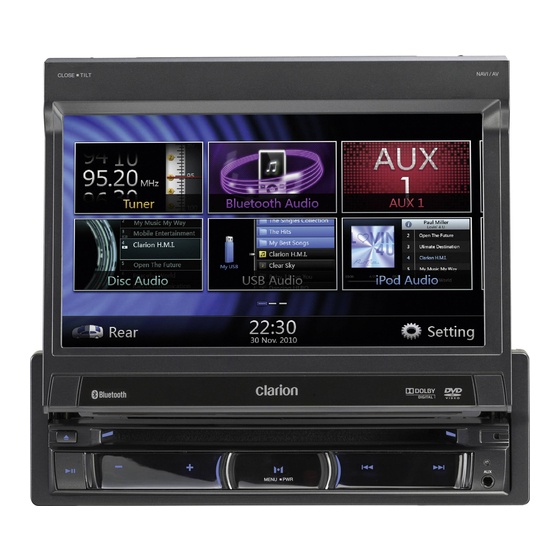
Page 15: Main Menu Operations
1. Press any quadrate icon on mainmenu more than Press screen and scrolling to right or left it will 2 seconds, the icon will float on mainmenu. switch to next or previous page of mainmenu. 2. Scrolling the floating icon to any position you want. NX501E/NZ501E... -
Page 16: Dvd System
About playing a CD-R/CD-RW disc (MP3, WMA) The operation procedures vary with the disc; observe This player can play CD-R/CD-RW discs previously the instructions for selecting a story provided during recorded in music CD format (MP3, WMA). playback. NX501E/NZ501E... -
Page 17: About The Registered Marks, Etc
Bluetooth SIG, Inc. and any use of such ® Laboratories.“Dolby”, “Pro Logic” and the double-D marks by Clarion Co., Ltd. is under license. Other symbol are trademarks of Dolby Laboratories. trademarks and trade names are those of their respective owners. -
Page 18: Dvd Video Player Operations
Only Adult • The contents that the parental level restricts vary with the country code. Note: The rating can be selected only under the password unlocked status, and the limits can be set only under the password locked status. NX501E/NZ501E... -
Page 19: Watching To A Disc
Chapters are skipped down or up from current locations, as many times as the button is pressed, and playback starts. Skip use seek bar Press the triangle [ ] on seek bar and drag it to any position where you want to start playback. NX501E/NZ501E... -
Page 20: Repeat Playback
[0] to [9] key. 4. Touch [ ] button to fix on the selected item. 3. Touch the [ ] button. 5. Touch [ ] button. Playback starts from the scene of the input title number or chapter number. NX501E/NZ501E... - Page 21 • Depending on the disc, switching may be 12 - Audio Button completely impossible or impossible on some 13 - Subtitle Button scenes. • Depending on the disc, scenes recorded in two or more angles may be played back. NX501E/NZ501E...
-
Page 22: Operate The Video Files Player Menu
Video files list operations is almost same as Disc 2. To resume playback, press the [ ] button. Audio player mode. Please refer to DVD Audio Player Playback resumes from start of the folder which Operations. playing track is in. NX501E/NZ501E... -
Page 23: Dvd Audio Player Operations
Stop Playback 9 - Repeat Button 1. Press the [ ] button on remote control more than 10 - Play/Pause Button 1 second. Playback is stopped. 2. To resume playback, press the [ ] button. Playback resumes from start of disc. NX501E/NZ501E... -
Page 24: Listening To Mp3/Wma
In addition, if you use upper case and lower case letters (capital and small letters) mixed for file extensions, normal play may not be possible. NX501E/NZ501E... - Page 25 Also, the recommended value of VBR ranges from 32 kbps to 320 kbps. • After disc selection, the play mode is automatically engaged. NX501E/NZ501E...
- Page 26 Other operations about playing MP3/WMA are almost between Repeat Track Repeat Folder and Repeat Off. same as CD Player mode. 2. Folder Touch the folder title on the display list, the file list will display files and folders in selected folder. NX501E/NZ501E...
-
Page 27: Usb Audio Operations
• The system may become slow if the files or folders 6 - MP3/WMA files in list exceed the limitation above. 7 - Folders in list 8 - Folders browse control 9 - Playback status info 10 - Album Art NX501E/NZ501E... -
Page 28: Playing Mp3/Wma Files In Usb Memory
The repeat set as the factory default is Repeat Folder. folder. Touch the [ ] button once for Repeat Track, again for Repeat Folder. Note: The repeat in all USB files function is not available. NX501E/NZ501E... - Page 29 1. Touch [ ] Button to show [ ] button. 2. Touch [ ] button .The numerical keypad will appear on the screen. 3. Input the track number that you want to play back with [0] to [9] key. NX501E/NZ501E...
-
Page 30: Usb Video Operations
Press the on seek bar and drag it to any position where you want to start playback. Switch to USB Video Menu Press [ ] button playback will be paused, and the screen will switch to USB Video Menu. NX501E/NZ501E... -
Page 31: Usb Video Menu Operations
] button starts playback from the beginning of the next track. • Pressing [ ] button starts playback from the beginning of the current track; when this button is pressed again within about 5 seconds, playback starts from the beginning of previous track. NX501E/NZ501E... -
Page 32: Ipod/Iphone Operations
• For detailed information on the playable iPod/iPhone Press [MENU] button on Operational Panel to return models, see our home page: www.clarion.com to the Main Menu. Notes on using Apple iPod/iPhone Controlling the iPod/iPhone •... - Page 33 Pause” and “Next Track” can be operated. (Refer The “Progress bar” is not available on this screen. to 17) 23. [ ] Menu: Press the Menu button can display the Simple Control Mode. 24. [ ] Repeat The “Repeat” Button can’t operate on this screen. NX501E/NZ501E...
-
Page 34: Selecting The Ipod Video Mode
] button to display iPod Video play mode screen. 25. Return to the Previous Level Folder ] If the list is in root, press the button can close the list. 26. [ ] Closed the List 27. Search with the first alphabet in current list. NX501E/NZ501E... - Page 35 Note: Video playback is not available on all iPod/ iPhone • iPod Video Simple Control Mode Screen devices. Please contact your Clarion dealer for details. An optional connection cable or accessory may be required for this feature. Note: •...
-
Page 36: Bluetooth Audio Player Operations
• This system will not operate or may operate improperly with some Bluetooth audio players. • For detailed information on the playable Bluetooth audio players, see our home page: www.clarion.com If you want to change the Pin Code setting of this unit, perform the following steps. -
Page 37: Selecting The Bluetooth Audio Player
A confirmation screen is displayed. pressed, and playback starts. 2. Touch the [ ] key to confirm delete. Stopping playback 4. Press the [ ] button during playback. Tracks are stopped, press the [ ] button to playback the first Track. NX501E/NZ501E... -
Page 38: Bluetooth Telephone Operations
Bluetooth Telephone mode. 2. Enter your desired 4-digit PIN number, and then The Telephone screen is displayed. touch the [ ] key. • When no Bluetooth Telephone connected, the icon [ ] is displayed at the top of the screen. NX501E/NZ501E... -
Page 39: Register Your Cellular Phone (Pairing)
• You can also add the favorite icon to the connected device. There are 10 favorite icons for selecting. When the pairing operation completes, the registered cellular phone is set as the current telephone, and the display returns to the Telephone screen. NX501E/NZ501E... -
Page 40: Select The Cellular Phone
Telephone Interrupt screen may be closed and the disable these functions from the cellular phone before connection with this system may be disconnected performing the Object Push transfer. when entering the Private mode. • Some cellular phones may transfer Phone Book data automatically. NX501E/NZ501E... - Page 41 2. Touch the desired History item key you wish to dial. 3. Touch the [ ] key to call the specified number. The Telephone Interrupt screen is displayed, and calling starts. • When the call is finished, touch the [ ] key to hang up. NX501E/NZ501E...
-
Page 42: Radio Operations
Frequency up and down to search for next available station. • When flick the frequency up, the station is searched in the direction of higher frequency. • When flick the frequency down, the station is searched in the direction of lower frequency. NX501E/NZ501E... -
Page 43: Rds Operations
12. Preset List Button 13. Tune Down 14. Tune Up 15. TA Setting 16. AF Setting 17. REG Setting 18. LOC/DX Mode Setting 19. PTY Setting 20. Return Button 21. PTY Seek 22. Auto Store 23. Program Type Display NX501E/NZ501E... - Page 44 ] key of the TA item to set the TA Canceling PTY standby mode standby mode. 1. Touch the [ ] key. 2. Touch the [ ] key of the PTY item. “PTY” goes off, and the PTY standby mode is canceled. NX501E/NZ501E...
- Page 45 Children Children’s Programs Social Social Affairs Religion Religion Phone In Phone In Travel Travel Leisure Leisure Jazz Jazz Music Country Country Music Nation M National Music Oldies Oldies Music Folk M Folk Music Document Documentary Test Test Alarm Alarm NX501E/NZ501E...
-
Page 46: Dvb-T Operations
• Press [DVB-T] button on Main Menu to select desired mode (when unit is reading). The LCD will display the external video. If there is no DVB-T signal, it will show you blank screen. • Press [Menu] button on Operational Panel to return to the Main Menu. NX501E/NZ501E... -
Page 47: Aux 1 / Aux 2 Operations
Press Menu button on Operational Panel to return to the Main Menu. Note: If the reverse cable is connected correctly to the car, the center unit to switch to camera mode automatically when the car is in reverses. NX501E/NZ501E... -
Page 48: Rear Source Operations
]: Next Row Buttons Press the button can display the hidden button. 2. [ ]: Previous chapter. 3. [ ]: Play or Pause video. 4. [ ]: Next chapter. 5. Elapsed playing time indicator. 6. [ ] Top Menu Button NX501E/NZ501E... -
Page 49: Aux 1 In Rear
Remote Control is always available for the front source, however, it is available for the rear source if the screen displays Rear Source Control of DVD Video or iPod Video. iPod Video in Rear iPod Video Rear Source Control Play Mode NX501E/NZ501E... -
Page 50: Setting Operations
Beep: Turn on or turn off the beep confirmation sound. Bluetooth: Set the Bluetooth ON or OFF. Wallpaper: Choose the desired wallpaper. This menu includes: Balance, Fader, Select EQ, Sub Woofer Ctrl, Sub Woofer Phase, High Pass Filter, low Pass Filter, Amp Cancel and Magna Bass EX. NX501E/NZ501E... -
Page 51: Navigation Setup Menu
“Popup”: When small turn info window will pop up in the top of the AV screen to indicate the key point. “Off”: Turn off this function. Voice Guidance: Enable or disable the navigation voice guidance. NX501E/NZ501E... -
Page 52: Monitor Off
Long Press Menu button on Operational Panel for 3 seconds, it will show “Monitor off……Touch the screen to return” and then the head unit will turn off the TFT screen. Touch any place of the screen, the TFT screen will turn on again. NX501E/NZ501E... -
Page 53: Troubleshooting
The parking brake is not engaged. displayed. engaged. Release the view limitation or change Disc cannot play with the parental level. the display “PARENTAL Feature exceeds set parental level. See the subsection “Setting up the VIOLATION” shown. parental level”. NX501E/NZ501E... -
Page 54: Usb Device
The audio quality is poor after Move the device closer to the connection with a Bluetooth car audio system or remove any enabled device. The Bluetooth reception is poor. obstacle between the device and the system. NX501E/NZ501E... -
Page 55: Tv/Vtr (When Connecting An Optional Tv Tuner, Etc.)
If an error display other than the ones described above appears, press the Reset button. If the problem persists, turn off the power and consult your store of purchase. * When the Reset button is pressed, frequencies of radio stations, titles, etc. stored in memory are cleared. NX501E/NZ501E... -
Page 56: Specifications
Audio/Video output Current consumption: 4.0 A @1 W Video output voltage: 1.0 V Auto Antenna Rated Current: 500 mA less NX501E Screen Size: 6.2” wide type Pixels: 1,152,000 Resolution: 800 x 480 x 3 (RGB) Note: NZ501E Screen Size: 7” wide type •... - Page 57 178 mm 50 mm 178 mm 100 mm NX501E dimensions: NZ501E dimensions: NX501E weight: 2.4 kg NZ501E weight: 2.4 kg 52 mm 12 mm Remote Control dimensions: Remote Control weight: 50g (including battery) NX501E/NZ501E...
-
Page 58: Installation / Wire Connection Guide
Line out cable (NX501E only) ....1 Cleaning cloth........... 1 Line in cable (NX501E only) ...... 1 Warranty Card .......... 1 Rear Zone out cable (NX501E only) ..1 Owner’s manual and SWI cable (NX501E only) ......1 Installation manual........2 DTV cable (NX501E only)...... -
Page 59: Cautions On Installation
For installation, consult your dealer or an authorized tough dirt, apply a little cold or warm water to a soft Clarion service center. cloth and wipe off the dirt gently. 4. Cautions on Installation 1. -
Page 60: Installing The Main Unit
(1 pair for the left and right sides) (Attached to the main unit) Figure 6 Note: * 1: Position the face panel with its wide edge at the bottom. Fit the edge into the groove of the main unit. NX501E/NZ501E... - Page 61 Vehicles other than NISSAN and TOYOTA In some cases the center panel may require modification. (Trimming, filing, etc.) • Removing the Main Unit When the main unit is to be removed, disassemble it in the reverse of the order in “INSTALLING THE MAIN UNIT”. NX501E/NZ501E...
-
Page 62: Cautions On Wiring
There are various types of fuse holder. Do not let the battery side touch other metal parts. CAUTION After the connection, fix the cord by a clamp or insulation tape for protection. Fuse (15A FUSE) Fuse holder Figure 8 NX501E/NZ501E... -
Page 63: Wire Connections
7. Wire Connections Note: • Before installing, be sure to disconnect the negative cable of the car battery. • In the optional devices, the RCA cables and the Connector cables are separately-sold items. NX501E Antenna Black External EX MIC Microphone... - Page 64 Line Out Rear L Line Out Gray Front R White Line Out Front L Yellow Monitor Video Out Black Yellow Camera Rear Vision Camera White Rear zone out L Green Rear zone out R Gray Steering Wheel Remote Control Terminal NX501E/NZ501E...
- Page 65 For VW and Audi: Change wiring as above +12V accessory Note: *1: Connecting the PHONE INTERRUPT terminal The phone interrupt will mute the audio if the lead receives a negative or ground signal. See next page for how to connect the parking brake cord. NX501E/NZ501E...
- Page 66 • Connecting to SIRIUS Satellite Radio Receiver When SIRIUS Satellite Radio Receiver is to be connected, use the dedicated connector. For detailed information,refer to the instruction manual of the SIRIUS Satellite Radio Receiver. NX501E/NZ501E...
- Page 67 English: Español: Declaration of conformity Declaración de conformidad We Clarion declares that this model NX501E/ Clarion declara que este modelo NX501E/ NZ501E is following the provision of Directive NZ501E cumple con los requisitos esenciales 1999/5/EC with the essential requirements and y otras disposiciones aplicables descritos en la the other relevant regulations.
- Page 68 User Manual Clarion Mobile Map NX501E NZ501E...
- Page 69 NX501E/NZ501E right away. This document is the detailed description of the navigation software. You can easily discover Clarion Mobile Map while you are using it; however, we still recommend that you read this manual to fully understand the screens and features. Easy navigation map updates It is easy to keep the navigation system up to date. Simply download new map data from Clarion’s portal site, store them on a microSD card and insert it into the Clarion NX501E/NZ501E via the front card slot. Unpleasant surprises are now avoided as navigation maps will match the real world. Latest Map Guarantee When you start using the product, you have 30 days to download the latest available map free ...
- Page 70 3.1.1.4 Selecting a city/town centre as the destination............ 3 0 3.1.1.5 Entering an address with a postal code .............. 3 1 3.1.1.6 Tips on entering addresses quickly ................ 3 3 3.1.2 Selecting the destination from the Places of Interest ......... 3 4 3.1.2.1 Quick search for a Place of Interest................. 3 4 3.1.2.2 Searching for a Place of Interest using preset categories ........ 3 5 3.1.2.3 Searching for a Place of Interest by category ............ 3 7 3.1.2.4 Searching for a Place of Interest by name ............... 4 0 3.1.2.5 Searching for a Place of Interest by its phone number .......... 4 2 3.1.2.6 Selecting nearby assistance from 'Where Am I?' ............. 4 3 3.1.3 Selecting a map location as the destination ............ 4 5 3.1.4 Selecting the destination from your Favourites .......... 4 6 NX501E/NZ501E English 3 ...
- Page 71 4.1.7.1 Real-time traffic information (TMC ................. 6 8 4.2 'More' menu .................... 6 9 4.3 Settings menu .................... 7 0 4.3.1 Sound and Warnings .................. 7 2 4.3.2 Customise Quick menu .................. 7 3 4.3.3 Traffic settings .................... 7 3 4.3.4 Route settings ..................... 7 3 4.3.5 Green routing settings .................. 7 5 4.3.6 Map settings ....................... 7 6 4.3.7 Visual guidance settings .................. 7 7 4 NX501E/NZ501E English ...
- Page 72 4.3.8 Display settings .................... 7 8 4.3.9 Regional settings .................... 7 8 4.3.10 Trip monitor settings .................. 7 8 5 Glossary .................... 80 6 End User Licence Agreement .............. 82 7 Copyright note .................. 86 NX501E/NZ501E English 5 ...
-
Page 73: 1 Warnings And Safety Information
Clarion Mobile Map before you start your journey. Plan the route before your departure and stop if you need to change the route. You must obey the traffic signs and follow the road geometry. If you deviate from the recommended route, Clarion Mobile Map changes the instructions accordingly. Never place NX501E/NZ501E where it obstructs the driver's view, where it is in the deployment zone of an airbag or where it might cause injuries in an accident. For more information, consult the End User Licence Agreement (page 82). 6 NX501E/NZ501E English ... -
Page 74: 2 Getting Started
2 Getting started Clarion Mobile Map is optimised for in-car use. You can use it easily by tapping the screen buttons and the map with your fingertips. When using the navigation software for the first time, an initial setup process starts automatically. Do as follows: 1. Select the written language of the application interface. Later you can change it in Regional settings (page 78). to continue. 2. Read the End User Licence Agreement. Tap to continue. ... -
Page 75: Buttons And Other Controls On The Screen
. After the initial setup, the Map screen appears and you can start using Clarion Mobile Map. 2.1 Buttons and other controls on the screen When you are using Clarion Mobile Map, you usually tap buttons on the touch screen. You only need to confirm selections or changes if the application needs to restart, it needs to perform a major reconfiguration, or you are about to lose some of your data or settings. Otherwise, Clarion Mobile Map saves your selections and applies the new settings without confirmation as soon as you use the controls. Type Example Description How to use it Button ... -
Page 76: Using Keyboards
Task Instruction Switching to another keyboard layout, for example from an English keyboard to a button and select the Tap the Greek keyboard new keyboard layout from the list. Correcting your entry on the keyboard to remove the unneeded character(s). Tap Tap and hold the button to delete several characters or the entire input string. Entering a space, for example between a first name and a family name or in multi- button at the bottom centre of the Tap the word street names screen. Entering numbers and symbols to switch to a keyboard offering Tap numeric and symbol characters. NX501E/NZ501E English 9 ... -
Page 77: Beyond Single Screen Tap
Action Details Tapping and holding Tap and keep pressing the following buttons to reach extra functions: the screen on list and menu screens: the Tap and hold Map screen appears. Tap and hold any of the , , , , , and buttons on the Map screen: you can rotate, tilt or scale the map continuously. on keyboard screens: you can delete Tap and hold several characters quickly. or in long lists: you can scroll pages Tap and hold continuously. Gestures (drag&drop) You need to drag and drop the screen only in cases like: Moving the handle on a slider. Scrolling the list: grab the list anywhere and slide your finger up or down. Depending on the speed of the sliding, the list will scroll fast or slow, only a bit or till the end. Moving the map in map browsing mode: grab the map, and move it in the desired direction. 10 NX501E/NZ501E English ... -
Page 78: Map Screen
When there is no GPS position, the Vehimarker is transparent. It shows your last known position. You see coloured dots circling around a satellite symbol in the top left corner. The more green dots you see, the closer you are to get the valid GPS position. When GPS position is available, the Vehimarker is displayed in full colour, now showing your current position. There are screen buttons and data fields on the screen to help you navigate. During navigation, the screen shows route information. By default, only one data field is displayed in the bottom right corner. Tap this field to see all route data fields. NX501E/NZ501E English 11 ... - Page 79 Shows the time needed to reach the final destination of the route based on information available for the remaining segments of the route. If NX501E/NZ501E is capable of receiving live traffic information, the calculation takes into account traffic delays affecting your route if they are received. However, this calculation is rarely accurate. Shows the estimated arrival time at the final destination of the route based ...
-
Page 80: Position Markers
2.2.3 Objects on the map 2.2.3.1 Streets and roads Clarion Mobile Map shows the streets in a way that is similar to how the paper road maps show them. Their width and colours correspond to their importance: you can easily tell a motorway from a small street. 2.2.3.2 Turn preview and Next street When navigating a route, the top section of the Map screen shows information about the next ... - Page 81 A smaller icon shows the type of the second next manoeuvre if it is near the first one. Otherwise, only the next manoeuvre is displayed. Most of these icons are very intuitive. The following table lists some of the frequently shown route events. The same symbols are used in both fields: Icon Description Turn left. Turn right. Turn back. Bear right. Turn sharp left. Keep left. Continue straight in the intersection. Go left on the roundabout, 3rd exit (next manoeuvre). Enter roundabout (second next manoeuvre). Enter motorway. Exit motorway. Board ferry. Leave ferry. Approaching a waypoint. Approaching the destination. 14 NX501E/NZ501E English ...
-
Page 82: Lane Information And Signposts
If you want to hide the currently displayed junction, tap the picture and the Map screen returns. 2.2.3.5 3D object types Clarion Mobile Map supports the following 3D object types: Type Description 3D terrain 3D terrain map data shows changes in terrain, elevations or depressions in the land when you view the map in 2D, and use it to plot the route map in 3D when you navigate. Hills and mountains are shown in the background of the 3D map, and illustrated by colour and shading on the 2D map. Elevated roads Complex intersections and vertically isolated roads (such as overpasses or bridges) are displayed in 3D. Landmarks are 3D artistic or block representations of prominent or well- 3D landmarks known objects. NX501E/NZ501E English 15 ... -
Page 83: Elements Of The Active Route
Current GPS position and Your current position displayed on the map. If Start point roads are near, it is aligned to the nearest road. Normally if GPS position is available, the route starts from the current position. If there is no valid GPS position, Clarion Mobile Map uses the last known position as the start point. Waypoint (intermediate An intermediate destination of the route before destination) reaching the final destination. Destination (end point) ... -
Page 84: Manipulating The Map
Tap the map anywhere to browse it during navigation. The map stops following the current position (the Vehimarker, a red arrow by default, is not locked in a fix position on the screen any more) and control buttons appear to help you modify the map view. Action Button(s) Description Moving the map with No buttons You can move the map in any direction: tap drag&drop and hold the map, and move your finger towards the direction you want to move the map. NX501E/NZ501E English 17 ... - Page 85 Zooming in and out Changes how much of the map is displayed on the screen. , Clarion Mobile Map uses high-quality vector maps that let you examine the map at various zoom levels, always with optimised content. It always displays street names and other text with the same font size, never upside-down, ...
-
Page 86: Quick Menu
There are more functions available than the number of buttons in the menu. In Settings, you can choose the function of each button (page 73). The following options are available: Button Description Shortcut for Find / Find Places / This function lets you search for a Place along your route Quick Search (page or around your current location if there is no route 34) calculated. Find / Favourite (page This button opens the list of your Favourite destinations. 46) Find / History (page This button opens the History list. You can select one of 48) your previous destinations. My Route / Edit Route This button opens the route editing function. More / Settings / This button opens the route related settings. Route Settings (page 73) More / Settings / Map This button opens the map related settings. Settings (page 76) NX501E/NZ501E English 19 ... - Page 87 More / Trip Monitor This button opens the Trip Monitor screen where you can (page 69) manage your previously saved trip logs and track logs. Tap the top of the Map This button opens the list of manoeuvres (the itinerary). screen during navigation. My Route / More / With this function you can save the active route for later Save Route use. My Route / More / With this function you can replace the active route with a Load Route previously saved route. Find / Find Places With this function you can search for Places of Interest in (page 34) various different ways. My Route / More / This button opens the Map screen and starts simulating Simulate Navigation the active route. (page 62) 20 NX501E/NZ501E English ...
-
Page 88: Checking The Details Of The Current Position (Where Am
Tap the top of the Map This button opens the GPS Information screen with screen when there is satellite position and signal strength information. no GPS reception This button offers your Home location as a destination. 2.2.6 Checking the details of the current position (Where Am I?) This screen contains information about the current position (or about the last known position if GPS reception is not available) and a button to search for useful Places nearby. . You can access this screen from the map in one of the following ways: If the current street is displayed below the Vehimarker (the current position on the map), tap it to open the Where Am I? screen. button. Open the Quick menu and tap the Information on this screen: , : Latitude and Longitude (coordinate of the current position in WGS84 format). : Altitude (elevation information coming from the GPS receiver - often inaccurate). : House number on the left. : House number on the right. In the middle of the screen you can see whether the position is current, or the time left since it was last updated. Address details (when available) of the current position are also displayed at the bottom. You can also perform some actions on this screen: NX501E/NZ501E English 21 ... -
Page 89: Navigation Menu
to save the current position as a Favourite destination. Tap to You can also search for assistance near your current position. Tap open a new screen for the Quick search: The following services can be searched around the current position or the last known position: : Car repair and roadside assistance services : Medical and emergency services : Police stations : Petrol stations Tap any of the buttons, select a Place from the list, and navigate to it. 2.3 Navigation menu You can reach all parts of Clarion Mobile Map from the Navigation menu. You have the following options: to select your destination by entering an address or selecting Tap a place of interest, a location on the map or one of your Favourite destinations. You can also look up your recent destinations from the Smart History or enter a coordinate. to display the route parameters and the route in its full length Tap on the map. You can also perform route-related actions such as editing or cancelling your route, setting a start point for the route, picking route alternatives, avoiding parts of the route, simulating navigation or adding the destination to your Favourites. 22 NX501E/NZ501E English ... - Page 90 to customise the way the navigation software works, watch Tap the Tutorial, simulate demo routes, or to run some additional applications. to start navigating on the map. The button itself is a miniature Tap live map that shows your current position, the recommended route and the surrounding map area. Tap the button to enlarge the map to the full screen. to open the Traffic Summary screen. Tap NX501E/NZ501E English 23 ...
-
Page 91: 3 Navigating
You can add as many destinations to your route as you like. 3.1 Selecting the destination of a route Clarion Mobile Map offers you several ways of choosing your destination: Enter a full address or a part of an address, for example a street name without a house number or the names of two intersecting streets (page 24). Enter an address with postal code (page 31). This way you do not need to select the name of the city/town and the search for street names might be faster as well. Use a built-in Place of Interest as your destination (page 34). Select a location on the map with the Find on Map feature (page 45). Use a previously saved Favourite destination (page 46). Select a location from the History of previously used destinations (page 48). Enter the coordinate of the destination (page 48). Use the location where a photo was taken (page 50). 3.1.1 Entering an address or a part of the address If you know at least a part of the address, it is the quickest way to select the destination of the route. Using the same screen, you can find an address by entering: the exact address, including house number the centre of a city/town an intersection the midpoint of a street any of the above, starting the search with the postal code (page 31) 3.1.1.1 Entering an address To enter an address as the destination, do as follows: 24 NX501E/NZ501E English ... - Page 92 to return to the Navigation 1. If you are on the Map screen, tap menu. 2. In the Navigation menu, tap the following buttons: , . 3. By default, Clarion Mobile Map proposes the country and city/town where you are. If needed, tap , enter the first few letters of the country name on the keyboard, and select one country from the list of results. 4. If needed, select a new city/town: a. Tap . b. Start entering the name of the city/town on the keyboard. c. Find the city/town you need: The most likely city/town name is always shown in the input field. To accept it, tap . If the desired name does not show up, the names that match the string ...
- Page 93 to finish entering the address. (If the entered house c. Tap number cannot be found, the midpoint of the street is selected as the destination.) 7. A full screen map appears with the selected point in the middle. If necessary, tap the map somewhere else to modify the destination. The Cursor ( ) appears at the to confirm the destination, or tap new location. Tap to select a different destination. 8. After a short summary of the route parameters, the map appears showing the entire to modify route route. The route is automatically calculated. Tap and start your journey. parameters, or tap 26 NX501E/NZ501E English ...
-
Page 94: Entering The Midpoint Of A Street As The Destination
The most likely street name is always shown in the input field. To accept it, tap . If the desired name does not show up, the names that match the string appear in a list after entering a couple of characters (to open the list of results before it appears automatically, tap ). Select the street from the list. NX501E/NZ501E English 27 ... -
Page 95: Selecting An Intersection As The Destination
5. Instead of entering the house number, tap . The midpoint of the street is selected as the destination. 6. A full screen map appears with the selected point in the middle. If necessary, tap the map somewhere else to modify the destination. The Cursor ( ) appears at the to confirm the destination, or tap new location. Tap to select a different destination. 7. After a short summary of the route parameters, the map appears showing the entire to modify route route. The route is automatically calculated. Tap and start your journey. parameters, or tap 3.1.1.3 Selecting an intersection as the destination To enter an address as the destination, do as follows: to return to the Navigation 1. If you are on the Map screen, tap menu. 2. In the Navigation menu, tap the following buttons: , . 3. If necessary, modify the country and city/town as described earlier (page 24). 28 NX501E/NZ501E English ... - Page 96 5. Enter the intersecting street name: 1. Tap . If only a few intersecting streets exist, their list appears immediately. In case of a longer street, the keyboard screen appears. Start entering the name of the intersecting street on the keyboard. As soon as the street names that match the entered string can be shown on one screen, their list appears automatically. Select from the list. 6. A full screen map appears with the selected point in the middle. If necessary, tap the map somewhere else to modify the destination. The Cursor ( ) appears at the to confirm the destination, or tap new location. Tap to select a different destination. 7. After a short summary of the route parameters, the map appears showing the entire to modify route route. The route is automatically calculated. Tap and start your journey. parameters, or tap NX501E/NZ501E English 29 ...
-
Page 97: Selecting A City/Town Centre As The Destination
If the desired name does not show up, the names that match the string appear in a list after entering a couple of characters (to open the list of results before it appears automatically, tap ). Select the city/town from the list. 5. Instead of entering the street name, tap . This way the centre of the displayed city/town becomes the destination of the route. 30 NX501E/NZ501E English ... -
Page 98: Entering An Address With A Postal Code
and start your journey. parameters, or tap 3.1.1.5 Entering an address with a postal code All of the above address searching possibilities can be performed with entering the postal code instead of the city/town name. Find below an example with a full address: to return to the Navigation 1. If you are on the Map screen, tap menu. 2. In the Navigation menu, tap the following buttons: , . 3. If necessary, modify the country as described earlier (page 24). 4. Enter a new city/town using its postal code: a. Tap . to open the numeric keypad. b. Tap c. Start entering the postal code. NX501E/NZ501E English 31 ... - Page 99 ). Select the street from the list. 6. Enter the house number: a. Tap . b. Enter the house number on the keyboard. (To enter letters, tap ). to finish entering the address. (If the entered house c. Tap number cannot be found, the midpoint of the street is selected as the destination.) 32 NX501E/NZ501E English ...
-
Page 100: Tips On Entering Addresses Quickly
7. A full screen map appears with the selected point in the middle. If necessary, tap the map somewhere else to modify the destination. The Cursor ( ) appears at the to confirm the destination, or tap new location. Tap to select a different destination. 8. After a short summary of the route parameters, the map appears showing the entire to modify route route. The route is automatically calculated. Tap and start your journey. parameters, or tap 3.1.1.6 Tips on entering addresses quickly When you are entering the name of a city/town or a street: Only those letters are offered on the keyboard that appear in possible search results. All other characters are greyed out. As you are typing, the most likely result is always displayed in the input field. If to select it. the guess is correct, tap After entering a couple of letters, tap to list the items that contain the specified letters. You can speed up finding an intersection: Search first for the street with a less common or less usual name; fewer letters are enough to find it. If one of the streets is shorter, search for that one first. You can then find the second one faster. You can search for both the type and the name of a road. If the same word appears in several names, for example in the name of streets, roads and avenues, you can obtain the result faster if you enter the first letter of the street type: For example, enter 'PI A' to obtain Pine Avenue and skip all Pine Streets and Pickwick Roads. NX501E/NZ501E English 33 ... -
Page 101: Selecting The Destination From The Places Of Interest
The Quick search feature lets you quickly find a Place by its name. The search is always carried out along the recommended route if it exists or around your current location if there is no destination given. 1. Start the Quick search function: and then tap If you are on the Map screen, tap . and then If you are in the Navigation menu, tap , tap . 2. Using the keyboard, start entering the name of the Place. to open the list of Places with 3. After entering a few letters, tap names containing the entered character sequence. 34 NX501E/NZ501E English ... -
Page 102: Searching For A Place Of Interest Using Preset Categories
4. (optional) The Places in the list are ordered by the length of the necessary detour (when navigating a route) or by their distance from the current position (when no destination is given). If you need to reorder the list, tap . 5. Browse the list if necessary and tap one of the list items. A full screen map appears with the selected point in the middle. The name and address of the Place is displayed at the top of the screen. to see the details of the selected Place. Tap 6. (optional) Tap to return to the map. 7. If necessary, tap the map somewhere else to modify the destination. The Cursor to confirm the ) appears at the new location. Tap to select a different destination. destination, or tap 8. After a short summary of the route parameters, the map appears showing the entire to modify route route. The route is automatically calculated. Tap and start your journey. parameters, or tap 3.1.2.2 Searching for a Place of Interest using preset categories The Preset search feature lets you quickly find the most frequently selected types of Places. to return to the Navigation 1. If you are on the Map screen, tap menu. 2. In the Navigation menu, tap the following buttons: , . NX501E/NZ501E English 35 ... - Page 103 If the current position is not available either (no GPS signal), they are searched around the last known position. : If an active route exists, accommodation is searched around the destination of the route. If there is no active route (destination is not selected), they are searched around the current position. If the current position is not available either (no GPS signal), they are searched around the last known position. 4. Tap any of the quick search buttons to get an instant list of Places. 36 NX501E/NZ501E English ...
-
Page 104: Searching For A Place Of Interest By Category
6. Browse the list if necessary and tap one of the list items. A full screen map appears with the selected point in the middle. The name and address of the Place is displayed at the top of the screen. to see the details of the selected Place. Tap 7. (optional) Tap to return to the map. 8. If necessary, tap the map somewhere else to modify the destination. The Cursor to confirm the ) appears at the new location. Tap to select a different destination. destination, or tap 9. After a short summary of the route parameters, the map appears showing the entire to modify route route. The route is automatically calculated. Tap and start your journey. parameters, or tap 3.1.2.3 Searching for a Place of Interest by category You can search for Places of Interest by their categories and subcategories. to return to the Navigation 1. If you are on the Map screen, tap menu. 2. In the Navigation menu, tap the following buttons: , . 3. Tap . 4. Select the area around which the Place should be searched for: to search around the current position or if it is not Tap available, around the last know position. (The result list will be ordered by the distance from this position.) NX501E/NZ501E English 37 ... - Page 105 to search for a place within a selected city/town. (The Tap result list will be ordered by the distance from the centre of the selected city/town.) to search for a place around the destination of the Tap active route. (The result list will be ordered by the distance from the destination.) to search along the active route, and not around a Tap given point. This is useful when you search for a later stopover that results in a minimal detour only, such as searching for upcoming petrol stations or restaurants. (The result list will be ordered by the length of the necessary detour.) 5. (optional) If you have selected , select the city/town to search in. 6. Select one of the main Place categories (e.g. Accommodation) or tap to list all Places around the selected location or along the route. 7. Select one of the Place subcategories (e.g. Hotel or Motel) or tap to list all Places in the selected main category around the selected location or along the route. 38 NX501E/NZ501E English ...
- Page 106 8. Sometimes the list of brands in the selected Place subcategory appears. Select one to list all Places in the selected subcategory around brand or tap the selected location or along the route. 9. Finally, the results appear in a list. 10. (optional) The Places in the list are ordered by their distance from the current or last known position, from the selected city/town, from the destination or by the length of the necessary detour. If you need to reorder the list, tap . 11. Browse the list if necessary and tap one of the list items. A full screen map appears with the selected point in the middle. The name and address of the Place is displayed at the top of the screen. to see the details of the selected Place. Tap 12. (optional) Tap to return to the map. 13. If necessary, tap the map somewhere else to modify the destination. The Cursor to confirm the ) appears at the new location. Tap to select a different destination. destination, or tap 14. After a short summary of the route parameters, the map appears showing the entire to modify route route. The route is automatically calculated. Tap and start your journey. parameters, or tap NX501E/NZ501E English 39 ...
-
Page 107: Searching For A Place Of Interest By Name
Place database or in one Place category or subcategory only. to return to the Navigation 1. If you are on the Map screen, tap menu. 2. In the Navigation menu, tap the following buttons: , . 3. Tap . 4. Select the area around which the Place should be searched for: to search around the current position or if it is not Tap available, around the last know position. (The result list will be ordered by the distance from this position.) to search for a place within a selected city/town. (The Tap result list will be ordered by the distance from the centre of the selected city/town.) to search for a place around the destination of the Tap active route. (The result list will be ordered by the distance from the destination.) to search along the active route, and not around a Tap given point. This is useful when you search for a later stopover that results in a minimal detour only, such as searching for upcoming petrol stations or restaurants. (The result list will be ordered by the length of the necessary detour.) 40 NX501E/NZ501E English ... - Page 108 , select the city/town to search in. 5. (optional) If you have selected 6. Select one of the main Place categories (e.g. Accommodation) to search in or tap to search among all Places. 7. Select one of the Place subcategories (e.g. Hotel or Motel) to search in or tap to search in the selected Place category. if you have not done it before. 8. Tap 9. Using the keyboard, start entering the name of the Place. NX501E/NZ501E English 41 ...
-
Page 109: Searching For A Place Of Interest By Its Phone Number
to open the list of Places with 10. After entering a few letters, tap names containing the entered character sequence. 11. (optional) The Places in the list are ordered by their distance from the current or last known position, from the selected city/town, from the destination or by the length of the necessary detour. If you need to reorder the list, tap . 12. Browse the list if necessary and tap one of the list items. A full screen map appears with the selected point in the middle. The name and address of the Place is displayed at the top of the screen. to see the details of the selected Place. Tap 13. (optional) Tap to return to the map. 14. If necessary, tap the map somewhere else to modify the destination. The Cursor to confirm the ) appears at the new location. Tap to select a different destination. destination, or tap 15. After a short summary of the route parameters, the map appears showing the entire to modify route route. The route is automatically calculated. Tap and start your journey. parameters, or tap 3.1.2.5 Searching for a Place of Interest by its phone number You can search for Places of Interest by their phone number: to return to the Navigation 1. If you are on the Map screen, tap menu. 2. In the Navigation menu, tap the following buttons: , . 42 NX501E/NZ501E English ... -
Page 110: Selecting Nearby Assistance From 'Where Am
3. The numeric keyboard appears. Enter the phone number you are looking for or a part of it. . 4. Tap 5. The list of Places with the entered sequence in their phone number appears. 6. (optional) The Places in the list are ordered by their distance from the current or last known position, from the selected city/town, from the destination or by the length of the necessary detour. If you need to reorder the list, tap . 7. Browse the list if necessary and tap one of the list items. A full screen map appears with the selected point in the middle. The name and address of the Place is displayed at the top of the screen. to see the details of the selected Place. Tap 8. (optional) Tap to return to the map. 9. If necessary, tap the map somewhere else to modify the destination. The Cursor to confirm the ) appears at the new location. Tap to select a different destination. destination, or tap 10. After a short summary of the route parameters, the map appears showing the entire to modify route route. The route is automatically calculated. Tap and start your journey. parameters, or tap 3.1.2.6 Selecting nearby assistance from 'Where Am I?' You can quickly search for nearby assistance from the 'Where Am I?' screen. to open the Quick menu. 1. On the Map screen, tap NX501E/NZ501E English 43 ... - Page 111 2. Tap , and then . 3. Preset search categories appear, all for searching around the current position (or around the last known position if the current position is not available): : Car repair and roadside assistance services : Medical and emergency services : Police stations : Petrol stations 4. Tap any of the quick search buttons to get an instant list of that type of Places. 5. (optional) The Places in the list are ordered by their distance from the current or last known position, from the selected city/town, from the destination or by the length of the necessary detour. If you need to reorder the list, tap . 6. Browse the list if necessary and tap one of the list items. A full screen map appears with the selected point in the middle. The name and address of the Place is displayed at the top of the screen. to see the details of the selected Place. Tap 7. (optional) Tap to return to the map. 44 NX501E/NZ501E English ...
-
Page 112: Selecting A Map Location As The Destination
8. If necessary, tap the map somewhere else to modify the destination. The Cursor to confirm the ) appears at the new location. Tap to select a different destination. destination, or tap 9. After a short summary of the route parameters, the map appears showing the entire to modify route route. The route is automatically calculated. Tap and start your journey. parameters, or tap 3.1.3 Selecting a map location as the destination to return to the Navigation 1. If you are on the Map screen, tap menu. 2. In the Navigation menu, tap the following buttons: , . 3. Locate your destination on the map: move and scale the map as needed. 4. Tap the location that you want to select as your destination. The Cursor ( ) appears. to select the Cursor as the destination. 5. Tap 6. After a short summary of the route parameters, the map appears showing the entire to modify route route. The route is automatically calculated. Tap and start your journey. parameters, or tap NX501E/NZ501E English 45 ... -
Page 113: Selecting The Destination From Your Favourites
3.1.4 Selecting the destination from your Favourites You can select a location that you have already saved as a Favourite to be your destination. Adding a location to the list of Favourite destinations is described on page 60. 1. Access the list of Favourites: and then tap If you are on the Map screen, tap . and then tap If you are in the Navigation menu, tap . 2. The list of Favourite destinations is displayed. 3. Tap the Favourite that you want to set as your destination. If necessary, browse down and enter a few letters from the to see more of the list or tap name of the Favourite destination. 4. A full screen map appears with the selected point in the middle. If necessary, tap the map somewhere else to modify the destination. The Cursor ( ) appears at the to confirm the destination, or tap new location. Tap to select a different destination. 5. After a short summary of the route parameters, the map appears showing the entire to modify route route. The route is automatically calculated. Tap and start your journey. parameters, or tap 46 NX501E/NZ501E English ... -
Page 114: Selecting Your Home Location
To navigate to your Home location, first you need to save it. Seach for your address or and browse the map and when the Cursor is at the desired location, tap select . Now that the Home location is set, you can quickly navigate to it: 1. To select the Home location, do one of the following: and then tap (this button can If you are on the Map screen, tap be added to the Quick menu in Settins - page 73). and then tap If you are in the Navigation menu, tap . 2. A full screen map appears with the selected point in the middle. If necessary, tap the map somewhere else to modify the destination. The Cursor ( ) appears at the to confirm the destination, or tap new location. Tap to select a different destination. 3. After a short summary of the route parameters, the map appears showing the entire to modify route route. The route is automatically calculated. Tap and start your journey. parameters, or tap NX501E/NZ501E English 47 ... -
Page 115: Selecting A Recent Destination From The History
3.1.6 Selecting a recent destination from the History The destinations that you have set earlier appear in the History. 1. Access the History: and then tap If you are on the Map screen, tap . and then tap If you are in the Navigation menu, tap . 2. The list of recent destinations appears. Smart History promotes three destinations to the first page based on your previous routes (most likely destinations). The rest of the destinations are ordered by time they were last selected. If necessary, scroll the list to see earlier destinations. 3. Select a destination from the list. 4. A full screen map appears with the selected point in the middle. If necessary, tap the map somewhere else to modify the destination. The Cursor ( ) appears at the to confirm the destination, or tap new location. Tap to select a different destination. 5. After a short summary of the route parameters, the map appears showing the entire to modify route route. The route is automatically calculated. Tap and start your journey. parameters, or tap 3.1.7 Entering the coordinate of the destination You can also select a destination by entering its coordinate. Do as follows: 48 NX501E/NZ501E English ... - Page 116 to return to the Navigation 1. If you are on the Map screen, tap menu. 2. In the Navigation menu, tap . 3. Tap . 4. You can enter the latitude and longitude values in any of the following formats: decimal degrees; degrees and decimal minutes; or degrees, minutes and decimal seconds. then and enter 5. (optional) If necessary, tap the coordinate in UTM format. 6. When finished, tap . 7. A full screen map appears with the selected point in the middle. If necessary, tap the map somewhere else to modify the destination. The Cursor ( ) appears at the to confirm the destination, or tap new location. Tap to select a different destination. 8. After a short summary of the route parameters, the map appears showing the entire to modify route route. The route is automatically calculated. Tap and start your journey. parameters, or tap NX501E/NZ501E English 49 ...
-
Page 117: Navigate To A Location Stored In A Photo
3.1.8 Navigate to a location stored in a photo You can also set the location stored in a photo as your destination. Do as follows: to return to the Navigation 1. If you are on the Map screen, tap menu. 2. In the Navigation menu, tap . menu and tap 3. Open the . 4. The list of photos stored in the device appears. Select one photo from the list. 5. A full screen map appears with the selected point in the middle. If necessary, tap the map somewhere else to modify the destination. The Cursor ( ) appears at the to confirm the destination, or tap new location. Tap to select a different destination. 6. After a short summary of the route parameters, the map appears showing the entire to modify route route. The route is automatically calculated. Tap and start your journey. parameters, or tap Note! Only geotagged JPG files contain location information. That is why these kind of files can only be used in navigation. Other picture files do not appear in the list. Files must be located on an inserted SD card or USB pendrive, either in the root folder or in a "pictures" folder. 50 NX501E/NZ501E English ... -
Page 118: Building A Route From The List Of Destinations (Create Route)
3.1.9 Building a route from the list of destinations (Create Route) You can also build your route destination by destination from the My Route menu. to return to the Navigation 1. If you are on the Map screen, tap menu. 2. In the Navigation menu, tap . 3. Tap . 4. There is only one line in the list of route points, the start point of the route, normally the current GPS position. to select the destination. 5. Tap 6. The Destination menu appears and you can select the destination of the route the same way as described in the previous sections. 7. When the new destination is selected, the list returns. where you want to insert the new route point in 8. To add more destinations, tap the list, and repeat the above procedure. 3.2 Viewing the entire route on the map It is easy to get a map overview of the active route. Do as follows: NX501E/NZ501E English 51 ... -
Page 119: Checking Route Parameters And Accessing Route Related Functions
. 3. Tap . The active route is displayed in its full length on the map together with additional information and controls. 3.3 Checking route parameters and accessing route related functions You can check different parameters of the route recommended by Clarion Mobile Map. to return to the Navigation 1. If you are on the Map screen, tap menu. 2. In the Navigation menu, tap . 3. The following pieces of information are displayed: The name and/or address of the destination. Warning icons (if any). They provide extra information about your route (e.g. unpaved roads or toll roads to be taken). The total time of the route. The total length of the route. Estimated delay calculated from traffic events on your route. The symbol of the vehicle type used in route calculation. The route planning method (e.g. Fast). 4. You have the following options on this screen (for detailed instructions on how to use them, see the next chapter): to edit the route: to add or remove destinations or Tap change their sequence. You can also set a route start point other than your current location. This can be useful to plan and save a future trip. 52 NX501E/NZ501E English ... -
Page 120: Modifying The Route
(intermediate destination) to the route or append the newly selected destination at the end of the current route. to plan a new route to the newly selected location. The previous Tap destination and waypoint(s) are deleted. to add the newly selected location as an intermediate destination to your Tap route. The other destinations of the route remain intact. Note: the new waypoint is placed among destinations to keep the route optimal. To decide where a waypoint to appear, use the Edit Route feature. NX501E/NZ501E English 53 ... -
Page 121: Setting A New Starting Position For The Route
For normal navigation, all routes are planned from the current position. In order to check future routes, simulate them or see their length in time and distance, you can turn off the GPS receiver. Then you can set the starting point of the route to a different location than the current GPS position. to return to the Navigation 1. If you are on the Map screen, tap menu. 2. In the Navigation menu, tap . 3. If you already have a route, tap . If you are starting a new route, tap . and 4. The first line is the start of the route, normally the current GPS position. Tap confirm your action at the warning message. 5. The Destination menu appears and you can select the start point of the route the same way you select a destination. 54 NX501E/NZ501E English ... -
Page 122: Editing The List Of Destinations (Edit Route)
8. To return to normal navigation, tap . 3.4.3 Editing the list of destinations (Edit Route) You can edit the route by modifying the list of destinations. You can add or remove destinations, modify the start position or reorder the list. to return to the Navigation 1. If you are on the Map screen, tap menu. 2. In the Navigation menu, tap . 3. Tap . 4. You have the following options: to add a new destination. Tap to delete a destination. Tap NX501E/NZ501E English 55 ... -
Page 123: Pausing The Active Route
to modify the start point of the route. Tap to reorder the list. You can do it manually or you can Tap let the application optimise the route for you. 3.4.4 Pausing the active route You do not need to pause the active route: when you start driving again, Clarion Mobile Map restarts the voice instructions from your position. 3.4.5 Cancelling the active route To cancel the navigated route, do one of the following: and then tap If you are on the Map screen, tap . (If you have a route until all waypoints are deleted.) with waypoints, you need to tap and then tap In the Navigation menu, tap .. The active route is deleted with all its waypoints. 3.4.6 Checking route alternatives when planning the route You can select from different route alternatives or change the route planning method after you have selected a new destination. Do as follows: 1. Select a destination as explained earlier, and get to the route confirmation screen. 2. Tap . 56 NX501E/NZ501E English ... -
Page 124: Checking Route Alternatives For An Existing Route
To recalculate the active route with a different route planning method, you can modify the Route settings (page 73). There is another way to do this and to compare different route alternatives with the same route planning method. Do as follows: to return to the Navigation 1. If you are on the Map screen, tap menu. 2. In the Navigation menu, tap . NX501E/NZ501E English 57 ... -
Page 125: Changing The Vehicle Used In Route Planning
3. Tap . 4. Tap . 5. You see the basic details of three route alternatives with the selected route planning method. Tap any of them to see it on the map. and scroll down for 6. Or if you cannot find a good alternative, tap routes with different routing methods. for a few 7. Select one of the route alternatives then tap and hold seconds to return to the Map screen. Clarion Mobile Map recalculates the route. The orange line now shows the new recommended route. 3.4.8 Changing the vehicle used in route planning To recalculate the active route for a different vehicle, do as follows. These changes can also be made in Settings (page 73). 58 NX501E/NZ501E English ... -
Page 126: Changing The Road Types Used In Route Planning
and then tap 1. On the Map screen, tap . and then tap one of the following: 2. Tap 3. Clarion Mobile Map recalculates the route optimised for the new vehicle type. The orange line now shows the new recommended route. 3.4.9 Changing the road types used in route planning To recalculate the active route with different road type preferences, do as follows. These changes can also be made in Settings (page 73). and then tap 1. On the Map screen, tap . 2. Tap any of the listed road types to modify the route. If needed, scroll the list for all road types. You have the following options (their order depends on the selected vehicle type): - You might need to avoid motorways when you are driving a slow car or you are towing another vehicle. NX501E/NZ501E English 59 ... -
Page 127: Saving A Location As A Favourite Destination
- Clarion Mobile Map excludes unpaved roads by default: unpaved roads can be in a bad condition and usually you cannot reach the speed limit on them. to confirm the changes. Clarion Mobile Map recalculates the 3. Tap route. The orange line now shows the new recommended route. 3.5 Saving a location as a Favourite destination You can add any location to Favourites, the list of frequently used destinations. Planning a route to one of the Favourite destinations is described on page 46. 1. Select a destination as described before. It can be an address, a Place, any location on the map, a previously used destination from History, a coordinate or a location where a photo was taken. 2. When the full screen map appears with the selected location in the middle, tap . 3. Tap . 4. (optional) Using the keyboard, you can change the name offered for the Favourite. Tap to enter numbers or symbols. 60 NX501E/NZ501E English ... -
Page 128: Saving A Location As An Alert Point
You can save any map location as an alert point (for example a speed camera or a railway crossing). 1. Browse the map and select a location. The red Cursor appears there. 2. Tap . 3. Scroll down the list and tap . 4. On the newly opened screen, select the type of the alert point, the direction from which you expect the alert, and (if applicable) the speed limit for this alert point. to save the location as a new alert point. 5. Tap 3.7 Editing an alert point You can edit a previously saved or uploaded alert point (for example a speed camera or a railway crossing). NX501E/NZ501E English 61 ... -
Page 129: Watching The Simulation Of The Route
1. Browse the map and select the alert point to edit. The red circle appears around the alert point. . 2. Tap 3. Scroll down the list and tap . 4. On the newly opened screen, modify the type of the alert point, the direction from which you expect the alert, or (if applicable) the speed limit for this alert point. to save the changes to the alert point. 5. Tap 3.8 Watching the simulation of the route You can run a simulated navigation that demonstrates the active route. Do as follows: to return to the Navigation 1. If you are on the Map screen, tap menu. 2. In the Navigation menu, tap . 3. Tap . 62 NX501E/NZ501E English ... - Page 130 4. Scroll down the list and tap . The simulation starts from the starting point of the route, and using a realistic speed, it leads you through the whole recommended route. 1. (optional) You have the following controls during the simulation (the control buttons disappear after a few seconds but you can open them again if you tap the map): : Jump to the next route event (manoeuvre). : Pause the simulation. : Jump to the previous route event (manoeuvre). : Tap to increase the speed of the simulation to 4, 8 or 16 times faster. Now tap again to return to the normal speed. to stop the simulation. 2. Tap NX501E/NZ501E English 63 ...
-
Page 131: 4 Reference Guide
Clarion Mobile Map uses different colour themes during the day and during the night for both the map and the menu screens. Daytime colours are similar to paper road maps, and the menus are bright. The night colour themes use dark colours for large objects to keep the average brightness of the screen low. Clarion Mobile Map offers different daytime and night colour profiles. It can also switch automatically between the daytime and the night schemes based on the current time and GPS position a few minutes before sunrise, when the sky has already turned bright, and a few minutes after sunset, before it becomes dark. 4.1.3 Route calculation and recalculation Clarion Mobile Map calculates the route based on your preferences: ... - Page 132 Manoeuvre restrictions and directional constraints are taken into account when planning a route. Roads are used only if access for cars is allowed. Private roads and resident-only roads are used only if they are inevitable to reach the destination. Walkways are excluded from routes. : All manoeuvres are available in intersections. Directional constraints are taken into account the way that opposite direction is allowed with a low speed. A private road is used only if the destination is there. Walkways are excluded from routes. : Manoeuvre restrictions and directional constraints are taken into account when planning a route. Roads are used only if access for buses is allowed. Private roads, resident-only roads and walkways are excluded from routes. : Manoeuvre restrictions and directional constraints are taken into account when planning a route. Roads are used only if access for taxis is allowed. Private roads, resident-only roads and walkways are excluded from routes. Road types used or avoided in route calculation: NX501E/NZ501E English 65 ...
-
Page 133: Green Routing
Real-time Traffic events are also taken into account and sometimes greatly modify the route. Clarion Mobile Map automatically recalculates the route if you deviate from the proposed itinerary or if a newly received Traffic event concerns a part of the recommended route. For further information about Route settings, see page 73. 4.1.4 Green routing Route calculation is not only about finding the quickest or shortest route. For some of the emission when planning a vehicle types, you can also check the fuel consumption and CO route, and you can create cost effective routes with less effect on the environment. ... -
Page 134: Road Safety Cameras And Other Proximity Alert Points
Note! The warning for road safety cameras is disabled when the GPS position is not yet available or if you are in certain countries where road safety camera warning is prohibited. 4.1.6 Speed limit warning Maps may contain information about the speed limits of the road segments. Clarion Mobile Map is able to warn you if you exceed the current limit. This information may not be available for your region (ask your local dealer), or may not be fully correct for all roads in the map. Speed warning can be fine-tuned in Sound and Warning settings (page 72). ... -
Page 135: Traffic Information In Route Planning
To fine-tune this recalculation, you can set the minimum delay that can trigger a route recalculation, or you can instruct Clarion Mobile Map to have you confirm the new recommended route before it takes effect. You can do these in Traffic settings (page 73). A special icon ( ) is displayed on the Map screen to show you whether traffic events are ... -
Page 136: More' Menu
to open the list of traffic events: Tap Now tap any of the list items to see its details, and to display the affected road segment in its full length on the map: Note! If there are traffic events on the recommended route that the application has not icon will open the list of significant traffic events to let you bypassed, the quickly check them. 4.2 'More' menu The 'More' menu provides you with various options and additional applications. Tap the following buttons: , . NX501E/NZ501E English 69 ... -
Page 137: Settings Menu
Button Description You can configure the program settings, and modify the behaviour of Clarion Mobile Map. Fine-tune route planning options, change the look of the Map screen, turn on or off warnings, or restart the Configuration wizard, etc. See the next chapter for details. Visit clarion.naviextras.com to get additional content, such as new maps or 3D landmarks and useful applications. The scientific calculator helps you in all your calculation needs. Tap the Mode button for additional functions and use the memory to save your results. The Fuel consumption monitor helps you keep track of the consumption of your car even if you do not use navigation for all your journeys. Set the initial odometer value and then record the distance taken and fuel filled in whenever you fill your car. You can also set reminders for regular car maintenance. ... - Page 138 Place visibility sets (which Places to show on the map). Settings related to guidance on the map screen can be adjusted here. Display related settings. These settings allow you to customise the application for your local language, measurement units, time and date settings and formats, as well as to choose the time zone. Trip logs and track logs contain useful information about your trips. Trip logs can be saved manually when you reach your destination or you can turn on the automatic saving here. Modify the basic software parameters set during the initial setup process. For details, see page 7. Delete all saved data and reset all settings to their factory defaults. NX501E/NZ501E English 71 ...
-
Page 139: Sound And Warnings
Tap any of these to hear a sample voice prompt. Just when you have selected the new spoken tap language. Maps may contain information about the speed limits of the road segments. Clarion Mobile Map is able to warn you if you exceed the current limit. This information may not be available for your region (ask your local dealer), or may not be fully correct for all roads in the map. This setting lets you decide whether you wish to receive visible and/or audible warnings. ... -
Page 140: Customise Quick Menu
When calculating a new route, or when recalculation becomes necessary based on the received Traffic events, Clarion Mobile Map avoids traffic events if it makes sense. You can also set the minimum delay that triggers route recalculation, ... - Page 141 They can be enabled or disabled separately from toll roads. Clarion Mobile Map includes toll roads (pay roads where there is a per- use charge) in the routes by default. If you disable toll roads, Clarion Mobile Map plans the best toll-free route. Clarion Mobile Map includes ferries in a planned route by default. However, a map does not necessarily contain information about the accessibility of temporary ferries. You might also need to pay a fare on ferries. Clarion Mobile Map excludes unpaved roads by default: unpaved roads ...
-
Page 142: Green Routing Settings
Gives a quick but fuel efficient route based on the fuel consumption data given in Green Routing settings (page 75). Travel cost and CO emission calculations are estimations only. They cannot take elevations, curves and traffic conditions into account. Results in a route with fewer turns and no difficult manoeuvres. With this option, you can make Clarion Mobile Map to take, for example, the motorway instead of a series of smaller roads or streets. 4.3.5 Green routing settings These settings determine how Green routes will be calculated. They are also used to display emission of routes. the cost and CO... -
Page 143: Map Settings
The map is always shown on the screen so that you can see the effect when you change a setting. Button Description Switch the map view between a 3D perspective view and a 2D top- down view. Adjust the basic zoom and tilt levels to your needs. Three levels are available. 76 NX501E/NZ501E English ... -
Page 144: Visual Guidance Settings
You can select general trip data like your current speed or the altitude, or route data related to your final destination or the next waypoint on your route. Whenever adequate information is available, lane information similar to the real ones on road signs above the road is displayed at the top of the map. You can turn this feature on or off. NX501E/NZ501E English 77 ... -
Page 145: Display Settings
4.3.9 Regional settings These settings allow you to customise the application for your local language, measurement units, time and date settings and formats, as well as to choose the time zone. Button Description This button displays the current written language of the user interface. By tapping the button, you can select a new language from the list of available languages. The application will restart if you change this setting; you are asked to confirm this. You can set the distance units to be used by the program. Clarion Mobile Map may not support all the listed units in some voice guidance languages. Select between 12 and 24 hours time display and the various international date display formats. By default, time zone is taken from the map information and adjusted by your current location. Here you can set time zone and daylight saving manually. 4.3.10 Trip monitor settings ... - Page 146 Track logs, the sequence of the positions given by the GPS receiver, can be saved together with trip logs. They can later be displayed on the map. You can let the application save the track log whenever it saves a trip. NX501E/NZ501E English 79 ...
-
Page 147: 5 Glossary
In towns and villages, it is usually the most important intersection; in larger cities, it is one of the important intersections. Colour theme Clarion Mobile Map comes with different colour themes for daytime or night use of the map and menu screens. Themes are custom graphic settings and they can have different colours for streets, blocks or surface waters in 2D and 3D modes, and they display shades or ... - Page 148 Road Safety Camera Special alert points for speed, red light or bus lane cameras. Different data sources are available. You can configure Clarion Mobile Map to warn you when you approach one of these cameras. Detecting the location of Road Safety Cameras is prohibited in certain countries. It is the sole responsibility of the driver to check whether this feature can be used during the trip. The software is capable of showing and warning for more than just cameras. Various other ...
-
Page 149: 6 End User Licence Agreement
5.1 Unless otherwise provided by law or contractual provisions, the Licensor is the sole and exclusive owner of all material copyrights vested in the Software Product. 5.2 Copyrights extend to the whole Software Product and to its parts separately as well. 5.3 The owner(s) of the copyrights of the Database forming part of the Software Product is (are) the natural person(s) or corporate entity(ies) listed in the Appendix to this Agreement or in the “About” menu item of the operating computer programme (hereinafter referred to as Database Owner). The user's manual of the Software Product includes the name of the menu option where all the owners of the Database items are listed. The Licensor hereby states that it has obtained sufficient usage and representation rights from the Database owners in order 82 NX501E/NZ501E English ... - Page 150 8.3 The Licensor does not assume any responsibility for damages incurred due to an error in the Software Product (including errors of the computer program, the documentation and the Database). 8.4 The Licensor does not assume any responsibility for damages incurred due to the Software Product not being applicable for any defined purpose, or due to the error or NX501E/NZ501E English 83 ...
- Page 151 9.5 The parties hereby agree that the courts of the Republic of Hungary will have exclusive jurisdiction to rule on any disputes arising in connection with this Agreement. 10. Anonymous data collection 10.1 The User hereby acknowledges that the Software Product may collect and store data connected to the usage of the Software Product by the User (e.g. movement/route data, user interaction data). Such data collection functions may be disabled or enabled by User any time from within the corresponding menu. The collected data is connected to the device type 84 NX501E/NZ501E English ...
- Page 152 10.2 The collected data may be uploaded to Licensor’s database and used exclusively for the purpose of enhancing and improving the features and services of the Software Product and the Databases. Uploading is executed through Licensor’s special software or by the User navigation device, and the upload may be enabled or disabled by User. After successful data upload, the collected data is deleted from the Software Product storage media. 10.3 Collected data is transmitted, stored and handled anonymously and no connection of the data with the User shall be established by Licensor or any third party. NX501E/NZ501E English 85 ...
-
Page 153: 7 Copyright Note
© 2010 - Clarion Data Source © 2006-2010 Tele Atlas. All rights reserved. This material is proprietary and the subject of copyright protection, database right protection and other intellectual property rights owned by Tele Atlas or its suppliers. The use of this material is subject to the terms of a license agreement. Any unauthorised copying or disclosure of this material will lead to criminal and civil liabilities. All rights reserved. 86 NX501E/NZ501E English ... - Page 154 Clarion Co., Ltd. All Rights Reserved. Copyright 2011: Clarion Co., Ltd. © Printed in China / Imprime au Chiné / Impreso en China 2011/02 NX501E/NZ501E...
Need help?
Do you have a question about the NX501E and is the answer not in the manual?
Questions and answers