
Related Manuals for Pioneer AVIC-F260-2


Summarization of Contents
Introduction to the Navigation System
Licence agreement
Legal terms governing the use of the navigation software and database.
About the data for the map database
Details on map data accuracy, limitations, and copyright information.
Important safety information
Critical warnings and precautions for safe system operation and installation.
Fuel cost management
Features for tracking and estimating vehicle fuel consumption.
Traffic information
Information on traffic data availability and responsibility.
Speed limit indication
How the system displays and uses speed limit data from the map.
Lorry navigation
Specific navigation features and warnings for trucks and camper vans.
Additional safety information
Further safety advice, including battery and SD card handling.
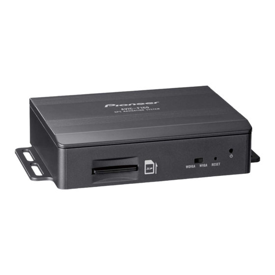
Checking part names and functions
Identifies and describes the physical components and controls of the system.
Notes before using the system
Important points to consider before operating the navigation system.
Inserting an SD memory card
Procedure for inserting the SD memory card required for system operation.
Resetting the microprocessor
Instructions on how to reset the system's microprocessor under specific conditions.
Getting Started with Your Navigation System
On first-time startup
Detailed steps for the initial setup process upon first use.
Regular startup
Procedure for starting the navigation system during normal use.
Navigating the System Menus
Screen switching overview
Overview of navigation screen layouts and basic interaction methods.
What you can do on each menu
Explains functions accessible from various menu screens.
Operating list screens (e.g. route settings screen)
How to navigate and interact with list-based menu screens.
Operating the on-screen keyboard
Instructions for using the virtual keyboard for text input.
Monitoring the GPS reception quality
How to check the status and accuracy of GPS signal reception.
Understanding the Map Display
How to read the map screen
Explains the various elements and information displayed on the map screen.
Frequently shown route events
Explains common icons and symbols used to indicate route events.
Seeing the current position on the map
How to locate and understand your vehicle's current position on the map.
Checking the detailed information about the current position
Accessing detailed information like coordinates and address for the current location.
Browsing the data field
How to view and cycle through navigation data fields on the map.
Display during motorway driving
Specific map displays and information shown during motorway navigation.
Changing the scale of the map
How to adjust the zoom level and map display scale.
Smart Zoom
Explains the automatic zoom feature based on driving conditions.
Changing the view angle of the map
How to adjust the vertical perspective of the map display.
Scrolling the map to the position you want to see
How to manually move the map to view different areas.
Viewing information about a specified location
How to get details about points of interest or other map markers.
Finding Your Destination
Searching for a location by address
Step-by-step guide to finding a location using its street address.
Searching for a location by entering the midpoint of a street
How to find a location by specifying the middle point of a street.
Searching for a location by entering the city/town centre
How to search for a location by selecting the city or town center.
Finding the location by specifying the postcode
How to locate a place using its postal code.
Searching for Points of Interest (POI)
How to find various points of interest like stations, restaurants, etc.
Searching for POIs using "Quick Search"
How to quickly find favorite places by name using a search feature.
Searching for POIs using preset categories
How to find POIs by selecting from predefined categories.
Searching for POIs by categories
How to search for POIs by selecting specific categories and subcategories.
Searching for a POI directly from the name of the facilities
How to search for Points of Interest by entering their specific names.
Searching for a nearby POI
How to find Points of Interest located in your immediate surroundings.
Selecting a location by using "Find on Map"
How to choose a destination by directly interacting with the map display.
Selecting destination from stored locations
How to select previously saved locations as destinations for quick routing.
Selecting a location you searched for recently
Accessing destinations or waypoints that were recently used.
Searching for a location by coordinates
How to pinpoint a location by entering its latitude and longitude.
Searching for a location by scrolling the map
How to specify a destination by manually navigating and selecting on the map.
Setting Your Route
Setting a route to your destination
Procedures for setting a route using a searched location or "My Route" menu.
Setting a route using a searched location
Step-by-step process to set a route after finding a destination.
Checking route alternatives when planning the route
How to compare different route options and planning methods.
Setting a route using the “My Route” menu
How to create or modify routes using the "My Route" menu.
Managing Your Route
Displaying the route overview
How to view the entire calculated route on the map with additional details.
Checking route parameters and accessing route related functions
How to check route details and access various route management functions.
Modifying the route calculation conditions
How to adjust settings that affect route calculation, like vehicle type.
Setting the vehicle parameters
How to edit vehicle profile settings to optimize route calculations.
Setting the route calculation
How to configure route calculation settings like navigation mode and planning method.
Changing road types used
How to include or exclude specific road types from route planning.
Setting the waiting time at waypoints
How to specify waiting times at waypoints for more accurate arrival estimates.
Setting driving time alerts
How to set up alerts for driver breaks based on continuous driving time.
Selecting a new destination when a route is already set
Options when selecting a new destination with an active route.
Setting a new starting position for the route
How to change the starting point for route planning.
Editing the list of destinations
How to add, remove, or reorder destinations in a route.
Cancelling the current route guidance
Procedure to stop the active route guidance and clear the route.
Checking route alternatives for the current route
How to compare different route options for the current journey.
Watching the simulation of the route
How to run a simulated navigation to preview the route.
Navigating in off-road mode
How to switch the navigation system to off-road mode.
Managing Locations
Storing a location in "Favourites"
How to save frequently visited locations for quick access.
Saving a location as an alert point
How to mark locations with alerts like speed cameras or warnings.
Editing an alert point
How to modify previously saved alert points and their settings.
Traffic Information Features
Checking historical traffic information
How to enable and use past traffic data for route planning.
Receiving real-time traffic information (TMC)
How to enable and use the TMC receiver for live traffic updates.
Checking the traffic incidents on the map
How to view traffic incidents and their severity displayed on the map.
Personalizing Your System
Displaying the settings screen
How to access the main settings menu to adjust system preferences.
Setting the volume and the guidance voice for navigation system
How to adjust audio volume, voice prompts, and language for navigation.
Customising the quick menu
How to personalize shortcuts for frequently used menu items.
Setting the traffic information
How to configure traffic information settings, including historical data and TMC.
Setting the user profiles
How to create and manage user profiles for personalized settings.
Customising the map screen settings
How to adjust the visual appearance of the map, including themes and 3D elements.
Setting the visual guidance
How to configure visual cues and information displayed on the map screen.
Customising the display settings
How to adjust screen brightness, menu animations, and other display options.
Customising the regional settings
How to set language, units, time/date formats, and time zone.
Setting the Trip Monitor
How to manage trip logs and track saving for journey data.
Starting the configuration wizard
How to restart the initial setup wizard to reconfigure basic settings.
Resetting to the default settings
How to restore all system settings and data to factory defaults.
Additional System Features
More menu
Access to additional options and applications like settings, converters, and help.
System Installation Guide
Important safeguards
Critical warnings regarding professional installation and user safety.
Precautions before connecting the system
Safety advice and warnings related to wiring and electrical connections.
Before installing this product
Essential steps and warnings to follow before starting the installation process.
To prevent damage
Warnings and precautions to avoid damaging the product or vehicle during installation.
Precautions before installation
Further safety guidelines on physical placement and component compatibility.
Connecting the system
Diagrams and instructions for connecting the navigation unit to the AV receiver and power.
Installing with the hook and loop fastener
Method for mounting the navigation unit using hook and loop fasteners.
Appendix and Technical Information
Positioning technology
Explanation of how the system uses GPS for location determination.
Positioning by GPS
Details on the Global Positioning System and its accuracy factors.
Handling large errors
Information on how positioning errors are minimized and potential issues.
When positioning by GPS is impossible
Conditions and reasons why GPS positioning might fail.
Conditions likely to cause noticeable positioning errors
Factors that can lead to inaccuracies in the displayed vehicle position.
Route setting information
Information on how the navigation system calculates routes based on map data and rules.
Route search specifications
Details the built-in rules and logic used for route calculation.
Auto reroute function
How the system automatically recalculates routes when deviating from the set path.
SD and SDHC logo
Information about SD and SDHC card trademarks.
Display information
An index of various features and their corresponding page numbers.
Glossary
Definitions of common terms used in the manual.
Specifications
Technical specifications of the navigation system hardware.
Need help?
Do you have a question about the AVIC-F260-2 and is the answer not in the manual?
Questions and answers