
Related Manuals for Lowrance Elite 4 DSI


Summarization of Contents
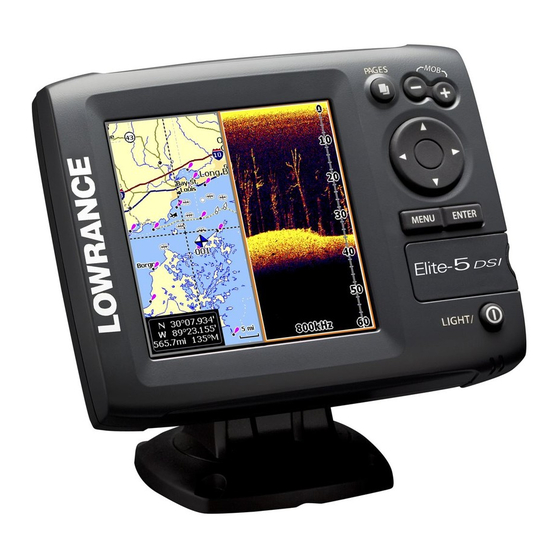
Introduction
Unit Controls
Details on device buttons: LIGHT/POWER, KEYPAD, PAGES, MENU, ENTER, ZOOM, MOB.
Getting Started
Initial setup steps: turning unit on/off, setting Man Overboard waypoint, adjusting backlight, muting audio.
Inserting and Removing microSD Cards
Instructions for inserting and removing microSD cards into the unit's slot.
Basic Operation
Setup Wizard
Guides through initial unit setup. Can be restarted by restoring defaults.
Pages Overview
Overview of the four available pages: Steer, Chart, Chart/DSI, and DSI.
Selecting Pages
How to navigate between different display pages using the keypad.
Page Menus
Accessing context-sensitive menus for Steer, DSI, Chart, and Chart/DSI pages.
Accessing Settings and Menus
How to open menus, access items, and work with scrollbars, on/off features, dropdowns.
Dialogs and Text Entry
User input dialogs and methods for entering text for functions like naming waypoints.
Cursor and Navigation
Using the keypad to move the cursor for map scrolling, item selection, and goto cursor.
Advanced and Standby Modes
Enables advanced features and settings, and lowers power consumption in Standby mode.
Restore Defaults and Display Adjustment
Resets unit settings to defaults and adjusts display contrast and color.
Pages
Steer Page
Displays compass, current track, destination direction, and navigation data.
DSI Page
Displays the water column data moving from right to left on the screen.
Chart/DSI Page
A split-screen view combining Chart and DSI data.
Chart Page
Displays real-time map data with North at the top.
Chart/Sonar Split
Configures how Chart and Sonar panels are displayed in a split screen.
Overlay Data
Enables/disables display of selected data on the sonar or chart page.
DSI
Using DSI and Sonar History
Overview of DownScan Imaging (DSI) features and reviewing sonar history via Trackback.
DSI Menu
Accessing the menu for DSI settings like contrast, frequency, and color.
Waypoint Creation and Contrast
Placing waypoints and adjusting screen contrast for better object visibility.
Range Setting
Sets the deepest range displayed, showing the water column from surface to depth.
Custom Range, Frequency, and Color
Adjusting custom depth range, transducer frequency, and color palettes.
Split Zoom
Changes display to a split zoom view for detailed examination of sonar data.
Surface Clarity and Stop Sonar
Reduces surface clutter and pauses sonar display for detailed inspection.
DSI Interpretation
Understanding DSI Images
Identifying sonar images like baitballs, pipes, bridge pilings, and baitfish.
Chart
Using Your Chart
Covers chart operation, saving, loading, and navigating waypoints, routes, and trails.
Chart Menu and Waypoint Creation
Accessing the chart menu and creating new waypoints at current location or cursor.
Waypoints, Routes, and Trails Management
Tools for creating, editing, navigating, and deleting waypoints, routes, and trails.
Waypoint Sorting and Route Screen
Sorting waypoints and accessing the interface for managing routes.
Creating a Route
Steps to create a route by inserting waypoints or selecting points directly on the chart.
Navigating Routes
Instructions for navigating routes in forward or reverse direction.
Creating Routes from Chart Points
Method to create routes by selecting points directly on the chart screen.
Route Menus and Deletion
Editing routes, setting names, controlling display, and deleting routes.
Trails Screen and Creation
Interface for managing trails and customizing trail name and color.
Trail Menus and Navigation
Editing trails, selecting names/color, and saving trails as routes for navigation.
Chart Overlay Data and Settings
Selecting data to display on the chart and accessing chart settings.
Map Orientation
Setting map orientation to North Up or Course Over Ground (COG).
Settings
System Configuration
Adjusting unit settings like language, mute audio, time, and GPS status.
Connectivity and Status
Configuring Data port, GPS source, and Chart/Sonar split display.
Advanced Mode and File Management
Enabling advanced features, restoring defaults, browsing files, and saving screenshots.
Navigation Settings
Controlling Arrival Radius, Off Course distance, and WAAS/MSAS/EGNOS.
Bearing and Variation Settings
Setting bearing calculation to True/Magnetic North and magnetic variation.
Chart Display Options
Controlling map data sources and display settings like grid lines.
Chart Display Features
Enabling COG Extension, Grid Lines, and Waypoints/Routes/Trails display.
Sonar Settings
Adjusting sonar settings like noise rejection and manual mode.
Calibration and Alarms
Setting up keel offset, temperature calibration, and navigation alarms.
Units, NMEA Output, and Simulator
Selecting units of measure, NMEA 0183 sentences, and using the simulator.
Specifications
Elite 5 DSI Specifications
General, power, and communication specifications for the Elite 5 DSI model.
DSI Sonar Specifications
Specifications for the DownScan Imaging sonar system, including depth and frequency.
Elite 4 DSI & Mark 4 DSI Specifications
General, power, and communication specs for Elite 4 DSI and Mark 4 DSI models.
Need help?
Do you have a question about the Elite 4 DSI and is the answer not in the manual?
Questions and answers