Nextar SNAP3 Software Instruction Manual
Automotive navigation system (gps)
Hide thumbs
Also See for SNAP3:
- Quick manual (1 page) ,
- Hardware instruction manual (42 pages) ,
- Hardware instruction manual (41 pages)
Table of Contents
Advertisement
Quick Links
Download this manual
See also:
Quick Manual
Advertisement
Table of Contents

Related Manuals for Nextar SNAP3


Summary of Contents for Nextar SNAP3
-
Page 3: Table Of Contents
contents Getting started ........………………………………………..……..2 Starting the system....……………………………………………………....2 Getting a GPS signal......….………………………………..... 3 Entering data on the system .…………………………………………….....4 Moving through the screens..……………………………………......5 Working with the map....……………………………………......6 Map view .......…………………………………….......... 6 Maneuver detail..……………………………………..........6 Panning the map ....………………………………………........6 Route list .......………………………………………........ -
Page 4: Getting Started
Getting started Congratulations on your purchase of the system. Your system can guide you to the destination of your choice using signals from Global Positioning Satellites (GPS) orbiting the earth. There are 24 GPS satellites orbiting the earth. A GPS device can calculate your position on the earth if it can receive signals from at least three of these satellites. -
Page 5: Getting A Gps Signal
To start the system: Press the POWER button. The screen appears. Tap Navigate. A warning screen appears. Tap “I Agree” after you have read and agreed to the warning. The map view appears and you are ready to set your first destination! Getting a GPS signal To use the system to guide you to a destination, the system’s GPS antenna must be receiving signals. -
Page 6: Entering Data On The System
To check the status of your GPS signal: Tap the Menu button and then Settings. Tap GPS Info. The GPS Info screen appears. To close the GPS Info screen, tap Entering data on the system The system doesn’t have a keyboard. Instead, you tap the screen to enter data. When you are entering data, a screen containing the letters of the alphabet appears: As you tap the buttons on the keyboard, the list at the top of the screen scrolls to show the next item that matches the letters you’ve tapped. -
Page 7: Moving Through The Screens
Moving through the screens The system shows you one screen at a time. Each time you tap a button, a new screen appears. If you want to return to the previous screen, tap . If there isn’t , you can Tap MENU to display the main menu. -
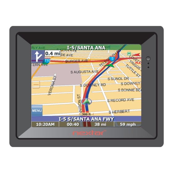
Page 8: Working With The Map
Working with the map The system gives you many ways of looking at the map. You can see your current position, you can view any of the maneuvers on a route, and you can pan the map to view other areas. You can zoom in and out, and you can find information about specific locations. -
Page 9: Route List
Route list Tapping an item on the list and then tapping Map will display the maneuver detail screen for that maneuver. Location and POI information You can find location information about any point on the map by pressing firmly on the map. - Page 10 To view location information: To view information about a location on the map, press firmly on the map. The address information screen appears. Tap Information. The Information screen appears, giving you block information about the location, including latitude and longitude. To view POI information: To view information about a POI on the map, press firmly on the icon on the map.
-
Page 11: Planning Your Route
Planning your route You can set a destination with the system many different ways. Once you have set a destination, you can add a detour or a stopover. The system also offers an Itinerary feature, where you can enter up to 50 destinations and use the Itinerary screen to move the addresses into any order you like. -
Page 12: Using An Address As A Destination
Using an address as a destination When you use an address for a destination, you must know at least the name of the street and the city. Guidance directions will be more accurate if you also know the street number of the destination. Note: If you already have a destination, you can tap New to set a new destination. - Page 13 Tap Street First. The Enter Street Name screen appears. Tap the letters to enter the name of the street. Tap OK when you have selected the street. The Enter House Number screen appears. Select the address that matches the location you want to go to and tap Nav. The map appears, and the guidance directions begin.
- Page 14 Tap Address. The Input Method screen appears. If you need to change the region: Tap Change State. The Enter State Name screen appears. Tap the letters to enter the name of the region, or tap the name of the region. Tap OK when you have selected the region.
-
Page 15: Using An Intersection As A Destination
Tap the numbers to enter the house number. Tap OK when you have finished. The Select Address screen appears. Select the address that matches the location you want to go to and tap Nav. The map appears, and the guidance directions begin. Using an intersection as a destination When you use an intersection for a destination you must know the names of both streets. - Page 16 If you need to change the region: Tap Change State. The Enter State Name screen appears. Tap the letters to enter the name of the region, or tap the name of the region. Tap OK when you have selected the region. You return to the Input Method screen.
- Page 17 To enter an intersection as a destination using City First: Tap MENU. The main menu appears. Tap Destination. The Set Destination screen appears. Tap Intersection. The Input Method screen appears. If you need to change the region: Tap Change State. The Enter State Name screen appears.
- Page 18 Tap the letters to enter the name of the city. Tap OK when you have selected the city. The Enter Street screen appears. Tap the letters to enter the name of the street. Tap OK when you have selected the street. The Enter 2nd Street Name screen appears.
-
Page 19: Using A Point Of Interest (Poi) As A Destination
Using a Point of Interest (POI) as a destination There are many points of interest that you can select as a destination. Generally, you choose a category and then choose one of four methods of selecting the specific point of interest. - Page 20 Tap a subcategory. The POI Options screen appears. To select a nearby POI from an alphabetical list: Tap Alphabetical. The Enter POI Name screen appears. Tap the letters to enter the name of the POI. Tap OK when you have selected the POI. The POI Select screen appears, displaying the address of the POI.
- Page 21 To select from all POIs in a region: Tap MENU. The main menu appears. Tap Destination. The Set Destination screen appears. Tap POI. The Points of Interest screen appears. Tap a category. Usually a subcategory screen appears. Note: If you chose Restaurant, tap the letters to enter a type of restaurant.
- Page 22 To select a POI from an alphabetical list: Tap List All. The Enter POI Name screen appears. Tap the letters to enter the name of the POI. Tap OK when you have selected the POI. The POI Select screen appears. Tap Nav.
-
Page 23: Using Poi Ca Lli Ng
How to call a POI from the GPS device via Bluetooth: Make sure your cell phone is paired with the GPS device via Bluetooth. (See hardware manual for details) Tap MENU. The main menu appears. Tap Destination. The Set Destination screen appears. Tap POI. - Page 24 To select a nearby POI from an alphabetical list: Tap Alphabetical. The Enter POI Name screen appears. Tap the letters to enter the name of the POI. Tap OK when you have selected the POI. The POI Select screen appears, displaying the address of the POI. Tap Call.
-
Page 25: Using A Favorite Destination As A Destination
Using a Favorite destination as a destination Favorite destinations are locations you add to a list on the system. You can add locations to your Favorites list as you set a destination, from the POI(S) screen, and from the Location Information screen. You can then easily select one of these locations as a destination. -
Page 26: Using A Recent Destination As A Destination
Using a Recent destination as a destination Recent destinations are locations you have navigated to recently. You can easily select one of these locations as a destination. Managing your recent destinations list is covered later in this section. To select a destination from your list of recent destinations: Tap MENU. -
Page 27: Using A City Center As A Destination
Using a City Center as a destination Sometimes you may want to use the system to get to a city, but not to a specific location within the city. To do this you select a City Center as a destination. As with selecting a Point of Interest, there are several methods of selecting a city center: two for nearby city centers and one for all city centers in a region. -
Page 28: To Select From All City Centers In A Region
To select a nearby POI by distance: Tap By Distance. The City List screen appears, listing the closest city centers first. Tap the city that you want to go to and tap Nav. You may need to scroll down the list by tapping the scroll bar. -
Page 29: Adding Detours And Stopovers
Adding detours and stopovers The detour feature lets you tell the system about roads on a route that you do not want to use. Stopovers are stops you add to a trip to make prior to reaching your destination. Detours Once you have set a destination you can look at the list of streets and determine if you need to mark one or more as unavailable. -
Page 30: Stopovers
Stopovers Once you have set a destination you can add a stopover. Adding a stopover does not cancel your original destination. When you reach your stopover, you will be prompted to continue to your final destination. To create a stopover: Tap MENU. - Page 31 Tap Destination. The Destination Options screen appears. Tap Stopover. Tap X. A confirmation message appears asking if you want to continue to your final destination. Tap Yes. The map appears and navigation continues. - 29 -...
-
Page 32: Managing Your Favorites List
Managing your favorites list You can edit the destinations you add to your favorites list to give them descriptive names. You can also remove destinations from your favorites list. To manage your favorites list: Tap MENU. The main menu appears. Tap Favorites. -
Page 33: Using Shortcuts
Using Shortcuts The shortcut feature provides you quick access to some of the most important destinations while you’re on the road, including: Home Hospital Parking Restaurant Tourist Information By tapping on any of the POI categories, you will see a list of the nearest POIs sorted by distance. -
Page 34: Setting Your Options
Setting your options You can set many different options to customize the system and make it work your way. These options include: display options route options speed alert volume localization Display options The display options give you control over the appearance of the map. You can change the following: orientation guidance... - Page 35 There are three options for displaying POI icons. If you choose default, the most commonly displayed categories of POI icons will appear on the map at zoom levels of 1000 ft and closer. If you choose off, no POI icons are displayed. If you choose custom, you can choose which categories of POI icons you want displayed.
-
Page 36: Route Options
To set your display settings: Tap MENU to enter main menu. Tap Display Options. The Display Options screen appears. Tap your Orientation preference: Heading or North. Tap your Guidance preference: Auto or Manual. Tap your Day/Night preference: Auto, Night, or Day. Tap your POI Icons preference: Default, Off, or Custom. -
Page 37: To Set Your Display Settings
There are four method settings. Quickest calculates the route that should take the least amount of time. Major calculates a route that uses major roads whenever possible. Shortest calculates the route that is shortest in distance. Local calculates a route that uses local roads whenever possible. -
Page 38: Speed Alert
Tap your Method preference: Quickest, Major, Shortest, or Local. Tap your Ferries preference: Include or Exclude. Tap your Toll Roads preference: Include or Exclude. Tap your Carpool preference: Include or Exclude. Tap your Turns preference: Reduced or Normal. When you have finished choosing your options, tap OK. Speed alert You can use the speed alert feature to warn you if your vehicle is exceeding the speed limit. -
Page 39: Volume
Volume You can set the volume used by your system to the level most comfortable for you. You can also mute the sound. There is also a Mute button on the Volume screen. To change the volume: Tap MENU. The Menu screen appears. Tap Settings. -
Page 40: To Set Your Localization Settings
There are three language settings. When you change the language, all of the screen names and controls will be in the selected language. There are six time zone settings, for all areas of United States. There are two daylight saving options, to determine whether or not daylight savings time is currently in effect at your location. - Page 41 Tap your Units preference: Mi or KM. Tap your TTS preference: Off, Mixed, or Exclusive. Off – Only recorded voice without pronouncing the street name. Mixed – Recorded voice with TTS for street name. Exclusive – FULL TTS (Default setting). When you have finished choosing your options, tap OK.
-
Page 42: Screen Display
Screen Display GUIDANCE SCREENS GPS Info Screen - 40 -... -
Page 43: Current Location Screen
Current Location Screen Route List Screen No part of this manual may be copied, republished, reproduced, transmitted or distributed in any way without prior written consent of Nextar, Inc. Any unauthorized - 41 -... - Page 44 Nextar Inc. 1661 Fairplex Dr. La Verne, CA 91750 © 2008 Nextar (Hong Kong) Limited. Nextar is a trademark and service mark of Nextar (Hong Kong) Limited. All other brand names, trademarks and service marks are property of their owners.
Need help?
Do you have a question about the SNAP3 and is the answer not in the manual?
Questions and answers