
Related Manuals for FLIR RAYMARINE A65


Summary of Contents for FLIR RAYMARINE A65
- Page 1 LightHouse™ OPERATION INSTRUCTIONS English (en-US) Date: 06-2017 Document number: 81360-5 © 2017 Raymarine UK Limited...
- Page 2 Printed Manuals Would you prefer a printed version of this document? Full documentation for your product is always provided as a free download on the Raymarine website, but some customers prefer manuals in a printed format. Raymarine provides a Print Shop service which enables you to purchase a printed manual (paperback book), delivered to your door.
- Page 3 Raymarine Belgium. FLIR, LightHouse, DownVision, SideVision, RealVision, Dragonfly, Quantum, Instalert, Infrared Everywhere, The World’s Sixth Sense and ClearCruise are registered or claimed trademarks of FLIR Systems, Inc. All other trademarks, trade names, or company names referenced herein are used for identification only and are the property of their respective owners.
-
Page 5: Table Of Contents
Contents Chapter 1 Important information... 19 Placing and moving the cursor Touchscreen location require- using touch..........35 ments............20 Touchscreen lock......35 Disclaimers..........20 Locking the touchscreen – Memory cards and chart cards....20 HybridTouch displays ......35 Third party software license Locking the touchscreen - touch only agreements .......... - Page 6 Resetting the homescreen to default Enabling the autopilot control function settings............ 41 — SeaTalk and SPX SeaTalk 3.9 Applications ........41 autopilots..........52 3.10 Screen overview......42 Enabling the autopilot control function Menus ............. 42 — Evolution autopilots ......52 3.15 Engine identification ......
- Page 7 Chapter 6 Document viewer Backing up user settings ......63 application..........87 Restoring user settings ......63 6.1 Document viewer overview ....88 4.2 Save and restore items ..... 64 4.3 Screenshots ........66 Opening the user manual......88 Opening a PDF document....... 88 Taking a screenshot ........
- Page 8 Vessel settings ........97 Cancelling the man overboard (MOB) Drive settings .......... 98 alarm ............117 Sail boat Settings ........99 Chapter 10 DSC VHF radio Aligning compass to GPS ....... 99 integration ..........119 7.11 Commissioning ......100 10.1 DSC VHF radio integration.... 120 10.2 Enabling DSC VHF radio Commissioning pre-requisites....
- Page 9 13.2 Routes ........... 150 Example scenario 1 — Own vessel moving faster than the target Route features........150 vessel ............ 133 Route building ........150 Example scenario 2 — Target vessel Automatic route generation ....153 moving faster than your vessel ..... 134 Review or edit a route ......
- Page 10 14.7 SAR (Search and Rescue) Enabling AIS in the Chart Patterns ..........173 application ..........185 Creating a Sector Search pattern... 173 Radar overlay........186 Drift effects on Sector Search Aerial photo overlay ......187 patterns ..........174 NOWRad weather overlay ....187 Creating an Expanding Square search Databoxes ..........
- Page 11 Tide information ........200 Setting the depth offset ......215 14.22 Depth & Contour options ..... 202 Setting the speed offset ......215 Setting the Temperature offset ....215 Depth soundings and contours ..... 202 15.7 Multiple sonar module 14.23 Navionics Advanced Menu support ..........
- Page 12 16.2 Pairing with a Quantum Radar Bottom Lock .......... 225 using Wi-Fi ..........245 15.16 SideVision Views ....226 Retain your Wi-Fi passcode ....245 Selecting a SideVision view ..... 226 Wi-Fi connection recovery..... 245 Selecting a SideVision view using 16.3 Switching the unit on and off..
- Page 13 Using the Radar range rings ....260 Setting up an instrument page 16.16 Radar mode and (Example)..........278 orientation..........260 17.3 List of data items ......279 Radar orientation modes....... 260 17.4 Engine identification ...... 282 Radar motion modes overview....261 Engine setup with an ECI 16.17 Radar Presentation menu ...
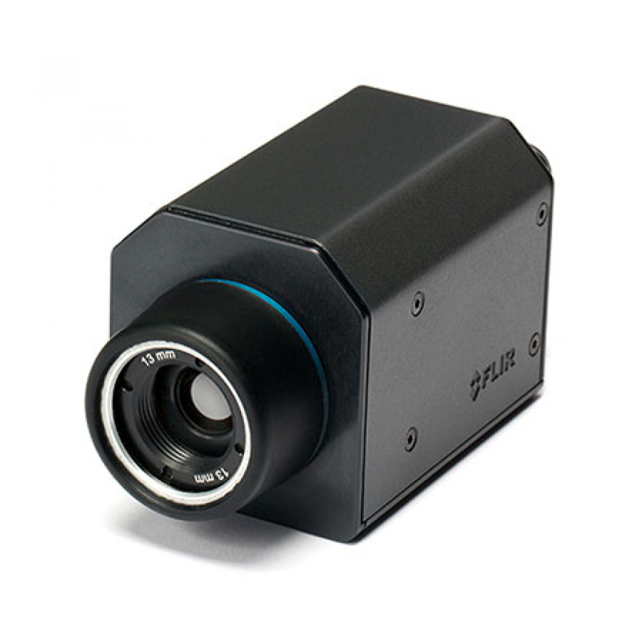
- Page 14 Turning off camera cycling ....293 Thermal camera surveillance 18.6 Naming camera / video mode ............. 306 feeds............294 Thermal camera stabilization ....306 18.7 Adjusting the video image ..... 294 Thermal camera point mode ....307 18.8 Selecting the aspect ratio ....295 19.6 Image adjustments ......
- Page 15 23.3 Pairing a Bluetooth media Thermal camera reverse video ..... 323 player............. 345 Thermal camera rear view mode... 323 23.4 Enabling audio control....345 20.7 Fixed mount camera menu.... 324 23.5 Media player controls ....346 Chapter 21 Wi-Fi and Mobile applications...........
- Page 16 26.4 Data Type Icons ......362 Viewing city weather forecasts....376 26.5 Selecting a storage location for 27.7 Weather reports......376 GRIB files ..........363 Displaying weather reports....376 26.6 Downloading and playing Changing the position of forecasts on (temporary) GRIB Files using touchscreen controls ......
- Page 17 Appendix A Switch panel application..........409 Appendix B NMEA 0183 sentences ..........411 Appendix C NMEA data bridging..412 Appendix D NMEA 2000 sentences ..........413 Appendix E Software releases .... 416 Appendix F Multifunction display compatibility ......... 424...
-
Page 19: Chapter 1 Important Information
Chapter 1: Important information Warning: Traffic separation Automatic route generation features Warning: Ensure safe do not adhere to the Traffic Separation navigation Schemes identified in Rule 10 of the International Regulations for Preventing This product is intended only as an aid Collisions at Sea 1972 as amended. -
Page 20: Touchscreen Location Requirements
Touchscreen location Caution: Sun covers requirements • If your product is supplied with a sun cover, to protect against the damaging Touchscreens offer an alternative to using physical effects of ultraviolet (UV) light, always buttons to control your display. Full product fit the sun cover when the product is functionality can be achieved using the Touchscreen. -
Page 21: Third Party Software License Agreements
Compatible cards It is important that you register your product to receive full warranty benefits. Your unit package The following types of MicroSD cards are compatible includes a bar code label indicating the serial number with your display: of the unit. You will need this serial number when •... -
Page 23: Chapter 2 Document And Product Information
Chapter 2: Document and product information Chapter contents • 2.1 Handbook information on page 24 • 2.2 Handbook conventions on page 25 • 2.3 Document illustrations on page 27 • 2.4 HybridTouch overview on page 27 Document and product information... -
Page 24: Handbook Information
2.1 Handbook information User manuals Print Shop Raymarine provides a Print Shop service, enabling This handbook contains important information you to purchase a high-quality, professionally-printed regarding your multifunction display. manual for your Raymarine product. The handbook is applicable to LightHouse Printed manuals are ideal for keeping onboard your powered multifunction displays. -
Page 25: Handbook Conventions
2.2 Handbook conventions The following conventions are used throughout this handbook when referring to: Type Example Convention Icons The term "select" is used in procedures involving icons to refer to the action of selecting an on-screen icon, either using touch or physical buttons: •... -
Page 26: Waypoint (Mob) Button / Icon
Waypoint (MOB) button / icon Depending on the multifunction display variant there will be either a Waypoint (MOB) button or an onscreen icon. • c Series button • e Series • eS Series • RMK-9 keypad • a Series icons •... -
Page 27: Document Illustrations
2.3 Document illustrations 2.4 HybridTouch overview Products may differ slightly from those shown in the If your multifunction display features HybridTouch, illustrations in this document, depending on product this enables you to operate the unit using the variant and date of manufacture. touchscreen and the physical buttons. -
Page 29: Chapter 3 Getting Started
Chapter 3: Getting started Chapter contents • 3.1 Switching the unit on and off on page 30 • 3.2 Controls on page 31 • 3.3 Basic touchscreen operations on page 35 • 3.4 Multi-Touch gestures on page 36 • 3.5 Touch icons on page 36 •... -
Page 30: Switching The Unit On And Off
3.1 Switching the unit on and off 4. You can wake the unit from PowerSave mode at anytime by pressing a physical button on the multifunction display. Powering the display on Note: PowerSave mode is automatically cancelled 1. Press the POWER button on the display. if an alarm event occurs. -
Page 31: Controls
3.2 Controls Description Functions Back Press to return to a previous menu or a Series Controls dialog level. WPT / MOB • Press and release to access the waypoint options. Press again to place a waypoint. • Press and hold to place a Man Overboard (MOB) marker at your current position. -
Page 32: Es Series Controls
UniControl Description Functions Non-touch, HybridTouch and the remote keypad WPT / MOB • Press and release to access the include a UniControl which consists of Rotary, waypoint options. Press again to place Joystick and a push button control. a waypoint. •... -
Page 33: Gs Series Controls
eS Series UniController Description Functions Touch- you can touch the screen to operate screen many common functions, including all menu operations. Home Press to return to the Homescreen. Menu Accesses menus. Press again to close menus. UniControl Provides rotary and joystick control. Ok push button Back Press to return to a previous menu or... -
Page 34: Keypad Controls
Descrip- Configura- Display Momentary Press and tion Functions tion State press hold — Touch- Touch the screen to operate functions, Off / Standby * Power on screen including all menu operations. Multifunction Open Power off display Power • Press once to switch the unit on. Shortcuts / put into page... -
Page 35: Basic Touchscreen Operations
3.3 Basic touchscreen operations Unlocking the touchscreen - touch only displays Placing and moving the cursor To unlock the touchscreen of a touch only display when paired with a remote keypad follow the steps using touch below. To place or move the cursor around the screen on From the Homescreen: a touchscreen multifunction display follow the steps 1. -
Page 36: Multi-Touch Gestures
3.4 Multi-Touch gestures 3.5 Touch icons Touchscreen multifunction displays can use Raymarine a Series and gS Series multifunction the BACK and CLOSE icons to move between displays support multi-touch. the different levels of menus available in each Multi-touch means that the display is capable of application. -
Page 37: Homescreen Overview - Touch Only Displays
3.6 Homescreen overview — 3.7 Homescreen overview — Touch only displays HybridTouch and non-Touch displays The Homescreen provides a central point of access for your display's applications, data and settings. The Homescreen provides a central point of access for your display's applications, data and settings. •... -
Page 38: Accessing The Homescreen
Symbol Description Accessing the homescreen Autopilot calibration. The homescreen can be accessed from any application. To access the homescreen follow the steps below: Power steering active. 1. Select the homescreen icon on-screen. Accessing the homescreen Wind Vane mode is The homescreen can be accessed from any active. -
Page 39: Sonar Status Symbols
Symbol Description AIS unit is switched off, or not connected. AIS unit is in Silent Mode. AIS unit is in Silent Mode, with active alarms. AIS unit is connected and switched on, but has active alarms. 1. From the Homescreen, select Customize. 2. -
Page 40: Pages
3.8 Pages 4. If selecting Choose page the Homescreen is displayed. Pages are made up of 1 to 4 panes that are used to display applications on your multifunction display (MFD). Pages are accessed using the icons on the Homescreen. •... -
Page 41: Renaming A Page On The Homescreen
3.9 Applications 3. Select Swap Page. 4. Select the page icon that you want to move. Chart application — provides a 2D or 5. Select the page icon that you want to swap 3D graphical view of your charts to help positions with. -
Page 42: Screen Overview
3.10 Screen overview Sirius Audio application — control Sirius radio from your MFD. Only available in USA. User Manual — Opens the English version of the product user manual stored on the display. To open translated user manuals stored on memory card use the Doc Viewer. -
Page 43: Dialogs
Screen item Description Back • Displays with a touchscreen — Select the onscreen Back icon to go back to the previous menu. • Non–touchscreen or HybridTouch displays — Use the Back button to go back to the previous menu. Function icons — Some dialogs include icons which can be selected to access additional functions. -
Page 44: Edit Dialogs
4. Select the àèò key to enter the character. Decrease display brightness Increase display brightness Numeric menu items Power up / Power down Radar Numeric menu items display numeric data and Radar standby / Radar transmit enables you to either select a predefined value or to increase and decrease the value as required. -
Page 45: Using Slider Bar Controls
3.11 Splitscreen controls Using slider bar controls Slider bar controls provide a graphical representation When viewing a page with more than 1 application of numeric data and enables you to quickly change displayed you can switch applications from the setting values. splitscreen view to fullscreen view. -
Page 46: Expanding And Retracting A Splitscreen Application
3.12 Initial set up procedures to switch the active application between full and splitscreen. Once your display has been installed and commissioned, Raymarine recommends that you 3. Press the Back button or the Switch Active complete the Startup wizard and perform some button to exit switch mode. -
Page 47: Minimum Safe Beam
i.e.: Minimum Safe Depth = Maximum Vessel Draft + Safety Margin. 1. Port safety margin 2. Maximum Vessel Width (Beam) 1. Waterline 3. Starboard safety margin 2. Maximum Vessel Draft Important: The information below is provided 3. Safety Margin for guidance only and is not exhaustive. Some 4. -
Page 48: Setting The Vessel Minimum Safe Depth, Beam And Height
• Routes and waypoints Important: The information below is provided for guidance only and is not exhaustive. Some • Radar influencing factors can be unique to certain vessels • Sonar and / or areas of water and may not be listed below. - Page 49 Resolving Data master lost 3. Select Data Master. If the current Data master cannot be found by the system then an alarm is triggered. The Data master may become temporarily unavailable under certain circumstances, such as if the MFD is rebooting after a software update of power cycle.
-
Page 50: Gnss Status
3.13 GNSS Status accuracy, calculated from a number of factors including satellite geometry, system errors in The GPS status page enables you to view the status the data transmission and system errors in the of the available satellites that are compatible with receiver. -
Page 51: Satellite Based Augmentation Systems (Sbas)
• COMPASS / Beidou-2 — Chinese Regional Status / Navigation Satellite System (Beidou) is currently Type Name Compatible receivers being expanded for global coverage (COMPASS All internal and external Raymarine Oper- WAAS or Beidou-2) by 2020. ational GPS receivers and GNSS receivers SBAS Satellite based augmentation systems All internal and external Raymarine... -
Page 52: Cog/Sog Filter
3.14 Enabling autopilot control Choosing differential satellites You can select which constellations of SBAS your Enabling the autopilot control function receiver will use. — SeaTalk and SPX SeaTalk From the GPS Set-up menu: Homescreen > Set-up > System Settings > GPS Set-up: autopilots 1. -
Page 53: Engine Identification
3.15 Engine identification Engine data can be displayed on your MFD using the Data application, which provides some preset Engine pages for displaying some of the most common types of engine data. Important: Before you can display Engine data on your MFD, you must: •... -
Page 54: Engine Setup With An Eci Interface
Engine setup with an ECI interface Before you can display engine data on your MFD, you may need to use the "Engine Identification wizard” on the MFD to setup the engines. Important: When setting up on a multiple engine system, engines should always be turned on in sequence from port to starboard. -
Page 55: Enabling Ais Functions
3.16 Enabling AIS functions 3.17 Shared preferences Before proceeding ensure your AIS unit is connected The Shared preferences scheme allows all to NMEA Port 1. compatible networked MFDs and instrument displays to share user preference settings. With the homescreen displayed: When a user preference is changed on 1 display 1. -
Page 56: Memory Cards And Chart Cards
3.18 Memory cards and chart 3.19 Simulator mode cards The Simulator mode enables you to practice operating your display without data from a GNSS MicroSD memory cards can be used to back up / receiver, Radar scanner, AIS unit, or Sonar module. archive data (e.g. -
Page 57: System Software Updates
3.20 System software updates Note: When connected to a Quantum Radar using a Wi-Fi connection a, c, e and gS Series Raymarine regularly issues software updates for MFDs cannot connect to a Wi-Fi Access point at its products that can provide new and enhanced the same time. -
Page 58: Performing Software Updates
• A FAT 32 formatted MicroSD card with SD card If a software update is available on the memory card the Update? box is automatically ticked. adaptor. 5. On touchscreen displays you can select and hold Note: Do not use a cartography chart card for on the available software version to see further software updates or user data / settings backups. -
Page 59: Pairing The Keypad
3.21 Pairing the keypad 3.22 Learning resources Each keypad can be paired with multiple MFDs and Raymarine has produced a range of learning multiple keypads can be connected to the same resources to help you get the most out of your system. -
Page 61: Chapter 4 Managing Display Data
Chapter 4: Managing display data Chapter contents • 4.1 Saving user data and user settings on page 62 • 4.2 Save and restore items on page 64 • 4.3 Screenshots on page 66 • 4.4 Resetting your system on page 66 Managing display data... -
Page 62: Saving User Data And User Settings
4.1 Saving user data and user 2. Select My Data. settings 3. Select Import/Export. 4. Select Save Data. User data, settings and media files can be saved 5. Select Save All. to a memory card. The onscreen keyboard is displayed. Waypoints, routes and tracks are saved in 6. -
Page 63: Erasing User Data Files From A Memory Card
3. Select SD1 (single or top card reader slot) or SD2 3. Browse to and select the file you want to import. (bottom card reader slot). A confirmation dialog is displayed. A confirmation dialog is displayed. 4. Select OK. 4. Select OK. Erasing user data files from a memory Restoring user settings card... -
Page 64: Save And Restore Items
4.2 Save and restore items Menu Setting The table below details the data items and settings Customize > Databar Set-up Databar content (cell 1 to 6) which will be saved to and restored from a memory Compass in titlebar card on your multifunction display. Status Icon Bar Homescreen and settings Databar Autohide... - Page 65 Data application Menu Setting Menu Setting Databox 2 Datapages and content Databox 2 content Presentation Color theme Presentation > Vectors Vector length Dial color Vector width Number of engines Presentation > Objects Show rocks Maximum RPM range Nav marks Nav marks symbols Weather application Light sectors Menu...
-
Page 66: Screenshots
4.3 Screenshots 4.4 Resetting your system You can take a screenshot of what is currently Your system may be reset to its factory default displayed on the screen. settings if required. Screenshots are saved in .png (Portable Network There are 2 types of reset operation, both of which Graphic) format to a MicroSD Card. -
Page 67: Chapter 5 Customizing Your Display
Chapter 5: Customizing your display Chapter contents • 5.1 Language selection on page 68 • 5.2 Boat details on page 69 • 5.3 Units set-up on page 70 • 5.4 Time and Date set-up on page 71 • 5.5 Display preferences on page 72 •... -
Page 68: Language Selection
5.1 Language selection The system can operate in the following languages: English (US) English (UK) Arabic Bulgarian Chinese — Chinese — Simplified Traditional Danish Croatian Czech Dutch Finnish French German Greek Hebrew Hungarian Icelandic Indonesian Italian Japanese Korean Latvian Lithuanian Malay Norwegian Polish... -
Page 69: Boat Details
5.2 Boat details You can customize various settings to make them specific to your vessel. Menu item Description Options Boat Type You can change the appearance of the vessel • Power Cruiser 1 (default) in the chart application. Select the option that •... -
Page 70: Units Set-Up
5.3 Units set-up You can specify your preference for the units of measurement that will be used in all applications. Menu item Description Options Distance Units The units of measure that will be used in all • Nautical Miles applications for the display of all values related •... -
Page 71: Time And Date Set-Up
5.4 Time and Date set-up You can specify your preference for the way that time and date will appear in all applications. Menu item Description Options Date Format Allows you to specify the preferred format for the • MM:DD:YY (Month, Day, Year) display of date information in all applications. -
Page 72: Display Preferences
5.5 Display preferences You can specify your preference for general display behavior. Menu item Description Options Starting page Allows you to select what page the display opens • Homescreen at start up. • Last page — After power up the last used page is displayed. -
Page 73: Onscreen Range Controls
Onscreen range controls Setting up shared brightness You can enable and disable onscreen range controls With the homescreen displayed: on HybridTouch displays by following the steps 1. Select Customize. below. 2. Select Display Preferences. From the Homescreen: 3. Select Shared Brightness. 1. -
Page 74: Databar And Databox Overview
5.6 Databar and databox overview Auto-hide the databar On multifunction displays that have a touchscreen, You can customize the data displayed in the databar the databar that is displayed at the top of all and onscreen databoxes. applications pages can be set to auto-hide. This Customizable data is displayed in the databar, provides a larger screen area for the application extended databar (HybridTouch displays only) or... -
Page 75: Customizing The Databar
Customizing the databar From the homescreen: 1. Select Customize. 2. Select Databar Set-up. 3. Select Edit Databar. 4. In the databar, select the cell that you want to change. The Select Data Category menu will be displayed. 5. Select the category that reflects the type of data you want to display in the cell. -
Page 76: Set-Up Menu Options
5.7 Set-up menu options The Set-up menu enables you to configure your MFD and connected devices. The following menus are available: Menu item Description Notes Touch-Lock Enables you to lock the touchscreen of a • ON touch only display when the display is paired •... -
Page 77: Ground Trip Resets Menu
Ground trip resets menu This menu enables you to resets the chosen ground trip distance counter to zero. Menu item Description Ground Trip 1 Reset Resets the ground trip 1 distance counter to zero. Ground Trip 2 Reset Resets the ground trip 2 distance counter to zero. Ground Trip 3 Reset Resets the ground trip 3 distance counter to zero. -
Page 78: Data Sources Menu
Data sources menu This menu enables you to select the external sensors and devices that will provide data to the display. Auto / manual selection Each dialog enables you to view and select your preferred data source. selection of data source can be manual or set to automatic: •... -
Page 79: External Devices Menu
External devices menu This menu enables you to configure the external devices connected to the display. Menu item Description Options Pilot Set-up When connected to an Evolution autopilot this option allows you to enable and disable pilot control and the pilot bar. You can also access certain pilot settings and modes. -
Page 80: Wireless Connections Menu
Wireless Connections menu This menu provides access to the MFD’s Bluetooth and Wi-Fi functions. Bluetooth Menu item Description Options Bluetooth Enable or disable Bluetooth on the display. • On • Off (default) Connection Manager Provides a list of Bluetooth devices in range. •... - Page 81 Menu item Description Options Enables you to select the type of mobile app in use: • Viewing only — RayView • Remote Control — RayRemote or RayControl Customizing your display...
-
Page 82: Nmea Set-Up Menu
NMEA Set-up menu This menu enables you to configure settings for NMEA devices. Menu item Description Options Bridge NMEA Heading If set to ON, NMEA heading data will be bridged • On onto the SeaTalk data bus, and will be sent to •... -
Page 83: System Preferences Menu
System preferences menu Menu item Description Options Bearing mode Determines how all bearing and heading data is • True (default) displayed in. This does not affect how the chart or • Magnetic radar displays are drawn. Variation Source This setting compensates for the naturally •... -
Page 84: Maintenance Menu
Maintenance menu This menu provides access to systems settings and diagnostics. Menu item Description Options Diagnostics Diagnostics provides detailed information on the • Select Device multifunction display and connected devices. The • Sirius range of information available includes product serial number, software version, and network •... -
Page 85: Diagnostics Menu
Diagnostics menu If you encounter problems with your multifunction display or peripheral devices you can use the Diagnostics menu to view information about your device and connected equipment. Menu Description Options Select Device Enables you to view a list of all devices •... -
Page 87: Chapter 6 Document Viewer Application
Chapter 6: Document viewer application Chapter contents • 6.1 Document viewer overview on page 88 Document viewer application... -
Page 88: Document Viewer Overview
6.1 Document viewer overview • Open File — Allows you to browse a MicroSD card or the MFD’s internal storage for a PDF You can view PDF documents on your multifunction document to open. display. • Go to page: — Allows you to jump to a specific The document viewer is available from the page number. -
Page 89: Browsing An Open Document
Selecting a page 2. Select Close file. The document is close and the main Doc viewer You can skip to the page you want to view by page is displayed. entering the page number. With a pdf document open: Browsing an open document 1. -
Page 90: Keyword Not Found
4. Select SAVE. The document viewer will enter find mode and: • You may see a ‘Searching’ icon while all occurrences are found. • The find tool bar is displayed. • The first occurrence of the keyword is highlighted. 5. Move the Joystick Down to go to the next occurrence of the keyword, or 6. -
Page 91: Chapter 7 Autopilot Control
Chapter 7: Autopilot control Chapter contents • 7.1 Autopilot Control overview and features on page 92 • 7.2 Enabling autopilot control on page 92 • 7.3 Pilot Control dialog on page 93 • 7.4 Pilot Bar on page 94 • 7.5 Pilot Set-up on page 95 •... -
Page 92: Autopilot Control Overview And Features
7.1 Autopilot Control overview 7.2 Enabling autopilot control and features Enabling the autopilot control function Raymarine autopilots can be controlled directly — SeaTalk and SPX SeaTalk ® from a compatible LightHouse powered MFD, with or autopilots without a dedicated Pilot control head. To enable control of your SeaTalk or SPX SeaTalk Note: For information on connecting a autopilot using your multifunction display follow the... -
Page 93: Pilot Control Dialog
7.3 Pilot Control dialog Description Pilot Status — Current pilot mode. The Pilot Control dialog can be used to control autopilot functions. Current Heading. Pilot Control dialog (standby) No (Standby) — Disengages the autopilot and returns to manual vessel control. The example below shows the Pilot Control dialog options when the dialog is opened from a menu or Rudder bar —... -
Page 94: Pilot Bar
7.4 Pilot Bar Stop Goto, Stop Follow or Advance Waypoint from the context menu. The Pilot Bar provides autopilot status information. 6. When you are following a route or going to a For touchscreen displays you can disengage the waypoint or cursor position, and select Menu autopilot using the Pilot Bar. -
Page 95: Pilot Set-Up
7.5 Pilot Set-up 7.6 Engaging the autopilot Caution: Maintain a permanent When connected to an Evolution autopilot the Pilot Set-up page is available. watch Automatic course control makes it easier to steer your vessel, but it is NOT a substitute for good seamanship. ALWAYS maintain a permanent watch by the helm. -
Page 96: Adjusting The Current Locked Heading
7.7 Adjusting the current locked 7.8 Disengaging the autopilot heading Caution: Disengaging the autopilot When the autopilot is in Auto mode the current locked heading can be adjusted from the Pilot On integrated multifunction displays that Control dialog and from the Pilot Bar. do not have a dedicated pilot button, With the Pilot Bar or Pilot Control dialog displayed: in an emergency the autopilot can be... -
Page 97: Track Mode
7.9 Track mode 7.10 Pilot settings The Pilot settings option is available on a data You can use track mode to automatically steer your master multifunction display when it is integrated vessel. with an Evolution autopilot. In Track mode, the autopilot automatically steers The Pilot settings enable the setup and your vessel to a target waypoint or along a route commissioning of an Evolution autopilot using a... -
Page 98: Drive Settings
type options, as it might be possible to improve the 1. Set your vessel on a known heading and check steering performance of your vessel by selecting a the steering compass. different vessel type. 2. Check the autopilot heading on your multifunction When choosing a suitable vessel type, the emphasis display. -
Page 99: Sail Boat Settings
the joystick is held over, the greater the applied Note: To perform this procedure it is desirable to rudder. have a networked device such as an instrument, pilot control head or multifunction display that can • Bang-Bang — Bang-bang modes applies display the current rudder position onscreen whilst continuous rudder in the direction of the joystick making this adjustment. -
Page 100: Commissioning
7.11 Commissioning 6. If the alignment is successful select OK to complete the procedure. You can commission an Evolution autopilot using If required this procedure will automatically correct the Pilot settings menu on your multifunction display. the compass offset value accessible from the Vessel All set-up and commissioning procedures must be Settings menu. -
Page 101: Performing The Dockside Wizard
Selecting a drive type and drive type. Therefore, the available vessel hull type options are provided for guidance only. You Drive type selection is available from the dockside may wish to experiment with the different vessel hull wizard, and also from the Vessel settings menu: type options, as it might be possible to improve the Pilot Set-up >... -
Page 102: Checking The Rudder Drive
Adjusting the hard-over time • If you already know the hard-over time for your vessel’s steering system: enter this time during On vessels without a rudder reference transducer, it the Dockside wizard procedure. is important to set the hard-over time limits correctly, •... -
Page 103: Compass Lock
process has successfully completed you can check the current deviation value at anytime from the diagnostics pages. Note: If “- -” is displayed as the Deviation value, it means that linearization has not been successfully completed yet. Check the compass heading data As part of the autopilot system commissioning process, it is recommended that you check the compass heading value displayed, against a good... -
Page 104: Autopilot Status Symbols
7.12 Autopilot status symbols 7.13 Autopilot alarms The autopilot status is indicated in the databar. The autopilot function provides alarms to alert you to situations that require action. Symbol Description Your multifunction display shows autopilot alarms, Autopilot is in Standby regardless of whether there is active navigation on mode. -
Page 105: Chapter 8 Alarm Management
Chapter 8: Alarm management Chapter contents • 8.1 Alarms overview on page 106 • 8.2 Alarm Manager overview on page 106 • 8.3 Alarm options on page 109 Alarm management... -
Page 106: Alarms Overview
8.1 Alarms overview 8.2 Alarm Manager overview Alarms alert you to a situation or hazard requiring The Alarm Manager is used to configure the behavior your attention, such as shallow depth or a change in of alarms and to manage alarm activity. water temperature. -
Page 107: Accessing The Alarm Manager
1. Select the Settings tab. 2. Select the alarm category for the alarm you want to enable / disable. Alarms are displayed in the Alarm Manager in the following categories: • Safety Alarms • General Alarms • * Switch Panel Alarms •... -
Page 108: Clearing The Alarm History
5. Select Yes. The alarm history is deleted. The alarm history is also cleared if a Systems and Data Reset is performed. 5. With the numeric adjust control displayed, select the on-screen Up and Down arrows to adjust the alarm threshold value, or 6. -
Page 109: Alarm Options
8.3 Alarm options Safety Alarms Menu item Description Options Waypoint arrival Enable: If enabled, when you arrive at a waypoint, an alarm is triggered. This setting allows you to specify the radius • Enabled (Ticked) (default) of the waypoint arrival circle. The waypoint arrival circle is an imaginary circle around the destination •... - Page 110 Menu item Description Options Dangerous AIS AIS target alarms can be enabled and disabled. With • Enabled (Ticked) targets the AIS target alarm disabled AIS targets will not trigger • Disabled (Un-ticked) (default) an alarm when they become dangerous. Anchor alarm (drift) Enable: When enabled, the Anchor Drift alarm is triggered when your vessel drifts from your anchor position by more...
- Page 111 Menu item Description Options • 00.00 to 23:59 hrs (hh:mm) Countdown Timer When enabled, counts down the time period specified Enable: in the Timer Period setting, and triggers an alarm • Enabled (Ticked) when zero is reached. • Disabled (Un-ticked) (default) Time Period •...
- Page 112 Menu item Description Options • –9.98°F to Upper Temp Limit Fish If the Fish alarm is enabled, an alarm tone is triggered Enable: if a target is detected that meets the Fish alarm • Enabled (Ticked) sensitivity. The following options are available under Fish Alarm. •...
- Page 113 Menu item Description Options • Not charging • High boost pressure • Rev limit exceeded • EGR system • Throttle position sensor • Emergency stop • Warning level 1 • Warning level 2 • Power reduction • Maintenance needed • Communications error •...
-
Page 115: Chapter 9 Man Overboard (Mob)
Chapter 9: Man Overboard (MOB) Chapter contents • 9.1 Man overboard on page 116 Man Overboard (MOB) -
Page 116: Man Overboard
9.1 Man overboard • MOB data is displayed in the databar, replacing the existing data. If you lose a person or object overboard, you can • MOB data is displayed on the homescreen, use the Man Overboard (MOB) function to mark replacing the status icons. -
Page 117: Cancelling The Man Overboard (Mob) Alarm - Touch Only Display
Cancelling the man overboard (MOB) alarm — Touch only display On a Touch only display you can cancel the MOB alarm and resume normal operation follow the steps below: 1. Press and hold the onscreen WPT / MOB icon for 4 seconds. The MOB alarm is cancelled and normal operation is resumed. -
Page 119: Chapter 10 Dsc Vhf Radio Integration
Chapter 10: DSC VHF radio integration Chapter contents • 10.1 DSC VHF radio integration on page 120 • 10.2 Enabling DSC VHF radio integration on page 120 DSC VHF radio integration... -
Page 120: Dsc Vhf Radio Integration
10.1 DSC VHF radio integration 10.2 Enabling DSC VHF radio integration You can connect your DSC VHF radio to your multifunction display and show distress message With the homescreen displayed: information and GPS position data for other vessels. 1. Select Set-up. Connecting a DSC VHF radio to your multifunction 2. -
Page 121: Chapter 11 Fuel Manager
Chapter 11: Fuel manager Chapter contents • 11.1 Fuel manager overview on page 122 Fuel manager... -
Page 122: Fuel Manager Overview
11.1 Fuel manager overview • Turn on the fuel manager feature. • Fill the fuel tanks to full. The fuel manager provides an estimate of fuel remaining, and the distance and time which can • Select ‘All tanks full’. be travelled before the tanks are empty. In order •... -
Page 123: Fuel Logging
Resetting fuel used readings 5. Select Economy Units. A list of available options is displayed: You can reset the value of the fuel used this season or fuel used this trip by following the steps below. • Distance per Volume From the fuel manager page: •... - Page 124 1. Select Menu. 2. Select Presentation. 3. Select Overlays. 4. Select Fuel Range Ring so that On is selected. The fuel range ring pop-up message is displayed. 5. Select OK to turn on the fuel range rings.
-
Page 125: Chapter 12 Ais (Automatic Identification System)
Chapter 12: AIS (Automatic Identification System) Chapter contents • 12.1 AIS overview on page 126 • 12.2 AIS prerequisites on page 127 • 12.3 Enabling AIS on page 128 • 12.4 AIS context menu on page 128 • 12.5 AIS vectors on page 129 •... -
Page 126: Ais Overview
12.1 AIS overview nm range. These targets are displayed using the appropriate AIS target's status symbol, and move around the screen as if they were real targets. AIS uses digital radio signals to transmit ‘real-time’ information between vessels and shore-based Note: Incoming safety messages are NOT stations via dedicated VHF radio frequencies. -
Page 127: Ais Prerequisites
12.2 AIS prerequisites Symbol Description AIS unit is switched off, or not You must have suitable AIS hardware connected to connected. your multifunction display to make use of the AIS functionality. AIS unit is in Silent Mode. In order to run AIS, you will need: •... -
Page 128: Enabling Ais
12.3 Enabling AIS 12.4 AIS context menu When an AIS target is selected, the Chart application Enabling AIS in the Chart application context menu includes AIS target information and menu options. To enable the AIS overlay in the Chart application follow the steps below. -
Page 129: Ais Vectors
12.5 AIS vectors Enabling and disabling AIS vectors From the Chart or Radar application: Vectors can be displayed for AIS targets. 1. Select an AIS target. The AIS target context menu is displayed. 2. Select AIS Vector. Selecting AIS Vector will switch between On and Off. -
Page 130: Vector Options
12.6 Vector options 12.7 Tracked target list The Vector options can be accessed from the All targets currently being tracked are shown in the Collision Avoidance menu. Tracked target list. MARPA and AIS targets are shown in separate tabs. The location of the Vector options is dependent on the application and the overlays you have enabled: The location of the Tracked target list is dependent on the application and Overlays you have enabled:... -
Page 131: Dangerous Targets
12.8 Dangerous targets • Show the target in the Chart application Selecting Cancel All Targets will remove “stop Targets are considered dangerous if the target will tracking all MARPA targets” in the list. You can also get closer than the specified Safe Distance within cancel individual targets by selecting the ‘X’... -
Page 132: Collision Avoidance
12.9 Collision Avoidance • Chart application with only the Radar overlay enabled: Menu > Radar > AIS Options > Display AIS: The Chart application provides features to help improve collision awareness. The Target interception • Chart application with only the AIS overlay feature tracks AIS targets in relation to your own enabled: Menu >... -
Page 133: Target Interception Pre-Requisites
5. Target — This is the last reported position of Warning: Collision Avoidance the target. and the IRPCS 6. Own vessel’s COG line The Collision Avoidance feature is a 7. Own vessel graphical aid provided to help increase user awareness of the potential for Example scenario 1 —... -
Page 134: Example Scenario 2 - Target Vessel Moving Faster Than Your Vessel
Example scenario 2 — Target vessel Scenario 1 Speed change examples moving faster than your vessel Note: These scenarios are examples provided for guidance only. In certain situations, when the target vessel is travelling faster than your vessel, there may be more than one opportunity for your paths to cross within the Intercept distance. -
Page 135: Example Scenario 3- Both Vessels Travelling At The Same Speed
Course change target’s Interception zone, and passes safely astern of the target. This manoeuvre also clearly When both vessels are travelling at the same speed, indicates to the target vessel your change of course alterations should be made in accordance course. -
Page 136: Rendez-Vous (Target Interception)
12.10 Rendez-Vous (Target Target interception graphics will now be displayed for the selected target, regardless of whether it will interception) cross your path or not. (If your paths will not cross then only the COG line will be displayed). The Intercept point is displayed when performing an individual Interception. -
Page 137: Displaying Safety-Critical Ais Information
12.11 Displaying safety-critical 3. Begin navigation to the Intercept point. AIS information Remember When the target moves the Intercept point will move accordingly. It will be necessary to change course so that your COG lines intersect From the chart or radar application: at the Intercept point. -
Page 138: Displaying Detailed Ais Target Information
12.12 Displaying detailed AIS 12.13 AIS silent mode target information AIS silent mode enables you to disable the transmitting functions of your AIS equipment. This From the chart or radar application: is useful when you do not want to transmit your 1. -
Page 139: Ais Safety Messages
12.14 AIS Safety messages 12.15 Buddy tracking Buddy Tracking enables you to add AIS-equipped With AIS Safety Messages switched On, any friends and regular contacts to a “Buddy List” on incoming safety messages from surrounding vessels, your MFD. When a vessel on your Buddy List is in shore stations and mobile stations are displayed in a range of your AIS unit, a Buddy icon is displayed dialog box. -
Page 140: Removing A Buddy
5. Select Edit Buddy Name to change the buddy name. This could be the name of the vessel, or the name of the friend who owns the vessel, for example 6. Enter the new details and select SAVE. You will be returned to the buddy list. Removing a buddy From the Chart or Radar application: 1. -
Page 141: Chapter 13 Waypoints, Routes And Tracks
Chapter 13: Waypoints, Routes and Tracks Chapter contents • 13.1 Waypoints on page 142 • 13.2 Routes on page 150 • 13.3 Tracks on page 160 • 13.4 Import and Export on page 162 • 13.5 Waypoints, routes and tracks storage capacity on page 162 Waypoints, Routes and Tracks... -
Page 142: Waypoints
13.1 Waypoints The default waypoint symbol is a red ‘X’. Alternative symbols can be used if required. Waypoints are used to mark specific locations or Waypoints in the Sonar application points of interest. Waypoints can be used in the Chart, Radar and Sonar apps. Your MFD can store Waypoints in the Sonar application are represented up to 3,000 waypoints which can be sorted into up by a vertical line labelled WPT. -
Page 143: Waypoint Context Menu
Waypoint context menu Placing the cursor over a waypoint in the Radar application or selecting and holding on a Waypoint in the Chart application displays the Waypoint context menu. 3. Select the Symbol field to change the symbol that will be used to display the waypoint in the Chart or Radar application. -
Page 144: Waypoints List
Placing a waypoint at your vessel's position 3. Select the Position field. In addition to positional information, a waypoint placed at the vessel position will capture temperature and sounded depth information (if you have the appropriate sensors connected to your system). From the Chart, Radar or Sonar application: 1. - Page 145 Import/Export. Refer to 4.1 Saving user data Renaming a waypoint group and user settings for details. With the Waypoint group list displayed: 5. All waypoints — Selecting ALL WAYPOINTS 1. Select the group you want to rename. displays a list of all waypoints saved on your Group details are displayed.
-
Page 146: Waypoint Information
Erasing all waypoints in a group • Position (Latitude and Longitude of the waypoint.) You can erase all waypoints in a selected group. • Bearing and Range (Bearing and range from vessel.) With the waypoint groups list displayed: 1. Select the group that contain the waypoints you •... -
Page 147: Erasing Waypoints
1. Select All Waypoints. • Area 2. Select the relevant waypoint. The waypoint information page is displayed. 3. Select the Position field. 4. Use the on-screen keyboard to make the changes, and then select the on-screen keyboard's SAVE key. Erasing waypoints Erasing a waypoint using the context menu With the application page displayed: 1. -
Page 148: Waypoint Symbols
4. Select Erase Wpts to erase the list of waypoints 9. Select Erase Wpts to erase the list of waypoints from your system, or from your system, or 5. Select Move Wpts to move the waypoints to a 10. Select Move Wpts to move the waypoints to a new or existing group, or new or existing group, or 6. -
Page 149: Showing And Hiding Waypoint Groups
Toilets Restaurant Ledge Fish Ramp Caution Fish 1 Star Fish 2 Star Green racemark Green Racemark Fish 3 Star School Fish anti-clockwise clockwise Yellow racemark Yellow Racemark Lobster Small Fish anti-clockwise clockwise Red racemark Red Racemark Rocks Reef anti-clockwise clockwise Marker Restriction Private Reef... -
Page 150: Routes
13.2 Routes 1. Select Show/Hide. A route is a series of waypoints typically used to assist with passage planning and navigation. A route is displayed on screen as a series of waypoints linked by a line. 2. Select the Group from the list that you want to show or hide. - Page 151 Note: If you place a waypoint at the wrong Building a route position, select Undo Waypoint. You can build a route on a touchscreen multifunction display by following the steps below. Building a route using the waypoint list From the chart application: 1.
- Page 152 If the pop-up is displayed, select Continue. Waypoint symbols with pre-defined rounding instructions The onscreen keyboard is displayed. Some waypoint symbols have pre-defined rounding 5. Enter the relevant racemark IDs, in order, using instructions that cannot be changed or removed. a comma to separate each ID that you want to include in your route.
-
Page 153: Automatic Route Generation
It can now be displayed, edited and erased etc. Important: The following restrictions apply: in the same way as other routes in the system. • Automatic route generation can only be used 3. Select OK to confirm. when generating routes within the area covered 4. - Page 154 The C-MAP Easy Routing feature is available on Differences between automatic route generation ® functions the following cartography: • C-MAP 4D MAX+ There are important differences between the way Navionics and C-MAP handle automatic route ® ® Note: There may be certain areas where sufficient generation.
- Page 155 Easy Routing Splitscreen Restrictions The C-MAP Easy Routing feature is available on all ® Raymarine LightHouse powered MFDs. However some MFD variants are restricted to displaying in a single page application only when using this feature. Fullscreen / Splitscreen Fullscreen only eS Series All variants gS Series All variants c12x...
- Page 156 2. Range in further to review the area around and You can further customize the route from the route list. Reviewing the route list is not an between the caution symbols. adequate method of checking a route, please In the example below the route passes close to a refer to Reviewing an automatically generated charted buoy.
- Page 157 Troubleshooting automatic route generation The information below details the warnings that can be displayed when using automatic route generation, a description of what the warning means and actions to be taken to correct the issue. Example warning message Description Resolution Route generation completed successfully The Route maybe followed AFTER it has been reviewed to ensure that the generated route is safe for your vessel...
-
Page 158: Review Or Edit A Route
Example warning message Description Resolution The start and end point of the desired Create smaller route legs. e.g. instead route are further than 100 nm apart. of trying to create a route from point A to point B, create a route from point A to point B to point C to point D, this will enable a route longer than 100 nm to be created for each route leg. -
Page 159: Erasing Routes
• Insert Waypoint 3. Select the new location for the waypoint. • Edit Route Erasing routes • Erase Route Erasing a displayed route • Add Route Leg From the chart application: • Acquire Target (only available if Radar overlay is 1. -
Page 160: Tracks
13.3 Tracks The settings are available from the Tracks Set-up options. Tracks can be used to make a permanent record of • Record Track By — specifies the interval type where you have been. Tracks are made up of track (Auto / Time / Distance). -
Page 161: Erasing Tracks
Track context menu • From the Chart application, select a track on screen to display the track context menu. Selecting a track in the chart application displays a • From the Chart application, go to the following context menu showing the track length, number of menu: Menu >... -
Page 162: Import And Export
13.4 Import and Export 13.5 Waypoints, routes and tracks storage capacity Waypoints, Routes and Tracks can be imported and exported using a memory card. Way- • 3,000 waypoints (split between up to 100 For details on importing and exporting waypoints, points waypoint groups) routes and tracks refer to:... -
Page 163: Chapter 14 Chart Application
Chapter 14: Chart application Chapter contents • 14.1 Chart application overview and features on page 164 • 14.2 Electronic charts overview on page 166 • 14.3 Chart selection on page 167 • 14.4 GPS Check on page 168 • 14.5 Chart ranging and panning on page 169 •... -
Page 164: Chart Application Overview And Features
14.1 Chart application overview 14.25 Measuring Measuring distances and • and features distances and bearings bearings. Alter the Chart application’s • 14.11 Chart Orientation The chart application provides route planning orientation to better suit your and navigation features. The Chart application needs. -
Page 165: Using Chart Call-Outs
preferences page. The system preferences page 3. If you did not select the correct location, you can can be accessed from the homescreen: Set-up > reposition the Call-out by swiping your finger over System Settings > System Preferences > System another area or object. -
Page 166: Electronic Charts Overview
14.2 Electronic charts overview Raster charts Your multifunction display includes basic world base maps. Electronic charts provide additional cartographic information. The level of cartographic detail available varies for different chart vendors, chart types, geographic locations and chart scales. The chart scale in use is indicated by the scale indicator, the value displayed is the distance that the line represents across the screen. -
Page 167: C-Map Charts
14.3 Chart selection • Silver • Gold When a Chart application instance is opened for • Gold+ the first time, any chart cards inserted into the card reader will be detected and the cartography stored • Platinum on the card will be displayed. •... -
Page 168: Gps Check
14.4 GPS Check Checking GPS operation You can check that the GPS is functioning correctly using the chart application. From the Homescreen: 1. Select the Chart application. 1. Sky view 2. Satellite status 3. Position and fix information Sky view Sky view is a visual representation that shows the position of navigation satellites and their type. -
Page 169: Chart Ranging And Panning
14.5 Chart ranging and panning vessel position in the Chart application against your actual proximity to a known charted object. Ranging in and out • Estimated Horizontal Position Error (EHPE) — EHPE is a measure of the estimated error of The table below shows the Range controls available a position fix in the horizontal plane. -
Page 170: Navigate Menu Options
14.6 Navigate menu options Control Dialog and using the Left Arrow and Right Arrow to adjust the rod’s position. The chart application provides features to help Attention Always reach around (not through) the navigate to a chosen location. wheel to operate the clutch lever. The navigation options are found in the Navigate menu: Menu >... - Page 171 6. Select the Goto . 2. Select the required location onscreen. The chart context menu is displayed. The Pilot Control Dialog is displayed. 3. Select Goto Cursor. 7. Select Yes (Track). The Pilot Control Dialog is displayed. Navigating to a location on the chart 4.
-
Page 172: Cross Track Error (Xte)
Arriving at a waypoint As your vessel approaches a waypoint, the waypoint arrival alarm is triggered. With the Waypoint arrival warning displayed: You can also reset the XTE from the Navigate Menu: 1. Select OK. Menu > Navigate > Restart XTE. Once the alarm is acknowledged: Navigating a route •... -
Page 173: Sar (Search And Rescue) Patterns
14.7 SAR (Search and Rescue) 1. Select the route. Patterns The route context menu is displayed. 2. Select Advance Waypoint. Attempting a search in the water is challenging, due Note: If the current destination is the last waypoint, to the vastness of the ocean, how difficult it is to the chart advances on to the first waypoint in the spot something in the water and because of the route. -
Page 174: Drift Effects On Sector Search Patterns
3. Select the Commence Search Point box. Example Drift 4. Enter the latitude and longitude for the starting Direction: 0° point of the search pattern. Speed: 0.5 Kts By default and after a power cycle the coordinates shall be set to zeros. If you have already created a search pattern then the last used Commence Search Point (CSP) position is displayed. -
Page 175: Drift Effects On Expanding Square Search Patterns
Creating a Creeping / Parallel Line 7. Select the Leg Time box and enter the amount of time that it should take to complete the first leg. pattern The Creeping / Parallel Line search pattern covers The Track Spacing is calculated automatically a rectangular area, the area is searched either by using the specified Search Speed and Leg starting at one end of the search area (Creeping) -
Page 176: Creeping / Parallel Line Search Pattern Requirements
• For a Parallel Line search pattern the CSP must Creeping Line Parallel Line be located along one of the shorter sides. • The CSP must be on a bearing of between 85° to 95° (i.e. right angle ± 5°) from the previous side. •... -
Page 177: Collision Avoidance
14.8 Collision Avoidance VRM/EBL The VRM/EBL feature can Radar be used to assess how far application The Radar and Chart applications include features away a Radar target is and to help increase your awareness for the potential for its bearing. collisions. -
Page 178: Race Startline And Race Timer
14.9 Race Startline and Race Using the Race Timer Timer A count down Race Timer is available in the Chart application. Once the Race Timer reaches zero it will change color and start to count up, after 10 seconds Creating a Race Startline the Race Timer will automatically be hidden from the A Race Startline can be created by placing port and screen but continue to count up. -
Page 179: Vessel Position On The Chart Display
14.10 Vessel position on the chart 14.11 Chart Orientation display The orientation of a chart refers to the relationship between the chart and the direction that you are Your current position is represented on-screen by travelling in. the vessel symbol. Chart Orientation is used in conjunction with Motion The vessel symbols are only displayed when Mode to control how your vessel and chart relate to... -
Page 180: Setting The Chart Orientation
14.12 Chart motion mode Course Up The motion mode controls the relationship between the chart and your vessel. Whilst motion mode is active, as your vessel moves, the chart is redrawn to keep the vessel on-screen. The 3 motion modes are: •... -
Page 181: Setting The Motion Mode
14.13 Multiple chart offset. If you change the position to Partial Offset or Full Offset, the view ahead of your vessel will be synchronization increased. You can synchronize the heading, range, and True Motion position information across multiple chart views and networked displays. -
Page 182: Chart Views
14.14 Chart views Item Description Databoxes — used to display data such as depth If supported by your cartography type, the Chart on the chart screen. application can be set to either 2D or 3D view. AIS target — a vessel broadcasting AIS information (optional). - Page 183 chart, making it easier to see their shape and Item Description position. Vessel symbol — your vessel's current • Transducer Cone — Switches on and off a cone position. symbol which indicates the coverage of your sonar Data overlay — used to display data such as transducer.
-
Page 184: Enabling And Disabling Easy View
14.15 Chart display Enabling and disabling Easy View Easy View is available when using Navionics ® The Chart Display menu option determines the level cartography. Easy View magnifies useful icons and of detail that is displayed on-screen. text to make the screen easier to read. The Chart display menu option is only available From the View &... -
Page 185: Overlays
14.16 Overlays Various overlays are available to aid navigation and increase situational awareness. Note: The table below identifies the overlays supported by each cartography vendor. However, the overlay may not be supported by all levels of cartography supplied by that vendor. Please check with your cartography vendor for supported features. -
Page 186: Radar Overlay
3. Select AIS: so that On is selected. If Heading data becomes available then the overlay will automatically switch back to using Heading Selecting AIS: switches the AIS between On and instead. Off. Chapter 12 AIS For AIS information refer to When the Radar overlay is using COG then (Automatic Identification System). -
Page 187: Aerial Photo Overlay
• If you change the radar range, in any radar 4. Select either On Land, On Land and Shallows, or window, all synchronized chart views change scale On Land and Sea. to match. The chart display is redrawn showing the new overlay selection. -
Page 188: Active Captain
Type of Type of Icon content Icon content Airport Inlet Anchorage Local Knowledge Boat ramp Lock Bridge Marina Customizing databoxes in the chart application To switch databoxes on and off and to select data to Marine Store display follow the steps below. From the Chart application menu: Ferry Shop... -
Page 189: Chart Grid
Chart grid Relief shading You can overlay a grid onto the Chart application Relief shading is available when using C-MAP ® The Chart grid represents the lines of latitude and cartography and provides an overlay that indicates longitude. the depth and altitude of terrain. Relief shading On Relief Shading Off Switching relief shading on and off... -
Page 190: Chart Text
Chart text 1. Select Presentation. 2. Select Overlays. If supported by your cartography type, chart text such as place names and caution text etc. can be 3. Select Chart Boundaries: so that On is selected switched on and off. to display boundary lines, or 4. -
Page 191: Fuel Range Rings
Fuel range rings Changing the size of the vessel symbol The fuel range ring gives an estimated range that The vessel symbol size can be changed following can be reached with the estimated fuel remaining the steps below. on-board. From the Chart application menu: 1. - Page 192 3. Select either Route Width or Track Width as required. 4. Select the width you require from the list.
-
Page 193: Chart Vectors
14.17 Chart vectors From the Chart application menu: 1. Select Presentation. Chart vectors can be displayed in 2D view. 2. Select Vectors. 3. Select Vector Length. A list of times is displayed . 4. Select a time setting or select Infinite. 5. -
Page 194: Laylines
14.18 Laylines • Polars — the vectors use an imported polar table for your vessel to create the laylines. Laylines are used in sailing to show how far the vessel must sail on the current tack in order to make Laylines - Leeway calculations the target waypoint after tacking, given present wind conditions. -
Page 195: Displaying Historical Layline Data
14.19 Polar tables Displaying historical layline data As True Wind Direction (TWD) is constantly Polar coordinate tables for your vessel can be changing, the position of the Laylines change over imported in .csv format. The layout of the .csv file time. -
Page 196: Cartography Objects
14.20 Cartography objects Chart detail The chart detail setting is available when using Navionics or LightHouse Vector charts and ® determines the level of detail shown in the Chart application. High Selecting the Low option for the Chart Detail disables the following objects and overlays: •... -
Page 197: Cartography Objects
Cartography objects If supported by your cartography type, cartographic objects can be individually switched on or off. The Objects menu is accessed from: Menu > Presentation > Objects. Note: The Objects menu is only available when the cartography in use supports these features. Note: The table below identifies the objects supported by each cartography vendor. -
Page 198: Object Information
14.21 Object information Object LightHouse Navionics C-MAP ® ® Outdoor If supported by your cartography type, you can view Recre- detailed information about specific cartographic ational Ar- objects. eas (ORA) Services Small Craft Facility Harbor Facility This information can be accessed using the Chart Objects or Find Nearest options from the chart context menu: •... -
Page 199: Displaying Pilot Book Information
Navionics animated currents 4. Use the on-screen keyboard to enter the desired port name. Example current animation. 5. Select SAVE. The search results are displayed. 6. Select the position against an entry in the list to Arrows are used to indicate the direction of current reposition the cursor over that position. -
Page 200: Tide Information
4. To set the animation date, select Set Date and 1. Select the diamond-shaped current icon. then using the on screen keyboard enter the The chart context menu is displayed. required date. 2. Select Current Station. 5. To set the animation date to the current date The graph for the selected station is displayed. - Page 201 1. To start or stop the animation, select Animate: to Displaying details of tides switch between Play and Pause. From the chart application: 2. To view the animation in steps, select Step Back 1. Select the diamond-shaped tide icon. or Step Forward. 3.
-
Page 202: Depth & Contour Options
14.22 Depth & Contour options If supported by your cartography type, the following depth and contour settings are available. Note: The table below identifies the Depth & Contour options supported by each cartography vendor, however the option may not be supported by all levels of cartography supplied by that vendor. Please check with your cartography vendor for supported features. -
Page 203: Navionics Advanced Menu Options
14.23 Navionics Advanced Menu Selecting a density for SonarCharts options With the appropriate Navionics SonarChart ™ cartography, the density of the displayed contours can be changed. Identifying Shallow Water - Navionics From the Advanced Options menu: (Menu > With appropriate Navionics SonarChart ™... -
Page 204: My Data Options
14.24 My Data options 14.25 Measuring distances and bearings The My Data menu provides access to your user data. You can use the databar and context menu information you can use the measure function to The options are found in the My Data menu: Menu measure distances in the chart application. -
Page 205: Repositioning The Ruler
4. You can now adjust the end point by moving the cursor to the desired location. 5. You can also Swap Direction of the ruler so that the bearing becomes the bearing from end point to start point. 6. If you want the ruler displayed after you have closed the measure menu, select Ruler so that On is highlighted. -
Page 207: Chapter 15 Sonar (Fishfinder) Application
Chapter 15: Sonar (Fishfinder) application Chapter contents • 15.1 Sonar technologies on page 208 • 15.2 Raymarine sonar modules on page 211 • 15.3 Sonar overview and features on page 211 • 15.4 Sonar transducer and sonar module selection on page 213 •... -
Page 208: Sonar Technologies
15.1 Sonar technologies CHIRP Sonar overview CHIRP sonar produces a conical shaped beam, the Traditional sonar technology coverage of the conical beam is the water column directly beneath the vessel Traditional sonar uses a single carrier frequency or Conical beam carrier wave for the sonar ping. -
Page 209: Chirp Sidevision™ Overview
DownVision is effective at lower vessel speeds. In The use of CHIRP processing and a high operating ™ deeper waters the CHIRP bandwidth is automatically frequency provide a detailed image, making it easier optimized to improve bottom lock and the detection of to identify bottom structures around which fish may moving objects (e.g. -
Page 210: Interpreting Sidevision™ Images
Interpreting SideVision™ images The following illustration shows how SideVision™ images on your multifunction display are related to the water column and sea floor to the sides of your vessel. Interpreting SideVision images SideVision™ images are constructed line-by-line, is shown within the water column, at a distance of similar to the way a television picture is composed approximately 30 feet from the vessel. -
Page 211: Raymarine Sonar Modules
15.2 Raymarine sonar modules 15.3 Sonar overview and features The Sonar application uses a sonar module and The depth shown below for DownVision and the ™ a suitable sonar transducer. The sonar module range for SideVision sonar modules are typical ™... -
Page 212: Sonar Screen
• The bottom together with any bottom structure 15.12 Depth Range Depth range controls (manual • such as reefs and shipwrecks etc. or automatic) • Target images indicating fish. Note: Not applicable to SideVision sonar • A status bar indicating the current sonar module modules. -
Page 213: Onscreen Controls
15.4 Sonar transducer and sonar Note: * Not available on SideVision module selection Accessing the context menu You must select the sonar transducer and sonar 1. Non-touchscreen and HybridTouch displays: module that you want to use in the displayed Sonar i. -
Page 214: Checking The Sonar
15.5 Checking the sonar 4. Select Speed Transducer. A list of transducers is displayed. 1. Select a Sonar application page from the 5. Select your speed transducer from the list. Homescreen. 2. Check the Sonar display. With the Sonar active you should see: •... -
Page 215: Sonar Transducer Calibration
15.6 Sonar transducer Calibration 1. Select Menu. 2. Select Set-up. Your sonar transducer must be calibrated correctly 3. Select Transducer Set-up. to achieve accurate depth readings. 4. Select Speed Offset. The multifunction display receives the image from The speed offset numeric adjust control is a sonar module which processes sonar signals displayed. -
Page 216: Multiple Sonar Module Support
15.7 Multiple sonar module Tradi- Tradi- support Descrip- CHIRP tional ex- tional in- Channel tion external ternal ternal Your multifunction display supports multiple active Medium Good all sonar modules on the same network. CHIRP round per- formance, You can select which sonar channel you want to be with great displayed. -
Page 217: Important Software Requirements For Multiple Sonar Systems
Refer to the Changing an existing page on the Note: homescreen section to find out how to create a 1. The channels available are dependent on the page. sonar module and its connected transducer. 2. DownVision sonar modules include both a DownVision channel and a traditional sonar channel. -
Page 218: Sonar Crosstalk Interference
15.8 Sonar crosstalk interference Traditional Internal sonar variant There are 2 types of potential sonar crosstalk multifunction interference in a Raymarine sonar system: displays 1. SideVision sonar crosstalk interference CHIRP Internal 2. Multiple sonar crosstalk interference DownVision variant The types of crosstalk interference that you multifunction may experience in your system depend on the display... - Page 219 • Only use the sonar channels that you really Note: Due to physical size and other constraints need. Although it is possible to run multiple sonar that vary from vessel to vessel, it may not modules simultaneously in a Raymarine system, it be possible to completely eliminate crosstalk may not always be necessary to do so.
-
Page 220: Custom Channels
15.9 Custom channels Renaming custom channels With the Channel selection page displayed: When connected to an External Traditional sonar 1. Select the tab for the sonar module that contains module such as the CP300 or an External CHIRP the channel you want to rename. sonar module such as the CP450C, custom channels can be created from the sonar module’s default 2. -
Page 221: Dual Channel Ping Modes
15.10 Dual channel ping modes 15.11 The sonar image The CP570 sonar module features 2 CHIRP sonar Interpreting the bottom using sonar channels that can transmit and receive independently It is important to understand how to correctly interpret of each other. Ping modes are available that balance the bottom structure represented on-screen. -
Page 222: Recovering Lost Bottom
15.12 Depth Range Size of the target The larger the target, the larger the return on-screen. The Depth Range function enables you to define the The size of a fish target is also dependent upon the range of depth that you see in the Sonar application. size of the fish’s swim bladder rather than its overall In Auto Range, the Sonar application automatically size. -
Page 223: Range Shift
15.13 SideVision Range Multifunction Controls displays The SideVision Range function enables you to Range in and • c Series define the distance to the left and right of the vessel Range out buttons that is displayed on-screen. The range displayed •... -
Page 224: Sonar Scrolling
15.14 Sonar scrolling 15.15 Sonar display modes The sonar image scrolls from right to left. You can Selecting a display mode for the Sonar pause the scrolling or adjust the scroll speed, to application ease placing of waypoints or VRMs onscreen. When using a Legacy, Traditional, CHIRP or Scroll speed DownVision... -
Page 225: Sonar A-Scope Mode
1. Select Menu. Mode 1 Mode 2 Mode 3 2. Select Display Mode. 3. Select Zoom so that Split is highlighted. Selecting Zoom will switch between Split and Full. Adjusting the sonar zoom factor When the display mode is set to Zoom, you can select a zoom factor or adjust it manually. -
Page 226: Sidevision Tm Views
15.16 SideVision Views When connected to a SideVision sonar module the default view displays both Left (port) and Right (starboard) views at the same time, the View icons and View menu can be used to switch between left and right views or both. View: Both Adjusting the bottom lock range/position From the Sonar application, with bottom lock display... -
Page 227: The Menu
15.17 Presentation menu options The Presentation menu provides access to features which provide additional on-screen detail. The table below shows the available Presentation options. Menu Item Description Options * Target Depth ID Controls whether • On the depth of • Off (default) identified targets 2. -
Page 228: Depth And Distance
15.18 Depth and distance Menu Item Description Options • Inv. Slate Grey Legacy, Traditional CHIRP and DownVision sonar modules use there respective transducers to obtain Scroll Speed Specify the sonar • 100% (default) depth readings. SideVision can only display scroll speed. •... -
Page 229: Waypoints In The Sonar Application
15.19 Waypoints in the Sonar Once placed you can move the marker by selecting Move Marker from the Sonar context application menu. Placing a waypoint in the Sonar application enables Note: The VRM is only available in Bottom Lock you to mark a position so that you can return to it mode when viewing the display mode in Split later. -
Page 230: Sensitivity Settings
15.20 Sensitivity settings Gain The gain settings alter the way the sonar module The Sensitivity settings menu provides access to processes background noise. Adjusting the gain features that enhance what is displayed onscreen. In settings can improve the sonar image, however most situations default values should be adequate. -
Page 231: Intensity
Setting auto gain mode using the menu When connected to a Legacy or a internal Traditional sonar When using a Legacy sonar module or a Traditional module the automatic gain internal sonar module 3 Auto Gain modes are has 3 modes. available. -
Page 232: Color Gain
Contrast 3. Select Intensity. The slider bar control is displayed. DownVision and SideVision use monochrome 4. Adjust the control to the required value. shading to determine the strength of echoes. You can adjust the contrast manually between 0% and 5. Select Back to confirm setting and close slider 100% or set it to automatic. -
Page 233: Time Varied Gain (Tvg)
Adjusting the Surface filter Adjusting the Surface filter settings can improve the sonar image. From the Sensitivity Settings menu: 1. Select Surface Filter. 0% TVG 30% TVG 2. Adjust the slider control to the required value, or 3. Select Auto to allow the system to automatically adjust the Surface Filter for current conditions. -
Page 234: Noise Filter
3. When connected to external CHIRP sonar On-screen TVG controls modules (excluding DownVision ) and external Touch only and HybridTouch multifunction displays traditional sonar modules (excluding legacy) you have on-screen TVG controls. can select an auto TVG mode, Noise Filter The Noise Filter reduces the amount of clutter displayed onscreen by varying the gain throughout the column of water. -
Page 235: Power Mode
15.21 Fish alarms Color Traditional / CHIRP DownVision The following Fishing alarms can be set when a threshold channels channel depth data source is available. 100% (de- • Fish — alarm sounds when a target meets the fault) specified sensitivity level and, is within the depth limits (if enabled). -
Page 236: Frequency Tuning
15.22 Frequency tuning 2. Select Enable so that a tick is placed in the check box. The frequency is dependent on the sonar module 3. Select Shallow Limit. and transducer in use. When using a non-CHIRP The shallow limit numeric adjust control is sonar module or a CHIRP sonar module that is displayed. -
Page 237: Fine-Tuning The Frequency
resolution image that may not be as good at detecting small fish. Use lower frequencies if you require a large coverage beneath your vessel or if you are in deep water. • Medium frequency — non-CHIRP mode (e.g. 90 kHz) — Produces good detail at most depths, with moderately wide sonar beam. -
Page 238: Sounder Set-Up Menu Options
15.23 Sounder set-up menu options This section details the options available in the Sounder set-up menu: (Menu > Set-up > Sounder Set-up). Menu Item Description Options * Ping Rate Hyper Ping is a setting only available on • Normal (default) Traditional internal and Legacy sonar modules, for •... -
Page 239: Transducer Set-Up Menu Options
15.24 Transducer set-up menu options The Transducer Set-up menu should be used when setting up your multifunction display for the first time or when installing a depth transducer. Note: The settings listed below will only be available if the connected transducer supports the data type. Menu Item Description Options... -
Page 240: Resetting The Sonar
15.25 Resetting the sonar The reset function restores the unit to its factory default values. Note: Performing a factory reset will clear speed and temperature calibration settings and the depth offset. 1. Using a compatible Raymarine multifunction display go to the Sonar application page. 2. -
Page 241: Chapter 16 Radar Application
Chapter 16: Radar application Chapter contents • 16.1 Radar application overview on page 242 • 16.2 Pairing with a Quantum Radar using Wi-Fi on page 245 • 16.3 Switching the unit on and off on page 246 • 16.4 Multiple Radar support on page 247 •... -
Page 242: Radar Application Overview
16.1 Radar application overview Description Range controls (Touchscreen multifunction Radio Detection And Ranging (Radar) equipment displays only.) is used to detect the presence, distance and speed of objects (known as ‘targets’). Radar works by MARPA target being acquired transmitting radio pulses, then detecting reflections of these pulses (echoes) from objects within range Note: and displaying the reflections as targets in the Radar... - Page 243 • Non-HD Digital Radome Feature Radar type 16.9 Radar Targets • Quantum = 10 ™ Sensitivity controls • SuperHD Open Array = ™ Feature Radar type 16.20 Gain • All • HD Open Array = 25 16.20 Color Gain • Quantum ™...
- Page 244 Feature Radar type Display Timing • SuperHD Open Array ™ = 0–767m (range dependent) • HD Open Array = 0–767m (range dependent) • HD Radome = 0–767m (range dependent) • Non-HD Digital Radome = 0–153.6m Max Range • Quantum = 24nm ™...
-
Page 245: Pairing With A Quantum Radar Using Wi-Fi
16.2 Pairing with a Quantum Important: Radar using Wi-Fi • Ensure that the SSID and Passcode are entered exactly as shown on the serial number label that If your Radar scanner supports a Wi-Fi connection, was supplied with the Radar. you can connect to a LightHouse MFD which also •... -
Page 246: Switching The Unit On And Off
16.3 Switching the unit on and off has previously been paired with the Quantum Radar. Enter the MFD’s Wi-Fi Name and Wi-Fi Passphrase on the Quantum Radar pairing Powering on the Radar scanner page and try to connect. The MFD’s Wi-Fi Name (SSID) and Passphrase is located in the From the Radar application, with the Radar powered Wi-Fi menu: (Homescreen >... -
Page 247: Multiple Radar Support
16.4 Multiple Radar support The MFD supports the use of up to 2 Radar scanners at the same time. However, only 1 of the Radars in a system can be a Quantum Radar scanner. For each Radar application you can select which Radar scanner is displayed. -
Page 248: Radar Check
16.5 Radar check Item Description Target object (such as a buoy) dead ahead. Warning: Radar scanner safety Target displayed on the Radar display is not aligned with the Ship's Heading Marker (SHM). Before rotating the Radar scanner, ensure Bearing alignment is required. all personnel are clear. -
Page 249: Radar Context Menu
16.6 Radar context menu 16.7 Radar range and image quality The Radar application includes a context menu which provides positional data and menu items. Radar image quality A number of factors can affect the quality of a Radar image, including echoes, sea clutter, and other interference. - Page 250 on the intensity of the rainfall or snow in the storm cell. The images in the table below show how the Rain control can clear up this clutter: Rain clutter Item Description False echo True echo Rain Passing ship clutter Mast or funnel True echo False echo...
-
Page 251: Interpreting Objects
the approximate size of different objects can be determined by the relative size and color / brightness clutter of the echoes. The size of onscreen targets are affected by: • The physical size of the reflecting object • The material from which the object is made (Metallic surfaces reflect signals better than non-metallic surfaces.) •... -
Page 252: Collision Avoidance
16.8 Collision Avoidance Antenna height Target height Maximum range (meters) (meters) (Nautical miles) The Radar and Chart applications include features to help increase your awareness for the potential for collisions. 10.9 Collision Avoidance features include: Vessels and aids equipped Chart and with AIS transmitters, that are Radar within range can be displayed... -
Page 253: Marpa Overview
16.9 MARPA overview VRM/EBL The VRM/EBL feature can Radar be used to assess how far application MARPA (Mini Automatic Radar Plotting Aid) away a Radar target is and improves collision awareness by tracking acquired its bearing. targets and calculating their speed and course to 16.15 Distances, Refer to enable risk analysis. -
Page 254: Marpa Context Menu
MARPA context menu Safety notices When a MARPA target is selected the context menu Note: It is your responsibility to exercise common which provides the following positional data and prudence and sound navigational judgement. menu items. There are conditions where acquiring a target may Positional data become difficult. -
Page 255: Vector Options
16.10 Vector options 16.11 Vessel vectors (CPA graphics) overview The Vector options can be accessed from the Collision Avoidance menu. CPA graphics show vectors for your vessel and a The location of the Vector options is dependent on selected target. the application and the overlays you have enabled: A vector is a line on-screen showing the predicted •... -
Page 256: Setting Up A Guard Zone Alarm
16.12 Setting up a Guard Zone i. Move the cursor over the area or object and pressing the OK button. Alarm 2. HybridTouch and Touch only displays: i. Select and hold on an area or object, or A Guard Zone can be setup in the Radar application ii. -
Page 257: Trails
16.13 Trails True motion mode example Radar Trails (also known as wakes) enable you to see target history. Trails will appear differently depending on whether your Radar is set to True motion or Relative motion mode. Relative motion mode In relative motion mode trails appear on targets that are moving relative to the sea (Sea stabilized) this includes targets that are fixed to the ground, such as piles. -
Page 258: Tracked Target List
16.14 Tracked target list 16.15 Distances, range, and bearing All targets currently being tracked are shown in the Tracked target list. MARPA and AIS targets are When you are using the Radar application, you can shown in separate tabs. measure distances, ranges and bearings in a variety The location of the Tracked target list is dependent of ways. -
Page 259: Vrm/Ebl Context Menu
Measuring using floating VRM/EBL You can use the VRM/EBL float function to measure the range and bearing between any two points on the Radar screen. This function allows you to move the VRM/EBL centre away from your vessel’s position and onto a target. You can then change the radius of the VRM to determine the distance between two points and change the angle of the EBL, relative to its new origin, to obtain the bearing. -
Page 260: Creating A Vrm/Ebl
16.16 Radar mode and orientation Creating a VRM/EBL To create a VRM/EBL. Radar orientation modes From the Radar application’s context menu: The Radar can operate in a number of orientation 1. Select Place VRM/EBL. modes to suit different types of navigation. 2. -
Page 261: Radar Motion Modes Overview
1. Select Menu. Item Description 2. Select Presentation. True north at top. 3. Select Orientation & Motion Mode. As your vessel's heading 4. Select Orientation. changes: 5. Select the required orientation. • Radar picture is fixed (north up) Radar motion modes overview •... - Page 262 Changing the Radar vessel offset Radar offset is only available in Relative motion mode. From the Radar application: 1. Select Menu. 2. Select Presentation. 3. Select Orientation & Motion Mode. 4. Select Boat Offset. 5. Select the required offset value.
-
Page 263: Radar Presentation Menu
16.17 Radar Presentation menu Function Description Options Dual Range This menu item allows you to turn Dual range mode On and Off. • On • Off Dual Range Channel This menu item allows you to choose long or short channel for •... -
Page 264: Enhance Echoes Functions
Function Description Options Gain Controls This item allows you to show or hide the onscreen gain controls • Show on multifunction displays with a touchscreen. • Hide Databoxes This menu item contains a sub-menu which enables you to turn Databox 1 & 2 on and select information to display in data cells located on the •... -
Page 265: Radar Tuning: On-Screen
3. Select the Auto box (Gain and Sea) or Off box 16.18 Radar tuning: On-screen (Rain) so that a tick is removed placed in the box gain controls to switch to manual control. 4. Adjust the slider bar to the required setting. Touchscreen multifunction displays provide 5. -
Page 266: Radar Modes
16.19 Radar modes Radar modes enable you to quickly select pre-configured settings to achieve the best picture for certain situations. The Radar Mode can be selected from the Radar application’s main menu. Note: For Non-HD Digital Radomes refer to Auto Sea Mode settings. -
Page 267: Sensitivity Settings Menu
16.20 Sensitivity settings menu You can use the Radar modes and other sensitivity settings to help improve the quality of the Radar picture. The following settings are available from the <Mode> Note: <Mode> represents the current active Sensitivity Settings menu: (Menu > <Mode> Mode, e.g. - Page 268 Menu Item Radar scanner Description Options • Auto • (Non HD) Digital Radome The FTC (Fast Time Constant) settings enables you to remove areas of clutter • Manual (0% to 100%) at a distance from your vessel. It also helps you to distinguish between two very close echoes on the same bearing, which may otherwise merge and appear as one echo.
-
Page 269: Dual Range Radar Operation
16.21 Dual range Radar operation Range *Range covered by The Dual Range Radar function enables you to view covered by software 2 ranges at the same time in separate windows. software versions Dual range versions 3.xx Dual Range is available on the following Radar Scanner mode 1.xx to 2.xx... -
Page 270: Radar Set-Up Menu
16.22 Radar Set-up menu The Radar Set-up menu enables you to configure the performance and behavior of your Radar scanner. Menu Item Radar Scanner Description Options Timed Timed Transmit • All This menu item contains a sub-menu that enables Transmit you to adjust the timed transmit options: •... - Page 271 Menu Item Radar Scanner Description Options Parking This option allows you to select the ‘parked’ • HD Open Array • 0° to 359° Offset position of your Open Array antenna. This option • SuperHD Open Array can only be adjusted when the Open Array is in Standby.
-
Page 272: Advanced Menu
Advanced menu Important: Under normal circumstances you will not need to adjust these settings, as they are set automatically. If these parameters are set incorrectly the performance of the Radar will be adversely affected. Menu Item Radar Scanner Description Options Bearing •... -
Page 273: Resetting The Radar
16.23 Resetting the Radar To reset Radar settings to defaults follow the steps below: From in the Radar application: 1. Select Menu. 2. Select Radar Set-up. 3. Select Advanced. 4. Select Reset Advanced. A confirmation pop up message is displayed. 5. -
Page 275: Chapter 17 Data Application
Chapter 17: Data application Chapter contents • 17.1 Data application overview on page 276 • 17.2 Customizing the Data application on page 277 • 17.3 List of data items on page 279 • 17.4 Engine identification on page 282 • 17.5 Setting boat details from the Data application on page 284 •... -
Page 276: Data Application Overview
17.1 Data application overview Selecting datapages using touch You can scroll through all available pages using the The Data application enables you to view data touchscreen. generated by the multifunction display or data that is available on your system. Data can be obtained from devices connected using SeaTalk , SeaTalk or NMEA protocols. -
Page 277: Customizing The Data Application
17.2 Customizing the Data 17.5 Setting boat details Set boat details such as • application from the Data application number of engines, fuel tanks, and batteries 17.6 Setting engine RPM Set the maximum RPM and • Changing the order of datapages range and red zone Red zone range From the Customize menu: Menu >... -
Page 278: Renaming A Datapage
1. Select Create new page from the Customize menu: (Menu > Customize). 2. Select the required Layout (e.g. 3 Cells). A new blank page is displayed with the first cell highlighted. 3. Select a blank cell on the new page. 4. -
Page 279: List Of Data Items
17.3 List of data items Data Category Description Data Items Categories of data available to display in the data Engine *** Types of data • RPM application, databoxes, databar, and expanded generated by databar are shown below. Dial graphics are not •... - Page 280 Data Category Description Data Items Data Category Description Data Items Environment Environmental- • Pressure Navigation Types of data • Cursor Position related data. related to • Air Temperature For example, air navigation. For • Cursor info ** temperature. • Minimum Air example, bearing Temperature •...
- Page 281 Data Category Description Data Items Wind Wind-related data. • AWA For example, • Maximum AWA VMG (Velocity Made Good) to • Minimum AWA Windward. • AWS • Maximum AWS • Minimum AWS • TWA • Maximum TWA • Minimum TWA •...
-
Page 282: Engine Identification
17.4 Engine identification Engine data can be displayed on your MFD using the Data application, which provides some preset Engine pages for displaying some of the most common types of engine data. Important: Before you can display Engine data on your MFD, you must: •... -
Page 283: Engine Setup With An Eci Interface
Engine setup with an ECI interface Before you can display engine data on your MFD, you may need to use the "Engine Identification wizard” on the MFD to setup the engines. Important: When setting up on a multiple engine system, engines should always be turned on in sequence from port to starboard. -
Page 284: Setting Boat Details From The Data Application
17.5 Setting boat details from the 17.6 Setting engine RPM range Data application and red zone From the Data Set-up menu: Menu > Data Set-up. The Data application display RPM dials that can display RPM data sent from connected engine(s). 1. -
Page 285: Color Theme
17.7 Color theme The color theme in the Data application can be switched between light and dark. Dark theme (de- fault) Light theme Changing the color theme You can change the color theme by following the steps below. From the Data application: 1. -
Page 286: Units Set-Up
17.8 Units set-up You can specify your preference for the units of measurement that will be used in all applications. Menu item Description Options Distance Units The units of measure that will be used in all • Nautical Miles applications for the display of all values related •... -
Page 287: Setting Wind Damping From The Data Application
Setting wind damping from the Data application Damping settings determine the rate at which changes to wind angle and wind speed data are updated on the display. From the Data Set-up menu: Menu > Data Set-up. 1. Select Wind Angle Damping: 2. -
Page 289: Chapter 18 Camera Application
Chapter 18: Camera application Chapter contents • 18.1 Camera application overview and features on page 290 • 18.2 Changing the camera feed on page 291 • 18.3 Switching video stream on page 291 • 18.4 Displaying multiple camera feeds using Quad View on page 292 •... -
Page 290: Camera Application Overview And Features
18.1 Camera application overview 18.10 Record and Recording IP camera feeds • and features playback Playing back recorded • 18.10 Record and Analog and IP camera and video feeds can be footage. playback viewed using the Camera application. Analog feeds Taking photos of an IP •... -
Page 291: Changing The Camera Feed
18.2 Changing the camera feed 18.3 Switching video stream When connected to a compatible camera, such as Changing the camera / video feed the AX8 thermal camera, which broadcasts more than 1 video stream simultaneously, you can choose On touchscreen displays, if more than 1 feed is which stream to display. -
Page 292: Displaying Multiple Camera Feeds Using Quad View
18.4 Displaying multiple camera 2. Select the Expand icon to view the feed in fullscreen. feeds using Quad View 3. Select the fullscreen feed. When an IP camera is available on the network, the Camera application can be set to Quad View. In The Quad View icon is displayed. -
Page 293: Camera Cycling
18.5 Camera cycling During camera cycling each feed is displayed for the specified time before changing to the next feed. When multiple feeds are available the Camera application can be set up to automatically cycle Showing or hiding video input feeds through the available feeds at a specified time during camera cycling interval. -
Page 294: Naming Camera / Video Feeds
18.6 Naming camera / video feeds 18.7 Adjusting the video image To help distinguish between camera feeds each feed If supported by your connected camera / video input can be named. device or networked IP camera, you can adjust the image settings. -
Page 295: Selecting The Aspect Ratio
18.8 Selecting the aspect ratio 18.9 Selecting a location to store recordings If supported by your connected camera / video input device or networked IP camera, you can manually In order to record, playback or capture a still image change the aspect ratio between 4:3 and 16:9. of IP camera feeds you must select the location you From the camera application with a feed displayed: want to save to. -
Page 296: Record And Playback
18.10 Record and playback Internal storage Multifunction displays (MFDs) include internal The Camera application can be used to record live storage that can be used to store recorded video IP camera feeds from a connected IP camera. The and photos taken using the Camera application. The recording can then be played back at any time. -
Page 297: Moving And Copying Video Files
18.11 Taking photos Video files stored on memory card are saved in SD Card # > Raymarine > Video files. When a camera feed from an IP camera is displayed you can capture a still image. 5. Select the Video file. Photos can be taken using the following methods: The file options dialog is displayed. -
Page 298: Taking A Photo Using A Remote Control
1. Select Menu. Record icon 2. Select Photos. 3. Select Timer. 4. Select Time Delay. A list of time intervals is displayed: • 5 s Stop Recording icon • 10 s • 30 s 5. Select a time interval from the list. 6. -
Page 299: Viewing Photos
18.12 Viewing photos 18.13 Switching on a camera’s LED / Light You can view the photos you have taken by following the steps below. When connected to a compatible camera, such as From the Camera application: the AX8 thermal camera, which includes an LED light, you can switch the LED on and off using the 1. -
Page 301: Chapter 19 Thermal Camera Application - Pan And Tilt Cameras
Chapter 19: Thermal camera application — Pan and tilt cameras Chapter contents • 19.1 Thermal camera application overview on page 302 • 19.2 Thermal camera image on page 302 • 19.3 Thermal camera setup and checks on page 303 • 19.4 Controls overview on page 304 •... -
Page 302: Thermal Camera Application Overview
19.1 Thermal camera application 19.2 Thermal camera image overview The thermal camera provides a video image which is shown on your display. The thermal camera application enables you to control a connected thermal camera and display its image on your multifunction display. Note: The features and options available in the thermal camera application may vary, and are dependent on the thermal camera model. -
Page 303: Ffc (Flat Field Correction)
19.3 Thermal camera setup and Icon Description checks Scene preset mode for night docking. To ensure correct operation of the thermal camera you should setup and check the camera's main Scene preset mode for identifying functions. people or objects in the water. Before proceeding ensure that the camera is Rear-view mode —... -
Page 304: Controls Overview
19.4 Controls overview 19.5 Camera control The thermal camera application is available on Power up and standby compatible Raymarine multifunction displays and systems. It includes controls for the thermal camera. When the breaker connecting power to the camera is switched on, the camera will run a boot up sequence Rotary control Zoom image in / out. -
Page 305: Thermal Camera Home Position
When using the RayControl or RayRemote mobile applications your connected mobile device may be used to position the thermal camera’s field of view. Prerequisites: • A compatible Raymarine / FLIR pan and tilt ® ® thermal camera is required • Your mobile device must have a built-in compass (magnetometer). -
Page 306: Pausing The Thermal Camera Image
Resetting the thermal camera to the home 2. Select Camera Set-up. position 3. Select Surveillance Settings. When connected to a pan, tilt thermal camera the 4. Select Scan Width. home position of the camera can be set. The scan width options will be displayed: In the thermal camera application: •... -
Page 307: Thermal Camera Point Mode
19.6 Image adjustments 3. Select Stabilization Mode. Selecting Stabilization mode switches stabilization On and Off. Adjusting the thermal camera image With the thermal camera application displayed: Thermal camera point mode 1. Select Menu. Point mode is only applicable to thermal cameras 2. -
Page 308: Thermal Camera Reverse Video
Thermal and visible-light operation Note: If you have the Disable Color Thermal Video option selected in the camera's on-screen Video “Dual payload” thermal cameras are equipped with Setup menu, only 2 color modes are available — 2 cameras — a thermal imaging (infrared) camera greyscale and red. -
Page 309: Slew To Cue
Slew to Cue 4. Adjust the value to the required setting. This value will adjust the camera’s offset position Slew to cue is a feature which maintains a selected to port or starboard. position or object in the thermal cameras field of view. -
Page 310: Pan And Tilt Camera - New Camera Interface
19.7 Pan and tilt camera — new camera interface The thermal camera application menu options for a pan and tilt thermal camera with the new camera interface are shown below. Activate Camera Brings the thermal camera out of standby mode. (only available when camera is in standby.) Pause Image •... - Page 311 • JCU Icon • PC Icon • Restore Factory Defaults • Calibrate Platform Camera Set-up menu Set Home Position Sets the camera’s current position as the Camera Home position. Slew Settings Provides automatic slew options and • Auto Slew to MOB camera alignment settings.
- Page 312 High Power Torque This option controls the amount of power • On (default) used to hold the camera steady when in • Off use. With the setting enabled the camera will consume more power, but will help ensure that the camera is held in place in rough seas.
-
Page 313: High Power And High Torque Modes
19.8 High power and high torque modes Camera Dual Single State Camera setting payload payload Standby • High Power 17.4W Mode ON • High Torque Mode ON Standby • High Power 7.4W Mode OFF • High Torque Mode ON Standby •... -
Page 314: Pan And Tilt Camera - Old Camera Interface
19.9 Pan and tilt camera — old camera interface The thermal camera application menu options for a pan and tilt thermal camera with the old camera interface are shown below. Activate Camera Brings the thermal camera out of standby mode. (only available when camera is in standby.) Pause Image •... -
Page 315: Osd Menu Options
Note: It may be possible to update your camera to the new camera interface. Please contact your Raymarine dealer for details. OSD menu options Set symbology menu Menu item / Setup menus Description Settings / Operation The setup menus provide a range of tools and Enable / Disable •... - Page 316 Surveillance mode menu Menu item / Description Settings / Operation Menu item / Description Settings / Operation Enable / Disable This option controls the amount of High Motor Torque power used to hold the camera steady Scan Width This setting determines the distance when in use.
- Page 317 Camera Dual Single State Camera setting payload payload Awake • High Power 19.4W Mode ON or • High Torque Mode ON Awake • High Power 16.5W Mode ON or • High Torque Mode OFF User Programmable Button menu Use this menu to set up the USER button on the JCU.
-
Page 319: Chapter 20 Thermal Camera Application - Fixed Mount Cameras
Chapter 20: Thermal camera application — fixed mount cameras Chapter contents • 20.1 Thermal camera application overview on page 320 • 20.2 Thermal camera image on page 320 • 20.3 Thermal camera setup and checks on page 321 • 20.4 Controls overview on page 322 •... -
Page 320: Thermal Camera Application Overview
20.1 Thermal camera application 20.2 Thermal camera image overview The thermal camera provides a video image which is shown on your display. The thermal camera application enables you to control a connected thermal camera and display its image on your multifunction display. Thermal imaging (also known as infrared) cameras enable you to see clearly in low-light and no-light conditions. -
Page 321: Ffc (Flat Field Correction)
20.3 Thermal camera setup and Icon Description checks Rear-view mode — image is flipped horizontally. To ensure correct operation of the thermal camera you should setup and check the camera's main Zoom setting: 2x zoom. functions. Before proceeding ensure that the camera is Zoom setting: 4x zoom. -
Page 322: Controls Overview
20.4 Controls overview 20.5 Camera control The thermal camera application is available on Power up and standby compatible Raymarine multifunction displays and systems. It includes controls for the thermal camera. When the breaker connecting power to the camera is switched on, the camera will run a boot up sequence Rotary control Zoom image in / out. -
Page 323: Image Adjustments
20.6 Image adjustments Note: If you have the Disable Color Thermal Video option selected in the camera's on-screen Video Setup menu, only 2 color modes are available — Adjusting the thermal camera image greyscale and red. With the thermal camera application displayed: 1. -
Page 324: Fixed Mount Camera Menu
20.7 Fixed mount camera menu The thermal camera application menu options for a fixed mount thermal camera are shown below. Activate Camera Brings the thermal camera out of standby mode. (only available when camera is in standby.) Pause Image • On •... - Page 325 Ball Down Mode This options should be enables when the • On camera is mounted upside down in the • Off (default) ‘ball down’ configuration. High Power Standby This option controls the amount of power • On (default) used to hold the camera in position while •...
-
Page 327: Chapter 21 Wi-Fi And Mobile Applications
Chapter 21: Wi-Fi and Mobile applications Chapter contents • 21.1 MFD Wi-Fi on page 328 • 21.2 Connecting to a Wi-Fi access point / mobile hotspot on page 328 • 21.3 Connecting your smart device via Wi-Fi on page 330 •... -
Page 328: Mfd Wi-Fi
21.1 MFD Wi-Fi 21.2 Connecting to a Wi-Fi access point / mobile hotspot MFDs that include built in Wi-Fi can connect to Wi-Fi access points / mobile hotspots and can also act as Raymarine Wi-Fi enabled MFDs can be connected a Wi-Fi Access point for other devices. -
Page 329: Wi-Fi Signal Strength
Wi-Fi signal strength Switching the connected MFD Wi-Fi signal strength is measured in decibel-milliwatts In systems with multiple MFDs, you can switch which (dBm). The signal strength of the network you MFD has the active connection to the Wi-Fi Access are currently connected to is usually represented point / mobile hotspot. -
Page 330: Connecting Your Smart Device Via Wi-Fi
21.3 Connecting your smart 3. Login to the web interface. device via Wi-Fi The username and password can be found in the documentation that accompanied the product. Tip If the web interface is not displayed or is displayed incorrectly, try using a different web browser. -
Page 331: Raymarine Mobile Apps
21.4 Raymarine mobile apps RayRemote This app enables you to stream or control your Raymarine mobile apps enable viewing and control multifunction display remotely from a compatible of your multifunction display via a compatible mobile smartphone, using a Wi-Fi connection. device, using a Wi-Fi connection. -
Page 332: Wi-Fi Sharing Settings
21.5 Wi-Fi Sharing Settings 2. Select Viewing only to enable video streaming only, or Wi-Fi settings can be accessed from the Wi-Fi 3. Select Remote Control to enable remote control Sharing menu (Homescreen > Set-up > Wireless and video streaming. Connections >... - Page 333 Wi-Fi The default encryption is • None Security: WPA2 Only. This is the • WPA Only recommended security type, however you can • WPA2 Only change the security type • WPA / WPA2 if desired. Important: Selecting None from the options will leave your system open to unauthorized connections / access.
-
Page 335: Chapter 22 Audio Application
Chapter 22: Audio application Chapter contents • 22.1 Compatible entertainment systems on page 336 • 22.2 Audio application overview on page 336 • 22.3 Powering on the entertainment system on page 338 • 22.4 Selecting an audio source on page 339 •... -
Page 336: Compatible Entertainment Systems
22.1 Compatible entertainment 22.2 Audio application overview systems The Audio application can be used to control compatible NMEA 2000 entertainment systems, The table below shows compatible NMEA 2000 connected to the SeaTalk / NMEA 2000 CAN ng® entertainment systems, that have been approved for Bus. -
Page 337: Audio Track Controls
Audio Track Controls 4. Preset buttons — The 4 available preset buttons will mirror the first 4 presets of your When playing an audio track from a connected entertainment system: USB or Bluetooth device, the following details and controls are available. •... -
Page 338: Powering On The Entertainment System
22.3 Powering on the • Artist entertainment system • Album name 4. Track Progress Bar — The Progress Bar The Audio application can be used to power on your indicates current track progress, track time and entertainment system. track time left. 5. -
Page 339: Selecting An Audio Source
22.4 Selecting an audio source Zone 1 set to: Subsequent zones can be set to: AM Radio AM Radio / SiriusXM / Pandora / Aux An audio source can be assigned to each zone / USB / Bluetooth individually. The audio sources that are available depend on the entertainment system you are using. -
Page 340: Browsing Media Files
22.5 Browsing media files 22.6 Audio Control Bar You can browse media files stored on a USB device, On Touchscreen MFDs an Audio Control Bar is that is connected to your entertainment system. available. When enabled the control bar is displayed at the bottom of all other application pages. -
Page 341: Audio Application Menu
22.7 Audio application menu Menu Description Options Audio Control Allows you to • Show In addition to using the onscreen controls the Audio show or hide the application menu can be used to access audio and • Hide Audio Control Bar radio controls. -
Page 343: Chapter 23 Media Player Application
Chapter 23: Media player application Chapter contents • 23.1 Media player connection on page 344 • 23.2 Enabling Bluetooth on page 344 • 23.3 Pairing a Bluetooth media player on page 345 • 23.4 Enabling audio control on page 345 •... -
Page 344: Media Player Connection
23.1 Media player connection 23.2 Enabling Bluetooth You can use your MFD to control a Bluetooth media From the Bluetooth menu: (Homescreen > Set-up > player (such as a smartphone). Wireless Connections > Bluetooth) 1. Select Bluetooth: so that On is selected. The media player must be compatible with the Bluetooth 2.1+ EDR power class 1.5 (supported profile: AVRCP 1.0) or higher. -
Page 345: Pairing A Bluetooth Media Player
23.3 Pairing a Bluetooth media 23.4 Enabling audio control player From the Bluetooth menu: (Homescreen > Set-up > Wireless Connections > Bluetooth) From the Bluetooth menu: (Homescreen > Set-up > 1. Select Connection Manager. Wireless Connections > Bluetooth) A list of all paired Bluetooth devices is displayed. 1. -
Page 346: Media Player Controls
23.5 Media player controls 23.6 Media player controls using a remote control Touchscreen multifunction displays enable you to use the on-screen media player controls to control You can control audio wirelessly using a Raymarine the audio playing on your external media player. RCU-3 remote control unit. -
Page 347: Unpairing A Bluetooth Device
23.7 Unpairing a Bluetooth device If you are experiencing problems when attempting to use a Bluetooth device with the multifunction display it may be necessary to unpair the device (and any other paired Bluetooth devices) and then retry the pairing procedure. From the Bluetooth menu: (Homescreen >... -
Page 349: Chapter 24 Sirius Audio Application (North America Only)
Chapter 24: Sirius audio application (North America only) Chapter contents • 24.1 Sirius audio overview on page 350 Sirius audio application (North America only) -
Page 350: Sirius Audio Overview
24.1 Sirius audio overview Changing the channel You can view a list of available satellite radio A connected, compatible Raymarine Sirius marine channels and select the station you want to listen to. weather / satellite radio receiver can be controlled From the Sirius Audio application: using the Sirius audio application. -
Page 351: Chapter 25 Fusion Link Application
Chapter 25: Fusion link application Chapter contents • 25.1 Fusion link application overview on page 352 • 25.2 Media sources on page 353 • 25.3 Browsing music on page 353 • 25.4 Selecting shuffle and repeat functions on page 354 •... -
Page 352: Fusion Link Application Overview
25.1 Fusion link application Fusion link application features: overview • Power the Fusion unit on and off (NMEA 2000 only) The multifunction display can control compatible • Browse available media sources Fusion entertainment systems. • Adjust volume control Example • Adjust tone controls (Bass, Middle, and Treble) •... -
Page 353: Media Sources
25.2 Media sources 25.3 Browsing music The media sources available depend on the type of You can browse electronic music files held on Fusion unit and its connected peripheral devices. devices connected to the Fusion unit. Media sources: • AM/FM Radio •... -
Page 354: Selecting Shuffle And Repeat Functions
25.4 Selecting shuffle and repeat 25.5 Adjusting volume levels for functions each zone You can set the Fusion link application to repeat the The volume level for each zone can be adjusted selected folder or to shuffle the play order. individually or you can adjust all zones at the same time. -
Page 355: Zone Settings Menu
Zone settings menu 7. Select Close to return to the Main screen. Zone settings can be accessed from the Setting menu (Menu > Settings > Zone > Zone #): Menu Description Options Enable Enables you to • On switch off Zones •... -
Page 356: Selecting The System To Control
25.6 Selecting the system to 25.7 Powering off an NMEA 2000 control Fusion unit Where more than one Fusion entertainment system From the Fusion link application: is connected you can select which system the Fusion 1. Select the Menu icon. link application will control. -
Page 357: Fusion Unit
25.8 Powering on an NMEA 2000 25.9 Settings menu options Fusion unit The options available in the Settings menu are dependent on the connected media source. Opening the Fusion Link application with your entertainment system(s) switched Off will display the Menu option Description Options... - Page 358 Menu option Description Options Select Fusion Enables you to Displays a list system select the Fusion of compatible, entertainment currently system you want connected Fusion to control. entertainments systems. Update Initiate software update of Fusion unit. Power Off Powers off the Fusion unit and displays the unit selection page.
-
Page 359: Chapter 26 Grib Viewer
Chapter 26: GRIB Viewer Chapter contents • 26.1 GRIB (Gridded Information in Binary) Viewer overview on page 360 • 26.2 GRIB Viewer compatibility on page 361 • 26.3 Logging in on page 361 • 26.4 Data Type Icons on page 362 •... -
Page 360: Grib (Gridded Information In Binary) Viewer Overview
26.1 GRIB (Gridded Information 4. Animation controls — The animation controls enable the animation to be paused, played or in Binary) Viewer overview skipped forwards and backwards. GRIB files contain historical / forecast meteorological Note: data in binary format. The GRIB Viewer produces •... -
Page 361: Grib Viewer Compatibility
26.2 GRIB Viewer compatibility 26.3 Logging in The GRIB viewer can be used to play compatible The GRIB Viewer can be logged in to the third party GRIB files which adhere to the following LightHouse Chart Store which will enable In-App ™... -
Page 362: Data Type Icons
26.4 Data Type Icons 3. You can Log out at any time by selecting: Menu > Log out When logged in to the Chart Store all of the Data Once logged out only the icons for data types that Type Icons are displayed. Selecting an Icon will have been downloaded will be displayed. -
Page 363: Selecting A Storage Location For Grib Files
26.5 Selecting a storage location 26.6 Downloading and playing for GRIB files (temporary) GRIB Files using touchscreen controls You can specify the storage location for GRIB files. 1. From the Menu. Note: In-App downloads require a valid Theyr 2. Select Forecast Files: and then select a storage subscription from the LightHouse Chart store: ™... -
Page 364: Downloading And Playing (Temporary) Grib Files Using Non-Touch Controls
26.7 Downloading and playing 26.8 Saving GRIB Files from the (temporary) GRIB Files using Chart Store non-touch controls Selecting the onscreen Data Type Icons downloads the data temporarily, you can also download GRIB When using a non-touch MFD or a HybridTouch ™... -
Page 365: Playing Saved Animations
26.9 Playing saved animations GRIB files that have been downloaded to the internal memory or to a MicroSD card can be played without an internet connection or Chart Store log in. With the GRIB files saved to internal memory or MicroSD card: Note: In addition to the GRIB files downloaded from the Chart Store, other compatible third party... -
Page 366: Viewing Data And Graphs For A Specific Location
26.10 Viewing data and graphs 26.11 Hiding map text for a specific location Whilst animations are playing, the place name labels that appear on the GRIB Viewer’s map can be With GRIB files downloaded to your MFD you can switched off. select a location onscreen and view data and graphs for that location. -
Page 367: Deleting Files
26.12 Deleting files 26.13 Moving and Copying files User files can be deleted from the system following You can move or copy GRIB files between storage the steps below. locations. From the Homescreen: From the Homescreen: 1. Select My Data. 1. -
Page 369: Chapter 27 Weather Application (North America Only)
Chapter 27: Weather application (North America only) Chapter contents • 27.1 Weather application overview on page 370 • 27.2 Weather application set up on page 370 • 27.3 Weather application display overview on page 371 • 27.4 Weather map navigation on page 374 •... -
Page 370: Weather Application Overview
27.1 Weather application overview 27.2 Weather application set up The weather application overlays historical, live, and A number of steps must be completed before you forecasted weather graphics on a world map. can use the weather application for the first time. The weather application can only be used in North •... -
Page 371: Weather Application Display Overview
27.3 Weather application display Symbol Description overview Canadian radar (dark greens, yellow, orange and red) The weather application displays a range of graphics to indicate weather conditions and forecast information. Lightning — a lightning The following diagram illustrates the main features symbol is shown at each of the weather application display: cloud-to-ground strike:... -
Page 372: Storm Tracking Symbols
Storm tracking symbols Symbol Description The weather application uses a range of symbols to Dry line (red) represent different types of storm tracks. The storm tracking function enables you to monitor significant storms in the area. Isobars (grey) Examples of significant storms include tropical disturbances, depressions, storms and cyclones, hurricanes, typhoons, and super typhoons. -
Page 373: Wave Information Symbols
Wave information symbols Color code Intensity in mm per hour The weather application uses a range of graphics Medium green 1.01 to 4.00 mm/hr and symbols to represent different types of wave Dark green 4.01 to 12.00 mm/hr information. Yellow 12.01 to 24.00 mm/hr Symbol Description... -
Page 374: Weather Map Navigation
27.4 Weather map navigation Note: The Wind Vector graphic options are Arrow or Barb. You can move around the weather map and place waypoints. When you open the weather application, a world map is displayed. If the system has a position fix for your vessel, the map will be centred on your location. -
Page 375: Weather Context Menu
27.5 Weather context menu 27.6 Weather information You can view weather information for: The weather application includes a context menu which provides positional data and the option to view • a specific location weather reports from the cursor location. • a surface observation station (when displayed) •... -
Page 376: Viewing City Weather Forecasts
27.7 Weather reports Viewing city weather forecasts You can view weather forecasts for a particular city You can view a number of different weather reports by following the steps below: to give you a comprehensive view of the weather. From the weather application, with cities displayed: Your multifunction display shows weather reports for: 1. -
Page 377: Watchbox Alert Box
27.8 Animated weather graphics Watchbox alert box The watchbox alert box is a red polygon which shows You can view animated weather graphics to provide the location where severe weather is occurring. an indication of changing weather patterns. The watchbox alert box shall be displayed if the The animated weather option enables you to view an weather application is displayed, watchbox alerts animation from the current time for:... -
Page 378: Weather Application Menu Options
27.9 Weather application menu Menu item Description Options options Animate Weather The Animate Animate: Weather • NOWRad The following options are available from the weather menu contains application menu: the following • Wind sub-menus: Menu item Description Options • Wave •... - Page 379 Menu item Description Options Databoxes Set-up Allows you to set Databox 1 up and show / hide • On up to 2 databoxes in the bottom • Off left corner of the Select Data screen. Allows selection of a data type by category.
-
Page 380: Glossary Of Weather Terms
27.10 Glossary of weather terms Term Definition Cold front The boundary between two different air masses where cold air pushes warm air out of the way and brings colder weather. Cyclone A large area of low atmospheric pressure, characterized by inward spiralling winds. A “low” also called a “depression”. - Page 381 Term Definition Occluded Front An area where warm air is pushed upwards as a cold front overtakes a warm front and pushes underneath it. Precipitation Moisture that is released from the atmosphere as rain, drizzle, hail, sleet or snow, as well as dew and fog. Pressure Centre A region of high or low pressure.
-
Page 383: Chapter 28 Troubleshooting
Chapter 28: Troubleshooting Chapter contents • 28.1 Troubleshooting on page 384 • 28.2 Power up troubleshooting on page 385 • 28.3 Radar troubleshooting on page 386 • 28.4 GNSS troubleshooting on page 387 • 28.5 Troubleshooting automatic route generation on page 388 •... -
Page 384: Troubleshooting
28.1 Troubleshooting The troubleshooting information provides possible causes and corrective action required for common problems associated with installation and operation of your product. Before packing and shipping, all Raymarine products are subjected to comprehensive testing and quality assurance programs. If you do experience problems with your product this section will help you to diagnose and correct problems in order to restore normal operation. -
Page 385: Power Up Troubleshooting
28.2 Power up troubleshooting Product will not boot up (re-boot loop) Possible Problems at power up and their possible causes and causes Possible solutions solutions are described here. Power See possible solutions from ‘Products does supply and not turn on or keeps turning off’ above. Product does not turn on or keeps turning off connection Possible... -
Page 386: Radar Troubleshooting
28.3 Radar troubleshooting Problems with the Radar and their possible causes and solutions are described here. No connection can be made to the scanner Possible Causes Possible Solution Radar powered down • If the scanner unit has shut down, awaken it by using the Power Up Radar option on the Shortcuts page, accessible on your MFD by momentarily pressing the power button. -
Page 387: Gnss Troubleshooting
28.4 GNSS troubleshooting Problems with the GNSS and their possible causes and solutions are described here. Problem Possible causes Possible solutions “No Fix” GNSS status icon is Geographic location or prevailing Check periodically to see if a fix is obtained in better displayed. -
Page 388: Troubleshooting Automatic Route Generation
28.5 Troubleshooting automatic route generation The information below details the warnings that can be displayed when using automatic route generation, a description of what the warning means and actions to be taken to correct the issue. Example warning message Description Resolution Route generation completed successfully The Route maybe followed AFTER it has been reviewed to ensure that the... - Page 389 Example warning message Description Resolution The start and end point of the desired Create smaller route legs. e.g. instead route are further than 100 nm apart. of trying to create a route from point A to point B, create a route from point A to point B to point C to point D, this will enable a route longer than 100 nm to be created for each route leg.
-
Page 390: Sonar Troubleshooting
28.6 Sonar troubleshooting Problems with the sonar and their possible causes and solutions are described here. Scrolling image is not being displayed Possible causes Possible solutions Sonar disabled Select Ping Enable from the Sonar app’s Sounder menu. Incorrect transducer selected Check that the correct transducer is selected in the Sonar app’s Transducer menu. - Page 391 Possible causes Possible solutions Damaged cables Check the unit’s connector for broken or bent pins. Check that the cable connector is fully inserted into the unit and that the locking collar is in the locked position. Check the cable and connectors for signs of damage or corrosion, replace if necessary.
- Page 392 Possible causes Possible solutions Interference from another transducer Turn off the transducer causing the interference. Reposition the transducers so they are further apart. Unit power supply fault Check the voltage from the power supply, if this is too low it can affect the transmitting power of the unit.
-
Page 393: Sonar Crosstalk Interference
28.7 Sonar crosstalk interference • Only use the sonar channels that you really need. Although it is possible to run multiple sonar There are 2 types of potential sonar crosstalk modules simultaneously in a Raymarine system, it interference in a Raymarine sonar system: may not always be necessary to do so. - Page 394 Note: Due to physical size and other constraints that vary from vessel to vessel, it may not be possible to completely eliminate crosstalk interference from your system. However, this will not impede your ability to benefit from the full capabilities of your sonar system. Being able to easily identify the way in which interference is displayed in the Sonar application can sometimes be the best and easiest route to dealing with it.
-
Page 395: Thermal Camera Troubleshooting
28.8 Thermal camera troubleshooting Problems with the thermal camera and their possible causes and solutions are described here. Problem Possible causes Possible solutions Video not displayed. Camera is in Standby mode. The camera will not display video if it is in Standby mode. Use the camera controls (either the thermal camera application or JCU) to “wake”... - Page 396 Problem Possible causes Possible solutions Image too dark or too light. Display brightness is set too low. Use the brightness controls at the display to adjust accordingly. The contrast or brightness Use the appropriate menu in the thermal camera settings in the thermal camera application to adjust the contrast and brightness of the application are set too low.
-
Page 397: System Data Troubleshooting
28.9 System data troubleshooting Aspects of the installation can cause problems with the data shared between connected equipment. Such problems, their possible causes and solutions are described here. Problem Possible causes Possible solutions Check the data bus (e.g. SeaTalk Instrument, engine or other Data is not being received at the ) wiring and system data is unavailable at all... -
Page 398: Video Troubleshooting
28.10 Video troubleshooting Problems with the video inputs and their possible causes and solutions are described here. Problem Possible causes Possible solutions No signal message on screen Cable or connection fault Check that the connections are sound and free from (video image not displayed) corrosion. -
Page 399: Wi-Fi Troubleshooting
28.11 Wi-Fi troubleshooting Possible cause Possible solutions Bulkheads, decks and other Try repositioning the Before troubleshooting problems with your Wi-Fi heavy structure can degrade devices so the structure connection, ensure that you have followed the and even block the Wi-Fi is removed from the Wi-Fi location requirements guidance provided in signal. - Page 400 Connection extremely slow and or keeps Mobile application running slowly or not at all dropping out Possible cause Possible solutions Possible cause Possible solutions Raymarine app not installed Install mobile app from Wi-Fi performance degrades • Move devices closer relevant app store. over distance so products together.
-
Page 401: Bluetooth Troubleshooting
28.12 Bluetooth troubleshooting Aspects of the installation can cause problems with the data shared between wireless devices. Such problems, their possible causes and solutions are described here. Problem Possible causes Possible solutions No wireless connection. Ensure that Bluetooth is enabled on the MFD. Smart Device does not have a Bluetooth connection Ensure that the “Bluetooth”... -
Page 402: Touchscreen Troubleshooting
28.13 Touchscreen troubleshooting Problems with the touchscreen and their possible causes and solutions are described here. Problem Possible causes Possible solutions Touchscreen does not operate Touch lock is enabled. Use the Joystick to turn off the touch lock on the home as expected. -
Page 403: Touchscreen Alignment
28.14 Touchscreen alignment If the touchscreen is misaligned to your touch, you can realign it to improve the accuracy. Realignment involves a simple exercise to align an on-screen object with your touch. For best results, perform this exercise when your vessel is anchored or moored. -
Page 404: Miscellaneous Troubleshooting
28.15 Miscellaneous troubleshooting Miscellaneous problems and their possible causes and solutions are described here. Problem Possible causes Possible solutions Display behaves erratically: Intermittent problem with power Check relevant fuses and breakers. to the display. Check that the power supply cable is sound and that all •... -
Page 405: Chapter 29 Technical Support
Chapter 29: Technical support Chapter contents • 29.1 Raymarine product support and servicing on page 406 • 29.2 Learning resources on page 407 • 29.3 Third-party support on page 407 Technical support... -
Page 406: Raymarine Product Support And Servicing
246 932 164 64 (Raymarine subsidiary) Asia Pacific Russia +7 495 info@mikstmarine.ru United States +1 (603) rm-usrepair@flir.com 788 0508 (Authorized Raymarine (US) 324 7900 distributor) Web support Viewing product information Please visit the “Support” area of the Raymarine website for: With your MFD Homescreen displayed: •... -
Page 407: Learning Resources
29.2 Learning resources 29.3 Third-party support Raymarine has produced a range of learning Contact and support details for third-party suppliers resources to help you get the most out of your can be found on the appropriate websites. products. Fusion Video tutorials www.fusionelectronics.com Raymarine official channel on YouTube: Navionics... -
Page 409: Appendix A Switch Panel Application
Appendix A Switch panel Note: Ensure your vessel control and monitoring application system has been installed in accordance with the instructions provided with the system. Vessel control and monitoring systems Switch panel configuration When integrated with a vessel control and monitoring The switch panel application must be configured. - Page 410 Example 2 — Vessel controls page Note: Performing multiple resets risks causing damage to your system so if a trip persists check the main circuits. Toggle switch. Rotary (multi-state) switch. Position control switch. Momentary switch. Data item (dial gauge). Data item (tank level). Using the switches on a Touchscreen This only applies to HybridTouch displays.
-
Page 411: Appendix B Nmea 0183 Sentences
Appendix B NMEA 0183 sentences The display supports the following NMEA 0183 sentences. These are applicable to NMEA 0183 and SeaTalk protocols. Sentence Description Transmit Receive Waypoint arrival alarm sentence ● Autopilot sentence ‘B’ ● ● Bearing and distance to waypoint ●... -
Page 412: Appendix C Nmea Data Bridging
Appendix C NMEA data bridging NMEA data bridging allows data that exists on the display’s NMEA 2000 bus to be repeated to NMEA 0183 devices, and vice versa. An example of NMEA data bridging is in a system that includes a third-party GPS receiver connected to the NMEA 0183 Input of a Raymarine display. -
Page 413: Appendix D Nmea 2000 Sentences
Appendix D NMEA 2000 sentences The display supports the following NMEA 2000 sentences. These are applicable to NMEA 2000, SeaTalk and SeaTalk 2 protocols. Bridged to Message number Message description Transmit Receive NMEA 0183 ● ● 59392 ISO Acknowledgment ● ●... - Page 414 Bridged to Message number Message description Transmit Receive NMEA 0183 ● ● ● 129033 Time and date ● 129038 AIS Class A position report ● 129039 AIS Class B position report ● 129040 AIS Class B extended position report ● 129041 AIS Aids to Navigation (AToN) report ●...
- Page 415 PGN 127489 - Support engine alarms The following engine alarms are supported. Engine Error Check Engine Over Temperature Low Oil Pressure Low Oil Level Low Fuel Pressure Low System Voltage Low Coolant Level Water Flow Water in Fuel Charge Indicator High Boost Pressure Rev Limit Exceeded EGR System...
-
Page 416: Appendix E Software Releases
Appendix E Software releases Raymarine regularly updates its multifunction display software to introduce improvements, additional hardware support and user interface features. The table below details some of the important enhancements and which software revision they were introduced with. Applicable product Multifunction displays Software version manual... - Page 417 Applicable product Multifunction displays Software version manual compatibility Changes • Race features collected under new ‘Racing’ Menu in Chart application. • Vector set-up options moved to Collision Awareness menu LightHouse II — 81360–2 a65 / a65 Wi-Fi / a67 / •...
- Page 418 Applicable product Multifunction displays Software version manual compatibility Changes LightHouse II — 81360–1 a65 / a65 Wi-Fi / a67 / • Added Race Sailing features: V14.36 a67 Wi-Fi a68 / a68 Wi-Fi – Laylines / a75 / a75 Wi-Fi / a77 / a77 Wi-Fi / a78 / a78 –...
- Page 419 Applicable product Multifunction displays Software version manual compatibility Changes • Added Wind Angle and Wind Speed damping settings to the Data application. • Added feature to RayControl and RayRemote apps that allow a thermal camera to align to the mobile device’s heading. •...
- Page 420 Applicable product Multifunction displays Software version manual compatibility Changes LightHouse II — 81337–10 a65 / a65 Wi-Fi / a67 / • Support for the GPS/GLONASS function for V10.41 81344–4 a67 Wi-Fi a68 / a68 Wi-Fi the built-in module and the external GA150 / a75 / a75 Wi-Fi / a77 GPS/GLONASS antenna accessory for the / a77 Wi-Fi / a78 / a78...
- Page 421 Applicable product Multifunction displays Software version manual compatibility Changes • Added support for Navionics Gold chip encryption • Updated Japanese limitations of use statement • Added support for multi-touch gesture on a Series displays V8.52 81337–9 a65 / a65 Wi-Fi / a67 / •...
- Page 422 Applicable product Multifunction displays Software version manual compatibility Changes V5.27 81337–5 a65 / a67 / c95 / c97 / • Addition of Fuel Manager including: Estimated c125 / c127 / e7 / e7D / fuel remaining, distance to empty and time to e95 / e97 / e125 / e127 / empty calculations, fuel used and fuel economy e165...
- Page 423 Applicable product Multifunction displays Software version manual compatibility Changes • Enhanced home screen customize option permitting 9 and 12 inch MFDs to view up to 4 applications on a single page. • Default Fuel data page added. • Added Arabic language support. •...
-
Page 424: Appendix F Multifunction Display Compatibility
V11.26 CAM200IP V12.26 Dual Radar scanner support V12.26 CPx70 ClearPulse sonar V13.37 modules eS Series MFDs V14.36 FLIR AX8 Thermal Camera V15.61 Quantum Radar V16.47 ™ eS97 / eS127 V16.47 Rockford Fosgate PMX-5 V17.xx entertainment system GRIB File support (via GRIB V17.xx... - Page 426 www.raymarine.com Raymarine UK Limited, Marine House, Cartwright Drive, Fareham, PO15 5RJ. United Kingdom. Tel: +44 (0)1329 246 700...
Need help?
Do you have a question about the RAYMARINE A65 and is the answer not in the manual?
Questions and answers