Table of Contents
Advertisement
Quick Links
Advertisement
Table of Contents

Subscribe to Our Youtube Channel
Related Manuals for Garmin CamperVan


Summary of Contents for Garmin CamperVan
- Page 1 CAMPERVAN Owner’s manual...
- Page 2 © 2021 Garmin Ltd. or its subsidiaries All rights reserved. Under the copyright laws, this manual may not be copied, in whole or in part, without the written consent of Garmin. Garmin reserves the right to change or improve its products and to make changes in the content of this manual without obligation to notify any person or organisation of such changes or improvements. Go to www.garmin.com...
-
Page 3: Table Of Contents
Understanding Parking Colours and Getting started......... 1 Symbols..........10 CamperVan device overview....1 Viewing history........10 Mounting and powering the CamperVan Clearing the list of recently found device in your vehicle......2 places..........11 Turning the device on or off....2 Viewing current location information.. - Page 4 Viewing the list of notifications..26 Changing Routing Options for a Going to an address or location using Route..........33 the Garmin Drive app......26 Navigating to a Saved Route.... 33 Hands-free calling.........27 Editing and saving your active Placing a call........27 route...........
- Page 5 Removing the Device from the Saving a traffic camera....34 Mount..........43 Wireless Cameras......... 35 Removing the Device from the Pairing the Camera with a Garmin Mount..........44 Navigation Device......35 Removing the Mount from the Suction Viewing the Wireless Camera..35 Cup.............
-
Page 7: Getting Started
• Update the maps and software on your device (Map and Software Updates, page 40). • Mount the device in your vehicle and connect it to power (Mounting and powering the CamperVan device in your vehicle, page • Acquire GPS signals (Acquiring GPS signals, page •... -
Page 8: Mounting And Powering The Campervan Device In Your Vehicle
Mounting and powering the CamperVan device in your vehicle WARNING This product contains a lithium-ion battery. To prevent the possibility of personal injury or product damage caused by battery exposure to extreme heat, store the device out of direct sunlight. -
Page 9: Acquiring Gps Signals
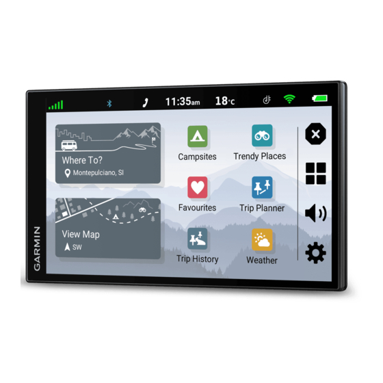
(Hands-free calling, page 27). Current time. Select to set the time (Setting the Time, page 39). Battery charge level. Garmin Drive app connection status (Pairing with Your Smartphone, page 24). ™ Temperature. Select to view the weather forecast (Viewing the weather forecast, page 31). -
Page 10: Enabling Automatic Volume
CAUTION The driver alerts and speed limit features are for information only. They do not replace your responsibility to abide by all posted speed limit signs and to use safe driving judgement at all times. Garmin is not responsible ®... -
Page 11: Red Light And Speed Cameras
Red light and speed cameras NOTICE Garmin is not responsible for the accuracy of or the consequences of using a red light or speed camera database. NOTE: this feature is not available for all regions or product models. Information about red light and speed camera locations is available in some areas for some product models. -
Page 12: Finding An Address
Finding an address NOTE: the order of the steps may change depending on the map data loaded on your device. 1 Select Where To?. 2 If necessary, select to search near a different town or area. 3 Select Address. 4 Follow the on-screen instructions to enter address information. 5 Select the address. -
Page 13: Changing The Search Area
Changing the search area By default, the device searches for locations near your current location. You can also search other areas, such as near your destination, near another city, or along your active route. 1 Select Where To?. 2 Select next to the current search area 3 Select a search area. -
Page 14: Finding Acsi™ Campsites
Finding Campsites with Amenities You can search for motorhome parks and campsites based on the amenities available. 1 Select Where To?. 2 Select an motorhome parks and campgrounds search provider, such as ACSI, Campercontact or iOverlander. 3 If necessary, select a category. 4 Select Search Filters, select one or more amenities and select Save. -
Page 15: Michelin
Michelin ® Your device includes Michelin points of interest and ratings. Michelin ratings appear automatically in the search results list for applicable points of interest. You can also search for nearby Michelin points of interest and sort by distance or popularity. Finding Michelin points of interest 1 Select Where To? >... -
Page 16: Finding A Junction
4 Select Go!. Parking Your CamperVan device includes detailed parking data, which can help you find nearby parking based on the likelihood of available parking spots, type of parking area, price, or accepted payment methods. NOTE: detailed parking data is not available in all areas or for all parking locations. -
Page 17: Clearing The List Of Recently Found Places
Clearing the list of recently found places Select Where To? > History > > Clear > Yes. Viewing current location information You can use the Where Am I? page to view information about your current location. This feature is helpful if you need to tell emergency personnel your location. -
Page 18: Saving Your Current Location
Saving your current location 1 From the map, select the vehicle icon. 2 Select Save. 3 Enter a name and select Done. Editing a favourite location 1 Select Where To? > Favourites. 2 If necessary, select a category. 3 Select a location. 4 Select 5 Select >... -
Page 19: Navigating To Your Destination
Navigating to your destination Routes A route is a path from your current location to one or more destinations. • The device calculates a recommended route to your destination based on the preferences you set, including the route calculation mode (Changing the route calculation mode, page 17) and avoidances (Avoiding... -
Page 20: Starting A Route By Using The Map
Starting a route by using the map You can start a route by selecting a location from the map. 1 Select View Map. 2 Drag and zoom the map to display the area to search. 3 If necessary, select to filter the displayed points of interest by category. Location markers ( or a blue dot) appear on the map. -
Page 21: Your Route On The Map
Your route on the map As you travel, the device guides you to your destination using voice prompts and information on the map. Instructions for your next turn or exit, or other actions appear across the top of the map. Next action in the route. -
Page 22: Viewing Turns And Directions
Viewing turns and directions While navigating a route, you can view upcoming turns, lane changes, or other directions for your route. 1 From the map, select an option: • To view upcoming turns and directions as you navigate, select > Turns. The map tool displays the next several turns or directions beside the map. -
Page 23: Changing Your Active Route
Changing Your Active Route Adding a location to your route Before you can add a location to your route, you must be navigating a route (Starting a route, page 13). You can add locations to the middle or end of your route. For example, you can add a petrol station as the next destination in your route. -
Page 24: Using Suggested Routes
Using Suggested Routes Before you can use this feature, you must save at least one location and enable the travel history feature (Device and privacy settings, page 39). Using the myTrends feature, your device predicts your destination based on your travel history, the day of the ™... -
Page 25: Custom Avoidances
Custom Avoidances Custom avoidances allow you to select specific areas or sections of road to avoid. When the device calculates a route, it avoids these areas and roads unless no other reasonable route is available. Avoiding a road 1 Select >... -
Page 26: Using The Map
Report Safety Camera: allows you to report a speed or red light camera. This tool is available only when you have speed or red light camera data on your device and you have an active connection to the Garmin Drive (Live services, traffic and smartphone features, page 23). -
Page 27: Viewing Upcoming Locations
Viewing upcoming locations 1 From the map, select > Up Ahead. While you are travelling, the map tool shows the next location along your road or route. 2 Select an option: • If the map tool shows categories, select a category to view a list of nearby locations in that category. •... -
Page 28: Viewing The Trip Information Page
• Select Reset Trip B to reset the odometer. Viewing upcoming traffic NOTICE Garmin is not responsible for the accuracy or timeliness of the traffic information. Before you can use this feature, your device must be receiving traffic data (Traffic, page 28). -
Page 29: Viewing Traffic On The Map
• Select 3-D to display the map in three dimensions. Live services, traffic and smartphone features The Garmin Drive app allows your device to receive smart notifications and live information, such as live traffic data and weather information. Live traffic data: sends real-time traffic data to your device, such as traffic incidents and delays, construction... -
Page 30: Pairing With Your Smartphone
1 From the app store on your smartphone, install the Garmin Drive app. 2 Turn on your CamperVan device and place the device and your smartphone within 3 m (10 ft.) of each other. 3 On your phone, open the Garmin Drive app. -
Page 31: Bluetooth Feature Status Icons
Do not read or reply to notifications while driving. If you do so, you could become distracted by the display, which could lead to an accident causing serious personal injury or death. Before you can use this feature, your device must be connected to a supported phone running the Garmin Drive (Live services, traffic and smartphone features, page 23). -
Page 32: Viewing The List Of Notifications
Going to an address or location using the Garmin Drive app You can use the Garmin Drive app to search for an address, business or point of interest and send it to your CamperVan device for navigation. 1 From the Garmin Drive app, select Where To?. -
Page 33: Hands-Free Calling
Hands-free calling NOTE: while most phones are supported and can be used, it cannot be guaranteed that a particular phone can be used. All features may not be available for your phone. Using Bluetooth wireless technology, your device can connect to your mobile phone to become a hands-free device (Live services, traffic and smartphone features, page 23). -
Page 34: Saving A Home Phone Number
Traffic data is not available in all areas. For information about traffic coverage areas, go to garmin.com/traffic. Receiving traffic data using your smartphone Your device can receive subscription-free traffic data while connected to a smartphone running the Garmin Drive app. -
Page 35: Receiving Traffic Data Using A Traffic Receiver
Traffic data is not available in all areas. For information about traffic coverage areas, go to garmin.com/traffic. Connect the device to vehicle power using the traffic-compatible power cable (Mounting and powering the... -
Page 36: Searching For Traffic Incidents
Launching Garmin Voice-Activated Navigation Garmin voice-activated navigation allows you to use requests spoken in plain language to search for locations and addresses, start routes with turn-by-turn directions, place hands-free phone calls and more. -
Page 37: Using The Apps
• To add a favourite town, select Add Town, and enter a town name. Viewing the weather radar Before you can use this feature, your device must be connected to a supported phone running the Garmin Drive (Live services, traffic and smartphone features, page 23). -
Page 38: Birdseye Imagery
BirdsEye Imagery BirdsEye imagery provides downloadable, high-resolution map imagery, including detailed satellite imagery and raster-based topographical maps. You can download BirdsEye Satellite Imagery directly to your device when it is connected to a Wi‑Fi network. ® Downloading BirdsEye Imagery Before you can download BirdsEye imagery directly to your device, you must connect to a wireless network (Connecting to a Wi‑Fi Network, page 41). -
Page 39: Editing And Reordering Locations In A Route
Editing and Reordering Locations in a Route 1 Select Route Planner. 2 Select a saved route. 3 Select List. 4 Select a location. 5 Select an option: • To move the location up or down, select and drag the location to a new position in the route. •... -
Page 40: Tracback
2 Select > Save as Route. 3 Enter a name and select Done. photoLive traffic cameras Before you can use this feature, your device must be connected to the Garmin Drive app (Live services, traffic and smartphone features, page 23). -
Page 41: Wireless Cameras
The camera remains in pairing mode for two minutes. If pairing mode expires, you can remove and reinstall the batteries. 3 Bring the compatible Garmin navigation device outside your vehicle and within 1.5 m (5 ft.) of the camera and turn on the navigation device. -
Page 42: Viewing Previous Routes And Destinations
This allows you to use the parking stall lines at the rear of the vehicle as reference points for alignment. 2 From the paired Garmin navigation device, select > Wireless Cameras. 3 Select the paired camera name and select Guidance Lines > Adjust Guidance Lines. -
Page 43: Settings
Enabling maps You can enable map products installed on your device. TIP: to purchase additional map products, go to garmin.com/maps. 1 Select > Map Display > myMaps. 2 Select a map. -
Page 44: Wireless Network Settings
Wireless network settings The wireless network settings allow you to manage Wi‑Fi networks, paired Bluetooth devices and Bluetooth features. Select > Wireless Networks. Bluetooth: enables Bluetooth wireless technology. Paired Device Name: the names of paired Bluetooth devices appear in the menu. You can select a device name to change Bluetooth feature settings for that device. -
Page 45: Units And Time Settings
Units and time settings To open the Units and Time settings page, from the main menu, select > Units & Time. Current Time: sets the device time. Time Format: allows you to select a 12-hour, 24-hour or UTC display time. Units: sets the unit of measure used for distances. -
Page 46: Device Information
• Connect the device to an optional power adapter accessory, such as a wall power adapter. You can purchase an approved Garmin AC-DC adapter suitable for home or office use from a Garmin dealer or www.garmin.com. The device may charge slowly when connected to a third-party adapter. -
Page 47: Connecting To A Wi-Fi Network
TIP: if a map update is interrupted or cancelled before it completes, your device may be missing map data. To repair missing map data, you must update the maps again using either Wi‑Fi or Garmin Express. Device maintenance... -
Page 48: Updating Maps And Software With Garmin Express
Updating Maps and Software with Garmin Express You can use the Garmin Express application to download and install the latest map and software updates for your device. 1 If you do not have the Garmin Express application installed on your computer, go to garmin.com/express... -
Page 49: Device Care
1 On your computer, go to garmin.com/express. 2 Select an option: • To view the system requirements and verify the Garmin Express application is compatible with your computer, select System Requirements. • To install on a Windows computer, select Download for Windows. -
Page 50: Removing The Device From The Mount
1 Clean the suction cup and windscreen with surgical spirit. 2 Dry with a clean, dry cloth. 3 Mount the suction cup (Mounting and powering the CamperVan device in your vehicle, page My device is not acquiring satellite signals • Verify the GPS simulator is turned off (Navigation settings, page 37). -
Page 51: My Device Does Not Connect To My Phone
Garmin mapping software. The device supports microSD memory cards from 4 to 32 GB. 1 Locate the map and data memory card slot on your device (CamperVan device overview, page 2 Insert a memory card into the slot. -
Page 52: Disconnecting The Usb Cable
2 Disconnect the cable from your computer. Viewing GPS signal status Hold for three seconds. Purchasing additional maps 1 Go to your device product page at garmin.com. 2 Click the Maps tab. 3 Follow the on-screen instructions. Purchasing accessories • Optional accessories are available at garmin.com... -
Page 53: Index
15, 16, 30 audio, proximity points 38 junctions 10 off-road 19 automatic volume, enabling 4 towns 21 settings 37 avoidances 18 fuel, stations 11 next turn 15 area 19 notifications 24–26 deleting 19 disabling 19 Garmin Connect 23 road 19 Garmin Express 43 off-road navigation 19 road features 18 updating software 42 on-screen buttons 3 tolls 18 going home 14 owner's manual 31 GPS 3, 46... - Page 54 screenshots 38 search bar 5 settings 37–39 shaping a route 17 shortcuts adding 11 deleting 11 simulated locations 37 sleep mode 2 smartphone features 24, 25 connecting 24 disabling calls 24 software updating 40–42 version 39, 43 speaking commands 30 specifications 40 speech recognition 30 speed cameras 5 suction cup 44 theft, avoiding 43 time settings 39 tolls, avoiding 18 tools, maps 20 TracBack 34 traffic 22, 28, 29, 38...
- Page 56 June 2021 GUID-1FBAE37F-A16E-441B-9E2D-F98F57D6EA68 v2...
Need help?
Do you have a question about the CamperVan and is the answer not in the manual?
Questions and answers