
Subscribe to Our Youtube Channel
Related Manuals for Onwa KP-622


Summary of Contents for Onwa KP-622
- Page 1 KP-622/623/823 KP-622/623/823 Ë µ Ã ÷ Ê é Ë µ Ã ÷ Ê é OPERATOR`S MANUAL 3 Series GPS Chart Plotter...
-
Page 3: P Roduct Introduce
roduct Introduction... -
Page 4: Table Of Contents
CONTENTS roduct introduce Foreword 1. Keypad instruction 2. Basic Operation 2.1 Display Plotter screen Navigation screen Route screen Positioning screen 2.2 Operation Turning the power on/off, adjusting the brightness and contrast Waypoint establishment and ship's position storage Delete waypoints Single point navigation and cancel navigation Route setting and route navigation Track record Emergency (MOB) navigation... - Page 5 Alarm Tide Unit Setup In/Out 4. AIS function of 3 Series Start AIS function Vessels list The collision alarm Own ships info rmation Chart Screen View AIS vessels' information on chart screen Check all AIS ships within the scope of Radar Emergency alarm Entry/Departure setting Navigation Terms...
-
Page 6: Foreword
FOREWORD FOREWORD The ONWA 3 seriesof ONWA GPS navigation aid are specially designed for the vessel traffic management, ONWA is a professional brand of the domestic and for- eign navigation products. The products are designed to be all-sealed and waterproof, can be rapid position- fixing and resistant to poor environment. -
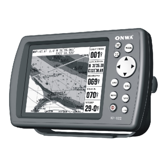
Page 7: Keypad Instruction
1. Keypad instruction Keypad instruction Keypad instruction ( Figure 1-1) MENU: Pressing it displays the menu of the current page, pressing twice enters the main-menu. : Enlarges the scale of the maps and charts,16 grades totally. Display the listed items of the page by revers e-scrolling. : Reduces the scale of the maps and charts,16 grades totally. -
Page 8: Basic Operation
2. BASIC OPERATION BASIC OPERATION 2.1 Main Screens The five main screens are as following: Plotter screen, Navigation screen (see Figure 2), Route screen, AIS Radar View and Position screen(see Figure 3). Keep pressing arrow key displays accordingly the four main screens by a posit- ive cycle, keep pressing exit key displays them by a reverse cycle Power on Navigation... -
Page 9: Plotter Screen
(1) Plotter screen : Pressing MENU key displays the following menu, Figure 4), press [ENT] to enter sub-menu(see Figure 5). Measure Distance ¯¯Measure the distance from own ship to the target. Set Up Map ¯¯Hide or display the waypoint name, the direction, the route, the place name, grid lines, fishing lines, the first flight line, the dynamic track, history of the track, the name of obstacles, water depth, etc.. -
Page 10: Navigation Screen
2 Navigation screen Pressing MENU key displays the following menu. Hides the markings of initial course. Hide Bug Indicator Change the items showed in the data field . Same as above. Set Data Fields Press the up/ down Arrow keys to move the cursor to the "hea- Heading up ding up"... -
Page 11: Operation
2.2 Operation 2.2.1. Turning the power on/off, adjusting the brightness and the contrast Power on : Pressing and holding the Power key till it beeps turns the power on, the screen displays pictures. Power off Pressing and holding the Power key till it beeps turns the power off, it displays the countdown screen then disappears after 5 seconds. -
Page 12: Delete Waypoints
Then move the cursor to "OK" column, and press the ENT key to complete the establishment of a new waypoint. See Figure 13 Position storage and the estab- lishment of a new waypoint. Establish a new waypoint by ship's position: After get satellite fix, press... -
Page 13: Single Point Navigation And Cancel Navigation
2.2.4. Single point navigation and cancel navigation Single point navigation Pressing the NAV key at any screen appears the navigation menu. Move the cur- sor to the " Go To Point " column and press ENT key to select the single point navigation.If cursor navigation is required, move the cursor to "cursor navigation"... - Page 14 2 ) Press the MODE key to enter the plotter screen, press the MENU key and move the cursor to the " Edit Route " column, then press the ENT key, the route window pops up, move the cursor to "New Route" column, press the ENT key, appears the new route screen.
-
Page 15: Track Record
route/reverse route navigation Press the MODE key to enter the Route screen, then press MENU key and Invert move the cursor to the "Start Navigation" column (being implemented), or " " column (in reverse order), and then press ENT to begin navigation. See Figure 20 2.2.6. - Page 16 After the beginning of track record, even if it's under the pause state, move the cursor to the "Stop", click ENT key to turn off the record. And will automatically name the track record for the user to edit. At the beginning of track record, the "scale ruler"...
- Page 17 The "Dist" mode for the track record is as following: it takes length as the measure unit for track record interval, and records 1 track point in a specified distance range. The smallest distance interval is 0.01 nm (about 18 m). Choosing a suitable interval value for the track record can make a full use of the track storage space, e.g., if take 0.5 nm (about 900 m) as the record interval, for a track record of 2100 track points, it can record at least nm miles of the routes;...
- Page 18 Track display on/off Double-click the MENU key to enter the main menu, move the cursor to the "Track" column, and then press the right Arrow key to move the cursor to the track need to be edited, press MENU key, Move the cursor to the " Open Display "...
-
Page 19: Emergency (Mob) Navigation
The other way to enter track back navigation is as following: Click the NAV key at any screen, move the cursor to " Navigate Track " column and press ENT key, see Figure 24. Press ENT key on the " Navigate Track "... -
Page 20: Main Menu
3.THE MAIN MENU FUNTION 3.THE MAIN MENU FUNTION Pressing the MENU key twice at any of the main screens can enter the main menu, move the cursor to a column, press the right Arrow key to enter that col- umn for setting or adjusting. The satellite distribution is on the left of the upper half screen, the longitude and latitude of the current location, the year, the month, the day and the time on the right. -
Page 21: Barrier
Barriers Enter the " Barrier " column, there is two ways to establish the barrier point. 1) Press the MENU key to select " New Barr ", press ENT key to enter the Barrier window, move the cursor to the "symbol" option beside the "Name"... -
Page 22: Alarm
Alarm Enter the "Alarm" column to review and set the alarm as following: Next WPT point alarm, Arrival alarm, Offset alarm, Anchor Drag alarm, Impact(Collision) alarm, PDOP (accuracy) alarm. See Figure 30 Tide Enter the "Tide" column, move the cursor respectively to "At" column, and press the ENT key, the tides situation of the major ports along the coast on any parti- cular date can be found. -
Page 23: Setup
Setup Enter the "Setup" column to review and set the manner as following : System Mode: Marine or Simulator Data Source: Inside, SD or Auto Speed Filter : (continuously adjustable from 0 to 99 levels): The users may set the filtering levels of the speed according to the needs, suggest that the larger the winds and waves are, the higher the level is. -
Page 24: Ais Function Of 3 Series
4.THE AIS FUNTION 4.THE AIS FUNTION 4.1 Start AIS function Enter the "Main Menu", select the "In/Out" column, at the " Data In/Out " column select "Connect AIS Device ", and then move the cursor to the "OK", press the ENT key to connect AIS equipment. -
Page 25: Own Ships Info Rmation
4.4 Own ship s information Enter the "vessels list", and press the MENU key, and then select the " Own Ship Info " to check all the information of own ship, see Figure 37. The own ship's information is also displayed on the upper right of the radar screen, see Figure 42. -
Page 26: View Ais Vessels' Information On Chart Screen
4.6 View AIS vessels' information on chart screen There're two ways to view AIS vessels' information: one is to move the cursor to select AIS vessel on the charts screen, and press the ENT key. See Figure 39 The other is to select the AIS vessel from the AIS vessels list, and press the ENT key. -
Page 27: Emergency Alarm
4.8 Emergency alarm The information of the emergency alarm received is displayed on the bottom right corner. The emergency alarm is always available and can not be deleted, if the em- ergency alarm information is not read, after exiting the alarm menu, the "emergency alarm"... -
Page 28: Navigation Terms
Navigation Terms Bearing(BRG) The compass direction from your current location to a destination. Start BRG The desired course between the active from and to waypoints. Distance (Dist) The distance from current location to a destination. Dist to Destination The distance from current location to a Goto destination, or the final waypoint in a route. -
Page 29: Main Performance And Specification
5.Main Performance and Specifications 5.Main Performance and Specifications 5.1 Performance and characteristics 5.1.1 The GPS function 1) Satellite receiver type: 16 discrete channels receiver, differential signals can be received 2) Positioning accuracy: 10 meters (CEP) the accuracy of 3 meters (CEP) 3) Speed accuracy: 0.1 Knots (RMS) 4) Positioning time: 15 seconds for warm start, 45 seconds for cold start 5) Update rate for positioning data: once per second... -
Page 30: Equipment Parameters
KP-823: 0.8 kgs approx. 4) Display KP-823 8" (162mm 121.5mm) 640 480 dot-matrix, TFT color LCD display KP-622 5.7" (119mm 97mm) 320 240 dot-matrix 8 grades of gray liquid crys- tal display. KP-623 5.7" (119mm 97mm) 640 480 dot-matrix, TFT color LCD display... -
Page 31: Equipment Configuration
5.1.6 Installation: (see Figure 45) Figure 45-a Desktop installation Figure 45-b Panel installation Figure 45-c Ceiling installation... - Page 32 Figure 46 8-core electrical cable connection diagram...
Need help?
Do you have a question about the KP-622 and is the answer not in the manual?
Questions and answers