Lowrance HDS Gen3 Operator's Manual
Hide thumbs
Also See for HDS Gen3:
- Operator's manual (184 pages) ,
- Quick start manual (9 pages) ,
- Quick start manual (9 pages)
Table of Contents
Advertisement
Quick Links
Advertisement
Table of Contents

Related Manuals for Lowrance HDS Gen3


Summary of Contents for Lowrance HDS Gen3
- Page 1 HDS Gen3 Operator Manual ENGLISH lowrance.com...
- Page 3 NMEA 2000 is a registered trademark of the National Marine Electronics Association. ® SiriusXM is a registered trademark of Sirius XM Radio Inc. FUSION-Link Marine Entertainment Standard is a registered trademark of FUSION Electronics Ltd. Preface | HDS Gen3 Operator Manual...
- Page 4 CE under R&TTE directive 1999/5/EC • The requirements of level 2 devices of the Radiocommunications (Electromagnetic Compatibility) standard 2008 The relevant Declaration of conformity is available in the HDS Gen3 section on the following website: lowrance.com. Preface | HDS Gen3 Operator Manual...
- Page 5 Manual version This manual is written for the HDS Gen3 software version 1.0. The manual is continuously updated to match new software releases. The latest available manual version can be downloaded from lowrance.com.
- Page 6 Viewing the manual on the screen The pdf viewer included in the HDS Gen3 makes it possible to read the manuals and other pdf files on the screen. Manuals can be downloaded from lowrance.com. The manuals can be read from an inserted microSD card or copied to the unit’s internal memory.
- Page 7 The software version currently on this unit can be found in the About dialog. The About dialog is available in the System Settings. For more information, refer to "About" on page 142. For upgrading your software, refer to "Software upgrades" on page 150. Preface | HDS Gen3 Operator Manual...
- Page 8 Preface | HDS Gen3 Operator Manual...
-
Page 9: Table Of Contents
Vessel symbol Chart scale Panning the chart Positioning the vessel on the chart panel Displaying information about chart items Using the cursor on the chart panel Creating routes Find objects on chart panels 3D charts Contents | HDS Gen3 Operator Manual... - Page 10 Advanced Sonar options Recording Sonar data Sonar view options Sonar settings 76 StructureScan The StructureScan image Zooming the StructureScan image Using the cursor on the StructureScan panel Viewing StructureScan history Setting up the StructureScan image Contents | HDS Gen3 Operator Manual...
- Page 11 94 Simulator Demo mode Simulator source files Advanced simulator settings 97 Autopilot Safe operation with the autopilot Switching from automatic navigation to standby mode Autopilot interface Autopilot control of the trolling motor 104 Autopilot settings Contents | HDS Gen3 Operator Manual...
- Page 12 127 The Media bar 128 Setting up the audio system 129 Audio controls 129 Device explorer 130 Audio options 130 Audio mixer 130 Auxiliary sources 131 Radio 133 DVD video 134 SiriusXM™ weather 134 Sirius status panel Contents | HDS Gen3 Operator Manual...
- Page 13 146 Acknowledging a message 147 Alarms dialog 149 Maintenance 149 Preventive maintenance 149 Checking the connectors 149 Touchscreen Calibration 149 NMEA 0183 Data logging 150 Software upgrades 150 Backing up your system data 154 Touchscreen operation Contents | HDS Gen3 Operator Manual...
- Page 14 Contents | HDS Gen3 Operator Manual...
-
Page 15: Introduction
Use the cursor keys to select an item, confirm by pressing the Enter key. new position Use the cursor keys to select a new position, and then press the Enter key again to confirm the new position. Introduction | HDS Gen3 Operator Manual... -
Page 16: The Front Panel And Keys
Exit (X) key Press to exit a dialog, to return to previous menu level, and to remove the cursor from the panel. Enter key Press to select or save your settings. Introduction | HDS Gen3 Operator Manual... - Page 17 Find menu. Power key Press once to display the System Controls dialog. Repeat short presses to cycle the backlight brightness. Press and hold to turn the unit ON/OFF. Card reader door microSD Card readers Introduction | HDS Gen3 Operator Manual...
-
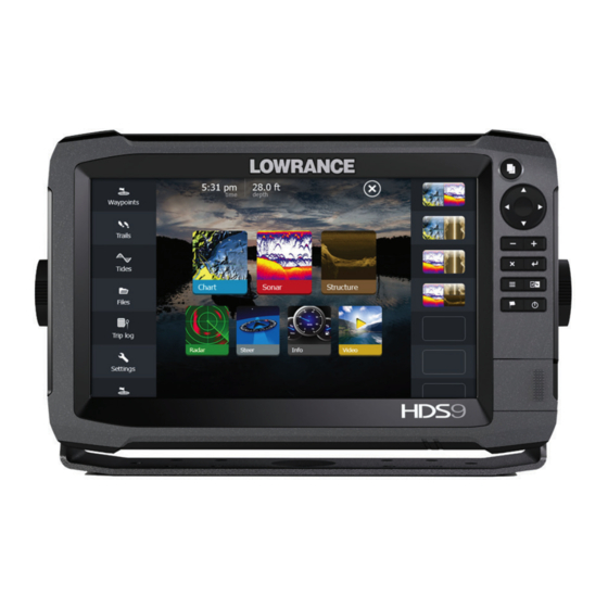
Page 18: The Home Page
Select a button to display the application as a full page panel. Press and hold a button to display pre-configured split page options for the application. Close button Select to exit the Home page and return to the previous active page. Introduction | HDS Gen3 Operator Manual... -
Page 19: Application Pages
Quick access to basic system settings. Display the dialog by a short press on the Power key. Dialog Information to or input from the user. Alarm message Displayed if dangerous situations or system faults occur. Introduction | HDS Gen3 Operator Manual... - Page 20 All preconfigured favorite pages can be modified and deleted, and you can create your own. You can have a total of 12 favorite pages. For more information, refer to "Adding new favorite pages" on page 32. Introduction | HDS Gen3 Operator Manual...
-
Page 21: Integration Of 3 Rd Party Devices
Mercury VesselView integration Mercury VesselView 7 SmartCraft data display and interaction are enabled through the HDS Gen3 when a VesselView 7 or VesselView 4 gateway device is present on the NMEA 2000 network. A Mercury icon appears in the Tools menu when the device is available. - Page 22 For more information, refer to "Info panels" on page 91. GoFree wireless The HDS Gen3 includes built-in wireless functionality that lets you use a wireless device to remotely view (phone and tablet) and control the system (tablet only). The system is controlled from the wireless device by Apps downloaded from their relevant Application store.
-
Page 23: Basic Operation
You turn the system on and off by pressing and holding the Power key. You can also turn the unit off from the System Controls dialog. If the Power key is released before the shut-down is completed, the power off process is cancelled. Basic operation | HDS Gen3 Operator Manual... -
Page 24: Display Illumination
You lock the touchscreen from the System Controls dialog. You remove the lock function by a short press on the Power key. Basic operation | HDS Gen3 Operator Manual... -
Page 25: Using Menus And Dialogs
A dialog is closed by saving or cancelling the entry. A dialog can also be closed by selecting the X in the dialog's upper right corner or by pressing the X key. Basic operation | HDS Gen3 Operator Manual... -
Page 26: Selecting Pages And Panels
The cursor assist function allows for fine tuning and precision placement of the cursor without covering details with your finger. Press and hold your finger on the screen to switch the cursor symbol to a selection circle, appearing above your finger. Basic operation | HDS Gen3 Operator Manual... - Page 27 The grey icon follows the vessel as the vessel moves, while the blue icon remains at the position given when you activated the function. You terminate the measuring function by selecting the Finish measuring menu option. Basic operation | HDS Gen3 Operator Manual...
-
Page 28: Creating A Man Overboard Waypoint
The system continues to display navigational information towards the MOB waypoint until you cancel the navigation from the menu. Display MOB waypoint information You can display MOB information by selecting the MOB waypoint and then the MOB waypoint pop-up. Basic operation | HDS Gen3 Operator Manual... -
Page 29: Screen Capture
Simultaneously press and hold the Pages and Power keys to take a screen capture. By default, screen captures are saved to internal memory. Refer to "Tools" on page 140 for how to view files. Basic operation | HDS Gen3 Operator Manual... -
Page 30: Customizing Your System
Select the adjust splits option in the dialog Adjust the panel size by: - Touch operation: dragging the adjustment icon - Key operation: using the cursor keys to move the adjustment icon Customizing your system | HDS Gen3 Operator Manual... -
Page 31: Data Overlay
Change a selected data overlay to display different data. • Configure a selected data overlay appearance (digital or analog, size, and so on). • Re-locate an item by selecting and moving it. Customizing your system | HDS Gen3 Operator Manual... -
Page 32: Adding New Favorite Pages
- Select the X icon to remove the page - Select the tool icon to display the page editor dialog Add or remove panels in the page editor dialog. Save or discard your changes to leave the favorite edit mode. Customizing your system | HDS Gen3 Operator Manual... -
Page 33: Charts
AIS targets. You can overlay a radar image, a StructureScan image or weather information. The Chart panel Description Waypoint* Vessel with Heading extension line (Heading extension line is optional) Route* North indicator Grid lines* Range rings* Trail* Charts | HDS Gen3 Operator Manual... -
Page 34: Chart Data
For a full selection of available charts please visit insightstore.navico.com, c-map.jeppesen.com or navionics.com. Note: Ú Insight charts are referred to as Lowrance in the menu. Charts on microSD cards are shared over the Ethernet network, so only one chart card per vessel is required. -
Page 35: Vessel Symbol
Select the Clear cursor menu option or press the X key to remove the cursor and cursor window from the panel. This also centers the chart to the vessel position. Charts | HDS Gen3 Operator Manual... -
Page 36: Positioning The Vessel On The Chart Panel
You can also activate the detailed information dialog from the menu. Note: Ú Pop-up information has to be enabled in chart settings to see basic item information. Charts | HDS Gen3 Operator Manual... -
Page 37: Using The Cursor On The Chart Panel
You can search for other vessels or various chart items from a chart panel. Activate the cursor on the panel to search from the cursor position. If the cursor is not active, the system searches for items from the vessel's position. Charts | HDS Gen3 Operator Manual... -
Page 38: 3D Charts
When centered on the vessel position, only the tilt angle can be adjusted. The view direction is controlled by the chart orientation setting. See "Positioning the vessel on the chart panel" on page 36. Charts | HDS Gen3 Operator Manual... -
Page 39: Chart Overlay
Orientation, Look ahead, 3D and Change to Navionics/ Change to Insight (previously described in this section) are common for all chart types. Chart imagery style The charts can be displayed in three imagery styles. 2D mapping style Shaded relief No contours Charts | HDS Gen3 Operator Manual... -
Page 40: Insight View Options
Land Exaggeration and Water Exaggeration Graphical settings available in 3D mode only. Exaggeration is a multiplier applied to the drawn height of hills on land, and troughs in water to make them look taller or deeper. Charts | HDS Gen3 Operator Manual... -
Page 41: Navionics Specific Chart Options
Toggles on the chart layer including Navionics edits. These are user information or edits uploaded to Navionics Community by users, and made available in Navionics charts. For more information, refer to Navionics information included with your chart, or to Navionics website: www.navionics.com. Charts | HDS Gen3 Operator Manual... -
Page 42: Navionics Chart Settings
Rock filter level Hides rock identification on the chart beneath a given depth. This helps you to declutter charts in areas where there are many rocks located at depths well below your vessel's draught. Charts | HDS Gen3 Operator Manual... -
Page 43: Navionics View Options
The gauge has 8 labels and is set according to absolute max/min value of the evaluated day. The red arrow is used when tide is rising, and the blue arrow is used when tide is falling. Charts | HDS Gen3 Operator Manual... -
Page 44: Easy View
Photo overlay, land only Full Photo overlay Photo transparency The Photo transparency sets the opaqueness of the photo overlay. With minimum transparency settings the chart details are almost hidden by the photo. Minimum transparency Maximum transparency Charts | HDS Gen3 Operator Manual... - Page 45 Highlights areas of shallow water. This allows you to highlight areas of water between 0 and the selected depth (up to 10 meters/30 feet). No shallow water highlighted Shallow water highlight: 0 m - 3 m Charts | HDS Gen3 Operator Manual...
-
Page 46: Jeppesen Tides And Currents
(equal to or less than 1 knot), depending on the current in that location. If there is no current (0 knots) this will be shown as a white, square icon. Static Current and Tide icons Dynamic Current icons Charts | HDS Gen3 Operator Manual... -
Page 47: Chart Settings
U.S. territorial waters. Range Rings The range rings can be used to present the distance from your vessel to other chart objects. The range scale is set automatically by the system to suit the chart scale. Charts | HDS Gen3 Operator Manual... - Page 48 Turns on/off viewing of longitude and latitude grid lines on the chart. Hide chart If the option is set to ON when viewing a Lowrance chart, the chart (background) is not displayed and only the vessel, extensions, waypoints, and routes are displayed on a white background.
-
Page 49: Waypoints, Routes, And Trails
Sonar image. Each waypoint has an exact position with latitude and longitude coordinates. A waypoint positioned from the Sonar image has a depth value, in addition to position information. Waypoints, Routes, and Trails | HDS Gen3 Operator Manual... -
Page 50: Saving Waypoints
Activate the menu and select the waypoint in the menu Select the move option Select the new waypoint position Press the Enter key to confirm the new position. The waypoint is now automatically saved at the new position. Waypoints, Routes, and Trails | HDS Gen3 Operator Manual... -
Page 51: Routes
Position the first waypoint on the chart panel. Continue positioning new routepoints on the chart panel until the route is completed. Save the route by selecting the save option in the menu. Waypoints, Routes, and Trails | HDS Gen3 Operator Manual... - Page 52 Creating routes using existing waypoints You can create a new route by combining existing waypoints from the Routes dialog. The dialog is activated by using the Routes tool on the Home page. Waypoints, Routes, and Trails | HDS Gen3 Operator Manual...
-
Page 53: Converting Trails To Routes
Note: Ú HDS Gen3 units designed for sale in the U.S. region do not have Autorouting or Easy Routing capabilities. Autorouting or Easy Routing features are disabled on all non-U.S. units when they are used in U.S. territorial waters. - Page 54 Select Save to complete the automatic routing and save the route. Autorouting and Easy Routing examples Entire route option used when first and last route points are • selected. First and last routepoint Result after automatic routing Waypoints, Routes, and Trails | HDS Gen3 Operator Manual...
- Page 55 You can add and remove routepoints from the Edit Route dialog. This dialog is activated by selecting an active route's pop-up or from the menu. The dialog can also be accessed by using the Routes tool on the Home page. Waypoints, Routes, and Trails | HDS Gen3 Operator Manual...
-
Page 56: Trails
Note: Ú The Trails option must also be turned ON in the chart settings to be visible. Waypoints, Routes, and Trails | HDS Gen3 Operator Manual... - Page 57 Waypoints, Routes, and Trails | HDS Gen3 Operator Manual...
-
Page 58: Navigating
The Steer panel can be used to display information when you are navigating. It is activated from the Home page, either as a full page panel or as part of a multiple panel page. Description Data fields Vessel heading Bearing to waypoint Destination point Navigating | HDS Gen3 Operator Manual... -
Page 59: Navigate To Cursor Position
Position the cursor at the selected destination on the panel, and then select the Goto Cursor option in the menu. Navigate a route You can start navigating a route from the chart panel, steer panel, or from the Route dialog. Navigating | HDS Gen3 Operator Manual... - Page 60 You can start navigating from the Route dialog, activated by: Selecting the Route tool from the Home page • • Selecting the route details from the menu Cancel navigation When you are navigating, the menu includes an option for cancelling the navigation. Navigating | HDS Gen3 Operator Manual...
-
Page 61: Navigating With The Autopilot
This setting defines how far the vessel can deviate from the selected route, if the vessel goes beyond this limit, an alarm is activated. XTE alarm (Cross track error) Turns on/off the XTE alarm. Navigating | HDS Gen3 Operator Manual... - Page 62 Defines Loran chains (GRI) and preferred station for waypoint entry, cursor position and position panel. The graphic example shows a cursor position window with Loran position information. For more information refer to your Loran system documentation. Navigating | HDS Gen3 Operator Manual...
-
Page 63: Sonar
The Sonar image Description Fish arches History preview* Temperature graph* Depth at cursor Amplitude scope* Zoom (range) buttons Water depth and Water temperature at cursor location Range scale Bottom * Optional Sonar image items. Sonar | HDS Gen3 Operator Manual... -
Page 64: Zooming The Sonar Image
Whenever the cursor is shown on the Sonar panel, the scroll bar is shown at the top of the panel. The scroll bar shows the image you are currently viewing in relation to the total Sonar image history stored. Sonar | HDS Gen3 Operator Manual... -
Page 65: Setting Up The Sonar Image
By default, the range is set to Auto. With Auto, the system automatically displays the whole range from the water surface to the bottom. Auto is the preferred setting for most fish finding sonar use. Sonar | HDS Gen3 Operator Manual... - Page 66 If the bottom is well beyond the lower range set, you may lose digital depth. Sonar frequency The HDS Gen3 unit supports several transducer frequencies. Available frequencies depend on the transducer model that is connected. You can view two frequencies at the same time by selecting dual Sonar panels from the Home page.
-
Page 67: Stop Sonar
A high scroll speed updates the image fast, while a low scroll speed presents a longer history. Note: Ú In certain conditions it may be necessary to adjust the scroll speed to get a more useful image. Such as Sonar | HDS Gen3 Operator Manual... -
Page 68: Recording Sonar Data
Recording Sonar data You can record Sonar and StructureScan data and save the file internally in the HDS Gen3 unit, or save it onto a microSD card inserted into the unit’s card reader. The Log sonar dialog is activated from the Advanced menu option, or the from the Sonar Settings dialog. - Page 69 If more than one channel was recorded in the selected echo file, you can select which channel to display. You exit the replay mode by pressing the X key or by selecting the X symbol in the upper right corner of the replay image. Sonar | HDS Gen3 Operator Manual...
-
Page 70: Sonar View Options
+/- keys, or the zoom (+ or -) buttons. The range zoom bars on the right side of the display shows the range that is magnified. If you increase the zooming factor the range is reduced. You see this as reduced distance between the zoom bars. Sonar | HDS Gen3 Operator Manual... -
Page 71: Bottom Lock
When toggled on, a colored line and temperature digits are shown on the Sonar image. Depth line A depth line can be added to the bottom surface to make it easier to distinguish the bottom from fish and structures. Sonar | HDS Gen3 Operator Manual... -
Page 72: Amplitude Scope
You can also select if you want to be notified by a beep when a fish ID appears on the panel. Fish symbols and depth Traditional fish echoes Fish symbols indication Note: Ú Not all fish symbols are actual fish. Sonar | HDS Gen3 Operator Manual... -
Page 73: Sonar Settings
Network Sonar You can share the Sonar images from this HDS Gen3 unit with other HDS units connected on the Ethernet network. For more information about how to setup Sonar, refer to the separate HDS Gen3 Installation manual. - Page 74 If more than one channel was recorded in the selected sonar file, you can select which channel to display. You exit the view function by selecting the X in the upper right corner or by pressing the X key. Sonar | HDS Gen3 Operator Manual...
- Page 75 Installation Used for Sonar installation and setup. See the separate HDS Gen3 Installation manual. Sonar | HDS Gen3 Operator Manual...
-
Page 76: Structurescan
The StructureScan image The view The StructureScan panel can be set up as a DownScan image, or showing left/right side scanning. The DownScan image can also be added as an overlay to the traditional Sonar image. StructureScan | HDS Gen3 Operator Manual... -
Page 77: Zooming The Structurescan Image
When you position the cursor on a SideScan image; the screen pauses, and the cursor information window is activated. On a SideScan image, the left/right distance from the vessel to the cursor are shown at the cursor position. StructureScan | HDS Gen3 Operator Manual... -
Page 78: Viewing Structurescan History
Use the StructureScan menu to set up the image. When the cursor is active, some options in the menu are replaced with cursor mode features. Select Clear cursor to return to the normal menu. StructureScan | HDS Gen3 Operator Manual... -
Page 79: Stop Sonar
You can set up the StructureScan page as a DownScan image, left only, right only, or left/right side scanning. Stop sonar Use the Stop sonar menu option when you want to turn off the StructureScan transducer, but not turn off the unit. StructureScan | HDS Gen3 Operator Manual... -
Page 80: Advanced Structurescan Settings
By default, the sonar history preview appears when the cursor is active. Recording StructureScan data You can Log sonar data and save the file internally in the HDS Gen3 unit, or onto a microSD card as described in "Recording sonar data" on page 68. StructureScan | HDS Gen3 Operator Manual... -
Page 81: Spotlightscan
The SpotlightScan transducer works with most MotorGuide and Minn Kota cable steer trolling motors. Its scanning speed is controlled by how fast the trolling motor is rotated with the foot pedal. The SpotlightScan image SpotlightScan | HDS Gen3 Operator Manual... -
Page 82: Spotlightscan Setup
Select the Spotlight menu option. You can set up multiple panel pages to view SpotlightScan, broadband sonar, and Downscan images at the same time. You cannot view SpotlightScan and SideScan images at the same time. SpotlightScan | HDS Gen3 Operator Manual... -
Page 83: Spotlightscan Options
455 kHz has the best range, but with lower resolution. Advanced SpotlightScan settings Surface clarity Wave action, boat wakes and temperature inversions can cause onscreen clutter near the surface. The surface clarity option reduces SpotlightScan | HDS Gen3 Operator Manual... - Page 84 The noise rejection option filters the signal interference and reduces on-screen clutter. Log sonar You can Log sonar data and save the file internally in the HDS Gen3 unit, or onto a microSD card as described in "Recording Sonar data" on page 68.
-
Page 85: Spotlightscan Operation Tips
Rotate the trolling motor at a slow, constant speed to achieve the best results. • Reducing the range increases the size of the water column, providing the best view of fish activity beneath the boat. SpotlightScan | HDS Gen3 Operator Manual... -
Page 86: Structuremap
Turn on Structure overlay from the chart menu - The chart menu is increased to show Structure options - Structure data starts to appear on the chart screen as soon as Structure overlay is enabled StructureMap | HDS Gen3 Operator Manual... -
Page 87: Structuremap Sources
When saved files are used as the source, all StructureMap files found on the microSD card and in the system’s internal memory are displayed. If there is more than one StructureMap of the same area, the images StructureMap | HDS Gen3 Operator Manual... -
Page 88: Structuremap Tips
The recording is stopped by re-selecting the record function. Converting StructureScan data to StructureMap format A StructureScan log file (.sl2) is converted to StructureMap format (.smf ) after recording from the recording dialog, or from the files browser. StructureMap | HDS Gen3 Operator Manual... -
Page 89: Using Structuremap With Mapping Cards
When using StructureMap with mapping cards, copy the StructureMap (.smf ) files to the unit’s internal memory. We recommend keeping copies of StructureMap files on external microSD cards. StructureMap | HDS Gen3 Operator Manual... -
Page 90: Structure Options
Clear live Clears existing live history data from the screen history and begins showing only the most current data. Log Sonar data Records StructureScan data. Source Selects StructureMap source. StructureMap | HDS Gen3 Operator Manual... -
Page 91: Info Panels
You can also set limits for analog gauges. All edit options are available from the Info panel menu. Available editing options depends on which data sources are connected to your system. Info panels | HDS Gen3 Operator Manual... - Page 92 Select the gauge you want to change. Selected gauge is indicated with a blue background. Select information to be displayed, configure limits, and eventually change the source for the information. Save your changes by selecting the save option in the menu. Info panels | HDS Gen3 Operator Manual...
-
Page 93: Video
Video source HDS Gen3 supports one video input channel. Video standard HDS Gen3 supports NTSC and PAL video. Check the local video standard or the standard of your cameras. Adjusting the video image You can optimize the video display by adjusting the video image settings. -
Page 94: Simulator
If you tap on a touchscreen or press a key when demo mode is running, the demonstration pauses. After a time-out period, demo mode resumes and any changed settings are restored to default. Note: Ú Demo mode is designed for retail/showroom demonstrations. Simulator | HDS Gen3 Operator Manual... -
Page 95: Simulator Source Files
Selects where the GPS data is generated from. Speed, Course and Route Used for manually entering values when GPS source is set to Simulated course or Simulated route. Otherwise, GPS data including speed and course come from the selected source file. Simulator | HDS Gen3 Operator Manual... - Page 96 Set start position Moves your vessel to the current cursor position. Note: Ú This option is only available when the GPS source is set to Simulated course. Simulator | HDS Gen3 Operator Manual...
-
Page 97: Autopilot
Xi5 trolling motor software You may have to update the software in the MotorGuide Xi5 trolling motor to use it with the Lowrance SmartSteer interface. If an update is necessary, a Trolling motor update dialog appears on your networked HDS unit(s). The update process is initiated through an HDS unit. -
Page 98: Autopilot Interface
The Autopilot Controller can also be set up as a panel in a split panel page by using the Page Editor to make a Favorite page. For information about Favorite pages, refer to "Adding new favorite pages" on page 32. Autopilot | HDS Gen3 Operator Manual... -
Page 99: Autopilot Control Of The Trolling Motor
Anchor mode Waypoint Enables anchor mode when your vessel arrives at a selected waypoint. Cursor Enables anchor mode when your vessel arrives at the cursor position. Here Enables anchor mode at your current location. Autopilot | HDS Gen3 Operator Manual... - Page 100 Select the direction of the turn. Note: Ú Selecting a turn radius smaller than the GPS accuracy may result in incomplete navigation of the turn pattern. U-turn Changes the current set heading to be 180° in the opposite direction. Autopilot | HDS Gen3 Operator Manual...
-
Page 101: Spiral Turn
Steers the vessel in a C-shaped pattern. Spiral turn Steers the vessel in a spiral with a decreasing or increasing radius. Spiral decreasing radius Spiral increasing radius Zigzag turns Steers the vessel in a zigzag pattern. Autopilot | HDS Gen3 Operator Manual... -
Page 102: Square Turn
In Nav. mode you can use the autopilot to steer the boat to cursor position, to a waypoint position, or along a pre-defined route. The position information from the GPS is used to keep the boat on the track line towards the destination point. Autopilot | HDS Gen3 Operator Manual... - Page 103 You can make speed adjustments on the Heading lock and Navigation control dialogs by selecting the Spd up (+) and Spd down (-) buttons, or by selecting the Set Spd or Set prop option and entering your desired speed or propeller rate. Autopilot | HDS Gen3 Operator Manual...
-
Page 104: Autopilot Settings
The autopilot switches from navigation mode to the selected arrival mode when your vessel reaches the destination. Note: Ú Before starting a navigation mode or a turn pattern, it is important to select an arrival mode that fits your navigation needs. Autopilot | HDS Gen3 Operator Manual... -
Page 105: Anchor Point Setup
Anchor points can be saved as a new waypoint, replaced with an existing waypoint, or set as your current coordinates. Anchor points are synced with the Xi5 trolling motor. If any anchor points are stored in the motor, they appear in the anchor points list. Autopilot | HDS Gen3 Operator Manual... -
Page 106: Radar
For more information, see "Chart overlay" on page 39. Note: Ú Radar overlay requires data from the heading sensor. The Radar panel Description Orientation Range Heading line* Cursor Compass* Cursor position window Range rings* Range markers* Radar | HDS Gen3 Operator Manual... -
Page 107: Radar Overlay
When the radar overlay is selected, basic radar operational functions are available from the Chart panel’s menu. Radar operational modes The radar’s operational modes are controlled from the HDS Gen3 unit. The following modes are available: The power to the radar scanner is turned off. -
Page 108: Adjusting The Radar Image
Rain clutter is used to reduce the effect of rain, snow or other weather conditions on the radar image. The value should not be increased too much as this may filter out real targets. Radar | HDS Gen3 Operator Manual... -
Page 109: Advanced Radar Options
The STC (Sensitivity Time Control) controls the sensitivity of the radar signal close to your vessel. It compensates for distance to the radar object, making returns from equal sized objects appear with the same size on the radar image. Radar | HDS Gen3 Operator Manual... -
Page 110: Radar View Options
Rotates the radar image to display the current heading directly up on the radar image. North up Rotates the radar image with the north direction upwards. Course up Rotates the radar image to display the current navigation course directly up. Radar | HDS Gen3 Operator Manual... - Page 111 Allows you to move the PPI center to any location on the radar panel. Select the offset option from the menu Move the cursor to where you want to position the radar center Confirm the setting by selecting the save offset option in the menu. Radar | HDS Gen3 Operator Manual...
-
Page 112: Ebl/Vrm Markers
Select the save option in the menu to save your settings Placing EBL/VRM markers by using the cursor Position the cursor on the radar image Radar | HDS Gen3 Operator Manual... -
Page 113: Setting A Guard Zone Around Your Vessel
Alarm settings An alarm is activated when a radar target breaches the guard zone limits. You can select if the alarm is activated when the target enters or exits the zone. Radar | HDS Gen3 Operator Manual... -
Page 114: Marpa Targets
Selected MARPA target, activated by positioning the cursor on the target icon. The target returns to the default target symbol when the cursor is removed. Radar | HDS Gen3 Operator Manual... - Page 115 Target details in the menu. MARPA alarm settings You can define the following MARPA alarms: Alarm ID Description MARPA target Controls whether an alarm is activated when a lost MARPA target is lost Radar | HDS Gen3 Operator Manual...
-
Page 116: Recording Radar Data
Gen3 unit, or save it onto a microSD card inserted into the unit’s card reader. A recorded radar file can be used for documenting an event or an operational error. A logged radar file can also be used by the simulator. Radar settings Radar | HDS Gen3 Operator Manual... - Page 117 125. An alarm triggers if a vessel is tracking into your safe zone. Installation The Installation option is used for radar installation, described in the separate HDS Gen3 Installation manual. Radar | HDS Gen3 Operator Manual...
-
Page 118: Ais
Moving and safe AIS target with course extension line. Dangerous AIS target, illustrated with bold line. A target is defined as dangerous based on the CPA and TCPA settings. Refer to "Defining dangerous vessels" on page 125. | HDS Gen3 Operator Manual... -
Page 119: Searching For Ais Items
When you select an AIS icon on the chart or radar panel the symbol changes to Selected target symbol, and the vessel's name is displayed. You can display detailed information for a target by selecting the AIS pop-up, or from the menu when the target is selected. | HDS Gen3 Operator Manual... -
Page 120: Ais Information On Radar Panels
If the system includes a VHF radio supporting DSC (Digital Select Calling) calls over NMEA 2000, you can initiate a DSC call to other vessels from the HDS Gen3. The call option is available in the AIS Vessel Details dialog, and in the Vessel status dialog activated from the Tools panel. -
Page 121: Ais Sart
- The alarm is muted and the message closed. The alarm does not reappear Save the waypoint - The waypoint is saved to your waypoint list. This waypoint name is prefixed with MOB AIS SART - followed by the unique | HDS Gen3 Operator Manual... - Page 122 AIS SART remains in the Vessels list. Note: Ú If the AIS stops receiving the AIS SART message, the AIS SART remains in the Vessels list for 10 minutes after it receives the last signal. | HDS Gen3 Operator Manual...
-
Page 123: Vessel Alarms
The CPA and TCPA define when a vessel is dangerous regardless of the enabled/disabled state. Vessel Controls whether an alarm will be activated message when a message is received from an AIS target | HDS Gen3 Operator Manual... -
Page 124: Vessel Settings
It is also important to have the MMSI number entered to avoid seeing your own vessel as an AIS target on the chart. Note: Ú The Vessel message option in the alarm settings must be toggled on for any MMSI message to be displayed. | HDS Gen3 Operator Manual... -
Page 125: Icon Filters
You can define an invisible guard zone around your vessel. When a target comes within this distance, the symbol changes to the “dangerous” target symbol. An alarm is triggered if activated in the Alarm settings panel. | HDS Gen3 Operator Manual... -
Page 126: Audio
Audio If a SonicHub server or a FUSION marine entertainment system is connected to the NMEA 2000 network, you can use the HDS Gen3 to control and customize the audio system on your vessel. When connected to a WM-3 Satellite module with an active subscription, you can include SiriusXM products on your system. -
Page 127: The Media Bar
Select the Media bar to replace the application menus with Audio menus. Description Media bar Audio source Track, file, or station information Repeat - shown only when repeat is on Shuffle - shown only when shuffle is on Audio | HDS Gen3 Operator Manual... -
Page 128: Setting Up The Audio System
The Mic source selects a high voltage level input allowing you to broadcast loud hailer messages over the audio system. Volume Master volume control By default the volume for all speaker zones are adjusted when you adjust the master volume. Audio | HDS Gen3 Operator Manual... -
Page 129: Audio Controls
You can use the device menu or Device explorer menu options to access the source’s native menu or file structure, which can be used to select tracks. An example of an USB Device explorer: Audio | HDS Gen3 Operator Manual... -
Page 130: Audio Options
AUX and AUX 2 (labeled AUX and SAT IN on the SonicHub) can be used for Sirius radio and external audio devices that support RCA connectivity. Sirius radio playback can be controlled when a Audio | HDS Gen3 Operator Manual... -
Page 131: Radio
Lowrance weather module is connected to SAT IN. Other auxiliary audio sources only have volume control. Detaching Sirius from the AUX source If a Sirius radio is connected to the FUSION radio/server, the AUX source is automatically attached to the Sirius feed. Sirius then appears in the source list when the FUSION server is active. -
Page 132: Radio Favorites
You cannot add unsubscribed channels. Locking channels You can lock selected Sirius channels from being broadcasted. A 4- digit-code must be entered to lock channels and the same code entered to unlock the channels. Audio | HDS Gen3 Operator Manual... -
Page 133: Dvd Video
Open the Home page and select the Video page. Activate the Audio panel and select DVD as the source on the menu. Select the Control menu option. Use the menu options to control the playback. Audio | HDS Gen3 Operator Manual... -
Page 134: Siriusxm™ Weather
Sirius status panel. The status panel shows signal strength is indicated as 1/3 (weak), 2/3 (good) or 3/3 (preferred). It also includes antenna status, service level, and the electronic serial number for the weather module. SiriusXM™ | HDS Gen3 Operator Manual... -
Page 135: Sirius Weather Display
Wind barbs The rotation of the wind barbs indicate the relative wind direction, with the tail showing the direction the wind is coming from. In the graphics below, the wind comes from the northwest. SiriusXM™ | HDS Gen3 Operator Manual... - Page 136 If pop-up is enabled, you can select a weather icon to display the identity of the observation. If you select the pop-up, detailed information about the observation is displayed. You can also display the detailed information from the menu when the weather icon is selected. SiriusXM™ | HDS Gen3 Operator Manual...
-
Page 137: Sirius View Options
Refer to "Adjusting color codes" on page 139. Weather icons Several weather icons are available to show current or predicted weather conditions. You can select an icon to display detailed weather information. Icon Description City forecast SiriusXM™ | HDS Gen3 Operator Manual... -
Page 138: Marine Zones
Select the selected zone, and use the menu to confirm your selection. Tropical statements You can read tropical statements including information about tropical weather conditions. These statements are available for the entire Atlantic and the Eastern Pacific. SiriusXM™ | HDS Gen3 Operator Manual... -
Page 139: Adjusting Color Codes
Waves lower than the minimum value are not color coded. Animating Sirius weather graphics The HDS Gen3 records the weather information you have turned on, and this information can be used to animate past or future weather conditions. The amount of information available in the system depends on the amount of weather activity;... -
Page 140: Tools
By default, the Tools panel includes icons used for accessing options and tools that are not specific to any panel. When external equipment is integrated to the HDS Gen3, new icons might be added to the Tools panel. These icons are used for accessing the external equipment's features. - Page 141 Status page for active satellites. WAAS (and EGNOS) differential position correction can be configured to ON or OFF. Restore defaults Allows you to select which settings are to be restored to their original factory settings. Tools | HDS Gen3 Operator Manual...
- Page 142 Provides a dialog showing total fuel used, fuel used per trip, and fuel used per season. In addition, it provides access to configuration engine and tanks, and calibration of tanks (refuel) dialogs. Refer to the Installation Manual. Tools | HDS Gen3 Operator Manual...
-
Page 143: Vessels
"Simulator" on page 94. Vessels Status listing List of all AIS, MARPA, and DSC vessels with available information. Message listing List of all messages received from other AIS vessels with time stamp. Tools | HDS Gen3 Operator Manual... -
Page 144: Sun/Moon
Exporting files is covered in the section "Maintenance" on page 149. Find Search function for items by categories: waypoints, routes, trails, fuel prices, chart items, vessel's AIS status and vessel's messages, and coordinates. Tools | HDS Gen3 Operator Manual... -
Page 145: Alarms
Color Importance Critical Orange Important Yellow Standard Blue Warning Green Light warning Single alarms A single alarm is displayed with the name of the alarm as the title, and with details for the alarm. Alarms | HDS Gen3 Operator Manual... -
Page 146: Multiple Alarms
Alarms dialog. There is no time-out on the alarm message or siren. They remain until you acknowledge the alarm or until the reason for the alarm is removed. Alarms | HDS Gen3 Operator Manual... -
Page 147: Alarms Dialog
Alarms dialog All alarms are setup in the Alarms Settings dialog. The alarm dialogs can also be activated from the Tools panel. The alarm dialogs include information about active alarms and alarm history. Alarms | HDS Gen3 Operator Manual... - Page 148 Alarms | HDS Gen3 Operator Manual...
-
Page 149: Maintenance
Maintenance Preventive maintenance The HDS Gen3 does not contain any field serviceable components, therefore the operator is required to perform only a very limited amount of preventative maintenance. Checking the connectors The connectors should be checked by visual inspection only. -
Page 150: Software Upgrades
Once accepted, the log file is written to the chosen location. Software upgrades The latest software for the HDS Gen3 is available for download from our website, lowrance.com. Detailed instructions for how to install the software are included in the upgrade files. - Page 151 User data file version 2 (no Can be used when transferring depth) user data from an HDS system to a legacy Lowrance (LMS, LCX, etc.) GPX (GPS Exchange, no depth) This is the format most used on the web that shares among most GPS systems.
- Page 152 Drag the boundary box to define the desired region Select the export option from the menu Select the appropriate file format Select the serial port field to start the export Maintenance | HDS Gen3 Operator Manual...
- Page 153 Purging Waypoints, Routes and Trails Deleted Waypoints, Routes and Trails are stored in the HDS Gen3 memory until the data is purged. This is necessary to allow user data to be synchronized across multiple units on an Ethernet network. If you have numerous deleted, unpurged Waypoints, purging may improve the performance of your system.
-
Page 154: Touchscreen Operation
Scroll through a list of available options without activating any option. Flick to quickly scroll through e.g. the waypoint list. Tap the screen to stop the scrolling. Pan to position a chart or Sonar image on the panel. Touchscreen operation | HDS Gen3 Operator Manual... - Page 155 Icon Description Pinch to zoom out on the chart or on an image. Spread to zoom in on the chart or on an image. Touchscreen operation | HDS Gen3 Operator Manual...
- Page 156 Touchscreen operation | HDS Gen3 Operator Manual...
- Page 157 Index Detaching Sirius 131 Device explorer 129 About this unit 142 Device menu 129 Active panel 26 DVD video 133 Adjusting panel size 30 Enable 126 Advanced settings Master volume control 128 SpotlightScan 83 Mixer 130 Advanced system Options 130 settings 142 Radio 131 AIS 118...
- Page 158 Turn off automatic Chart shading 43 navigation 97 Colored seabed Turn pattern steering 100 areas 42 U-turn 100 Community edits 41 Zigzag turns 101 Contours depth 42 Autorouting 53 Depth highlight Entire route 54 range 45 Example 54 Dynamic tides and Selection 54, 55 currents 43 Auxiliary, audio sources 130...
- Page 159 Coordinate system 141 FUSION-Link 126 Copying files to microSD card 144 Cursor 26 Go to cursor 26 Cursor assist 26 GoFree wireless 22 Customizing your system 30 CZone 21 Heading Lock mode 100 Heading Sensor Dangerous vessels 125 Configure for trolling Dashboards 91 motor 82 Data Overlay 31...
- Page 160 Settings 143 Sonar 73 Magnetic variation 141 NMEA 0183 Data Maintenance logging 149 Touchscreen NMEA 0183 Calibration 149 Exporting log file 150 Man Overboard Noise rejection 67 Cancel navigation to MOB 28 Creating a MOB 28 Operating the system 15 Display information 28 Operation Manual mode...
- Page 161 Recording sonar data 68 reset fishing mode 74 Radar 106 Restore defaults 141 Alarm settings 113, 115 Routes 51 Course up 110 Autorouting 53 EBL/VRM markers 112 Creating a new route on the EBL/VRM chart panel 51 Placing 112 Creating a route from EBL/VRM existing waypoints 52 Gain 108...
- Page 162 Overlay on chart panel 135 Speed control, Trolling Precipitation 137 motor 103 Sea Surface Temperature Spiral turn, Autopilot 101 (SST) 137 Split pages 20 Status panel 134 Split screen Tropical statements 138 Sonar 70 Wave indication 137 SpotlightScan 81 Weather icons 137 Advanced settings 83 SL2 format 69 Configure heading...
- Page 163 Tips 88 StructureScan 76 Temperature graph 71 Advanced settings 80 Text size 141 Auto range 79 Time 141 Contrast 79 Tools Convert data to Tools StructureMap format 88 Files 144 Flipping the image 80 Find items 144 Frequencies 79 Routs 140 Image 76 Settings 140 Noise rejection 80...
- Page 164 Units of measure, Navigating settings 61 setting 143 XTE limit 61 XTF format 69 Vessel alarms 123 Vessel settings 124 Zigzag turns, Autopilot 101 Video 93 Zoom Adjusting the image 93 Sonar 70 Setting up the panel 93 Source 93 Standard 93 Video Video panel 93...
- Page 166 0980...
Need help?
Do you have a question about the HDS Gen3 and is the answer not in the manual?
Questions and answers