Sign In
Upload
Manuals
Brands
Magellan Manuals
GPS
Meridian Series
Magellan Meridian Series Manuals
Manuals and User Guides for Magellan Meridian Series. We have
5
Magellan Meridian Series manuals available for free PDF download: User Manual, Frequently Asked Questions Manual, Quick Start Manual
Magellan Meridian Series User Manual (105 pages)
Meridian Series
Brand:
Magellan
| Category:
GPS
| Size: 0.95 MB
Table of Contents
License Agreement
3
Thales Navigation Magellan Products Limited Warranty
4
Table of Contents
6
Introduction
12
About this User Manual
12
Setting up the Meridian
12
Installing the Batteries
14
Initialization for First Time Use
15
Optional Setup Functions
18
Basic Operation
18
Meridian GPS Receiver
19
Turning Power On/Off
20
Turning the Backlight On/Off
20
Adjusting the Contrast
21
Getting a Position Fix
21
Navigational Screens
21
Map Screen
22
Compass Screen
22
Large Data Screen
22
Position Screens
23
Road Screen
23
Data Screen
23
Speedometer Screen
23
Satellite Status Screen
23
Accessing the Navigation Screens
24
Saving a Waypoint
24
Using GOTO Routes
27
Creating a GOTO Route
27
Navigating on a GOTO Route
30
Reference
31
Power/Backlight/Contrast
31
Turn the Meridian on
31
Turn the Meridian off
31
Alternate Turn On/Off
31
Using the Display Backlight
32
Adjusting the Display Contrast
32
Selecting NAV Screens
33
Returning to Last Viewed NAV Screen
33
Map Screen
33
Setting the Map Detail
36
Customizing the Map Display
36
Selecting Map Items
36
Turning On/Off Display Waypoints
36
Turning On/Off Track Lines
36
Turning On/Off Topographic Lines
37
Turning On/Off Displayed Poi's
37
Globally Turning Map Items On/Off
37
Setting up Map Data Fields
38
Turning Map Info On/Off
38
Selecting the Map Information
38
Two Data Fields Description
38
Changing the Data Fields
40
Street Information Description
40
Horizontal Profile Description
40
Terrain Projection Description
42
Changing the Map Orientation
43
Selecting Primary Usage
43
Selecting Track Mode
43
Auto Vs. Auto Detailed
44
Compass Screen
45
Customizing the Data Fields
46
Large Data Screen
46
Customizing the Data Fields
47
GPS Status Messages
48
Selecting the Position Screen
48
Position Screen
49
Resetting the Trip Odometer
49
Customizing the Data Fields
49
Selecting Coordinate System, Map Datum and Elevation Mode
49
Road Screen
50
Customizing the Data Fields
50
Data Screen
51
Customizing the Data Fields
51
Speed Screen
52
Customizing the Data Fields
52
Satellite Status Screen
53
Waypoints / Database
54
Accessing Waypoints in the Database
54
Selecting User Waypoints (Alphabetic)
56
Selecting Preloaded Waypoints (Alphabetic)
56
Selecting Uploaded Waypoints (Alphabetic)
56
Selecting User Waypoints (Nearest to Position)
56
Selecting Preloaded Waypoints (Nearest to Position)
56
Selecting Uploaded Waypoints (Nearest to Position)
56
Selecting Waypoints (Nearest to Other Categories)
57
Saving Present Position as a Waypoint
58
Creating New Waypoint Manually
58
Creating New Waypoint with Map Cursor
59
Deleting a User Waypoint
59
Editing a User Waypoint
59
Viewing a Map Object on the Map
60
Viewing a User Waypoint on the Map
60
Saving a Map Object as a User Waypoint
60
Searching for a Street Address
61
Routes
62
Creating a GOTO Route
62
Creating a Backtrack Route
62
Creating a Multileg Route
63
Activating/Deactivating a Route
64
Viewing a Route
65
Editing a Route
65
Inserting a Leg
65
Deleting a Leg
66
Replacing a Leg
66
Appending a Leg
66
Appending a Newly Created Waypoint to a Route
66
Reversing a Route
67
Deleting a Route
67
Viewing a Route on the Map Screen
67
Creating a Route Using Track History
67
Using Vertical Profile
68
Selecting Vertical Profile
68
Cursor Position
68
Track History Description
69
Highlighted Road Vertical Profile Description
69
Route Vertical Profile Description
69
Path Check Description
69
Setup
70
Initializing the Meridian
70
Turning the NAV Screens On/Off
70
Selecting the Coordinate System
71
Selecting a Map Datum
71
Selecting the Elevation Mode
72
Selecting the Time Format
72
Selecting NAV Units
72
Selecting the North Reference
73
Selecting Daylight Savings
73
Power off Timer
74
Setting the Backlight Timer
74
Turning the Beeper On/Off
75
Selecting NMEA Message
75
Selecting the Baud Rate
75
Changing the Power Key Settings
76
Selecting Languages
76
Clearing Track History
77
Clearing Wpts/Routes
77
Clearing All Routes
77
Resetting Meridian to Factory Defaults
77
Clearing All Memory in the Meridian
77
Accessing the Sun/Moon Screen
78
Changing the Sun/Moon Date
78
Changing the Sun/Moon Position
78
Accessing the Fish/Hunt Screen
79
Changing the Fish/Hunt Date
79
Changing the Fish/Hunt Position
79
Alarms
80
Setting the Arrival Alarm
80
Setting the Anchor Alarm
80
Setting the XTE Alarm
80
Setting the GPS Fix Alarm
80
Turning on the Simulator - Auto Mode
81
Turning on the Simulator - User Mode
81
Turning the Simulator off
81
Save Waypoints and Routes to Memory Card
82
Save Track
82
Loading Waypoints and Routes from Memory Card
82
Loading Track from Memory Card
83
Deleting Files from Memory Card
83
Testing the Memory Card
83
Changing the Detailed Map
84
About Screen
84
Help Screen
84
Frequently Asked Questions
85
General
85
Waypoints/Database
86
Navigation Screens
87
Routes
87
Alarms
87
Output Data
88
Appendix
89
Troubleshooting
89
Waypoint Icons
90
Contacting Magellan
91
Updating Your Meridian
92
Specifications
93
Accessories
94
Mapsend® Streets
95
Using Mapsend
96
Installing Memory Card
99
Connecting to External Devices
100
Waas
102
Glossary
103
Advertisement
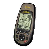
Magellan Meridian Series User Manual (89 pages)
Thales Navigation GPS Receivers User Manual Meridian Series
Brand:
Magellan
| Category:
GPS
| Size: 1.31 MB
Table of Contents
License Agreement
2
Limited Warranty
3
Table of Contents
5
Introduction
11
About this User Manual
11
Setting up the Meridian
11
Basic Operation
11
Installing the Batteries
13
Selecting Language
14
Initialization for First Time Use
14
Turn the Meridian on
14
Enter Your Approximate Position
15
Meridian GPS Receiver
17
Turning Power On/Off
18
Turning the Backlight On/Off
18
Adjusting the Contrast
19
Getting a Position Fix
19
Navigational Screens
19
Map Screen
20
Compass Screen
20
Large Data Screen
20
Position Screens
21
Road Screen
21
Data Screen
21
Speedometer Screen
21
Satellite Status Screen
21
Accessing the Navigation Screens
22
Saving a Waypoint
22
Using GOTO Routes
24
Creating a GOTO Route
24
Navigating on a GOTO Route
26
Summary
27
Power/Backlight/Contrast
28
Turn the Meridian on
28
Turn the Meridian off
28
Using the Display Backlight
28
Adjusting the Display Contrast
29
Selecting NAV Screens
29
Returning to Last Viewed NAV Screen
29
Map Screen
29
Setting the Map Detail
32
Customizing the Map Display
33
Turning On/Off Display Waypoints
33
Turning On/Off Topographic Lines
33
Turning On/Off Track Lines
33
Globally Turning Map Items On/Off
34
Turning On/Off Displayed Poi's
34
Setting up Map Data Fields
34
Changing the Data Fields
35
Selecting the Data Fields
35
Turning Data Fields On/Off
35
Two Data Fields Description
35
Horizontal Profile Description
37
Street Information Description
37
Terrain Projection Description
37
Changing the Map Orientation
38
Selecting Primary Usage
38
Selecting Track Mode
39
Auto Vs. Auto Detailed
39
Using Vertical Profile
40
Selecting Vertical Profile
40
Track History Description
40
Highlighted Road Vertical Profile Description
41
Path Check Description
41
Route Vertical Profile Description
41
Compass Screen
43
Customizing the Data Fields
43
Large Data Screen
43
Customizing the Data Fields
44
Position Screen
44
Selecting the Position Screen
44
Resetting the Trip Odometer
44
Customizing the Data Fields
45
GPS Status Messages
46
Selecting Coordinate System, Map Datum and Elevation Mode
46
Road Screen
47
Customizing the Data Fields
48
Data Screen
49
Customizing the Data Fields
49
Speed Screen
50
Customizing the Data Fields
50
Satellite Status Screen
50
Waypoints / Database
51
Accessing Waypoints in the Database
51
Selecting Waypoints from the Nearest List
51
Selecting Waypoints from the Alphabetical List
51
Selecting Waypoints Nearest to the Cursor
52
Saving Present Position as a Waypoint
52
Creating New Waypoint Manually
53
Creating New Waypoint with Map Cursor
53
Deleting a User Waypoint
53
Editing a User Waypoint
54
Viewing a Map Object on the Map
54
Viewing a User Waypoint on the Map
54
Saving a Map Object as a User Waypoint
55
Searching for a Street Address
55
Creating a GOTO Route
56
Creating a Backtrack Route
56
Routes
57
Creating a Multileg Route
57
Activating/Deactivating a Route
59
Viewing a Route
59
Editing a Route
59
Deleting a Leg
60
Inserting a Leg
60
Replacing a Leg
60
Appending a Leg
61
Appending a Newly Created Waypoint to a Route
61
Reversing a Route
61
Deleting a Route
61
Viewing a Route on the Map Screen
62
Creating a Route Using Track History
62
Setup
62
Initializing the Meridian
62
Turning the NAV Screens On/Off
63
Selecting the Coordinate System
63
Selecting a Map Datum
64
Selecting the Elevation Mode
64
Selecting the Time Format
64
Selecting NAV Units
65
Selecting the North Reference
65
Setting the Backlight Timer
65
Turning the Beeper On/Off
66
Selecting NMEA Message
66
Selecting the Baud Rate
66
Clearing Memory
67
Clearing Track History
67
Clearing Wpts/Routes
67
Clearing All Routes
67
Resetting Meridian to Factory Defaults
67
Clearing All Memory in the Meridian
67
Changing Languages
68
Sun/Moon Display
68
Accessing the Sun/Moon Screen
68
Changing the Sun/Moon Date
68
Changing the Sun/Moon Position
69
Fish/Hunt Times Display
69
Accessing the Fish/Hunt Screen
69
Changing the Fish/Hunt Date
69
Changing the Fish/Hunt Position
69
Meridian Alarms
70
Setting the Arrival Alarm
70
Setting the Anchor Alarm
70
Setting the XTE Alarm
70
Setting the GPS Fix Alarm
70
Using the Simulator
71
Turning on the Simulator - Auto Mode
71
Turning on the Simulator - User Mode
71
Turning the Simulator off
71
About
72
Help
72
Reference
28
Frequently Asked Questions
73
General
73
Waypoints/Database
74
Navigation Screens
75
Routes
75
Alarms
76
Output Data
76
Appendix
78
Troubleshooting
79
Accessories
81
Mapsend™ Streets
82
Waas
86
Magellan Meridian Series User Manual (86 pages)
Brand:
Magellan
| Category:
GPS
| Size: 7.9 MB
Table of Contents
License Agreement
2
Table of Contents
3
Introduction
9
About this User Manual
9
Setting up the Meridian
9
Basic Operation
9
Installing the Batteries
11
Selecting Language
12
Initialization for First Time Use
12
Turn the Meridian on
12
Enter Your Approximate Position
13
Meridian GPS Receiver
15
Turning Power On/Off
16
Turning the Backlight On/Off
16
Adjusting the Contrast
17
Getting a Position Fix
17
Navigational Screens
17
Map Screen
18
Compass Screen
18
Large Data Screen
18
Position Screens
19
Road Screen
19
Data Screen
19
Speedometer Screen
19
Satellite Status Screen
19
Accessing the Navigation Screens
20
Saving a Waypoint
20
Using GOTO Routes
22
Creating a GOTO Route
22
Navigating on a GOTO Route
24
Summary
25
Power/Backlight/Contrast
26
Turn the Meridian on
26
Turn the Meridian off
26
Using the Display Backlight
26
Adjusting the Display Contrast
27
Selecting NAV Screens
27
Returning to Last Viewed NAV Screen
27
Map Screen
27
Setting the Map Detail
30
Customizing the Map Display
31
Turning On/Off Display Waypoints
31
Turning On/Off Topographic Lines
31
Turning On/Off Track Lines
31
Globally Turning Map Items On/Off
32
Turning On/Off Displayed Poi's
32
Setting up Map Data Fields
32
Changing the Data Fields
33
Selecting the Data Fields
33
Turning Data Fields On/Off
33
Two Data Fields Description
33
Horizontal Profile Description
35
Street Information Description
35
Terrain Projection Description
35
Changing the Map Orientation
36
Selecting Primary Usage
36
Selecting Track Mode
37
Auto Vs. Auto Detailed
37
Using Vertical Profile
38
Selecting Vertical Profile
38
Track History Description
38
Highlighted Road Vertical Profile Description
39
Path Check Description
39
Route Vertical Profile Description
39
Compass Screen
40
Customizing the Data Fields
41
Large Data Screen
41
Customizing the Data Fields
42
Position Screen
42
Selecting the Position Screen
42
Resetting the Trip Odometer
42
Customizing the Data Fields
43
GPS Status Messages
44
Selecting Coordinate System, Map Datum and Elevation Mode
44
Road Screen
45
Customizing the Data Fields
46
Data Screen
46
Customizing the Data Fields
47
Speed Screen
47
Customizing the Data Fields
48
Satellite Status Screen
48
Waypoints / Database
49
Accessing Waypoints in the Database
49
Selecting Waypoints from the Nearest List
49
Selecting Waypoints from the Alphabetical List
49
Selecting Waypoints Nearest to the Cursor
50
Saving Present Position as a Waypoint
50
Creating New Waypoint Manually
51
Creating New Waypoint with Map Cursor
51
Deleting a User Waypoint
51
Editing a User Waypoint
52
Viewing a Map Object on the Map
52
Viewing a User Waypoint on the Map
52
Saving a Map Object as a User Waypoint
53
Searching for a Street Address
53
Routes
54
Creating a GOTO Route
54
Creating a Backtrack Route
54
Creating a Multileg Route
55
Activating/Deactivating a Route
57
Viewing a Route
57
Editing a Route
57
Deleting a Leg
58
Inserting a Leg
58
Replacing a Leg
58
Appending a Leg
59
Appending a Newly Created Waypoint to a Route
59
Reversing a Route
59
Deleting a Route
59
Viewing a Route on the Map Screen
60
Creating a Route Using Track History
60
Setup
60
Initializing the Meridian
60
Turning the NAV Screens On/Off
61
Selecting the Coordinate System
61
Selecting a Map Datum
62
Selecting the Elevation Mode
62
Selecting the Time Format
62
Selecting NAV Units
63
Selecting the North Reference
63
Setting the Backlight Timer
63
Turning the Beeper On/Off
64
Selecting NMEA Message
64
Selecting the Baud Rate
64
Clearing Memory
65
Clearing Track History
65
Clearing Wpts/Routes
65
Clearing All Routes
65
Resetting Meridian to Factory Defaults
65
Clearing All Memory in the Meridian
65
Changing Languages
66
Sun/Moon Display
66
Accessing the Sun/Moon Screen
66
Changing the Sun/Moon Date
66
Changing the Sun/Moon Position
67
Fish/Hunt Times Display
67
Accessing the Fish/Hunt Screen
67
Changing the Fish/Hunt Date
67
Changing the Fish/Hunt Position
67
Meridian Alarms
68
Setting the Arrival Alarm
68
Setting the Anchor Alarm
68
Setting the XTE Alarm
68
Setting the GPS Fix Alarm
68
Using the Simulator
69
Turning on the Simulator - Auto Mode
69
Turning on the Simulator - User Mode
69
Turning the Simulator off
69
About
70
Help
70
Reference
26
Frequently Asked Questions
71
General
71
Waypoints/Database
72
Navigation Screens
73
Routes
73
Alarms
74
Output Data
74
Troubleshooting
77
Accessories
79
Waas
83
Advertisement
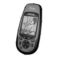
Magellan Meridian Series Frequently Asked Questions Manual (30 pages)
Magellan Meridian FAQ User Manual
Brand:
Magellan
| Category:
GPS
| Size: 0.16 MB
Table of Contents
Table of Contents
2
Introduction
4
Model
4
Which Model for Me
4
Various Models -- What's the Difference
4
Difference between Magellan Sportrak and Meridian GPS Receivers
4
What Does the Compass and Barometer on the Platinum Do
5
Memory and Maps - the Overview
5
Base Maps -- What's the Deal
6
Where Do I Find Basemaps
7
Memory Expansion (SD Card) -- How Do I Do It, and What's It for
7
Memory Usage - How Much Memory Is Left
8
Detailed Maps -- How Do I Do It
8
Detailed Maps -- What if I Don't Have a Base Map
8
Detailed Maps -- What Software Is Available
8
Detailed Maps -- Why Are They so Bad
9
Detailed Maps -- How Do I Use more than 1 Map File
9
Detailed Maps -- Can I Use Non-Magellan Software or Make My Own Maps
10
Mapsend Topo -- How Detailed Is It
10
Mapsend Topo -- Where Do I Find the 4.20 Patch for My V3.XX Topo
10
Combining Mapsend Products (Method 1 - Australia Mapsend Streets)
11
Combining Mapsend Products (Method 2 -Mapsend Europe and USA)
11
What Other Software Is Available
12
Serial Communications with Other Software
12
How Do I Actually Use My Magellan GPS
12
Fun Things to Do with Your GPS
14
What if I Don't Use Windows
14
WAAS - What It Is, Do I Need It, and Can I Turn It off
14
What Are All of These Secret Menus
15
Secret Key Combinations
16
Upgrading the "Lawyer" Screen
16
Upgrading the "Copyright" Screen
16
Emergency Firmware Restoration
17
Base Map Replacement (Gold/Marine/Platinum/Color)
17
Basemap Replacement (Green & Yellow)
18
Base Map Backup
19
Build Your Own Trail Maps
20
Change the Meridian Icons
22
How Do I Measure the Distance between Two Points
22
Can I Use Rechargeable Batteries
22
What Is the 'Simulate' Function for
22
Setting up a User Grid
23
Use Mapsend WW Basemap with Bluenav Charts
23
Troubleshooting -- My GPS Is Shutting down Every few Minutes
24
Troubleshooting -- Mymeridian Reports "Bad Data
25
Troubleshooting -- Can't Calibrate the Thermometer or Barometer
25
Troubleshooting -- the Goto Line Doesn't Move with My Position
25
Troubleshooting -- Why am I Having Problems with Projections
25
Troubleshooting - My Tracks Have the Wrong Time Stamp
25
Troubleshooting -- Topo, Streets and SD Cards
25
Troubleshooting - SD Cards and Windows XP
26
Troubleshooting - Map Size Limits
26
Troubleshooting - Meridian Green or Yellow Loss of Waypoints and Routes
26
Troubleshooting - My Battery Compartment Door Does Not Fit Right
27
Troubleshooting - the Contact Area on My Unit Is Missing Its Cover
27
Troubleshooting -- Mapsend Won't Read Tracks/Waypoints from SD Card
27
Troubleshooting - Screen Spots
27
Troubleshooting -- My Platinum's Compass Doesn't Calibrate
27
Troubleshooting - Low Battery Warning
27
Troubleshooting - Sandisk SD Card Incompatibility
28
Troubleshooting -- COM Port Is 'Busy
28
Troubleshooting -- Mapsend Is Taking Forever to Generate a Map
28
Troubleshooting -- Topo Map Size
28
Troubleshooting -- 128MB and Larger SD Cards
29
Where to Go for more Information
29
Credits & Thanks
30
Magellan Meridian Series Quick Start Manual (21 pages)
Brand:
Magellan
| Category:
GPS
| Size: 1.77 MB
Table of Contents
Table of Contents
4
Setting up the Meridian
5
Installing the Batteries
5
Initialization for First Time Use
5
Optional Setup Functions
9
Basic Operation
9
Turning Power On/Off
10
Introduction
10
Turning the Backlight On/Off
11
Adjusting the Contrast
11
Getting a Position Fix
12
Navigation Screens
12
Accessing the NAV Screens
15
Saving a Waypoint
15
Using GOTO Routes
18
Creating a GOTO Route
18
Navigating on a GOTO Route
21
Advertisement
Related Products
Magellan Meridian Platinum
Magellan Meridian Marine - Hiking GPS Receiver
Magellan Meridian XL
Magellan Meridian Gold
Magellan Meridian Marine
Magellan MobileMapper CX - Hiking GPS Receiver
Magellan MobileMapper MobileMapper 6
Magellan MAP 330
Magellan MAP 330 Series
Magellan MobileMapper - GPS Software
Magellan Categories
GPS
Car Navigation system
Security System
Keypad
Tent
More Magellan Manuals
Login
Sign In
OR
Sign in with Facebook
Sign in with Google
Upload manual
Upload from disk
Upload from URL