Sign In
Upload
Manuals
Brands
Garmin Manuals
Marine Equipment
ECHOMAP UHD
Garmin ECHOMAP UHD Manuals
Manuals and User Guides for Garmin ECHOMAP UHD. We have
5
Garmin ECHOMAP UHD manuals available for free PDF download: Manual, Owner's Manual, Installation Instructions Manual
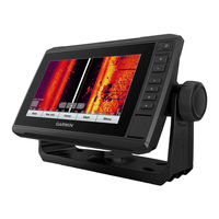
Garmin ECHOMAP UHD Manual (260 pages)
Brand:
Garmin
| Category:
Fish Finder
| Size: 10.93 MB
Table of Contents
Table of Contents
3
Sadržaj
4
Uvod
9
Prednji Prikaz Uređaja ECHOMAP UHD 60
10
Tipke Uređaja
11
Pregled Priključaka Uređaja ECHOMAP UHD 60
12
Prednji Prikaz Uređaja ECHOMAP UHD 70/90
13
Tipke Uređaja
14
Pregled Priključaka Uređaja ECHOMAP UHD 70/90
15
Dodjeljivanje Tipke Prečaca
16
Savjeti I Prečaci
16
Pristup Priručnicima Na Internetu
17
Umetanje Memorijskih Kartica
18
Primanje Signala GPS Satelita
19
Odabir Izvora GPS-A
19
Prilagođavanje Plotera
19
Prilagođavanje Početnog Zaslona
20
Prilagođavanje Stranica
20
Stvaranje Nove Kombinirane Stranice Pomoću Uređaja ECHOMAP UHD 70/90
21
Stvaranje Nove Kombinirane Stranice Pomoću Uređaja ECHOMAP UHD 60
22
Prilagođavanje Preklapanja Podataka
23
Postavljanje Vrste Plovila
24
Prilagođavanje Pozadinskog Osvjetljenja
24
Podešavanje Rada Boja
24
Promjena Pozadinske Slike
25
Aplikacija Activecaptain
25
Activecaptain Uloge
26
Početak Rada S Aplikacijom Activecaptain
27
Omogućivanje Pametnih Obavijesti
28
Primanje Obavijesti
29
Upravljanje Obavijestima
30
Postavljanje Privatnih Obavijesti
30
Nadogradnja Softvera Pomoću Aplikacije Activecaptain
31
Nadogradnja Karata S Pomoću Aplikacije Activecaptain
32
Karte I 3D Prikazi Karte
33
Navigacijska Karta I Ribolovna Karta
34
Povećavanje I Smanjivanje Karte Zumiranjem
34
Pomicanje Karte Pomoću Tipki
35
Odabir Stavke Na Karti Pomoću Tipki Uređaja
35
Simboli Karte
36
Mjerenje Udaljenosti Na Karti
36
Stvaranje Točke Na Karti
37
Kretanje Prema Odredištu Na Karti
38
Pregled Informacija O Lokaciji I Objektu Na Karti
39
Pregled Pojedinosti O Navigacijskim Oznakama
39
Linija Smjera I Oznake Kutova
40
Premium Karte
42
Pregled Informacija Stanice Za Predviđanje Morskih Mijena
43
Prikaz Satelitskih Slika Na Navigacijskoj Karti
45
Pregled Fotografija Orijentira Iz Zraka
46
Sustav Za Automatsko Identificiranje
46
Simboli Određivanja AIS Cilja
47
Smjer I Planirani Kurs Aktiviranih AIS Ciljeva
48
Aktivacija Cilja Za AIS Plovilo
48
Prikaz Popisa AIS Prijetnji
49
Postavljanje Alarma Za Sudar U Sigurnoj Zoni
49
AIS Oznake Za Pomoć Pri Navigaciji
50
AIS Signali PomoćI
52
Isključivanje AIS Prijema
54
Izbornik Karte
54
Slojevi Karte
55
Postavke Karte Fish Eye 3D
61
Podržane Karte
61
Detaljne Karte
62
Aktiviranje Pretplate Na Nautičku Kartu
62
Izrada Karata Pomoću Softvera Garmin Quickdraw Contours
63
Izrada Karte Vodene Površine Pomoću Funkcije Garmin Quickdraw Contours
64
Dodavanje Oznake Na Garmin Quickdraw Contours Kartu
64
Garmin Quickdraw Zajednica
65
Povezivanje S Garmin Quickdraw Zajednicom Pomoću Usluge Activecaptain
65
Povezivanje S Garmin Quickdraw Zajednicom Pomoću Usluge Garmin Connect
67
Postavke Softvera Garmin Quickdraw Contours
69
Navigacija Pomoću Plotera
70
Osnovna Pitanja O Navigaciji
71
Označavanje Ruta Bojama
72
Odredišta
72
Pretraživanje Odredišta Prema Nazivu
73
Odabir Odredišta Pomoću Navigacijske Karte
73
Pretraživanje Odredišta Pomorskih Usluga
74
Postavljanje I Praćenje Izravnog Kursa Pomoću Opcije IDI Na
74
Zaustavljanje Navigacije
75
Točke
75
Označavanje Trenutne Lokacije Kao Točke
75
Stvaranje Točke Na Drugoj Lokaciji
76
Označavanje Lokacije Čovjeka U Moru (MOB)
76
Projekcija Točke
77
Pregled Popisa Svih Međutočaka
77
Uređivanje Spremljene Točke
78
Pomicanje Spremljene Točke
78
Pretraživanje I Navigacija Do Spremljene Točke
79
Brisanje Točke Ili Točke MOB
80
Brisanje Svih Međutočaka
80
Rute
80
Stvaranje Rute I Navigiranje S Vaše Trenutne Lokacije
81
Stvaranje I Spremanje Rute
81
Prikaz Popisa Ruta
82
Uređivanje Spremljene Rute
82
Pretraživanje I Navigacija Spremljenom Rutom
83
Pretraživanje I Navigacija Paralelno Sa Spremljenom Rutom
84
Brisanje Spremljene Rute
85
Brisanje Svih Spremljenih Ruta
85
Automatsko Navođenje
86
Postavljanje I Praćenje Puta U Funkciji Autom. Navođ
86
Stvaranje I Spremanje Puta Za Autom
87
Navođ
87
Prilagođavanje Puta Automatskog Navođenja
87
Poništavanje Izračuna Za Autom
88
Navođ. U Tijeku
88
Postavljanje Vremena Dolaska
88
Konfiguracija Putanje Automatskog Navođenja
89
Trase
91
Prikaz Tragova
91
Postavljanje Boje Aktivnog Traga
91
Spremanje Aktivnog Traga
92
Prikaz Popisa Spremljenih Tragova
92
Uređivanje Spremljenog Traga
93
Spremanje Traga Kao Rute
93
Pretraživanje I Navigacija Spremljenim Tragom
94
Brisanje Spremljenog Traga
94
Brisanje Svih Spremljenih Trasa
95
Ponovno Kretanje Aktivnim Tragom
95
Brisanje Aktivnog Traga
95
Upravljanje Memorijom Zapisnika Traga Tijekom Snimanja
96
Konfiguriranje Intervala Snimanja Zapisnika Traga
96
Granice
97
Stvaranje Granice
97
Pretvaranje Rute U Granicu
98
Pretvaranje Traga U Granicu
98
Uređivanje Granice
98
Postavljanje Alarma Granice
99
Brisanje Granice
99
Brisanje Svih Spremljenih Točaka, Tragova, Ruta I Granica
100
Jedriličarske Značajke
100
Postavljanje Vrste Plovila Za Jedriličarske Funkcije
100
Jedriličarska Utrka
101
Pomoć Do Startne Linije
101
Korištenje Štoperice
103
Postavljanje Udaljenosti Između Pramca I GPS Antene
103
Postavke Layline Linija
104
Postavljanje Dubine Kobilice
105
Rad Autopilota Na Jedrilici
106
Držanje Uz Vjetar
106
Okret Uz Vjetar I Okret Niz Vjetar
108
Linija Smjera I Oznake Kutova
109
Postavljanje Linije Smjera I Oznake Kutova
110
Prikaz Podataka O Plovilu
110
Sonar Fishfinder Uređaja
111
Prekid Odašiljanja Signala Sonara
111
Prikaz Uobičajeno Sonara
112
Prikaz Sonara Podijeljene Frekvencije
112
Prikaz Sonara S Podijeljenim Zumiranjem
113
Prikaz Bljeskalice
114
Prečaci Do Stranice Bljeskalice
115
Garmin Clearvü Prikaz Sonara
116
Garmin Sidevü™ Prikaz Sonara
117
Sidevü Tehnologija Skeniranja
118
Mjerenje Udaljenosti Na Zaslonu Sonara
118
Prikazi Panoptix Sonara
119
Prikaz Donjeg Livevü Sonara
120
Prikaz Prednjeg Livevü Sonara
121
Prikaz Prednjeg Realvü 3D Sonara
122
Prikaz Donjeg Donji Realvü 3D Sonara
123
Prikaz Povijesnog Realvü 3D Sonara
124
Frontvü Prikaz Sonara
125
Livescope Prikaz Sonara
126
Prikaz Perspektiva
127
Odabir Vrste Sonde
128
Kalibracija Kompasa
129
Odabir Izvora Sonara
129
Promjena Naziva Izvora Sonara
130
Stvaranje Točke Na Zaslonu Sonara
130
Pauziranje Prikaza Sonara
131
Pregled Povijesti Sonara
131
Dijeljenje Sonara
132
Podešavanje Razine Detalja
132
Prilagođavanje Intenziteta Boje
133
Postavljanje Standardnog, Garmin Clearvü, I Sidevü Sonara
134
Postavljanje Razine Zumiranja Na Zaslonu Sonara
135
Postavljanje Brzine Pomicanja
135
Podešavanje Dometa
136
Postavke Izgleda Sonara
137
Alarmi Sonara
138
Napredne Postavke Sonara
139
Postavke Instalacije Sonde
140
Frekvencije Sonara
141
Uključivanje Funkcije A-Scope
143
Postavke Sonara Panoptix
143
Prilagođavanje Realvü Kuta Gledanja I Razine Zumiranja
144
Prilagođavanje Brzine Odašiljanja Za Realvü
144
Postavke Sonara Livevü Forward I Frontvü
145
Postavke Izgleda Za Livevü I Frontvü
147
Postavke Izgleda Za Realvü
147
Postavke Sonara Livescope I Perspektiva
148
Postavke Instalacije Panoptix Sonde
151
Autopilot
153
Zaslon Autopilota
154
Prilagođavanje Veličine Koraka Upravljanja
154
Postavljanje Uštede Energije
155
Odabir Preferiranog Izvora Smjera
155
Omogućivanje Značajke Shadow Drive
156
Uključivanje Autopilota
156
Prilagođavanje Smjera S Pomoću Kormila
157
Prilagođavanje Smjera Pomoću Plotera U Načinu Upravljanja U Koracima
157
Oblici Za Upravljanje
158
Slijeđenje Oblika Polukružnog Zaokreta
158
Postavljanje I Slijeđenje Kružnog Oblika
158
Postavljanje I Slijeđenje Cik-Cak Oblika
159
Slijeđenje Oblika Williamsonovog Zaokreta
159
Reactor™ Daljinski Upravljač Za Sustav Autopilota
160
Uparivanje Reactor Daljinskog Upravljača Za Sustav Autopilota I Plotera
160
Promjena Funkcija Tipki Za Akciju Na Reactor Daljinskom Upravljaču Za Sustav Autopilota
161
Upravljanje Force® Vanbrodskim Motorom
161
Povezivanje S Vanbrodskim Motorom
162
Dodavanje Kontrola Vanbrodskog Motora Zaslonima
162
Upravljačka Traka Vanbrodskog Motora
163
Postavke Vanbrodskog Motora
164
Dodjela Prečaca Tipkama Prečaca Daljinskog Upravljača Za Vanbrodski Motor
165
Kalibracija Kompasa Vanbrodskog Motora
165
Postavljanje Pomaka Pramca
166
Digitalno Selektivno Pozivanje
166
Ploter I Funkcija NMEA 0183 VHF Radija
167
Uključivanje DSC-A
167
DSC Popis
167
Pregled DSC Popisa
168
Dodavanje DSC Kontakta
168
Dolazni Pozivi U Pomoć
168
Kretanje Prema Plovilu U Nevolji
169
Praćenje Položaja
169
Pregled Izvješća O Položaju
170
Kretanje Prema Praćenom Plovilu
170
Stvaranje Međutočke Na Položaju Praćenog Plovila
170
Uređivanje Informacija U Izvješću O Položaju
171
Brisanje Poziva Za Izvješće O Položaju
171
Staze Plovila Na Karti
172
Pojedinačni Rutinski Pozivi
172
Odabir DSC Kanala
173
Upućivanje Pojedinačnog Rutinskog Poziva
173
Upućivanje Pojedinačnog Rutinskog Poziva AIS Cilju
174
MjeračI I Grafikoni
174
Čitanje Kompasa
174
Pregled Mjerača Puta
175
Ponovno Postavljanje Mjerača Puta
175
Prikaz Mjerača Goriva I Motora
176
Ikone Upozorenja Motora
176
Odabir Broja Motora Prikazanih Na Mjeračima
177
Prilagođavanje Motora Prikazanih Na Mjeračima
177
Omogućavanje Alarma Statusa Za Mjerače Rada Motora
178
Omogućavanje Nekih Alarma Statusa Mjerača Goriva
178
Postavljanje Alarma Za Gorivo
179
Postavljanje Kapaciteta Goriva Za Plovilo
179
Sinkroniziranje Podataka O Gorivu Sa Stvarnom Količinom Goriva U Plovilu
180
Prikaz Mjerača Vjetra
180
Konfiguriranje Mjerača Vjetra Za Jedrenje
181
Konfiguriranje Izvora Brzine
181
Konfiguriranje Izvora Smjera Za Mjerač Vjetra
182
Prilagođavanje Mjerača Vjetra Kod Plovidbe Oštro Uz Vjetar
182
Prilagođavanje Ograničenja Mjerača Motora I Mjerača Goriva
183
MjeračI Mercury® Motora
183
Upravljanje Opremom Treće Strane Koja Je Instalirana Na Vaše Plovilo
185
Sustav Sidra Power-Pole
185
Omogućivanje Preklapanja Sustavom Sidra Power-Pole
185
Postavljanje Sidra Power-Pole
186
Preklapanje Sustavom Power-Pole
187
Omogućavanje Funkcije Mercury Kormilo
188
Funkcije Za Upravljanje Mercury Troll
188
Dodavanje Preklapanja Za Funkciju Upravljanja Mercury Troll
189
Preklapanje Funkcijom Mercury Troll
190
Održavanje Konstantne Brzine Motora Mercury
191
Omogućivanje Preklapanja Funkcijom Održavanja Konstantne Brzine Motora Mercury
191
Konstantne Brzine Motora Mercury
192
Pojedinosti O Motoru Mercury
192
Dodavanje Preklapanja Za Motor Mercury
193
Advertisement
Garmin ECHOMAP UHD Owner's Manual (134 pages)
Brand:
Garmin
| Category:
Marine Equipment
| Size: 10.37 MB
Table of Contents
Table of Contents
3
Introduction
9
ECHOMAP UHD 60 Front View
9
Device Keys
10
ECHOMAP UHD 60 Connector View
10
ECHOMAP UHD 70/90 Front View
11
Device Keys
11
ECHOMAP UHD 70/90 Connector View
12
Assigning a Shortcut Key
12
Tips and Shortcuts
12
Accessing the Manuals from the Web
13
Inserting Memory Cards
13
Acquiring GPS Satellite Signals
13
Selecting the GPS Source
14
Customizing the Chartplotter
14
Customizing the Home Screen
14
Customizing Pages
14
Creating a New Combination Page with the ECHOMAP UHD 70/90
14
Creating a New Combination Page with the ECHOMAP UHD 60
15
Customizing the Data Overlays
16
Setting the Vessel Type
16
Adjusting the Backlight
16
Adjusting the Color Mode
16
Changing the Background Image
17
Activecaptain App
17
Activecaptain Roles
17
Getting Started with the Activecaptain App
18
Enabling Smart Notifications
18
Receiving Notifications
19
Managing Notifications
19
Making Notifications Private
19
Updating Software with the Activecaptain App
20
Updating Charts with Activecaptain
20
Charts and 3D Chart Views
21
Navigation Chart and Fishing Chart
21
Zooming in and out of the Chart
21
Panning the Chart with the Keys
22
Selecting an Item on the Map Using the Device Keys
22
Chart Symbols
22
Measuring a Distance on the Chart
22
Creating a Waypoint on the Chart
22
Navigating to a Point on the Chart
23
Viewing Location and Object Information on a Chart
23
Viewing Details about Navaids
23
Heading Line and Angle Markers
24
Premium Charts
25
Viewing Tide Station Information
25
Showing Satellite Imagery on the Navigation Chart
26
Viewing Aerial Photos of Landmarks
27
Automatic Identification System
27
AIS Targeting Symbols
27
Heading and Projected Course of Activated AIS Targets
28
Activating a Target for an AIS Vessel
28
Viewing a List of AIS Threats
28
Setting the Safe-Zone Collision Alarm
28
AIS Aids to Navigation
29
AIS Distress Signals
30
Turning off AIS Reception
30
Chart Menu
31
Chart Layers
31
Fish Eye 3D Settings
34
Supported Maps
34
Garmin Quickdraw Contours Mapping
35
Mapping a Body of Water Using the Garmin Quickdraw Contours Feature
35
Adding a Label to a Garmin Quickdraw Contours Map
35
Garmin Quickdraw Community
36
Connecting to the Garmin Quickdraw Community with Activecaptain
36
Connecting to the Garmin Quickdraw Community with Garmin Connect
36
Garmin Quickdraw Contours Settings
38
Navigation with a Chartplotter
38
Basic Navigation Questions
39
Route Color Coding
39
Destinations
40
Searching for a Destination by Name
40
Selecting a Destination Using the Navigation Chart
40
Searching for a Marine Services Destination
40
Setting and Following a Direct Course Using Go to
40
Stopping Navigation
40
Waypoints
41
Marking Your Present Location as a Waypoint
41
Creating a Waypoint at a Different Location
41
Marking an MOB Location
41
Projecting a Waypoint
41
Viewing a List of All Waypoints
41
Editing a Saved Waypoint
41
Moving a Saved Waypoint
42
Browsing for and Navigating to a Saved Waypoint
42
Deleting a Waypoint or an MOB
42
Deleting All Waypoints
42
Routes
43
Creating and Navigating a Route from Your Present Location
43
Creating and Saving a Route
43
Viewing a List of Routes
43
Editing a Saved Route
43
Browsing for and Navigating a Saved Route
44
Browsing for and Navigating Parallel to a Saved Route
44
Deleting a Saved Route
44
Deleting All Saved Routes
44
Auto Guidance
45
Setting and Following an Auto Guidance Path
45
Creating and Saving an Auto Guidance Path
45
Adjusting an Auto Guidance Path
45
Canceling an Auto Guidance Calculation in Progress
46
Setting a Timed Arrival
46
Auto Guidance Path Configurations
46
Tracks
47
Showing Tracks
47
Setting the Color of the Active Track
47
Saving the Active Track
48
Viewing a List of Saved Tracks
48
Editing a Saved Track
48
Saving a Track as a Route
48
Browsing for and Navigating a Recorded Track
48
Deleting a Saved Track
48
Deleting All Saved Tracks
48
Retracing the Active Track
49
Clearing the Active Track
49
Managing the Track Log Memory During Recording
49
Configuring the Recording Interval of the Track Log
49
Boundaries
49
Creating a Boundary
49
Converting a Route to a Boundary
50
Converting a Track to a Boundary
50
Editing a Boundary
50
Setting a Boundary Alarm
50
Deleting a Boundary
50
Deleting All Saved Waypoints, Tracks, Routes, and Boundaries
50
Sailing Features
50
Setting the Vessel Type for Sailing Features
50
Sail Racing
51
Starting Line Guidance
51
Using the Race Timer
51
Setting the Distance between the Bow and the GPS Antenna
51
Laylines Settings
52
Setting the Keel Offset
53
Sailboat Autopilot Operation
53
Wind Hold
54
Tack and Gybe
54
Heading Line and Angle Markers
55
Setting the Heading Line and Angle Markers
55
Viewing Sailing Vessel Data
55
Sonar Fishfinder
56
Stopping the Transmission of Sonar Signals
56
Traditional Sonar View
56
Split-Frequency Sonar View
56
Split-Zoom Sonar View
56
Flasher View
57
Flasher Page Shortcuts
58
Garmin Clearvü Sonar View
59
Garmin Sidevü™ Sonar View
60
Sidevü Scanning Technology
61
Measuring Distance on the Sonar Screen
61
Panoptix Sonar Views
61
Livevü down Sonar View
62
Livevü Forward Sonar View
63
Realvü 3D Forward Sonar View
64
Realvü 3D down Sonar View
65
Realvü 3D Historical Sonar View
66
Frontvü Sonar View
67
Livescope Sonar View
67
Perspective View
68
Selecting the Transducer Type
68
Calibrating the Compass
69
Selecting a Sonar Source
69
Renaming a Sonar Source
69
Creating a Waypoint on the Sonar Screen
69
Pausing the Sonar Display
69
Viewing Sonar History
70
Sonar Sharing
70
Adjusting the Level of Detail
70
Adjusting the Color Intensity
71
Traditional, Garmin Clearvü, and Sidevü Sonar Setup
71
Setting the Zoom Level on the Sonar Screen
71
Setting the Scroll Speed
72
Adjusting the Range
72
Sonar Appearance Settings
73
Sonar Alarms
73
Advanced Sonar Settings
74
Transducer Installation Settings
74
Sonar Frequencies
75
Turning on the A-Scope
76
Panoptix Sonar Setup
76
Adjusting the Realvü Viewing Angle and Zoom Level
76
Adjusting the Realvü Sweep Speed
76
Livevü Forward and Frontvü Sonar Settings
77
Livevü and Frontvü Appearance Settings
78
Realvü Appearance Settings
78
Livescope and Perspective Sonar Settings
79
Panoptix Transducer Installation Settings
80
Autopilot
81
Autopilot Screen
82
Adjusting the Step Steering Increment
82
Setting the Power Saver
82
Selecting the Preferred Heading Source
83
Enabling the Shadow Drive™ Feature
83
Engaging the Autopilot
83
Adjusting the Heading Using the Helm
83
Adjusting the Heading with the Chartplotter in Step Steering Mode
83
Steering Patterns
84
Following the U-Turn Pattern
84
Setting up and Following the Circles Pattern
84
Setting up and Following the Zigzag Pattern
84
Following the Williamson Turn Pattern
84
Reactor™ Autopilot Remote Control
84
Pairing a Reactor Autopilot Remote Control with a Chartplotter
85
Changing the Functions of the Reactor Autopilot Remote Control Action Keys
85
Force® Trolling Motor Control
85
Connecting to a Trolling Motor
85
Adding the Trolling Motor Controls to Screens
86
Trolling Motor Control Bar
86
Trolling Motor Settings
87
Assigning a Shortcut to the Trolling Motor Remote Control Shortcut Keys
87
Calibrating the Trolling Motor Compass
87
Setting the Bow Offset
88
Digital Selective Calling
88
Chartplotter and NMEA 0183 VHF Radio Functionality
88
Turning on DSC
88
DSC List
88
Viewing the DSC List
88
Adding a DSC Contact
88
Incoming Distress Calls
89
Navigating to a Vessel in Distress
89
Position Tracking
89
Viewing a Position Report
89
Navigating to a Tracked Vessel
89
Creating a Waypoint at the Position of a Tracked Vessel
89
Editing Information in a Position Report
90
Deleting a Position-Report Call
90
Viewing Vessel Trails on the Chart
90
Individual Routine Calls
90
Selecting a DSC Channel
90
Making an Individual Routine Call
90
Making an Individual Routine Call to an AIS Target
91
Gauges and Graphs
91
Viewing the Compass
91
Viewing Trip Gauges
91
Resetting Trip Gauges
91
Viewing Engine and Fuel Gauges
91
Engine Alert Icons
92
Selecting the Number of Engines Shown in Gauges
92
Customizing the Engines Shown in Gauges
92
Enabling Status Alarms for Engine Gauges
92
Enabling some Engine Gauge Status Alarms
92
Setting the Fuel Alarm
92
Setting the Fuel Capacity of the Vessel
93
Synchronizing the Fuel Data with the Actual Vessel Fuel
93
Viewing the Wind Gauges
93
Configuring the Sailing Wind Gauge
93
Configuring the Speed Source
93
Configuring the Heading Source of the Wind Gauge
93
Customizing the Close-Hauled Wind Gauge
94
Customizing Engine Gauge and Fuel Gauge Limits
94
Mercury Engine Gauges
94
Controlling Third-Party Equipment Installed on Your Boat
96
Power-Pole Anchor System
96
Enabling the Power-Pole Anchor Overlay
96
Setting up the Power-Pole Anchor
96
Power-Pole Overlay
97
Enabling the Mercury Helm
97
Mercury Troll Control Features
97
Adding the Mercury Troll Control Overlay
98
Mercury Troll Overlay
98
Mercury Cruise Control
98
Enabling the Mercury Cruise Control Overlay
98
Mercury Cruise Control Overlay
99
Mercury Engine Details
99
Adding the Mercury Engine Overlay
99
Mercury Engine Overlay
100
Garmin ECHOMAP UHD Owner's Manual (132 pages)
Brand:
Garmin
| Category:
GPS
| Size: 9.95 MB
Table of Contents
Table of Contents
3
Introduction
9
ECHOMAP UHD 60 Front View
9
Device Keys
10
ECHOMAP UHD 60 Connector View
10
ECHOMAP UHD 70/90 Front View
11
Device Keys
11
ECHOMAP UHD 70/90 Connector View
12
Assigning a Shortcut Key
12
Tips and Shortcuts
12
Accessing the Manuals from the Web
13
Inserting Memory Cards
13
Acquiring GPS Satellite Signals
13
Selecting the GPS Source
14
Customizing the Chartplotter
14
Customizing the Home Screen
14
Customizing Pages
14
Creating a New Combination Page with the ECHOMAP UHD 70/90
14
Creating a New Combination Page with the ECHOMAP UHD 60
15
Customizing the Data Overlays
16
Setting the Vessel Type
16
Adjusting the Backlight
16
Adjusting the Color Mode
16
Changing the Background Image
17
Activecaptain App
17
Activecaptain Roles
17
Getting Started with the Activecaptain App
18
Enabling Smart Notifications
18
Receiving Notifications
19
Managing Notifications
19
Making Notifications Private
19
Updating Software with the Activecaptain App
20
Updating Charts with Activecaptain
20
Charts and 3D Chart Views
21
Navigation Chart and Fishing Chart
21
Zooming in and out of the Chart
21
Panning the Chart with the Keys
22
Selecting an Item on the Map Using the Device Keys
22
Chart Symbols
22
Measuring a Distance on the Chart
22
Creating a Waypoint on the Chart
22
Navigating to a Point on the Chart
23
Viewing Location and Object Information on a Chart
23
Viewing Details about Navaids
23
Heading Line and Angle Markers
24
Premium Charts
25
Viewing Tide Station Information
25
Showing Satellite Imagery on the Navigation Chart
26
Viewing Aerial Photos of Landmarks
27
Automatic Identification System
27
AIS Targeting Symbols
27
Heading and Projected Course of Activated AIS Targets
28
Activating a Target for an AIS Vessel
28
Viewing a List of AIS Threats
28
Setting the Safe-Zone Collision Alarm
28
AIS Aids to Navigation
29
AIS Distress Signals
30
Turning off AIS Reception
30
Chart Menu
31
Chart Layers
31
Fish Eye 3D Settings
34
Supported Maps
34
Detailed Charts
35
Activating a Marine Chart Subscription
35
Garmin Quickdraw Contours Mapping
36
Mapping a Body of Water Using the Garmin Quickdraw Contours Feature
36
Adding a Label to a Garmin Quickdraw Contours Map
36
Garmin Quickdraw Community
37
Connecting to the Garmin Quickdraw Community with Activecaptain
37
Connecting to the Garmin Quickdraw Community with Garmin Connect
37
Garmin Quickdraw Contours Settings
39
Navigation with a Chartplotter
39
Basic Navigation Questions
40
Route Color Coding
40
Destinations
41
Searching for a Destination by Name
41
Selecting a Destination Using the Navigation Chart
41
Searching for a Marine Services Destination
41
Setting and Following a Direct Course Using Go to
41
Stopping Navigation
41
Waypoints
42
Marking Your Present Location as a Waypoint
42
Creating a Waypoint at a Different Location
42
Marking an MOB Location
42
Projecting a Waypoint
42
Viewing a List of All Waypoints
42
Editing a Saved Waypoint
42
Moving a Saved Waypoint
43
Browsing for and Navigating to a Saved Waypoint
43
Deleting a Waypoint or an MOB
43
Deleting All Waypoints
43
Routes
44
Creating and Navigating a Route from Your Present Location
44
Creating and Saving a Route
44
Viewing a List of Routes
44
Editing a Saved Route
44
Browsing for and Navigating a Saved Route
45
Browsing for and Navigating Parallel to a Saved Route
45
Deleting a Saved Route
45
Deleting All Saved Routes
45
Auto Guidance
46
Setting and Following an Auto Guidance Path
46
Creating and Saving an Auto Guidance Path
46
Adjusting an Auto Guidance Path
46
Canceling an Auto Guidance Calculation in Progress
47
Setting a Timed Arrival
47
Auto Guidance Path Configurations
47
Tracks
48
Showing Tracks
48
Setting the Color of the Active Track
48
Saving the Active Track
49
Viewing a List of Saved Tracks
49
Editing a Saved Track
49
Saving a Track as a Route
49
Browsing for and Navigating a Recorded Track
49
Deleting a Saved Track
49
Deleting All Saved Tracks
49
Retracing the Active Track
50
Clearing the Active Track
50
Managing the Track Log Memory During Recording
50
Configuring the Recording Interval of the Track Log
50
Boundaries
50
Creating a Boundary
50
Converting a Route to a Boundary
51
Converting a Track to a Boundary
51
Editing a Boundary
51
Setting a Boundary Alarm
51
Deleting a Boundary
51
Deleting All Saved Waypoints, Tracks, Routes, and Boundaries
51
Sailing Features
51
Setting the Vessel Type for Sailing Features
51
Sail Racing
52
Starting Line Guidance
52
Using the Race Timer
52
Setting the Distance between the Bow and the GPS Antenna
52
Laylines Settings
53
Setting the Keel Offset
54
Sailboat Autopilot Operation
54
Wind Hold
55
Tack and Gybe
55
Heading Line and Angle Markers
56
Setting the Heading Line and Angle Markers
56
Viewing Sailing Vessel Data
56
Sonar Fishfinder
57
Stopping the Transmission of Sonar Signals
57
Traditional Sonar View
57
Split-Frequency Sonar View
57
Split-Zoom Sonar View
57
Flasher View
58
Flasher Page Shortcuts
59
Garmin Clearvü Sonar View
60
Garmin Sidevü™ Sonar View
61
Sidevü Scanning Technology
62
Measuring Distance on the Sonar Screen
62
Panoptix Sonar Views
62
Livevü down Sonar View
63
Livevü Forward Sonar View
64
Realvü 3D Forward Sonar View
65
Realvü 3D down Sonar View
66
Realvü 3D Historical Sonar View
67
Frontvü Sonar View
68
Livescope Sonar View
68
Perspective View
69
Selecting the Transducer Type
69
Calibrating the Compass
70
Selecting a Sonar Source
70
Renaming a Sonar Source
70
Creating a Waypoint on the Sonar Screen
70
Pausing the Sonar Display
70
Viewing Sonar History
71
Sonar Sharing
71
Adjusting the Level of Detail
71
Adjusting the Color Intensity
72
Traditional, Garmin Clearvü, and Sidevü Sonar Setup
72
Setting the Zoom Level on the Sonar Screen
72
Setting the Scroll Speed
73
Adjusting the Range
73
Sonar Appearance Settings
74
Sonar Alarms
74
Advanced Sonar Settings
75
Transducer Installation Settings
75
Sonar Frequencies
76
Turning on the A-Scope
77
Panoptix Sonar Setup
77
Adjusting the Realvü Viewing Angle and Zoom Level
77
Adjusting the Realvü Sweep Speed
77
Livevü Forward and Frontvü Sonar Settings
78
Livevü and Frontvü Appearance Settings
79
Realvü Appearance Settings
79
Livescope and Perspective Sonar Settings
80
Panoptix Transducer Installation Settings
81
Autopilot
82
Autopilot Screen
83
Adjusting the Step Steering Increment
83
Setting the Power Saver
83
Selecting the Preferred Heading Source
84
Enabling the Shadow Drive™ Feature
84
Engaging the Autopilot
84
Adjusting the Heading Using the Helm
84
Adjusting the Heading with the Chartplotter in Step Steering Mode
84
Steering Patterns
85
Following the U-Turn Pattern
85
Setting up and Following the Circles Pattern
85
Setting up and Following the Zigzag Pattern
85
Following the Williamson Turn Pattern
85
Reactor™ Autopilot Remote Control
85
Pairing a Reactor Autopilot Remote Control with a Chartplotter
86
Changing the Functions of the Reactor Autopilot Remote Control Action Keys
86
Force® Trolling Motor Control
86
Connecting to a Trolling Motor
86
Adding the Trolling Motor Controls to Screens
87
Trolling Motor Control Bar
87
Trolling Motor Settings
88
Assigning a Shortcut to the Trolling Motor Remote Control Shortcut Keys
88
Calibrating the Trolling Motor Compass
88
Setting the Bow Offset
89
Digital Selective Calling
89
Chartplotter and NMEA 0183 VHF Radio Functionality
89
Turning on DSC
89
DSC List
89
Viewing the DSC List
89
Adding a DSC Contact
89
Incoming Distress Calls
90
Navigating to a Vessel in Distress
90
Position Tracking
90
Viewing a Position Report
90
Navigating to a Tracked Vessel
90
Creating a Waypoint at the Position of a Tracked Vessel
90
Editing Information in a Position Report
91
Deleting a Position-Report Call
91
Viewing Vessel Trails on the Chart
91
Individual Routine Calls
91
Selecting a DSC Channel
91
Making an Individual Routine Call
91
Making an Individual Routine Call to an AIS Target
92
Gauges and Graphs
92
Viewing the Compass
92
Viewing Trip Gauges
92
Resetting Trip Gauges
92
Viewing Engine and Fuel Gauges
92
Engine Alert Icons
93
Selecting the Number of Engines Shown in Gauges
93
Customizing the Engines Shown in Gauges
93
Enabling Status Alarms for Engine Gauges
93
Enabling some Engine Gauge Status Alarms
93
Setting the Fuel Alarm
93
Setting the Fuel Capacity of the Vessel
94
Synchronizing the Fuel Data with the Actual Vessel Fuel
94
Viewing the Wind Gauges
94
Configuring the Sailing Wind Gauge
94
Configuring the Speed Source
94
Configuring the Heading Source of the Wind Gauge
94
Customizing the Close-Hauled Wind Gauge
95
Customizing Engine Gauge and Fuel Gauge Limits
95
Mercury Engine Gauges
95
Controlling Third-Party Equipment Installed on Your Boat
97
Power-Pole Anchor System
97
Enabling the Power-Pole Anchor Overlay
97
Setting up the Power-Pole Anchor
97
Power-Pole Overlay
98
Enabling the Mercury Helm
98
Mercury Troll Control Features
98
Adding the Mercury Troll Control Overlay
99
Mercury Troll Overlay
99
Mercury Cruise Control
99
Enabling the Mercury Cruise Control Overlay
99
Mercury Cruise Control Overlay
100
Mercury Engine Details
100
Adding the Mercury Engine Overlay
100
Mercury Engine Overlay
101
Enabling the Mercury Engine Sport Exhaust Setting
101
Advertisement
Garmin ECHOMAP UHD Owner's Manual (69 pages)
Brand:
Garmin
| Category:
Marine Equipment
| Size: 6.91 MB
Table of Contents
Table of Contents
3
Introduction
7
ECHOMAP UHD 60 Front View
7
Device Keys
7
ECHOMAP UHD 60 Connector View
7
ECHOMAP UHD 70/90 Front View
7
Assigning a Shortcut Key
7
ECHOMAP UHD 70/90 Connector View
7
Tips and Shortcuts
8
Downloading the Manuals from the Web
8
Garmin Support Center
8
Inserting Memory Cards
8
Acquiring GPS Satellite Signals
8
Selecting the GPS Source
8
Customizing the Chartplotter
8
Customizing the Home Screen
8
Customizing Pages
8
Creating a New Combination Page with the ECHOMAP UHD 70/90
8
Creating a New Combination Page with the ECHOMAP UHD 60
9
Customizing the Data Overlays
9
Setting the Vessel Type
9
Adjusting the Backlight
9
Adjusting the Color Mode
9
Changing the Background Image
9
Activecaptain App
9
Activecaptain Roles
9
Getting Started with the Activecaptain App
9
Enabling Smart Notifications
10
Updating Software with the Activecaptain App
10
Updating Charts with Activecaptain
10
Charts and 3D Chart Views
10
Navigation Chart and Fishing Chart
11
Zooming in and out of the Chart
11
Panning the Chart with the Keys
11
Selecting an Item on the Map Using the Device Keys
11
Chart Symbols
11
Measuring a Distance on the Chart
11
Creating a Waypoint on the Chart
11
Navigating to a Point on the Chart
11
Viewing Location and Object Information on a Chart
11
Viewing Details about Navaids
12
Heading Line and Angle Markers
12
Premium Charts
12
Viewing Tide Station Information
12
Showing Satellite Imagery on the Navigation Chart
13
Viewing Aerial Photos of Landmarks
13
Automatic Identification System
13
AIS Targeting Symbols
13
Heading and Projected Course of Activated AIS Targets
13
Activating a Target for an AIS Vessel
14
Viewing a List of AIS Threats
14
Setting the Safe-Zone Collision Alarm
14
AIS Aids to Navigation
14
AIS Distress Signals
14
Turning off AIS Reception
15
Chart Menu
15
Chart Layers
15
Fish Eye 3D Settings
16
Supported Maps
16
Garmin Quickdraw Contours Mapping
16
Mapping a Body of Water Using the Garmin Quickdraw Contours Feature
17
Adding a Label to a Garmin Quickdraw Contours Map
17
Garmin Quickdraw Community
17
Connecting to the Garmin Quickdraw Community with Activecaptain
17
Connecting to the Garmin Quickdraw Community with Garmin Connect
17
Garmin Quickdraw Contours Settings
18
Garmin ECHOMAP UHD Installation Instructions Manual (6 pages)
Brand:
Garmin
| Category:
GPS
| Size: 1.29 MB
Table of Contents
Mounting Considerations
2
Fixed-Bail Mounting the Device
2
Connection Considerations
3
Connecting the Device to a Transducer
4
NMEA 2000 Considerations
4
Installing the Device in the Cradle
4
Removing the Device from the Cradle
5
Specifications
5
Advertisement
Related Products
Garmin ECHOMAP Ultra Series
Garmin echo 151
Garmin echoMAP 70 Series
Garmin echomap 40 series
Garmin echomap 90 series
Garmin echomap 50 series
Garmin ECHOMAP PLUS
Garmin ECHOMAP 70 Series
Garmin echo 300c
Garmin Echo 100
Garmin Categories
GPS
Watch
Car Navigation system
Avionics Display
Marine GPS System
More Garmin Manuals
Login
Sign In
OR
Sign in with Facebook
Sign in with Google
Upload manual
Upload from disk
Upload from URL