Sign In
Upload
Manuals
Brands
Furuno Manuals
Marine GPS System
GP-1650DF
Furuno GP-1650DF Manuals
Manuals and User Guides for Furuno GP-1650DF. We have
3
Furuno GP-1650DF manuals available for free PDF download: Operator's Manual, Installation Manual
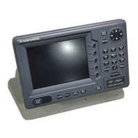
Furuno GP-1650DF Operator's Manual (110 pages)
Furuno GPS Receiver User Manual
Brand:
Furuno
| Category:
Marine GPS System
| Size: 1.33 MB
Table of Contents
Table of Contents
4
Foreword
6
System Configuration
7
1 Operational Overview
9
Display Unit Controls
9
Remote Controller
10
Inserting Mini Chart Card
11
Turning the Power On/Off
11
Adjusting Tone and Brilliance
12
Plotter Displays
12
Sounder Displays
13
Menu Operation, Soft Keys
13
Demonstration Display
14
2 Video Sounder Operation
15
Principle of Operation
15
Sounder Display Description
16
Plotter/Sounder Display
18
Dual-Frequency Display
18
Automatic Sounder Operation
19
Manual Sounder Operation
19
Measuring Depth
20
Suppressing Interference
21
Suppressing Low Level Noise
21
Erasing Weak Echoes
22
White Marker
22
Selecting Picture Advance Speed
23
Selecting Background and Echo Colors
23
Alarms
24
Interpreting the Display
25
3 Plotter Displays
27
Presentation Modes
27
Cursor
28
Shifting the Display
28
Selecting Chart Scale/Range
28
Mini Chart Cards
28
Navigation Data Display
31
Steering Display
32
Highway Display
33
Changing Operation Mode
34
Navigation Trip Distance
34
4 Track
35
Displaying Track
35
Stopping/Restarting Plotting of Track
36
Changing Track Color
36
Track Plotting Method, Interval
36
Changing Track Memory Capacity
37
Erasing All Track
38
5 Mark
39
Entering Marks
39
Changing Mark Attributes
40
Changing Mark Size
41
Erasing Marks
42
Displaying Track and Mark Points
42
6 Waypoints
43
Entering Waypoints
43
Mark Shape
44
Erasing Individual Waypoints
46
Changing Waypoint Data
46
Waypoint Mark Size
47
Changing Waypoint Position on the Plotter Display
47
Searching Waypoints
47
7 Routes
49
Entering Routes
49
Connecting Routes
50
Inserting, Removing Waypoints
50
Removing Waypoints from Routes
51
Creating Track-Based Routes
52
Erasing Routes
53
8 Navigation
55
Navigating to "Quick Points
55
Navigating to Waypoints (Waypoint List)
56
Navigating to Ports, Port Services
56
Following a Route
57
Restarting Navigation
58
Cancelling Navigation
59
9 Plotter Alarms
61
Introduction
61
Audio Alarm On/Off
61
Arrival Alarm
61
Anchor Watch Alarm
62
XTE (Cross Track Error) Alarm
62
Speed Alarm
63
Proximity Alarm
63
Alarm Information
64
10 Saving and Loading Data To/From Memory Card
65
Formatting Memory Cards
65
Saving Data to Memory Card
65
Loading Data from Memory Card
66
11 Customizing Your Unit
69
CHART SETUP OPTIONS Menu
69
DISPLAY OPTIONS Menu
70
GPS/DGPS/TD OPTIONS Menu
73
SOUNDER SETUP OPTIONS Menu
76
CONFIGURATION Menu
78
12 Using C-Map Nt Model
83
Inserting Chart Card
83
Cussor and Data Display
83
Tidal Information
84
Navigation to Ports, Port Service
85
Setting Chart Setup Options
87
Selecting Chart Scale/Ramge
88
Displaying Program Number
89
13 Maintenance & Troubleshooting
91
Maintenance
91
Replacement of Fuse, Battery
92
Simple Troubleshooting
92
Error Messages
93
Diagnostic Tests
94
Clearing Memories
96
Appendix
97
Menu Tree
97
Loran C Chains
100
Decca Chains
101
World Time
102
Geodetic Chart List
103
Specifications
104
Advertisement
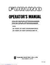
Furuno GP-1650DF Operator's Manual (109 pages)
COLOR DGPS/PLOTTER/SOUNDER; COLOR GPS/PLOTTER/SOUNDER
Brand:
Furuno
| Category:
Marine Equipment
| Size: 1.23 MB
Table of Contents
Table of Contents
4
Foreword
6
System Configuration
7
1 Operational Overview
9
Display Unit Controls
9
Inserting Mini Chart Card
10
Turning the Power On/Off
10
Adjusting Tone and Brilliance
11
Plotter Displays
11
Sounder Displays
12
Menu Operation, Soft Keys
12
Demonstration Display
13
2 Video Sounder Operation
15
Principle of Operation
15
Sounder Display Description
16
Plotter/Sounder Display
18
Dual-Frequency Display
18
Automatic Sounder Operation
19
Manual Sounder Operation
19
Measuring Depth
20
Suppressing Interference
21
Suppressing Low Level Noise
21
Erasing Weak Echoes
22
White Marker
22
Selecting Picture Advance Speed
23
Selecting Background and Echo Colors
23
Alarms
24
Interpreting the Display
25
3 Plotter Displays
27
Presentation Modes
27
Cursor
28
Shifting the Display
28
Selecting Chart Scale/Range
28
Mini Chart Cards
28
Navigation Data Display
31
Steering Display
32
Highway Display
33
Changing Operation Mode
34
Navigation Trip Distance
34
4 Track
35
Displaying Track
35
Stopping/Restarting Plotting of Track
36
Changing Track Color
36
Track Plotting Method, Interval
36
Changing Track Memory Capacity
37
Erasing All Track
38
5 Mark
39
Entering Mark
39
Changing Mark Attributes
40
Changing Mark Size
41
Erasing Marks
42
Displaying Track and Mark Points
42
6 Waypoints
43
Entering Waypoints
43
Mark Shape
44
Erasing Individual Waypoints
46
Changing Waypoint Data
46
Waypoint Mark Size
47
Changing Waypoint Position on the Plotter Display
47
Searching Waypoints
47
7 Routes
49
Entering Routes
49
Connecting Routes
50
Inserting, Removing Waypoints
50
Removing Waypoints from Routes
51
Creating Track-Based Routes
52
Erasing Routes
53
8 Navigation
55
Navigating to "Quick Points
55
Navigating to Waypoints (Waypoint List)
56
Navigating to Ports, Port Services
56
Following a Route
57
Cancelling Navigation
59
9 Plotter Alarms
61
Introduction
61
Audio Alarm On/Off
61
Arrival Alarm
61
Anchor Watch Alarm
62
XTE (Cross Track Error) Alarm
62
Speed Alarm
63
Proximity Alarm
63
Alarm Information
64
10 Saving and Loading Data To/From Memory Card
65
Formatting Memory Cards
65
Saving Data to Memory Card
65
Loading Data from Memory Card
66
11 Customizing Your Unit
69
CHART SETUP OPTIONS Menu
69
DISPLAY OPTIONS Menu
70
GPS/DGPS/TD OPTIONS Menu
73
SOUNDER SETUP OPTIONS Menu
76
CONFIGURATION Menu
78
12 Using C-Map Nt Model
83
Inserting Chart Card
83
Cussor and Data Display
83
Tidal Information
84
Setting Chart Setup Options
87
Selecting Chart Scale/Range
88
Displaying Program Number
89
13 Maintenance & Troubleshooting
91
Maintenance
91
Replacement of Fuse, Battery
92
Simple Troubleshooting
92
Error Messages
93
Diagnostic Tests
94
Clearing Memories
96
Appendix
97
Menu Tree
97
Loran C Chains
100
Decca Chains
101
World Time
102
Geodetic Chart List
103
Specifications
104
Furuno GP-1650DF Installation Manual (62 pages)
COLOR GPS/PLOTTER/SOUNDER
Brand:
Furuno
| Category:
Marine Equipment
| Size: 1.91 MB
Table of Contents
Table of Contents
1
System Configuration
4
Equipment Lists
5
Installation of Standard Equipment
7
Installation of Display Unit
7
Installation of Antenna Unit (GP-1650DF Only)
9
Installation of Transducers
10
Installation of Sensors
20
Wiring
23
Initial Settings
28
NMEA Setting
28
Output Data Sentences
30
Antenna Height
31
Baud Rate Setting (GP-1650DF Only)
32
Beacon Frequency Setting (GP-1650DF Only)
33
Depth Adjustment
34
External Equipment Setup (Option)
35
Installation of DGPS Beacon Receiver (for GP-1650F)
38
Appendix Triducer 525St-Pwc/Pwd
47
Advertisement
Advertisement
Related Products
Furuno GP1650 Series
Furuno GP-1650D
Furuno GP-1650WDF
Furuno GP-1650WF
Furuno GP-1600F
Furuno GP-1650F
Furuno GP-1650W
Furuno GP-1650WD
Furuno GP-1610CF
Furuno GP-1640F
Furuno Categories
Marine Radar
Marine Equipment
Sonar
Monitor
GPS
More Furuno Manuals
Login
Sign In
OR
Sign in with Facebook
Sign in with Google
Upload manual
Upload from disk
Upload from URL