
Related Manuals for Locosys GT-31


Summary of Contents for Locosys GT-31
- Page 1 ’ ’...
-
Page 2: Welcome
To fully containing understand all the features and functions, please take time to read through Owner’s Manual, Drivers, this manual before using your GT-31. Some useful tips are also included and Utilities in this manual. We hope GT-31 will enhance your enjoyment of outdoor activities. -
Page 3: Warnings And Cautions
Warning and Cautions Taking your eyes off the road can cause accidents and serious damage or personal injury. Do not operate GT-31 while driving or riding. Come to a complete stop or have your passenger make any changes. Do not secure... -
Page 4: Table Of Contents
Table of Contents Welcome Memory Card Warnings and Cautions Data Logger Treasure your Table of Contents Alert Introduction NAVILINK GT-31 GPS the Controls Settings same way treasure Power/ESC Button Miscellanies your sailboat Thumb Stick Operation How to. Hold Key Track back to where you came from... -
Page 5: Introduction
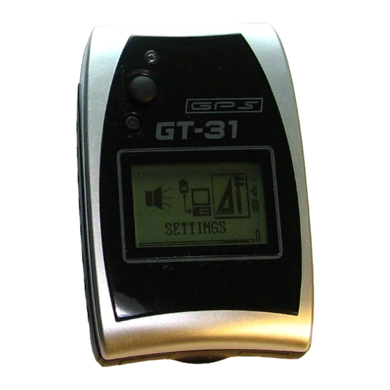
Introduction GT-31 is a wonderfully compact, business card sized navigator, carefully designed to embody ergonomic principles. It will comfortably fit in the palm of your hand, mount on the handlebar of bike or motorcycle, and can even be worn on your arm. The stylish unit can stand on your desk as a funky gadget, or, more usefully, can be placed on the dashboard in your car. - Page 6 Introduction (continued) FRONT BACK Built-in Strap Hole Antenna Internal Buzzer Mounting Screw Holes Thumb Stick Built-in Rechargeable Battery Power/ESC BOTTOM Button Waterproof compartment USB Slot SD/MMC Card Slot...
-
Page 7: Controls
Controls POWER/ESC BUTTON Press this button and hold to Power ON or Power OFF When power is turned on this button functions the same as ESC. Press to escape the current page Under any Main Pages, it is also used as a toggle key to turn on/off LCM backlight if [SETTINGS]/[BACKLIGHT] is set to ON and [SETTINGS] \[BACKLIGHT TIME] is set to OFF. -
Page 8: Before Getting Started
Before Getting Started GT-31 is designed for easy operation. If this is your first time to own a GPS navigator, just follow the instructions in the following pages and you will quickly get familiar with this unit. Before Use 1) Charge the battery. It takes around 4 hours for the 5) Mark and edit waypoints, and create a route built-in battery to be fully charged. -
Page 9: Status Indicators
Status Indicators Position fix and Bluetooth Indicators Positioning with 3D Bluetooth on fix(highlighted for DGPS fix) Positioning with Bluetooth connected Available only on Acquiring signal BGT31 Audio Indicators Disabled Enabled Battery&Key Lock Indicators Full Battery Key Locked Memory card Indicators: card access in progress. -
Page 10: Page System Tree
Page System Tree Sat Signal Trip Meter Speed Navigation Track Position Mark Sat signal Odometer Speed Speed Egg Laying Edit and Save Sky View Total Time MAX Speed Mark Fixed Info Trip MAX Speed Nsecond MAX AVG Speed Interval STOP Trip AVG Speed MAX Speed Distance... - Page 11 Page System Tree (continued) Memory Waypoint Route Data Alert NAVILINK Card Logger Down/Upload List List Log Switch Buzzer the data saved Go To Go To Off/On/On-Fix On/Off Interval on the built-in Delete Edit Min Speed Over Speed Alert Min Speed flash memory Edit Delete...
- Page 12 Page System Tree (continued) Settings MISC Language NAVILINK Port* Calendar Time Zone Speed AVG Time Reserved Unit (of Measurement) Speed Genie Time Format Hold Key Date Format Serial No. Time Zone Version Arrived Cold Start Map Datum Position (Format) User Grid Power Mode DGPS Source Interface...
-
Page 13: Main Menu
Main Menu Page Tree Satellite Signal Satellite signal Provides the Showing&managing Navigating along The current and Trip Meter and position fix information on instant, average & your waypoints or historical direction Speed info your movement maximum speeds routes of movement Navigation (Speed Genie) Track... -
Page 14: Satellite Signal
Satellite Signal Page Tree Sat Signal Sky View Fixed Info SKY View GPS Fixed Info GPS Signal Satellite position. The two Time in UTC Satellite signal circles indicate satellite Date in UTC, strength bars. elevation as seen from Heading A hollow signal your current position Velocity, Altitude bar indicates the... -
Page 15: Trip Meter
Trip Meter The Trip Meter pages provide Current Speed, Trip Timer, Average Speed, ODO Meter, Page Tree and more. All the meter pages have a similar format below. Odometer Total Time Status Indicators Trip MAX Speed Speed Trend Trip AVG Speed 2D or 3D fixed Trip Time Current speed... - Page 16 Trip Meter (continued) Total accumulated Current altitude Page Tree operating time since in big font last reset Odometer Total Time Maximum speed Current local during the trip since Time in big font Trip MAX Speed last trip reset Trip AVG Speed Trip Time Trip Odometer Average speed during...
-
Page 17: Speed
Page Tree threshold is set and the current speed is above it. Then if the current speed goes below the threshold, GT-31 will switch to [MAX/NS MAX] page to report the result. Refer to how to active speed genie for details. - Page 18 Speed (continued) Display the current average speed for N-second (10S) time interval. Page Tree The time interval can be specified in [SETTINGS]/[SPEED AVG TIME] The value of [NS MAX AVG] page is the maximum value of Speed [NS AVG SPEED] MAX Speed NS MAX AVG NS AVG Speed...
-
Page 19: Navigation
Navigation The navigation pages provide the direction you are moving, Navigation features will be Page Tree current time, speed, altitude and other trip computer information. activated only when a route or waypoint has been Distance to next Speed Waypoint type Next waypoint selected for navigation. - Page 20 Navigation (continued) Page Tree Speed Velocity Made The average peed of The maximum The direction you AVG Speed Good (VMG) this navigation trip speed of this trip are traveling MAX Speed Heading Bearing ODO Meter Time Pass Altitude Total time elapsed Current altitude The direction of Accumulated...
- Page 21 Navigation (continued) Name of destination The sunset time at Page Tree waypoint the current location Distance to destination Speed AVG Speed MAX Speed Heading The sunrise time at Bearing the current location ODO Meter Time Pass Altitude At any pages under Navigation, you may press in the TS to select the larger compass display. Departure Arrival Current speed...
-
Page 22: Track
Track The track data is logged on the built-in flash memory. Track pages provide two types of movement information: Up to 8192 points can be logged The active movement of the trip (Egg Laying page) To log the track data, you first need to set The historical movement of the trip (View page) the Interval. - Page 23 Track (Egg Laying) Page Tree Under Track page, when press in the TS, under Track page, the screen will show the current movement with an egg laying drawing. The Current Speed, Waypoint Name, Egg Laying and Waypoint Symbol can be selected to display or not to display under Setting page. Mark Interval STOP...
- Page 24 Track (continued) Page Tree While the TS is pressed in, the Egg Laying current location will be marked as Mark a waypoint. Interval Refer to Position Mark page for STOP further details. Distance 1 Second 5 Seconds 10 Seconds To set the log frequency 30 Seconds It can be set to log from 1, 5, 10, 30 1 Minute...
- Page 25 Track (continued) Page Tree View: When View page is selected, it will show the detail of the tracked information: Egg Laying Mark Note: While View Page is selected, the system will stop the track logging. Interval STOP North Up pointer Compact In View mode, it 1 Second...
- Page 26 Track (continued) Page Tree Pressing in the TS will mark the track Egg Laying point you have selected. The marked Mark point will be automatically assigned a Interval numerical waypoint name. You may STOP edit it with new name and new type. Compact 1 Second While GO TO is selected, the page will...
- Page 27 Track (continued) Page Tree Egg Laying The page will show the nearest track point Mark logged to current position. Interval Any one of the track points can be marked as Compact a waypoint by pressing in the TS. STOP 1 Second 5 Seconds 10 Seconds Pressing in the TS, the page will show...
-
Page 28: Position Mark
Position Mark Description You may mark the current location as a waypoint and then edit it for future reference. dghj Pressing in the TS, the page will show the detail of current location, and automatically generate a waypoint name in numerical order. -
Page 29: Waypoint
Waypoint Description Waypoint is the basic element of navigation. You will need to either mark a position of interest, or edit a known location as a waypoint to activate the Navigation function. The location information in the Waypoint is described below. The coordinate format of waypoint can be specified in [SETTINGS]/[POSITION] Waypoint type Waypoint name... - Page 30 Waypoint (continued) Page Tree Description All the waypoints in database can be displayed by name in alphabetical order (LIST) or List by types (TYPE LIST). Then you may select GO TO, Delete, Edit or Copy. Or, you Go To Delete can delete all the waypoints in the database.
- Page 31 Waypoint (continued) GO TO Page Tree Select the waypoint to navigate Highlight the waypoint you want to List navigate to. Go To Press in the TS, the page will jump Delete to Navigation page automatically. Edit Copy Project EDIT You can change the waypoint type, Type List name, coordinates, and distance: Go To...
- Page 32 In use Yes or No Contact your local stores. There are several available specifically Save to Card designed for day-trippers and backpackers, and… - Carry a GT-31 with you -...
-
Page 33: Route
Route Page Tree When selected, the page will display all the routes in the database, and, List The total number of waypoints in each route. Go To A total of 20 routes can Edit be created. Delete Up to 13 alphabetical Copy characters can be used Reverse... - Page 34 Route (continued) Page Tree Scroll with the TS to highlight the route and press in. The page will show related List features for this route. Go To Press in the TS, the page will Edit jump to Navigation and navigate Delete to the first waypoint in that route.
- Page 35 Route (continued) Select the waypoint you Page Tree Continued from wish to insert and press in to confirm the selection. previous page List All Go To Delete Press in the TS to delete the waypoint from the route Edit Copy Reverse (track back)
-
Page 36: Memory Card
Set the minimum speed threshold value from 0 to 50 The speed unit is specified in [SETTINGS]/[UINT] GT-31 will only log points to memory with speed above this value The minimum speed valid only if [LOG SWITCH] set to ON-FIX. - Page 37 Memory Card (continued) GGA is being set to Page Tree log at 1-second rate. GLL is being set not Log Switch to log. Min Speed NMEA Items File Size When the card is Highlighted items are being activated. correctly inserted SBN format is mutually exclusive with other NMEA items.
- Page 38 Select proper size to log the track data. Page Tree File sizes can be set:128,512,1024,2048KB or card size When CARD SIZE is selected, GT-31 stores the data on the Log Switch card continuously until the card memory is full. Min Speed...
-
Page 39: Data Logger
“0” will disable data logger. Interval Min Speed GT-31 has a built-in data logger up to 20480 points. You can either save the Save to Card logged data into SD cards or use NAVILINK Utility to download it to a host PC. -
Page 40: Alert
Alert Page Tree Description Buzzer GT-31 generates audio and visual signals through a On/Off Buzzer and red LED. These signals can be used to Over Speed provide Over Speed, Altitude or other alerts defined On/Off by the user. Speed Setting... - Page 41 Right to select altitude for the alert On/Off Below or Above The range is from 0M to 15240M. Above/Below alerts GT-31 will automatically alert you when Altitude Setting above or below the selected altitude. Target On/Off Waypoint type Setting...
-
Page 42: Navilink
NAVILINK NAVILINK provides the connection between the unit and the host PC/Notebook to download or upload the data. For firmware update please check [SETTINGS] page. Download data includes: Waypoints, Routes, track points and data logger (SBP data) stored on the built-in flash memory. Upload data includes: Way points, Routes and track Before downloading or uploading, make sure the driver for USB has been successfully installed on your host PC/Notebook. -
Page 43: Settings
Settings Multiple languages are supported. However, due to the limited display space, some terms Page Tree are in shortened format. Please check this Language manual for clear definition. Time Zone This item supports LEFT/RIGHT key for value change Unit The current value for the highlighted item is shown here Time Format Date Format Select the time zone you are in. - Page 44 Settings (continued) Available Date formats: Page Tree Date-Month-Year Language Month-Date-Year, Time Zone Year-Month-Date Unit Time Format Date Format Set the distance to indicate the arrival at destination waypoint in Arrived 10 meters or up to 400 meters Map Datum Position Format User Grid Power Mode The GT31 navigation function relies on the value of...
- Page 45 Settings (continued) The default map datum setting is WGS-84. Page Tree There are over 180 map data that can be Language selected in the database. Refer to Map Datum Time Zone List. Unit You may define your own map datum in the Time Format USER GRID page.
- Page 46 Settings (continued) To select normal or low power mode It is recommended to use LOW POWER mode in a Page Tree clear sky view environment. Language Time Zone Unit To enabled or disabled SBAS. Time Format It is recommended to enable SBAS only in the area Date Format coved by SBAS DGPS feature will be disabled...
- Page 47 Settings (continued) Set the timer for the backlight. OFF – backlight timer disabled. Page Tree 10 Seconds – turned off automatically after 10 seconds. Language 30 seconds – turned off automatically after 30 seconds. Time Zone 1 Minute – turned off automatically after 1 minute. Unit Time Format Date Format...
- Page 48 Settings (continued) Bluetooth Sniff mode reduces power consumption. It is recommended to always turn on this mode. However some Bluetooth hosts do not support it Page Tree and may cause the communication failure. In such case, please turn off sniff …...
- Page 49 Settings (continued) BGT31 supports Navilink port selection. Page Tree GT31 can only USB port for NAVILINK … DGPS Source Interface Backlight SPEED AVG TIME defines the time interval for speed averaging. The Backlight Time available interval is from 1 to 60 seconds [SPEED] page calculates Contrast maximum average speed based this value.
- Page 50 Settings (continued) The product serial number Page Tree … DGPS Source Interface Backlight Backlight Time The version number of firmware. Press TS and select [YES] to start firmware Contrast update. USB cable must be connected in External Power advance. Bluetooth Refer to “How to update firmware”...
-
Page 51: Miscellanies
Miscellanies Description Operation Move the Thumb Stick up or down to select the year This page provides a 120-year calendar for Move the Thumb Stick right or left to select the the date information from the year of 1940 to month 2060 Press in the Thumb Stick to show the date of today... -
Page 52: Track Back To Where You Came From
How To: Track Back to Where You Came from To return to the point where you started the trip: View the logged data under the Track page Select the first point where you started the trip Press in the TS to display the table Select Go To and press in the TS The page will jump to Navigation and guide you the way to go back home. - Page 53 How To: Track Back to Where You Came from (continued) In addition to using saved waypoints or routes to navigate back where you came from, you may either search the waypoint under Waypoint page, then select GO TO, or execute the Reverse function to reverse the order of the waypoints in that route, then select GO TO to navigate back the same route you came on: For Example: If you started from a Gas Station (Waypoint 006), and came here following the Route NAVIGPS01, now you want go back to Gas Station:...
-
Page 54: Calculate The Area
How To: Calculate the Area (Area Calculation) Area Calculation is a useful feature when you wish to measure an area. There are two pages ROUTE or TRACK in which you may have the access to this feature: ROUTE Page TRACK Page It calculates the area based It calculates the area based on the track logged. -
Page 55: Activate Speed Genie
How to: Activate Speed Genie GT-31 can anticipate what you want to see on the screen during Speed Sailing or other speed-based sport. This function is called SPEED GENIE. SPEED GENIE automatically changes SPEED screens shown on the right and resets MAX and AVG speeds at the best possible time. - Page 56 10s. If you aim for a 500m World Sailing Speed Record, set it to 21 seconds. Enter the SPEED page in GT-31 main menu. Once your settings 1&2 above are in place this is the only thing to do to activate SPEED GENIE SPEED GENIE is only active in the SPEED page of GT-31.
-
Page 57: Download And Upload Data
How To: Download and Upload Data The data stored on the internal flash memory, including the routes, waypoints, track data and logger data can be • Saved to SD card and then read on PC/notebook directly from the SD card •... - Page 58 How To: Download and Upload Data (continued) To Download Navigation Data to a host PC Step 1: Select “COM Port” Step 2: Change the default folder if needed Step3: Select “Navi.Data” command page Step 4: Select the desired data items Step 5: Click [Read] button to start downloading data.
- Page 59 How To: Download and Upload Data (continued) To Upload Navigation Data from a host PC to GT-31 Step 1: Select “COM Port” Step 2: Select the data items to be uploaded Step 3: Click [Write] command and select the file (refer to NAVILINK file naming) to start uploading data.
- Page 60 How To: Download and Upload Data (continued) To Delete Navigation Data in GT-31 Step 1: Select “COM Port” Step 2: Select the data items to be deleted Step 3: Click [Delete] to start deleting data NOTE: Waypoints cannot be deleted if waypoints are referenced by routes.
- Page 61 How To: Download and Upload Data (continued) To Download Logger Data(SBP) in GT-31 Step 1: Select “COM Port” Step 2: Change default folder if needed. Step 3: Select “Log.Data” command page. Click [Read] to start downloading logger data. The downloaded data is saved as SBP file and can be converted to plt,gpx,kml,nmea files.
- Page 62 How To: Download and Upload Data (continued) NAVILINK File Naming The file names are composed of device serial number and proper file extension. The file extensions include: wpt - Oziexplorer Waypoint rte - Oziexplorer Route plt - Oziexplorer Track plt.nmea - Track in NMEA format spd - history speeds file sbp - binary packet binary data file (for DATA LOGGER) sbn - binary data file (for MEMORY CARD)
-
Page 63: Update Firmware
How To: Update the Firmware Follow the steps described below to update your GT-31 firmware. Make sure that the USB driver has been installed on your PC/Notebook. Connect the USB cable between the unit and PC/Notebook. Power on the GT-31. -
Page 64: Map Datum List
Map Datum List Abbrev Description ADINDA Adindan-MEAN FOR Ethiopia, Sudan ADINDB Adindan-Burkina Faso ADINDC Adindan-Cameroon ADINDD Adindan-Ethiopia ADINDE Adindan-Mali ADINDF Adindan-Senegal ADINDG Adindan-Sudan AFGY Afgooye-Somalia AIN70 Ain el Abd 1970-Bahrain AINSA Ain el Abd 1970-Saudi Arabia ANA65 Anna 1 Astro 1965-Cocos Islands ANT43 Antigua Island Astro 1943 Antigua (Leeward Islands) ARC50A... - Page 65 ASC58 Ascension Island 1958 Ascension Island ASC45 Astro Beacon E 1945-Iwo Jima ASTHI Astro DOS 71/4-St Helena Island AST61 Astro Tern Island (FRIG) 1961 Tern Island AST52 Astronomical Station 1952 Marcus Island AUST66 Australian Geodetic 1966 Australia & Tasmania AUST84 Australian Geodetic 1984 Australia &...
- Page 66 European 1950 MEAN FOR Austria, Belgium, Denmark, Finland, France, West Germany, Gibraltar, Eur50 Greece, Italy, Luxembourg, Netherlands, Norway, Portugal, Spain, Sweden, Switzer-land EUR-A European 1950 MEAN FOR Austria, Denmark, France, West Germany, Netherlands, Switzerland EUR-B European 1950 MEAN FOR Iraq, Israel, Jordan, Lebanon, Kuwait, Saudi Arabia, Syria EUR-C European 1950 - Cyprus EUR-D...
- Page 67 INDIAB Indian - Bangladesh INDIAN Indian - India, Nepal IND54 Indian 1954 - Thailand Vietnam IND75 Indian 1975 - Thailand IRE65 Ireland 1965 - Ireland ISTS68 ISTS 061 Astro 1968 South Georgia Islands ISTS69 ISTS 073 Astro 1969 - Diego Garcia JI61 Johnston Island 1961 - Johnston Island KANDA...
- Page 68 NAHWB Nahrwan - Saudi Arabia NAHWC Nahrwan - United Arab Emirates NAPAR Naparima BWI - Trinidad & Tobago North American 1927 MEAN for antigua, Barbados, Barbuda, Caicos Islands, Cuba, Dominican Republic, NAD27A Grand Cayman, Jamaica, Turks Islands NAD27B North American 1927 MEAN for Belize, Costa Rica, El Salvador, Guatemala, Honduras, Nicaragua NAD27C North American 1927 MEAN FOR Canada NAD27D...
- Page 69 HAWAME Old Hawaiian MEAN FOR Hawaii, Kauai, Maui, Oahu HAWAI Old Hawaiian Hawaii KAUAI Old Hawaiian Kauai MAUI Old Hawaiian Maui OAHU Old Hawaiian Oahu OMAN Oman - Oman OS36 Ord. Survey Great Britain 1936 MEAN FOR England, Isle of Man, Scotland, Shetland Islands, Wales OS36B Ord.
- Page 70 PRV63 Provisional South Chilean 1963 Chile (South, Near 53South) (Hito XVIII) PUERT Puerto Rico Puerto Rico, Virgin Islands QATAR Qatar National – Qatar QORNO Qornoq - Greenland (South) REUNI Reunion - Mascarene Islands ROME40 Rome 1940 - Italy (Sardinia) SANTO65 Santo (DOS) 1965 Espirito Santo Island SAOBRZ Sao Braz Azores (Sao Miguel, Santa Maria Islands)
- Page 71 SASIN South Asia - Singapore TAN25 Tananarive Observatory 1925 Madagascar TIMBA48 Timbalai 1948 Brunei, East Malaysia (Sabah, Sarawak) TOKTO Tokyo - MEAN FOR Japan, Korea, Okinawa TKYJP Tokyo - Japan TKYKR Tokyo - Korea TKYOK Tokyo - Okinawa TRST68 Tristan Astro 1968 - Tristan da Cunha VITIL6 Viti Levu 1916 Fiji (Viti Levu Island) WAKE60...
-
Page 72: Water Immersion
Water Immersion The GT31/BGT31 is designed to comply with IEC standard 60529 IPX7, which means that it can withstand immersion in 1 meter of water for 30 minutes. Submersion for more than 30 minutes and/or subjecting the unit to (dynamic) pressures higher than 1m of water may cause water entering and damaging the unit. -
Page 73: Warranty And Repair
Warranty and Repair WARRANTY LOCOSYS warrants this product to be free from defect in material and workmanship for 12 months from the date of purchase. This warranty does not cover the damage due to the shipping of the product, external causes, including... - Page 74 LOCOSYS will repair the defective products covered under this limited warranty, if they are returned to LOCOSYS. If the product does prove defective, it will be repaired at no charge during the warranty period and at normal repair charge rates when out of the warranty.
- Page 75 Authorized Dealer Revision History Part Number Revision Date Note Document Number:...