HP 914c - iPAQ Business Messenger Smartphone Navigation Manual
Ipaq 614 series business navigator and hp ipaq 914 series business messenger
Hide thumbs
Also See for 914c - iPAQ Business Messenger Smartphone:
- Overview (10 pages) ,
- Product manual (163 pages) ,
- Navigation manual (122 pages)

Related Manuals for HP 914c - iPAQ Business Messenger Smartphone


Summary of Contents for HP 914c - iPAQ Business Messenger Smartphone
- Page 1 HP iPAQ Trip Guide For HP iPAQ 614 Series Business Navigator and HP iPAQ 914 Series Business Messenger...
- Page 2 © Norwegian Mapping Authority, Public Roads Administration / Norway: Mapsolutions Switzerland: © Swisstopo Topografische ondergrond Netherlands: Copyright © dienst voor het kadaster en de openbare registers, Apeldorn All rights reserved. © 2007, 2008 Hewlett-Packard Development Company, L.P. First Edition May 2008: 499191-031...
- Page 3 Thank you for choosing HP iPAQ Trip Guide as your door-to-door in-car navigator. Read the Quick Start Guide first and start using HP iPAQ Trip Guide right away. This document is the detailed description of the software. Although HP iPAQ Trip Guide can easily be discovered by experience, it is still recommended that you read through this manual to clearly understand the exact function of each button and icon.
-
Page 4: Table Of Contents
Table of Contents Warnings and safety information ................ 9 General information ..................10 Operating HP iPAQ Trip Guide (Controls) ............12 Hardware buttons ..................12 Tilt up and down ..................15 Zoom in and out..................15 Rotate left and right..................15 Voice instruction announcement.............. - Page 5 Contacts ..................... 33 Elements of the Active Route ................34 The start point, via points and the destination..........34 Animated turn guidance................. 34 The active leg of the route ..............34 Inactive legs of the route ................ 35 Roads in the route excluded by your preferences ........35 GPS Data screen ..................
- Page 6 3D Map (switch) ................... 56 Zoom & Tilt (switch) ................57 Night Mode (switch) ................57 Manage POI (Points of Interest) ............... 58 Popup Information (switch)..............61 Manage Track Logs ................62 Route tab....................65 Recalculate................... 65 Delete....................66 Itinerary ....................67 Fly Over....................
- Page 7 Master sound volume/switch................. 84 Voice guidance volume/switch..............84 Key sound volume/switch ................84 Dynamic Volume ..................85 Attention Tone ..................... 85 Route parameter settings................85 Method ...................... 86 Route ......................86 Short ....................86 Fast ..................... 86 Economical ..................87 Vehicle.......................
- Page 8 Keep position on road (Lock-on-Road) ............99 User data management ................99 Backup Data..................99 Restore Data..................100 Remove Pins ..................100 Clear Data ..................100 Reset Advanced Settings ..............100 Startup & minimised ................... 101 Autorun Enabled ................. 101 Today screen entry ................
-
Page 9: Warnings And Safety Information
Warnings and safety information HP iPAQ Trip Guide is a navigation system that helps you find your way to your selected destination. It will determine your exact location with the help of an connected GPS device. The position information obtained from the GPS receiver will not be transmitted anywhere, so others will not be able to track you by the help of this program. -
Page 10: General Information
General information HP iPAQ Trip Guide is a navigation system optimised for in-car use. It provides door- to-door navigation for both single and multi-point routes using adaptable route parameters. HP iPAQ Trip Guide is capable of planning routes throughout the whole installed map set. - Page 11 handed landscape). All HP iPAQ Trip Guide screens will look different in the different orientation modes. Furthermore, HP iPAQ Trip Guide is able to run on PDAs with square display (240 by 240 pixels resolutions), using modified screen content. The program automatically adjusts itself to the square screen mode, you do not need to set anything.
-
Page 12: Operating Hp Ipaq Trip Guide (Controls)
Operating HP iPAQ Trip Guide (Controls) HP iPAQ Trip Guide is designed for easy operation. All controls are operable by fingertips. Wherever possible, pushbuttons and lists are provided to make accessing functions or changing settings as easy as possible. Hardware buttons Hardware buttons are mostly used on map screens to zoom, tilt and rotate the map, or to open other screens. - Page 13 No. Function Screen tap equivalent Mutes the device (including voice guidance) Master slider in the Sound settings screen Closes HP iPAQ Trip Guide Exit button in the Main menu Scroll the wheel up or down to move the map Tap and hold the map, and move your finger in view or to change selection in lists.
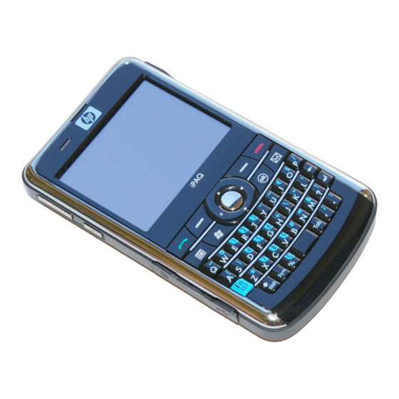
- Page 14 HP IPAQ 910 Business Messenger No. Function Screen tap equivalent Adjusts volume up and down Master slider in the Sound settings screen On the Map or Cockpit screen, tap Menu, then Opens the Main menu Main. Zooms in on maps Zoom in button if ’Zoom &...
-
Page 15: Tilt Up And Down
Tilt up and down Map tilting modifies the vertical view angle of the map in 3D mode. This function is explained in detail here: Page 42. Note : The Tilt down button has a special function when starting Fly Over (Page 69), the route simulation. -
Page 16: Voice Instruction Announcement
Voice instruction announcement Press the Enter button for this function. When navigating on the Cockpit screen, you can repeat the latest voice instruction by pushing this button. : Use this button any time during your journey if you need the distance and type of the next route event. -
Page 17: Sticking A Pin Into The Map
view of the map, or to save a POI. The Cockpit screen can come in handy if you wish to quickly check the name of the street you are on. This button will let you toggle between the two screens. Alternatively, you can return to the Main menu, and select the other screen from there. -
Page 18: List Selectors
List selectors When the values in the list need to be named, only the current value is shown (sometimes together with a short description) in a horizontal stripe with arrows at both ends. The arrows are buttons. Tap to move left in the list or tap to move right. -
Page 19: Switches In The Quick Menu
When the lamp is dark , the function is not selected. When it is lit , the function is enabled. The whole strip works as a button. Tap anywhere to toggle between the enabled and disabled status. Switches in the Quick menu The switches of the Quick menu (Page 56) behave as normal switches but they look different in order to fit in with the other menu buttons. -
Page 20: Abc-Type Keyboards
will search for all their combinations in the database (e.g. for the French street ‘Cité Bergère’ you only need to type ‘Cite Bergere’, and the rest is done by the program). When you type in POI or track log names, HP iPAQ Trip Guide will automatically turn all initials into capitals to create names that look pleasant. -
Page 21: Qwerty-Type Keyboards
QWERTY-type keyboards QWERTY-type keyboards have both letters and numbers on them. Their layout is the same as of the standard QWERTY, QWERTZ (German) and AZERTY (French) keyboards. To switch to your desired QWERTY-type keyboard, press the Keys button repeatedly until the appropriate keyboard appears. The special keys described in the previous section are also available here. -
Page 22: Discovering The Program Through The Screens
Discovering the program through the screens The best way to discover HP iPAQ Trip Guide is to explore each screen in detail, and to find out how to move from one to another. Read this chapter for a guided tour. Main menu HP iPAQ Trip Guide starts by displaying the Main menu. -
Page 23: About Screen
Content Button to open Settings Button that displays GPS Status and opens the GPS Data screen Button to minimise HP iPAQ Trip Guide (navigation will not stop*) Current position Current date and time Button to open Map screen Button to open About screen Button to exit HP iPAQ Trip Guide** (navigation stops) * Depends on program settings ** Same as removing the SD card... -
Page 24: 2D And 3D Map Views
and in possible controls but are optimised for different uses. The map they display is common. The elements of the map are described here. For the controls and special functions of the two map screens see Page 38. The current version of HP iPAQ Trip Guide is primarily intended for land navigation. That is why maps in HP iPAQ Trip Guide look similar to paper roadmaps (when using daytime colours and 2D map mode). -
Page 25: Zoom Levels
Note: Using the Advanced settings, you can force Cockpit mode to always start in 3D Track-up view (Page 91). You can still rotate and tilt the maps in either mode, but the next time you enter this screen, the preset look will reappear. Similarly you can force Map mode to always start in 2D North-up view. -
Page 26: Daylight And Night Colour Schemes
the next junction. If the next turn is at a distance, it will zoom out and lower the view angle to flat in order to let you see the road in front of you. Daylight and night colour schemes The different colour schemes let you adjust HP iPAQ Trip Guide to the brightness of the environment. -
Page 27: Streets And Roads
Note: The colours mentioned and screenshots included in this manual refer to the default daytime and night colour schemes. They may not look the same in the schemes you have chosen. : If you use HP iPAQ Trip Guide after sunrise or before sunset, look for the sun in the sky in the map background using a flat 3D view. -
Page 28: Other Objects
You need not choose between the two modes. HP iPAQ Trip Guide will use the one best for the current tilt and zoom level. Zoom in to have only a few streets on the map, and start tilting up and down to see how HP iPAQ Trip Guide switches between the two modes in an instant. -
Page 29: Current Position And Lock-On-Road
Current position and Lock-on-Road When your GPS position is available, a blue arrow (yellow when using night colours) shows your location on the map. The direction of the arrow represents your heading. The arrow is sized and vertically rotated with the zoom and tilt levels to always look realistic. HP iPAQ Trip Guide has a built-in Lock-on-Road feature that always puts the position arrow on the road, on the axis of the street in case of one-way streets, or on the side of the road where you drive (e.g. -
Page 30: Selected Map Point, Also Known As The Cursor
Note: The Lock-on-Road feature can be turned off in Advanced settings (Page for pedestrian use. When switched off, the arrow is displayed at the position reported by the GPS receiver. When the GPS position is lost, the arrow turns grey, but the journey continues on the recommended route for a short period of time with the speed last detected before the GPS position was lost. -
Page 31: Marked Map Points (Pin)
Marked map points (Pin) The Cursor can be marked with a Pin. Pins are shown as being stuck in the map. A Pin is visible at all zoom levels and remains in its position until you unpin it, or delete all Pins in Advanced settings (Page 90) The colour of the Pin is automatically selected by HP iPAQ Trip Guide. - Page 32 These icons are large enough to recognise the symbol, and semi-transparent so as not to cover the streets and junctions behind them. When the map is zoomed out, the icons are not shown. As you zoom in, small dots appear at the locations of visible POIs. Zooming in further makes the full icons appear. If two points are too close to each other so that icons overlap, a multi-POI icon shown instead of individual ones.
-
Page 33: Road Safety Cameras
Road safety cameras Road safety cameras, such as speed cameras and red light cameras are special POI types in HP iPAQ Trip Guide. They are described in detail here: Page 71 Contacts A different type of special POIs are Contacts. When HP iPAQ Trip Guide is started, it will attempt to recognise the addresses in your Pockt PC’s Contact database. -
Page 34: Elements Of The Active Route
performance of the application may be experienced, and not all addresses will be found in the My POI / Contacts group at once. From next time only new entries and modifications will be imported. This will be much faster, and previously existing contacts will be available immediately. -
Page 35: Inactive Legs Of The Route
The line of the route is displayed on the driving side of the road for two-way and on the axis in case of one-way streets. When the map is zoomed in and the line is wide enough, small arrows show the direction of the route. This can be useful if you preview the route before starting the journey or when entering a complex junction. -
Page 36: Gps Data Screen
If so, HP iPAQ Trip Guide will display those segments of the route with an alternate colour. GPS Data screen Tap the small satellite dish icon on the Main menu, Map or Cockpit screen to open this window. The GPS Data screen is a collection of information received from the GPS device and it also serves as the entry point to the following screens: •... -
Page 37: Gps Connection Indicator
current location. On the right you can see the satellite signal strength bars. Grey bars are for the grey and black bars are for the green satellites. To identify satellites use their numbers also shown in the virtual sky. The more satellites your GPS tracks (the green ones), the better your calculated position will be. -
Page 38: Time Synchronization
connection is still established without any user action but the repeated attempts will not run the battery down. Time synchronization In the top right corner of the screen you have another button that leads to a new screen where you can synchronize the clock of your PDA to the very accurate time provided by the connected GPS. - Page 39 The Map screen is to be used mainly without a GPS, to browse the map, create user POI items, or to plan your route based on map points. The Map screen is designed to give you the maximum map area. This screen is usually used in 2D North-up mode. You can set HP iPAQ Trip Guide so it always opens the Map screen in 2D North-up mode (Page 92).
- Page 40 Display Control (Cockpit only) Turn preview* Opens Route menu* Zooms in (optional) Zooms out (optional) Tilts down (optional) Tilts up (optional) Indicates that Lock to GPS position and Re-enables Lock-to-Position / Smart Zoom heading is inactive Selected map point (Cursor) Opens Popup Info and Cursor menu (Map only) Map scale Zooms in/out by dragging...
-
Page 41: Turn Preview (No. 1)
Turn preview (No. 1) On the Cockpit screen this field shows a graphic illustration of the next manoeuvre. For example when you approach a turn, an arrow will show whether it is a slight, normal or sharp turn. When showing a roundabout, the number of the exit is also given in the picture. -
Page 42: Tilt Up And Down (No. 4 & 5)
Tilt up and down (No. 4 & 5) These semi-transparent buttons are only displayed if "Zoom & Tilt" is enabled in the Quick menu (Page 57). This function modifies the vertical viewing angle of the map in 3D mode. You can change the angle in a wide range starting from a top down view (2D view is seamlessly integrated) all the way to a flat view that lets you see far ahead. -
Page 43: Cursor (No. 7)
Rotating the map in any direction will only freeze the orientation of the map, but it keeps on moving to keep the GPS position visible. Use Follow to return to North-up or Track-up orientation (the one previously selected). When Smart Zoom is enabled, scaling or tilting the map also stops the automatic zooming or automatic tilting respectively. -
Page 44: Menu (No. 9)
You can use it in both 2D and 3D modes to scale the map. Drag and pull it right to zoom in, or left to zoom out. Menu (No. 9) This button opens the Menu with the Find engine, the Quick menu, the Route menu and the exit button that takes you to the Main menu screen. -
Page 45: Gps Position Quality (No. 11)
pushed, it will move the map to have your current position in the middle of the map again. You cannot rotate the map in Overview mode. This mode is strictly north-up. You can set up HP iPAQ Trip Guide so that it will switch to Overview mode during navigation when the next turn is far away. -
Page 46: Sound Muting (No. 13)
Battery in not full, but there is sufficient reserve capacity. • When the inside of the battery turns red, the battery needs recharging. • Note: HP iPAQ Trip Guide cannot display the battery status of the GPS device unless it is built into the PDA and uses the same battery. Sound muting (No. -
Page 47: Cursor Menu (No. 15)
During track log playback a green icon will blink. Tapping this icon (in fact, tapping the screen anywhere) stops the simulation. Cursor menu (No. 15) The Cursor is the selected point on the map (marked by a red dot and radiating red circles around it), or the current GPS position when it is available and Lock-to-Position is enabled. - Page 48 The content of the Cursor menu depends on the screen (Map or Cockpit) and it is slightly different if there is an active route already planned. You have the following options: • Start: use the Cursor as the departure point for your route. This menu point is available only in Map mode and when there is no active route.
-
Page 49: Current Street (No. 16)
Current street (No. 16) This field of the Cockpit screen shows the name or number (as available) of the current street or road you are driving on. : Some roads have an alternative name (or number). This is normally shown together with the primary name in this field. -
Page 50: Distance To Next Turn (No. 18)
• Speed limit • Arrival at next via point • Arrival at destination (default value for the right field) Distance to next turn (No. 18) This field shows the distance to go before reaching the next route event (turn, roundabout, exit, etc.) This field is only displayed when navigating a route. -
Page 51: Approaching Next Turn (No. 20)
Approaching next turn (No. 20) This bar is only visible when approaching the next route event. It appears on the screen to visualise the distance when you get closer than 300 meters (1000 feet) to the next turn, and it remains visible till you reach the turn. This field is displayed only when navigating a route. -
Page 52: Route Line
Route line The upper part of this screen shows your planned route as a horizontal line. Its leftmost point is the start of the route, the rightmost one is the final destination, and you can see your via point flags along the line, spaced in proportion to their distance. The blue (yellow when using night colours) arrow representing your position will travel from the left to the right, giving you visual feedback of your journey. -
Page 53: Method
Method This field shows how the route was calculated. It either displays the ‘Route’ or the ‘Vehicle’ field from the Route parameter settings. If you have chosen Car, Taxi, Bus or Lorry, the type of the route (Fast, Short or Economical) will be displayed here; if you have selected Emergency, Bicycle or Pedestrian, this information will be displayed here. -
Page 54: Warning Icons
Warning icons The following 5 squares are normally grey. Some of them turn red and show a graphical symbol in case warning(s) are attached to the planned route. These are warnings, so icons always show information for the whole route, even if the data fields display values from your current position to a via point only. -
Page 55: Fit To Screen
Information – any other piece of relevant but not categorised information. • Tap the icon to see the content. Next page – displayed when more than 5 warnings apply for the • recommended route. Fit to screen Tap this button to display an overview of the whole recommended route. You will jump to the Map screen with a 2D North-up view so that you can check where the route takes you. -
Page 56: Quick Tab
Quick tab This provides quick access to some configurable options. 3D Map (switch) When the light is on, the map shows a perspective view. You can use hardware buttons 1 and 2 to change the angle of the view. When the green light is off, the map is displayed in a conventional top-down view. -
Page 57: Zoom & Tilt (Switch)
Note: When you reach 2D view by tilting the map, Smart Zoom will tilt the map as you press the Follow button or it disappears after the timeout (set in Advanced settings) expires. Use the 3D Map toggle to permanently switch to 2D view. Note: If the map is zoomed out so that the view angle is automatically raised to top down view, this button will have no immediate effect. -
Page 58: Manage Poi (Points Of Interest)
Manage POI (Points of Interest) Here you can set all the parameters of POIs that you have created and the visibility of the built-in POIs that come with the map. Manage built-in POI visibility The maps in HP iPAQ Trip Guide come with a huge number of POIs. Displaying all of them would make the maps too crowded (to see how POI items are shown on the map see Page 3 ). - Page 59 Manage My POI By highlighting then tapping again the My POI switch on the Manage POI main screen you can manage the POI groups and items that you have created. Note: The group Unnamed only appears if you have previously saved a POI without creating a new POI group for it.
- Page 60 When the My POI Groups are displayed, you have the following options: • Show/Hide: similarly to built-in POIs, you have the possibility to show or hide all POIs of the selected category on the map. Groups with a tick mark are displayed; all other groups are hidden.
-
Page 61: Popup Information (Switch)
can fit in one page, HP iPAQ Trip Guide will automatically display the list. If you tap Done any time before this happens, you receive the list of matches on multiple pages. • ABC/Distance: by tapping this button you can have the POIs sorted in an alphabetical order. -
Page 62: Manage Track Logs
: Tapping one of the blue Information icons behind the POI names shows the details of the appropriate POI item. Manage Track Logs Using HP iPAQ Trip Guide it is also possible to save the track logs of your journeys. This screen lets you manage all your track logs. - Page 63 When a track log is being recorded, a new line appears in this list with a horizontal line, as newly recorded track logs are not shown in the map normally. : If you wish to see the track log currently being recorded, highlight its line then tap again to make it visible.
- Page 64 • Delete: you can delete a track log if it is not needed any more. HP iPAQ Trip Guide will ask you to confirm this action. • Track log options: this button in the upper right corner leads to a settings screen where you can set up the track logging parameters: •...
-
Page 65: Route Tab
Route tab This menu contains options to manage different settings in the program. Recalculate This menu point is only available if an active route exists and GPS position is present. It brings up a menu with four options. Using one of these functions you can modify the current route. -
Page 66: Delete
You can modify the route to skip the next via point if you decide it is no longer needed. For example, you may have added the via point only to influence the route but you do not want to actually reach it; or you have already almost reached it, and HP iPAQ Trip Guide still keeps on navigating towards that point. -
Page 67: Itinerary
This function has a special role if you have used the Avoid feature during your journey. When you arrive at your destination, the route line disappears on the map and navigation stops. The route is now practically deleted, but if you plan a new route, the roads, manoeuvres and areas excluded from your route will also be avoided when planning the new route. - Page 68 Show Tap this button to see the highlighted list item on the map. This will help you identify route events in the list. Avoid Tap this button to show a list of possibilities for modifying the route. They let you recalculate the route avoiding the highlighted event and sometimes also some of the subsequent ones.
-
Page 69: Fly Over
• Distances: you can also find some distance buttons in this list. They are similar to the ones in the Bypass list of the Recalculate menu (Page 65), but these can also be used for distant parts of the route. Note: You need not open Itinerary if you run into a roadblock or traffic jam. -
Page 70: Edit
Edit Tap Edit to see the list of all points used in the route. The first item in the list is the departure point of the route without a valid GPS position, the last reached via point if you open the list during navigation, or the point where HP iPAQ Trip Guide most recently recalculated the route. -
Page 71: Info
Info This button opens the Route Information screen (Page 5 ). This screen shows information about the current route and has a few additional options to check and modify your active route. Main button The Main button ( ) at the bottom right corner leads to the Main menu screen (Page 22). -
Page 72: Camera Types
Speed cameras are displayed with small camera symbols on the map. Camera types There are four types of speed cameras: Fixed cameras Some cameras stand by the roadside, looking in one direction, measuring one or both directions of the traffic. They measure your current speed. For these cameras you can specify the controlled traffic direction and the speed limit. -
Page 73: Built-In Cameras
Built-in cameras Some cameras are built in traffic lights. They work like fixed cameras, but they are difficult to spot. The warning for proximity and speeding is the same as for the fixed cameras. These cameras are displayed with the following symbol: Section control cameras These cameras work in pairs, and do not measure your current speed but your average speed between the two cameras. -
Page 74: Red Light Cameras
Red light cameras These cameras check if you obey traffic lights or not. The warning is similar to fixed cameras, but as there is no speed limit given, only the proximity is announced. These cameras are displayed with the following symbol: Controlled traffic direction The different cameras can measure the speed of one direction of the traffic, both directions, or even several directions in an intersection, when they are mounted on a... -
Page 75: Add A New Camera Or Edit An Existing One
the Cursor menu (Page 47), the speed limit of the road (if available) is used by default, but you can change this value with the given control: Add a new camera or edit an existing one You can add new cameras, modify the parameters of existing ones, or delete them. Select a point on the map, then use the POI button in the Cursor menu (Page 4 ). -
Page 76: Settings
Settings HP iPAQ Trip Guide provides several settings in order to let you customise the functions of the program. The Settings screen can be accessed directly from the Main menu screen (Page 2 ) and from the map screens by using the battery icon (Page 4 ), while some of its sub-screens are accessible from other parts of the program. -
Page 77: Safety Mode
Safety Mode Safety mode will disable the touch screen above 10 km/h (6 mph) to keep your attention on the road. You are still able to use the hardware buttons, but you cannot set a new destination or change the settings. When you disable Safety Mode, HP iPAQ Trip Guide will warn you. -
Page 78: Automatic Night Colours
Note: If you tap either of your favourite destinations in the Find menu (Page 116) before defining it, HP iPAQ Trip Guide will offer to take you to this screen to set it Automatic Night Colours Using the automatic night mode, HP iPAQ Trip Guide will change between the daylight and night colour schemes a few minutes before sunrise and a few minutes after sunset based on the time and location information provided by your GPS. -
Page 79: Enable Safety Cameras
Speeding tolerance HP iPAQ Trip Guide will warn you when you exceed the speed limit by the amount specified here. Select whether you want to specify the tolerance as a Fixed value (offset to the speed limit) or as a Percentage. The slider will change depending on which mode you have chosen. -
Page 80: Route Recalculation
software. You can save cameras using the POI button in the Cursor menu (Page 4 ), and then the Add Cam button. The types and parameters of speed cameras are explained here: Page 71. In this section you can enable or disable the warning for known cameras, and you can also fine-tune the way HP iPAQ Trip Guide warns you when you approach one of these cameras. -
Page 81: Disabled
Your options are: • Recalculate: HP iPAQ Trip Guide will recalculate the route with the previous settings. The result is the same as if Automatic recalculation was selected. • Drop Next Via Point / Delete Route: HP iPAQ Trip Guide will remove the next via point from the list and recalculate the route without it. -
Page 82: Map Settings
and this setting will only change the orientation of the display. Due to the square display the content remains the same. Map settings You can set a few parameters determining the appearance of the maps in HP iPAQ Trip Guide. Daylight / Night colour profile HP iPAQ Trip Guide comes with different colour schemes for both daylight and night use. -
Page 83: Show Street Labels
Show Street Labels You can set whether or not to see the names of the streets and the POI icons on the map when driving. Based on the current zoom and tilt levels, street names are displayed either aligned with the street or on signposts stuck into the streets (Page 2 ). If you switch these signs on, it will be easier to recognise your location on the map, if you turn them off, it will be easier to see the road geometry. -
Page 84: Master Sound Volume/Switch
disappear. These settings will not be changed; only the output will be muted temporarily. Master sound volume/switch The loudness of HP iPAQ Trip Guide is independent of your PDA settings. When you run HP iPAQ Trip Guide, the position of this fader determines the device volume level. When you exit the program, the device settings return. -
Page 85: Dynamic Volume
a setting. They will even let you know if you have entered enough letters of a street name to have a short list of matching streets on the screen. Dynamic Volume When driving at high speed, the noise in the car may be too loud to clearly understand the voice guidance messages and to perceive the key sounds. -
Page 86: Method
Method Use the handle to set the speed of the route calculation. In the leftmost position the route may not be optimal but the calculation will be very fast. Sliding it to the right will result in more accurate routing in an increased amount of time. Note: Since HP iPAQ Trip Guide calculates routes very quickly, the position of this slide is only used for long routes. -
Page 87: Economical
Economical This setting is a wise combination of the previous two. Although basically going for the fastest solution, if there is another route taking a bit more time but a lot less distance compared to the fastest one, HP iPAQ Trip Guide will choose this one instead to save fuel. -
Page 88: Unpaved Roads
Note: Excluding a road type is a preference. It does not necessarily mean total prohibition. If your destination can only be accessed using some of the excluded road types, HP iPAQ Trip Guide will use them but only as much as necessary. In this case a warning icon will be shown on the Route Information screen (Page ), and the road not matching your preference will be displayed in alternate colour on the map. -
Page 89: Permit Needed
Permit needed To use some roads or enter some areas you may need special permit or permission from the owners. These roads are excluded from your routes by default. Use this switch if your vehicle is authorised to enter. Toll Roads Toll roads are included in your routes by default. -
Page 90: Voice Language
Voice language This button shows the current language of the voice guidance. By tapping the button you can select from a list of available languages and speakers. Tap any of these to hear a sample voice prompt. Just tap OK when you have selected the new spoken language. -
Page 91: Display Options
Tap on any button to set the corresponding parameters. They all open new windows where you can make your desired changes. Display options These settings determine how HP iPAQ Trip Guide displays different content elements or how it presents the screens. Force QVGA mode Even if you have a PDA capable of VGA resolution display (480 by 640 pixels) you may want to set HP iPAQ Trip Guide to display things in the less detailed QVGA... -
Page 92: In Map Mode (And North-Up Orientation)
2D in Map mode (and North-up orientation) The normal use of the Map mode is to browse the map and look for different places on it. It is usually done in a top down view having north towards the top of the map. By default HP iPAQ Trip Guide uses the same look for the map in both Map and Cockpit modes. -
Page 93: Coordinate Display Format
Coordinate display format Positions are sometimes displayed with their addresses, and sometimes with their coordinates. This setting lets you choose between displaying coordinates in degrees (dd.dddddd); degrees and minutes (dd mm.mmm); or degrees, minutes and seconds (dd mm ss.s). Note: the coordinate display mode is independent from the coordinate input in Find menu. -
Page 94: Brightness
You can choose to have the lights always on. Use device settings You can preserve the PDA device settings (previously set in the operating system at Start/Settings/Backlight). Smart powersave You can also initiate this special feature of HP iPAQ Trip Guide. When running on battery Smart Powersave will light up the screen only when you press or tap a button, or if HP iPAQ Trip Guide has something to show you. -
Page 95: Smart Zoom Settings
Smart Zoom settings You can set how close Smart Zoom can zoom in when approaching the next turn (Zoom-in limit), and the maximum zoom level to zoom out when the next turn is further away (Zoom-out limit). The default values are set to be optimal in most cases. Enable Overview mode You can configure how the Overview mode is triggered when the next turn is at a distance. -
Page 96: Restore Lock-To-Position And Smart Zoom
Restore Lock-to-Position and Smart Zoom As described at the hardware buttons and the map screen functions, you can move, rotate, tilt and zoom the map during navigation. In these cases a Lock icon (Page 4 ) appears on the screen. As already mentioned, you can move, tilt and zoom the map during navigation. -
Page 97: Route Options
Note: Smart Zoom can only be re-enabled when it is activated at the top of this page. With Smart Zoom turned off, neither does the Follow button appear, nor will the view return to its previous state if you zoom or tilt the map. Delay before restoring You can set the timeout for both Restore Lock-to-Position and Restore Smart Zoom here. -
Page 98: U-Turn Penalty
When the GPS reception is poor (e.g. driving in an urban environment with a low sensitivity GPS), occasional wandering (called position fluctuation) of the calculated GPS position is likely. Although HP iPAQ Trip Guide employs a sophisticated Lock-on- Road system that will mostly suppress these position errors by aligning your position to the recommended route and the road network of the map, sometimes the errors are too large to correct. -
Page 99: Carpool Lanes (For The Usa Map Only)
Carpool lanes (for the USA map only) You can instruct HP iPAQ Trip Guide to use carpool lanes when planning routes. These lanes are currently available in the USA only. This control only appears on the screen when the USA map is available in the product. Keep position on road (Lock-on-Road) HP iPAQ Trip Guide is normally used for vehicle navigation, therefore Lock-on-Road will display the position arrow precisely over roads, seamlessly correcting small GPS... -
Page 100: Restore Data
Tap this button to copy all user data and settings on the memory card. The backup is always created with the same file name; so backing up data will always overwrite previous backups. : If you wish to keep more versions of the user database, or you wish to save one particular state (e.g. -
Page 101: Startup & Minimised
Startup & minimised Here you can set how HP iPAQ Trip Guide should behave when minimised, and how it should integrate with the operating system. Autorun Enabled When this switch is on, HP iPAQ Trip Guide will start automatically if you insert the SD card into the PDA . -
Page 102: Find
Find One of the most frequently used functions of HP iPAQ Trip Guide is selecting the destination. Once you have the destination, you can start navigating. Getting to this point should be as fast as possible. HP iPAQ Trip Guide provides you with a versatile search engine designed to find your chosen destination after only a few taps on the screen. -
Page 103: Using The Find Menu
Note: When appearing automatically, the Cursor menu remains open for a few seconds only. If you decide not to choose any of the actions listed, the menu closes automatically. When you open it manually, it will remain until you close it or switch to another screen. -
Page 104: Selecting The City, State And Country To Search In
The following illustration shows the structure of the address-search module. There are five levels (Country, State, City, Street and Address). The state level appears only in case of some countries (e.g. Australia, USA). The list of recent cities and states is the entry point of the module. - Page 105 Should the settlement you are looking for appear on the list, just tap it and you will immediately jump to the Street Name Input screen with the selected city name or postcode shown at the top of the screen. If the desired settlement is not displayed, use the arrows in the bottom right corner to see more of this list.
- Page 106 You can accomplish this by using an alphabetic input screen (either an ABC- or a QWERTY-type). You only need to enter the first few letters, as the program only searches among the settlements that exist in the given state or country. If the name of the settlement is of more than one word, the searched pattern can be any or the combination of those.
- Page 107 Note: If any of the settlements listed has named suburbs or numbered districts that also appear separately in the map, a Show districts button will appear in the bottom left corner. Tap this button to list the suburbs together with the main settlements.
-
Page 108: Selecting A Street Or The Centre Of The Settlement
When the state is selected, you need to select a settlement by entering a part of its name or postcode, then selecting from the list of available matching items as described before. Note: In Australia you can skip this part by tapping Done before entering any letters. - Page 109 If you wish to navigate to the settlement displayed in the top centre of the screen, just tap Done before entering any letters. The search result will be the centre point of the city (where its name is displayed on the map). Note: This point is not the geometrical centre but an arbitrarily selected point chosen by the creators of the map, usually the most important intersection in case...
-
Page 110: Selecting A House Number Or The Midpoint Of The Street
only those streets, where the given number exists. To complete the search, pick the appropriate address from the list. Selecting a house number or the midpoint of the street Once the country, the city and the street name are selected, you are asked to give the house number using the numeric keypad. -
Page 111: An Example For A Full Address Search
An example for a full address search This is an example for the most complex address search, finding an address from abroad. In this example your current position is not in France, and you are looking for an address in Paris, France, the address ’17 rue d’Uzès’. The following steps shall be taken after entering the Find Address section: •... -
Page 112: Find In History
Find in History If you have used Find before, or saved map points as POIs, marked points with a pin, or picked and used points of the map before, they all appear in the History list. This list is ordered by the time the points were last used. The most recently used locations are always at the beginning of the list. -
Page 113: Find A Poi
When you enter this page, the coordinates of the current GPS position (or the selected map point, the Cursor, if Lock-to-Position is inactive) are shown at the top of the display. The coordinates are always shown in the format configured in Advanced settings / Display options (Page 9 ), but you can enter the coordinates in any of the three formats. - Page 114 On this screen you can see the first page of the top level POI categories. There are three levels altogether. The search will be carried out around a certain reference point. Always check the current reference point shown in the field above the POI category buttons and confirm that it is correct.
- Page 115 Note: The default reference point for POI search is the current GPS position, if it is available, or the Cursor, when there is no reliable GPS position. Once you have set the reference point, you have the following options on the Find POI screen: •...
-
Page 116: Find One Of The Favourites (Home/Work)
Tapping OK will return to the map with the selected POI in the centre (or starts navigating to it if Find & GO was selected). Tapping the arrow in the top left corner returns to the search results. : If you want to find the nearest POIs, or if you are close to one of them but do not know exactly where it is or what its name is, tap the All button on the very first screen of POI search, and get a list of the nearest POIs. -
Page 117: Troubleshooting Guide
Troubleshooting guide Thank you again for purchasing our product. We hope you will enjoy every minute of using it. However you may face difficulties before you get really accustomed to HP iPAQ Trip Guide. In such cases, please, refer to this table of frequently encountered problematic situations. - Page 118 The blue (yellow when using night colours) arrow shows my location, but I cannot see the route (green or red line), and no voice instructions are announced. It is likely that you have no active route. Check the upper left corner of the Cockpit screen (Page 4 ) if you can see the indication for the next turn or not.
- Page 119 not be available in some countries, and its accuracy still has much room for improvement (ask your local dealer for the details in your region). This feature can help you in several cases but it cannot be considered as serious speed control. That is why it can be turned on and off separately from the reliable voice guidance (Page...
-
Page 120: Glossary
Glossary The manual may contain many technical terms. Please look below for an explanation if you are unfamiliar with some of them. 2D/3D GPS reception: The GPS receiver uses satellite signals to calculate its (your) position. Depending on the current positions of the ever moving satellites in the sky, and the objects in your environment, the signal that your GPS device receives may be weaker or stronger. - Page 121 Automatic route planning (Autorouting): You only need to set up your destination, and based on its map, the software will automatically figure out which roads you need to take, and the turns you need to make to get there. HP iPAQ Trip Guide will let you select multiple destinations, and customise some important routing parameters (Page 85).
- Page 122 ETA (Estimated Time of Arrival): A frequently used expression in navigation. It represents the time when you will reach your destination based upon calculations using the remaining part of the route and available information of the roads used. This estimation can only be used as a general reference. It will not be able to take into account your future speed or the traffic delays.
- Page 123 compass in the top right section of the map screens (Page 4 ) will always show the current direction of the map. Map orientation should not be mixed up with Screen orientation. NMEA (National Marine Electronics Association): This is the name of a communication protocol format.
-
Page 124: End User License Agreement
Agreement (“EULA”) is a legal agreement between (a) you (either an individual or a single entity) and (b) Hewlett-Packard Company (“HP”) that governs your use of any Software Product, installed on or made available by HP for use with your HP product (“HP Product”), that is not otherwise subject to a separate license agreement between... - Page 125 GRANT OF LICENSE. HP grants you the following rights provided you comply with all terms and conditions of this EULA: a) Use. You may use the Software Product on a single computer (“Your Computer”). If the Software Product is provided to you via the internet and was originally licensed for use on more than one computer, you may install and use the Software Product only on those computers.
- Page 126 ADDITIONAL SOFTWARE. This EULA applies to updates or supplements to the original Software Product provided by HP unless HP provides other terms along with the update or supplement. In case of a conflict between such terms, the other terms will prevail. TRANSFER.
- Page 127 STATUTORY, INCLUDING, BUT NOT LIMITED TO, WARRANTIES OF TITLE AND NON-INFRINGEMENT, ANY IMPLIED WARRANTIES, DUTIES OR CONDITIONS OF MERCHANTABILITY, OF FITNESS FOR A PARTICULAR PURPOSE, AND OF LACK OF VIRUSES ALL WITH REGARD TO THE SOFTWARE PRODUCT. Some states/jurisdictions do not allow exclusion of implied warranties or limitations on the duration of implied warranties, so the above disclaimer may not apply to you in its entirety.
- Page 128 ENTIRE AGREEMENT. This EULA (including any addendum or amendment to this EULA which is included with the HP Product) is the entire agreement between you and HP relating to the Software Product and it supersedes all prior or contemporaneous oral or written communications, proposals and representations with respect to the Software Product or any other subject matter covered by this EULA.