Garmin GPS 175 Pilot's Manual
Hide thumbs
Also See for GPS 175:
- Pilot's manual (220 pages) ,
- Maintenance manual (95 pages) ,
- Service bulletin (10 pages)
Table of Contents
Advertisement
Quick Links
Advertisement
Table of Contents

Related Manuals for Garmin GPS 175


Summary of Contents for Garmin GPS 175
- Page 1 GPS 175/GNX 375 Pilot's Guide...
- Page 2 ® The Bluetooth word mark and logos are registered trademarks owned by Bluetooth SIG, Inc. and any use of such marks by Garmin is under license. Other trademarks and trade names are those of their respective owners. ® © 2019 SD is a registered trademark of SD-3C, LLC.
-
Page 3: Table Of Contents
2.9.3 Assigning a Flight ID ................. 2-16 2.10 XPDR Modes ..................2-17 2.11 Squawk Code Keys ................2-18 2.11.1 VFR ....................2-18 2.11.2 XPDR Key ..................2-18 2.12 Remote Control ..................2-20 190-02207-02 Rev. B GPS 175/GNX 375 Pilot’s Guide... - Page 4 3.1.1 Configure User Fields ................. 3-7 3.1.2 Map Orientation ................. 3-8 3.1.3 North Up Above ................. 3-9 3.1.4 Visual Approach ................. 3-9 3.1.5 TOPO Scale ..................3-9 3.1.6 Range Ring ..................3-10 GPS 175/GNX 375 Pilot’s Guide 190-02207-02 Rev. B...
- Page 5 3.19 Departures .................... 3-62 3.19.1 Flight Plan Departure Options ............3-63 3.20 Arrivals ....................3-64 3.20.1 Flight Plan Arrival Options .............. 3-65 3.21 Approaches ..................3-66 3.21.1 Flight Plan Approach Options ............3-68 190-02207-02 Rev. B GPS 175/GNX 375 Pilot’s Guide...
- Page 6 5.5.8 Winds/Temps Aloft ................5-15 5.5.9 TFRs ....................5-15 5.6 Raw Text Reports ..................5-16 5.7 FIS-B Ground Reception Status ..............5-18 Traffic Awareness ..........................5-19 5.8 Traffic Applications ................. 5-19 5.8.1 Traffic Application Failures ..............5-20 GPS 175/GNX 375 Pilot’s Guide 190-02207-02 Rev. B...
- Page 7 6.8 System Hardware Advisories ..............6-10 6.9 Terrain Advisories ..................6-13 6.10 Traffic System Advisories ............... 6-14 6.10.1 Traffic Advisories, GPS 175 ............. 6-14 6.10.2 Traffic Advisories, GNX 375 ............6-16 6.11 VCALC Advisories ................. 6-17 6.12 Waypoint Advisories ................6-17 7 QUALIFICATION ........................
- Page 8 INTENTIONALLY LEFT BLANK GPS 175/GNX 375 Pilot’s Guide 190-02207-02 Rev. B...
- Page 9 Warnings, Cautions, and Notes WARNING DO NOT USE TERRAIN AVOIDANCE DISPLAYS AS THE SOLE SOURCE OF INFORMATION FOR MAINTAINING SEPARATION FROM TERRAIN AND OBSTACLES. GARMIN OBTAINS TERRAIN AND OBSTACLE DATA FROM THIRD PARTY SOURCES AND CANNOT INDEPENDENTLY VERIFY THE ACCURACY OF THE INFORMATION.
- Page 10 DO NOT RELY SOLELY UPON THE DISPLAY OF TRAFFIC INFORMATION FOR COLLISION AVOIDANCE MANEUVERING. THE TRAFFIC DISPLAY DOES NOT PROVIDE COLLISION AVOIDANCE RESOLUTION ADVISORIES AND DOES NOT UNDER ANY CIRCUMSTANCES OR CONDITIONS RELIEVE THE PILOT’S RESPONSIBILITY TO SEE AND AVOID OTHER AIRCRAFT. viii GPS 175/GNX 375 Pilot’s Guide 190-02207-02 Rev. B...
- Page 11 DO NOT CLEAN DISPLAY SURFACES WITH ABRASIVE CLOTHS OR CLEANERS CONTAINING AMMONIA. THEY WILL HARM THE ANTI-REFLECTIVE COATING. CAUTION ENSURE THAT ANY UNIT REPAIRS ARE MADE BY AN AUTHORIZED GARMIN SERVICE CENTER. UNAUTHORIZED REPAIRS OR MODIFICATIONS COULD VOID BOTH THE WARRANTY AND AFFECT THE AIRWORTHINESS OF THE AIRCRAFT.
- Page 12 If one or more of the sensed values are unavailable, the annunciation indicates no comparison is possible. GPS 175/GNX 375 Pilot’s Guide 190-02207-02 Rev. B...
- Page 13 SafeTaxi is to be used for orientation purposes only. NOTE The FAA has asked Garmin to remind pilots who fly with Garmin database-dependent avionics of the following: • It is the pilot’s responsibility to remain familiar with all FAA regulatory and advisory guidance and information related to the use of databases in the National Airspace System.
- Page 14 Compliance NOTE If the pilot/operator wants or needs to adjust the database, contact Garmin Product Support. NOTE Garmin requests the flight crew report any observed discrepancies related to database information. These discrepancies could come in the form of an incorrect procedure; incorrectly identified terrain, obstacles and fixes; or any other displayed item used for navigation or communication in the air or on the ground.
- Page 15 Navigation Planning Hazard Awareness Messages Qualification Glossary Electronic Document Features Versions of this guide are saved in Adobe Acrobat and are available for download at: garmin.com/manuals 190-02207-02 Rev. B GPS 175/GNX 375 Pilot’s Guide xiii...
- Page 16 GDL 88 ADS-B Transceiver Pilot’s Guide 190-01122-03 Reference Websites WEBSITE ADDRESS Aviation Limited Warranty https://www.garmin.com/en-US/legal/aviation-limited-warranty Go to http://www.flygarmin.com/support and select Database Concierge Database Management. ADS-B Academy https://www.garmin.com/us/intheair/ads-b Connext http://www.garmin.com/connext FAA Regulatory and https://rgl.faa.gov Guidance Library GPS 175/GNX 375 Pilot’s Guide 190-02207-02 Rev. B...
-
Page 17: System At A Glance
System at a Glance OVERVIEW Display Layout ..................1-3 Unit Functions ..................1-4 PILOT INTERFACE Unit Power ....................1-5 SD Card Slot ..................1-6 Touchscreen ..................1-7 Control Knobs ..................1-11 Color Conventions................1-13 COMPATIBLE EQUIPMENT Line Replaceable Units ...............1-14 190-02207-02 Rev. B GPS 175/GNX 375 Pilot’s Guide... -
Page 18: Overview
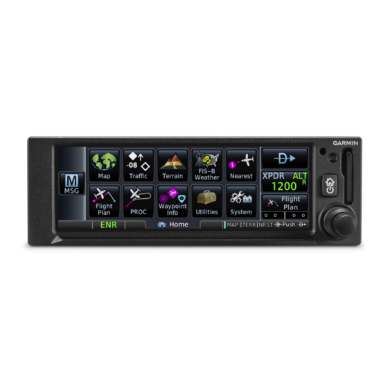
System at a Glance Overview The GPS 175 and GNX 375 are the first 2” by 6.25” panel mount navigators to employ full color capacitive touchscreen technology. The GPS 175 is a TSO-C146e compliant GPS/WAAS navigator with en route, terminal, and precision/non-precision approach capabilities. The GNX 375 combines the functionality of the GPS 175 with a TSO-C112e (Level 2els, Class 1) compliant mode S transponder. -
Page 19: Display Layout
Interface for loading database, exporting log files, and updating software. Compatibility with Flight Stream 510 allows wireless database transfer from the Garmin Pilot app via Database Concierge. Power/Home Key Powers the unit on or off and provides direct access to the Home page. -
Page 20: Unit Functions
Mode S Transponder • Database Concierge Access [3] Requires external ADS-B In product. ADS-B In via 1090 MHz (traffic) and 978 MHz UAT (traffic and weather). Requires Wi-Fi connection via Flight Stream 510. GPS 175/GNX 375 Pilot’s Guide 190-02207-02 Rev. B... -
Page 21: Pilot Interface
Tapping Continue advances to the Instrument Test page. If an instrument remains flagged after one minute, check the status of the associated LRU, then contact a Garmin dealer for support. 1.3.1 Instrument Test To ensure safe operation, continuous built-in test features exercise the unit’s processor, memory, external inputs, and outputs. -
Page 22: Sd Card Slot
Ensure back edge of card is flush with display bezel after insertion. EJECT AN SD CARD Power off the unit. Release the spring latch by pressing lightly on exposed edge of card. GPS 175/GNX 375 Pilot’s Guide 190-02207-02 Rev. B... -
Page 23: Touchscreen
PINCH & STRETCH then bring the fingers close together (pinch) or spread them apart (stretch). Just remember: stretch to zoom in and pinch to zoom out. Use this gesture for: • Magnifying map features 190-02207-02 Rev. B GPS 175/GNX 375 Pilot’s Guide... -
Page 24: Keys
The current state of the function is indicated below the key label. APP ICONS Tapping one of these icons opens the corresponding application. Some apps provide additional icons for accessing functions on subpages (e.g., Utilities, System). GPS 175/GNX 375 Pilot’s Guide 190-02207-02 Rev. B... -
Page 25: Menus
When scrolling, all keys in the list are inactive. Toggle keys either enable or disable list items. In some cases, Settings or Range keys provide access to selectable setting options. Scroll Bar 190-02207-02 Rev. B GPS 175/GNX 375 Pilot’s Guide... -
Page 26: Tabs
Alphanumeric keypads comprise multiple keysets that are accessible by way of swipe or key selection. Selectable Keysets An indicator shows which keyset is active. Keys a through m are active by default. Active Keyset 1-10 GPS 175/GNX 375 Pilot’s Guide 190-02207-02 Rev. B... -
Page 27: Control Knobs
Slot 1 Slot 3 (Map) Additional icons located to Slot 2 the right of the bar indicate available knob functions for the associated page (e.g., zoom, numeric entry). 190-02207-02 Rev. B GPS 175/GNX 375 Pilot’s Guide 1-11... -
Page 28: Screen Captures
With knob depressed, push and release the Home/Power key. A camera icon momentarily shows in the annunciator bar indicating a successful screen capture. To view saved images, remove the SD card and open the “print” folder on a computer. 1-12 GPS 175/GNX 375 Pilot’s Guide 190-02207-02 Rev. B... -
Page 29: Color Conventions
• GPS data • Active flight plan legs • Parallel track Cyan • Pilot-selectable references Gray • Missing or expired data • Product unavailable Blue • • Water Brown • Ground 190-02207-02 Rev. B GPS 175/GNX 375 Pilot’s Guide 1-13... -
Page 30: Compatible Equipment
ADAHRS or ADC with AHRS replacement. GAD 29 adapter Optional LRUs may include GAE 12 altitude encoder compatible equipment from either (applicable to GNX 375 only) Garmin or a third party manufacturer. G3X Touch G500/G600 G500/G600 TXi GMX 200 MX 20 OPTIONAL INTERFACES... -
Page 31: Altitude Encoder
GDL 88 • Precip GTX 345 • METARs Provides datalink traffic FIS-B Weather only: and weather. • Precip • Winds Aloft • METARs/TAFs • AIRMETs • SIGMETs • TFRs • PIREPs 190-02207-02 Rev. B GPS 175/GNX 375 Pilot’s Guide 1-15... - Page 32 INTENTIONALLY LEFT BLANK 1-16 GPS 175/GNX 375 Pilot’s Guide 190-02207-02 Rev. B...
-
Page 33: Get Started
Display Brightness Control ..............2-32 2.23 Scheduled Messages ................2-33 STATUS INDICATIONS 2.24 Alert Types ..................2-34 2.25 System Status Page................2-37 2.26 GPS Status Page ..................2-37 2.27 ADS-B Status Page................2-42 LOGS 2.28 Export to SD Card ................2-43 190-02207-02 Rev. B GPS 175/GNX 375 Pilot’s Guide... -
Page 34: Databases
Load databases via SD card. Once loading completes, you may power off the unit and remove the card. • Transfer databases from a Flight Stream 510 wireless datacard. This method requires the Garmin Pilot app on a portable electronic device. SUPPORTED DATABASES Bodies of water, geopolitical boundary, and road Basemap... -
Page 35: Database Effective Cycles
Notifications for databases not present or available also display in the form of system messages. Tapping Database Info opens the Active Database Information page. Review this list to determine the status of the indicated database. Database Not Present 190-02207-02 Rev. B GPS 175/GNX 375 Pilot’s Guide... -
Page 36: Active And Standby Databases
Information about databases that are not yet effective The Standby DB Info page notifies when no standby databases are available. VIEW COPYRIGHTS Tapping this key displays copyright information for all installed databases. GPS 175/GNX 375 Pilot’s Guide 190-02207-02 Rev. B... -
Page 37: Manual Updates
To open, tap the Databases key on the start-up page. DATABASE SOURCE INDICATION Connext Icon A Connext icon indicates when a database is from Garmin Pilot via wireless transfer. No indication means the database is either from an SD card or the unit’s internal standby queue. - Page 38 Tapping Show All displays a complete list of all databases. This list may include databases that are: • Not yet effective • Older than the currently active database(s) Error Older Icon Timestamp • Unable to update due to an error GPS 175/GNX 375 Pilot’s Guide 190-02207-02 Rev. B...
- Page 39 This key appears when two databases are of the same type and cycle, but pertain to different regions. To specify a database region, tap Select Region, then select the appropriate menu option. 190-02207-02 Rev. B GPS 175/GNX 375 Pilot’s Guide...
-
Page 40: Automatic Updates
SD card to the internal standby queue. BASEMAP AND TERRAIN UPDATES These databases automatically transfer from an SD card without any prompting or progress indications. They do not require pilot confirmation or a unit restart. GPS 175/GNX 375 Pilot’s Guide 190-02207-02 Rev. B... -
Page 41: Database Concierge
Database Concierge allows wireless transfer of databases from a mobile device while the aircraft is on ground. A pilot selects and downloads databases inside the Garmin Pilot app. Transfers occur once Flight Stream 510 establishes a wireless connection inside the aircraft. Database Concierge Transfer Function •... - Page 42 The unit activates any databases that completed transfer before the interruption. Previously selected databases on an SD card or in the internal standby update as well. The message “Transfers interrupted” displays if no databases are available. 2-10 GPS 175/GNX 375 Pilot’s Guide 190-02207-02 Rev. B...
-
Page 43: Wi-Fi Setup
Flight Stream 510 requires power up. Wi-Fi is active, but the unit is waiting to connect with a device. Connection complete. Flight Stream 510 requires Garmin Pilot to be opened in order for database transfer to commence. Garmin Pilot opened and streaming to unit. -
Page 44: Connectivity
AHRS data from built-in sensor [3] [4] GNX 375 only. GNX 375, or GPS 175 with external ADS-B In source. Attitude data does not output to other installed avionics. The internal AHRS sensor is only for use with a portable electronic device. All internal AHRS functions are automatic and do not require pilot action. -
Page 45: Bluetooth Setup
Connext page. • AHRS • Magnetic heading • Flight plan transfer GNX 375, or GPS 175 with external ADS-B In source. 2.7.1 Enabling Bluetooth Tapping Bluetooth Enabled toggles Bluetooth functionality on or off. All associated setting controls and features are unavailable when this function is inactive. -
Page 46: Managing Paired Devices
Once transfer is complete, an advisory message informs that a new flight plan is available for preview. To view the flight plan, acknowledge the advisory and tap Preview. 2-14 GPS 175/GNX 375 Pilot’s Guide 190-02207-02 Rev. B... -
Page 47: Xpdr
The XPDR key becomes available when you: • Enter a squawk code • Open the XPDR menu • View a message • Select the Mode key • Leave the control panel 190-02207-02 Rev. B GPS 175/GNX 375 Pilot’s Guide 2-15... -
Page 48: Xpdr Setup
If the flight ID is editable, tap Flight ID and assign a unique identifier. Flight IDs are alphanumeric (upper-case only) and have an eight character limit. The active flight ID displays by default. 2-16 GPS 175/GNX 375 Pilot’s Guide 190-02207-02 Rev. B... -
Page 49: Xpdr Modes
During Altitude Reporting mode, all aircraft air/ground state transmissions are handled via the transponder and require no pilot action. Always use this mode while in the air and on the ground, unless otherwise requested by ATC. 190-02207-02 Rev. B GPS 175/GNX 375 Pilot’s Guide 2-17... -
Page 50: Squawk Code Keys
IDENT function for 18 seconds. This signal distinguishes the transponder from others on the air traffic controller’s screen. Tapping this key when another Active Squawk page is active immediately opens Code the control panel. 2-18 GPS 175/GNX 375 Pilot’s Guide 190-02207-02 Rev. B... - Page 51 VFR squawk code (active) Reply active IDENT function active Transponder in operation Altitude Reporting Standby Tap to initiate the IDENT function (code unmodified) Tap to accept modified code and initiate IDENT function 190-02207-02 Rev. B GPS 175/GNX 375 Pilot’s Guide 2-19...
-
Page 52: Remote Control
If a failure occurs while the control page is active, the display automatically returns to the previous page. UNIT CONDITION GNX 375 ADS-B interboard communication failure. For information regarding pilot response to a transponder failure, consult the AFMS. 2-20 GPS 175/GNX 375 Pilot’s Guide 190-02207-02 Rev. B... -
Page 53: Ads-B Altitude Reporting
Altitude Reporting Status Flight ID Key (from GDL 88) Anonymous Mode Key When interfaced to a GDL 88 GDL 88 Features transceiver, GPS 175 allows control over • Remote-mount ADS-B some aspects of the ADS-B Out message and provides position transceiver information to the GDL 88. -
Page 54: Ads-B Key
Instead of a flight ID, the unit transmits the call sign "VFR." Tap ADS-B > Anonymous. The key label changes from “Off” to “Armed.” Tapping Anonymous again toggles the mode off. 2-22 GPS 175/GNX 375 Pilot’s Guide 190-02207-02 Rev. B... -
Page 55: Assigning A Flight Id
UNIT CONDITION GPS 175 GDL 88 failure. For information regarding pilot response to ADS-B failures, consult the AFMS. 190-02207-02 Rev. B GPS 175/GNX 375 Pilot’s Guide 2-23... -
Page 56: Pilot Settings
CDI to either side. Options: • 0.30 nm • 1.00 nm • 2.00 nm • Auto Scale selections are reflected in the annunciator bar. Auto Setting Annunciation Manual Setting Annunciation 2-24 GPS 175/GNX 375 Pilot’s Guide 190-02207-02 Rev. B... -
Page 57: Horizontal Alarm Limits
CDI SCALE PHASE ALARM LIMIT Approach 0.30 nm or Auto 0.30 nm 1.00 nm Terminal 1.00 nm or Auto 2.00 nm En Route 2.00 nm or Auto 2.00 nm Oceanic Auto 190-02207-02 Rev. B GPS 175/GNX 375 Pilot’s Guide 2-25... -
Page 58: Cdi On Screen
Lateral Deviation Indicator Visual Approach Guidance Lateral deviation indications Advisory horizontal guidance display when there is an active annunciations appear when a flight plan. visual approach procedure is active. 2-26 GPS 175/GNX 375 Pilot’s Guide 190-02207-02 Rev. B... -
Page 59: Airport Runway Criteria
Typing “0” allows runways of any length to display on Map, appear in the nearest airport list, and be considered for use by Terrain. 190-02207-02 Rev. B GPS 175/GNX 375 Pilot’s Guide 2-27... -
Page 60: Clocks & Timers
System Setup page. Format options include 12 hour, 24 hour, and UTC. If a 12 hour or 24 hour clock is selected: Tap Local Offset > Specify the appropriate offset value from UTC. 2-28 GPS 175/GNX 375 Pilot’s Guide 190-02207-02 Rev. B... -
Page 61: Page Shortcuts
• Terrain Verify shortcut operation once • Flight Plan • complete. Weather Tapping Restore Defaults returns both slots to their default settings (Terrain for Slot 2, Nearest Airport for Slot 3). 190-02207-02 Rev. B GPS 175/GNX 375 Pilot’s Guide 2-29... -
Page 62: Alerts Settings
Smart Airspace settings on the Map page. With the exception of Altitude Buffer, airspace alert options are on/off only. Airspace alerts for Prohibited airspace cannot be disabled. 2-30 GPS 175/GNX 375 Pilot’s Guide 190-02207-02 Rev. B... -
Page 63: Unit Selections
Available only when “User (ºU)” is the active Variation NAV angle SPECIFY UNIT TYPE 1. Review the current unit selections. 2. Tap the applicable parameter key. 3. Select a unit type. 190-02207-02 Rev. B GPS 175/GNX 375 Pilot’s Guide 2-31... -
Page 64: Display Brightness Control
Installer configured curves determine the amount of change in brightness that occurs in response to a control adjustment. If brightness control is not satisfactory, contact a Garmin dealer to adjust the lighting curves. 2-32 GPS 175/GNX 375 Pilot’s Guide... -
Page 65: Scheduled Messages
This function is accessible from either the Scheduled Messages page or the system message list. RESET TIMER Restarts the countdown timer. DELETE MESSAGE Confirming this request removes the selected message from the list. 190-02207-02 Rev. B GPS 175/GNX 375 Pilot’s Guide 2-33... -
Page 66: Status Indications
Function or mode specific advisories. These appear as unobstructed annunciations in the annunciator bar. Advisory Messages & Annunciations System Messages List Mode Advisory Annunciation Message Key For a complete list of all system-related advisories, refer to section 6 2-34 GPS 175/GNX 375 Pilot’s Guide 190-02207-02 Rev. B... -
Page 67: Alert Annunciations
Alerts and informational advisories annunciate in the annunciator bar along the bottom of the screen. Alerts, Inhibits Flight From/To Procedure Waypoint and and Test Mode Phase Power Off Advisories Advisories Annunciator Bar 190-02207-02 Rev. B GPS 175/GNX 375 Pilot’s Guide 2-35... -
Page 68: Pop-Up Alerts
A Mute Alert key allows you silence the active traffic alert voice message. * GPS 175 systems interfaced to a traffic system (GDL 88 or GTX 345): Aural alerts are available. They are provided directly from the traffic system LRU to the audio panel. -
Page 69: System Status Page
• Outer circle represents the horizon (with north at the top of the circle) • Inner circle represents 45° above the horizon • Center point shows the position directly overhead 190-02207-02 Rev. B GPS 175/GNX 375 Pilot’s Guide 2-37... - Page 70 Data collected, but receiver is not using satellite in the Cyan bar, solid position solution. Data collected, satellite in use in the current position Green bar, solid solution. Differential corrections are in use (e.g., WAAS). D (inside bar) 2-38 GPS 175/GNX 375 Pilot’s Guide 190-02207-02 Rev. B...
-
Page 71: Circle Of Uncertainty
NOTE Under FAR parts 91, 121, 125, and 135, FDE must be used prior to all oceanic or remote area flights using the GPS 175/GNX 375 as a primary means of navigation. This program uses an algorithm to predict FDE availability. If the unit has not been in operation for more than six months, acquiring satellite data to establish almanac and satellite orbit information may take 5 to 10 minutes. -
Page 72: Sbas Providers
3-D navigation mode. GPS receiver computes altitude 3D Nav using satellite data. 3-D navigation mode. Differential corrections from SBAS 3D Diff Nav provider are in use. Satellite coverage is insufficient to pass built-in integrity monitoring tests. 2-40 GPS 175/GNX 375 Pilot’s Guide 190-02207-02 Rev. B... -
Page 73: Gps Alerts
On-board hardware failure. Yellow “No GPS Position” Unit cannot determine a GPS annunciation. Loss of Position position solution. Ownship icon not present 190-02207-02 Rev. B GPS 175/GNX 375 Pilot’s Guide 2-41... -
Page 74: Ads-B Status Page
Get Started 2.27 ADS-B Status Page View last uplink time and GPS source information. FEATURE REQUIREMENTS • GDL 88 or GTX 345 ADS-B transceiver (GPS 175 only) • GNX 375 UPLINK TIME This field displays the number of minutes TEXT MINUTES SINCE since last uplink. -
Page 75: Logs
Generates log files automatically upon unit power-up • Overwrites oldest file when the internal log reaches capacity • Exports to the “log_files” folder on the SD card ADS-B log files may take several minutes to export. 190-02207-02 Rev. B GPS 175/GNX 375 Pilot’s Guide 2-43... - Page 76 INTENTIONALLY LEFT BLANK 2-44 GPS 175/GNX 375 Pilot’s Guide 190-02207-02 Rev. B...
-
Page 77: Navigation
Direct To Basics ...................3-40 WAYPOINTS 3.14 Waypoint Information................3-45 3.15 Waypoint Selection................3-48 3.16 Create User Waypoints ................3-51 3.17 Nearest....................3-55 PROCEDURES 3.18 Flight Procedure Basics.................3-58 3.19 Departures ..................3-62 3.20 Arrivals ....................3-64 3.21 Approaches ..................3-66 190-02207-02 Rev. B GPS 175/GNX 375 Pilot’s Guide... - Page 78 Navigation NAVIGATION APPS & FUNCTIONS Menu selections vary based on features and optional equipment installed with Garmin avionics. NEXRAD and Terrain overlays are mutually exclusive. GPS 175/GNX 375 Pilot’s Guide 190-02207-02 Rev. B...
-
Page 79: Map
Customizable data field appearing in each corner of the map. By default, these display: distance, track, ground speed, and desired track NAV Range Ring Displays current direction of travel on a rotating compass. Orientation: Magnetic north 190-02207-02 Rev. B GPS 175/GNX 375 Pilot’s Guide... - Page 80 0.50 nm 10.0 nm FEATURE LABELS To maintain readability, map feature labels remain uniform at all zoom levels. TRAFFIC UNITS System Units page selections do not affect the display of traffic on Map. GPS 175/GNX 375 Pilot’s Guide 190-02207-02 Rev. B...
- Page 81 FEATURE Traffic Surface Conditions Ownship Airspace Flight Plan Waypoints Terrain-FLTA Airways Point Obstacles Reference Grid Line Obstacles Radar Coverage NEXRAD METAR SafeTaxi Winds Aloft Runways SIGMET Terrain AIRMET Basemap PIREP Topo AIREP 190-02207-02 Rev. B GPS 175/GNX 375 Pilot’s Guide...
-
Page 82: Map Setup
Expand the forward-looking view for improved situational awareness RESTORE MAP SETTINGS With the exception of user fields, this key restores all original factory map settings. On/off functionality only. NEXRAD and Terrain overlays are mutually exclusive. GPS 175/GNX 375 Pilot’s Guide 190-02207-02 Rev. B... -
Page 83: Configure User Fields
Map and the Active FPL page. They reappear in their respective corners when you return to the Home page or use the knob to move between Map and any other application. 190-02207-02 Rev. B GPS 175/GNX 375 Pilot’s Guide... -
Page 84: Map Orientation
Label below the North indicator shows the current orientation. This label is absent when the info banner is active. North Up is useful when zoomed out to view the entire route or a frontal system on a NEXRAD display. GPS 175/GNX 375 Pilot’s Guide 190-02207-02 Rev. B... -
Page 85: North Up Above
3.1.5 TOPO Scale Displays a topographical elevation scale. To remove the scale: • Toggle TOPO Scale off • Tap Restore User Fields 190-02207-02 Rev. B GPS 175/GNX 375 Pilot’s Guide... -
Page 86: Range Ring
3.1.8 Ahead View FEATURE LIMITATIONS • Not available when page orientation is North Up Repositions ownship near the bottom of the page to expand the view ahead. 3-10 GPS 175/GNX 375 Pilot’s Guide 190-02207-02 Rev. B... -
Page 87: Map Detail
Medium Cities Large Cities Freeways Highways Roads Railroads Basemap Labels VORs NDBs Line Obstacles Point Obstacles Airspaces that are not prohibited or restricted Waypoints SafeTaxi Restricted Airspaces Prohibited Airspaces Present Removed 190-02207-02 Rev. B GPS 175/GNX 375 Pilot’s Guide 3-11... - Page 88 VOR/DME VORTAC Runway extension [1] Symbol depicts orientation of longest runway. LAND DATA SYMBOLS Railroad National Highway River/Lake Freeway State/Province Border Small City Local Road Medium City Local Highway Large City 3-12 GPS 175/GNX 375 Pilot’s Guide 190-02207-02 Rev. B...
-
Page 89: Map Interactions
Tapping any object or location on the map displays a map pointer and an information banner. MAP POINTER This symbol indicates point of contact on the map. A gray circle highlights any selected waypoint or obstacle. 190-02207-02 Rev. B GPS 175/GNX 375 Pilot’s Guide 3-13... - Page 90 To move the selector through each object in proximity of the map pointer, select an object and tap Next. Overlapping objects may be difficult to identify at a given zoom level. Stack Active Selection 3-14 GPS 175/GNX 375 Pilot’s Guide 190-02207-02 Rev. B...
-
Page 91: Graphical Flight Plan Editing
Graphical editing allows quick changes to the active flight plan from the map display. Map provides identifier keys for selecting waypoints that are stacked or in close proximity. If the displayed options are not preferred, tap away or select Cancel. 190-02207-02 Rev. B GPS 175/GNX 375 Pilot’s Guide 3-15... - Page 92 You can edit, add, or omit flight plan legs by tapping or dragging your finger directly on the map. Existing Selected Waypoint 1. Tap any location on the map. 2. Tap Graphical Edit. 3-16 GPS 175/GNX 375 Pilot’s Guide 190-02207-02 Rev. B...
- Page 93 Delete any existing flight plan before attempting to graphically edit a direct-to waypoint. Map does not allow the addition of an intermediate waypoint between the current position and a direct-to waypoint unless the waypoint is in the flight plan. 190-02207-02 Rev. B GPS 175/GNX 375 Pilot’s Guide 3-17...
- Page 94 Map page. 1. Tap any location on the map > Graphical Edit. 2. Begin tapping waypoints to add them to the temporary flight plan. 3. Tap Done. 3-18 GPS 175/GNX 375 Pilot’s Guide 190-02207-02 Rev. B...
-
Page 95: Map Overlays
NEXRAD Obstacles & Weather product and traffic overlays Wires • METAR are optional on GPS 175. They are available only when configured for ADS-B In equipment. 3.3.1 Overlay Controls Control keys enable the specified overlay function only and do not activate interfaced equipment. Control keys remain active even in the absence of required data. - Page 96 Navigation TRAFFIC • Overlays traffic information • Filter selection on the Traffic page determines altitude range • Feature optional for GPS 175 NEXRAD • Overlays datalink precipitation weather information • Options include: CONUS, Regional, or off (none) • Feature optional for GPS 175 METAR •...
- Page 97 High altitude airways are green, low altitude airways are gray OBSTACLES & WIRES • Overlays obstacle and wire data • Color shading depicts an object’s elevation relative to the aircraft’s altitude 190-02207-02 Rev. B GPS 175/GNX 375 Pilot’s Guide 3-21...
-
Page 98: Overlay Status Icons
The absence of an overlay icon means one of two possible conditions: 1. Overlay not present at the current detail level or zoom setting. 2. Overlay control is off. METAR NEXRAD Obstacle Power Line Traffic Terrain Data not available 3-22 GPS 175/GNX 375 Pilot’s Guide 190-02207-02 Rev. B... -
Page 99: Smart Airspace
[1] Vertical distance above and below aircraft altitude. AIRSPACE DATA SYMBOLS Class B Altitude Class C/TCA Label (ceiling/floor) Class C Altitude Class D Label (ceiling/floor) Class D Altitude Restricted/Prohibited Label (ceiling only) Class B/TMA Other/ADIZ 190-02207-02 Rev. B GPS 175/GNX 375 Pilot’s Guide 3-23... -
Page 100: Safetaxi
Airport diagram overlay that includes hot spot information • Aircraft position relative to taxiways, runways, and airport landmarks • Pilot selectable range options SAFETAXI DATA SYMBOLS Runway Taxiway Helipad Construction Area Airport Beacon Unpaved Parking 3-24 GPS 175/GNX 375 Pilot’s Guide 190-02207-02 Rev. B... - Page 101 • Complex ramp areas • Directional limitations • Limited wing-tip clearance • Overflight risk CONSTRUCTION SPOTS There are no expanded detail keys or notes associated with construction areas. Construction Area Border 190-02207-02 Rev. B GPS 175/GNX 375 Pilot’s Guide 3-25...
-
Page 102: Active Flight Plan
Displays up to 100 waypoints for an active flight plan Active Flight Plan Page Selectable Data Field Columns Add Waypoint Key Waypoint Identifier Column Leg Data Active Leg Indicator Waypoint Type Icon Current Waypoint 3-26 GPS 175/GNX 375 Pilot’s Guide 190-02207-02 Rev. B... - Page 103 Symbols denote active leg status on the GPS NAV indicator. Fix type symbols (e.g., FAF, MAP) correspond with labels appearing on the flight plan. Arc Left Holding Pattern (Right Turns) Holding Pattern (Left Turns) MAHP Right Arrow Parallel Track Direct To Arc Right 190-02207-02 Rev. B GPS 175/GNX 375 Pilot’s Guide 3-27...
-
Page 104: Collapse All Airways
OBS selector on HSI or CDI. The following example shows OBS course selection for To waypoint UBG. Direct To FPL Tab Route Indication 3-28 GPS 175/GNX 375 Pilot’s Guide 190-02207-02 Rev. B... - Page 105 Tapping the key again resumes automatic sequencing of waypoints (normal mode). SUSPEND/UNSUSPEND SUSP UNSUSP This key displays for leg types This key displays for legs that that do not support OBS. auto suspend (e.g., leg holds, missed approaches). 190-02207-02 Rev. B GPS 175/GNX 375 Pilot’s Guide 3-29...
-
Page 106: Dead Reckoning
DR mode annunciation replaces ENR or OCN • Terrain functionality is not available • Traffic displays on its dedicated page only • CDI is not available Dead reckoning mode ends once GPS position is restored. 3-30 GPS 175/GNX 375 Pilot’s Guide 190-02207-02 Rev. B... -
Page 107: Parallel Track
Corresponding fix symbols on the GPS NAV key and flight plan indicate when the active leg is on a parallel track. A graphical depiction overlays on the map. GPS NAV Key 190-02207-02 Rev. B GPS 175/GNX 375 Pilot’s Guide 3-31... - Page 108 2. Tap Offset and specify a distance between 1 nm and 99 nm. 3. Tap Direction and select left of track or right of track. 4. Tap Activate. To deactivate parallel track, tap Menu > Deactivate PTK. 3-32 GPS 175/GNX 375 Pilot’s Guide 190-02207-02 Rev. B...
-
Page 109: Edit Data Fields
Each catalog entry includes a route identifier, the route distance, and en route safe altitude. The identifiers of the departure and destination waypoints Comment Distance comprise the route identifier. En Route Safe Altitude 190-02207-02 Rev. B GPS 175/GNX 375 Pilot’s Guide 3-33... -
Page 110: Catalog Route Options
Create a copy of the selected flight plan. A copy may be used as a starting point for creating a similar flight plan. Select the copy and tap Edit to make modifications. 3-34 GPS 175/GNX 375 Pilot’s Guide 190-02207-02 Rev. B... - Page 111 1. Open the catalog. 2. Tap Menu > Delete All. 3. Confirm the request to clear the catalog. 4. Tap Delete Pending. 5. Confirm the request to remove all flight plans pending preview. 190-02207-02 Rev. B GPS 175/GNX 375 Pilot’s Guide 3-35...
-
Page 112: Create A Flight Plan
4. Add waypoints using the provided search options. 5. Tap Menu > Preview > Store or ACTV (Activate). As a general practice, never save flight plans with modified procedures in the catalog. 3-36 GPS 175/GNX 375 Pilot’s Guide 190-02207-02 Rev. B... -
Page 113: Flight Plan Waypoint Options
Specify hold parameters and preview holding patterns from a dedicated menu page. Open the dedicated information page for the selected WPT Info waypoint. Remove the selected waypoint or hold from the active Remove flight plan. 190-02207-02 Rev. B GPS 175/GNX 375 Pilot’s Guide 3-37... -
Page 114: Flight Plan Map Overlay
LEG STATUS COLOR overlay on the Map page and are display Active Magenta only. Next & Future White Past or Inactive Gray Previous Leg(s) Active Leg Next Leg(s) Leg Status Indications 3-38 GPS 175/GNX 375 Pilot’s Guide 190-02207-02 Rev. B... -
Page 115: Gps Nav Status
CDI Scale Active Label changes to show active Only from-to waypoints display route identifiers (from-to-next) when the CDI scale is active. and leg types. This function is controlled via the System Setup screen. 190-02207-02 Rev. B GPS 175/GNX 375 Pilot’s Guide 3-39... -
Page 116: Direct To
• An off-route course quicker alternative to using the • active flight plan. User-defined holds 3.13.1 Direct To Search Tabs Search tabs include: Waypoint, FPL, and NRST APT Direct To Window 3-40 GPS 175/GNX 375 Pilot’s Guide 190-02207-02 Rev. B... -
Page 117: Direct To Activation
GPS Nav key changes to indicate active leg status. For convenience, you may open the Direct To function by pushing the control knob. Once a waypoint is selected, pushing the knob again activates the direct-to course. 190-02207-02 Rev. B GPS 175/GNX 375 Pilot’s Guide 3-41... -
Page 118: Navigating Direct To
Bearing, distance, and map 3. Activate the selection. coordinates display on the Waypoint tab. You can modify direct-to routes on Map using the Graphical Edit function the same as you would a flight plan. 3-42 GPS 175/GNX 375 Pilot’s Guide 190-02207-02 Rev. B... -
Page 119: Removing A Direct-To Course
Assigns the leg nearest to the aircraft’s position as the active leg • Resumes waypoint sequencing If no active flight plan exists, the aircraft continues on its current heading without any navigation guidance. 190-02207-02 Rev. B GPS 175/GNX 375 Pilot’s Guide 3-43... -
Page 120: User Holds
Active FPL page. CREATE & ACTIVATE A HOLD Create a hold for a direct-to waypoint. From the Waypoint tab: 1. Tap Hold. 2. Specify hold parameters. 3. Tap Load Hold > Hold Activate. 3-44 GPS 175/GNX 375 Pilot’s Guide 190-02207-02 Rev. B... -
Page 121: Waypoints
FIS-B (viewing NOTAMs) • Navigation database containing VRP waypoint data FEATURE LIMITATIONS • 2-D maps provide zoom functionality only • FIS-B transmits distant and FDC NOTAMs within 100 nm of radio station position 190-02207-02 Rev. B GPS 175/GNX 375 Pilot’s Guide 3-45... - Page 122 (e.g., “NW USA”) depictions) • Identifier and type icon As you approach an airport, use the Preview function to orient yourself for such things as pattern entry or runway alignment. 3-46 GPS 175/GNX 375 Pilot’s Guide 190-02207-02 Rev. B...
- Page 123 Visual Reporting Point Data fields: • Nearest VRP (identifier, type icon, bearing, and distance) Non-Directional Beacon Data fields: • Frequency • Nearest airport (identifier, type icon, bearing, and distance) • Marker description 190-02207-02 Rev. B GPS 175/GNX 375 Pilot’s Guide 3-47...
-
Page 124: Waypoint Selection
Icon Matching waypoint entries typically change with the addition of each typed character. An information key reflects each matching entry. Info Key “No matches found” and “Duplicate found” annunciate when applicable. 3-48 GPS 175/GNX 375 Pilot’s Guide 190-02207-02 Rev. B... -
Page 125: Search Tabs
To list all classes, select All. FLIGHT PLAN Lists all waypoints contained in the active flight plan. USER Lists up to 1,000 user-defined waypoints. 190-02207-02 Rev. B GPS 175/GNX 375 Pilot’s Guide 3-49... - Page 126 Tap Search Facility Name to begin search. SEARCH BY CITY Lists all airports, NDBs, and VORs found in proximity of the city. Tap Search City Name to begin search. 3-50 GPS 175/GNX 375 Pilot’s Guide 190-02207-02 Rev. B...
-
Page 127: Create User Waypoints
NAV radio to tune each VOR and specify the radials to fly inbound and outbound. 190-02207-02 Rev. B GPS 175/GNX 375 Pilot’s Guide 3-51... -
Page 128: Define Waypoint Criteria
Assign the waypoint a temporary status. Identifier remains Temporary available until the next unit power cycle. Add the new identifier to the used waypoints list. The Create associated information page opens automatically for viewing and editing purposes. 3-52 GPS 175/GNX 375 Pilot’s Guide 190-02207-02 Rev. B... - Page 129 Set the Waypoint Position using one of the following options. Radial/Radial: Specify a waypoint and radial for each of the two reference points. Radial/Distance: Specify the reference waypoint, radial, and distance. LAT/LON: Specify the point’s latitude and longitude. 190-02207-02 Rev. B GPS 175/GNX 375 Pilot’s Guide 3-53...
-
Page 130: Edit An Existing User Waypoint
The Import Waypoints key appears when the unit detects a user waypoint on the datacard. 1. Insert datacard containing user waypoints. 2. From the Home page, tap Waypoint Info > Import Waypoints. 3. Acknowledge the pop-up message. 3-54 GPS 175/GNX 375 Pilot’s Guide 190-02207-02 Rev. B... -
Page 131: Nearest
Nearest Non-Directional Beacon • Identifier • symbol • distance • bearing • frequency Nearest User Waypoint • Identifier • symbol • distance • bearing Nearest Airspace • Identifier • symbol • proximity 190-02207-02 Rev. B GPS 175/GNX 375 Pilot’s Guide 3-55... - Page 132 MULTIPLE FREQUENCIES This key displays when more than one frequency is available at the indicated range. Applicable to functions displaying information only (ARTCC, FSS, and WX FREQ). 3-56 GPS 175/GNX 375 Pilot’s Guide 190-02207-02 Rev. B...
-
Page 133: Procedures
Runway: Select a runway for the selected airport. Preview: View a 2-D map of the surrounding area (includes SafeTaxi airport depictions). For page specific controls, refer to the appropriate procedure description. 190-02207-02 Rev. B GPS 175/GNX 375 Pilot’s Guide 3-57... -
Page 134: Flight Procedure Basics
Map complements your printed approach plates by improving situational awareness during the approach. It does not replace printed approach plates. Always fly an approach as it appears on the approach plate. 3-58 GPS 175/GNX 375 Pilot’s Guide 190-02207-02 Rev. B... - Page 135 Composite CDI. When interfaced to a composite type CDI, the composite CDI flag shows only “TO” indications. Always refer to the FROM/TO field on the annunciator bar when using composite CDI. FROM/TO Field 190-02207-02 Rev. B GPS 175/GNX 375 Pilot’s Guide 3-59...
-
Page 136: Gps Flight Phase Annunciations
Aircraft’s estimated height is lower than the final approach waypoint height by approximately 50 meters LOW ALT • For LNAV+V, LNAV/VNAV, or LPV approaches • Not active when Terrain is operational 3-60 GPS 175/GNX 375 Pilot’s Guide 190-02207-02 Rev. B... - Page 137 CDI full-scale deflection: 2.0 nm or current CDI scale selection, whichever is smaller Visual Approach • Vertical guidance based on advisory terrain avoidance VISUAL calculations • CDI scaling is identical to LPV approaches 190-02207-02 Rev. B GPS 175/GNX 375 Pilot’s Guide 3-61...
-
Page 138: Departures
8. Scroll the flight plan to view all departure waypoints. To change or remove the departure: • Tap the existing flight plan departure • Select a different one. • Tap Remove Departure. 3-62 GPS 175/GNX 375 Pilot’s Guide 190-02207-02 Rev. B... -
Page 139: Flight Plan Departure Options
Selecting a departure on the flight plan opens a menu. Changes to the active flight plan take effect immediately. • Select a new departure • Remove the selected departure from the flight plan 190-02207-02 Rev. B GPS 175/GNX 375 Pilot’s Guide 3-63... -
Page 140: Arrivals
8. Scroll the flight plan to view all arrival waypoints. To change or remove the arrival: • Tap the existing flight plan arrival. • Select a different one. • Tap Remove Arrival. 3-64 GPS 175/GNX 375 Pilot’s Guide 190-02207-02 Rev. B... -
Page 141: Flight Plan Arrival Options
Selecting an arrival on the flight plan opens a menu. Changes to the active flight plan take effect immediately. • Select a new arrival • Remove the selected arrival from the flight plan 190-02207-02 Rev. B GPS 175/GNX 375 Pilot’s Guide 3-65... -
Page 142: Approaches
5. Tap Runway > Select a runway. 6. Tap Preview > Review the approach diagram and sequence list. 7. Tap Load Approach. The Active FPL page opens. 8. Scroll the flight plan to view all approach waypoints. 3-66 GPS 175/GNX 375 Pilot’s Guide 190-02207-02 Rev. B... - Page 143 This annunciation appears in the procedure field of the annunciator bar. Suspended approaches typically occur during: • Holding patterns • Crossing the missed approach point • Climb to altitude legs • Hold to altitude legs 190-02207-02 Rev. B GPS 175/GNX 375 Pilot’s Guide 3-67...
-
Page 144: Flight Plan Approach Options
Activate the selected approach • Activate vectors to final for the selected approach • Activate a missed approach • Select a new approach • Remove the selected approach from the flight plan 3-68 GPS 175/GNX 375 Pilot’s Guide 190-02207-02 Rev. B... -
Page 145: Missed Approach
Upon reaching the missed approach point, a pop-up presents two options. To continue with sequencing suspended, tap Remain Suspended. To receive guidance to the missed approach hold point, tap Activate GPS Missed Approach. 190-02207-02 Rev. B GPS 175/GNX 375 Pilot’s Guide 3-69... -
Page 146: Approach Hold
REMOVE HOLDING PATTERN 1. Select the hold. 2. Tap Remove. 3. Confirm the request. EXIT HOLDING PATTERN 1. Tap SUSP. 2. Select the hold. 3. Tap Exit Hold. 4. Confirm the request. 3-70 GPS 175/GNX 375 Pilot’s Guide 190-02207-02 Rev. B... - Page 147 If you need to go around the holding pattern again to lose extra altitude or speed, tap SUSP to manually suspend waypoint sequencing before crossing the holding waypoint the second time. If you have already passed the waypoint, re-activate the holding pattern. 190-02207-02 Rev. B GPS 175/GNX 375 Pilot’s Guide 3-71...
-
Page 148: Dme Arc
• Manual arc leg activation area. once aircraft is near the arc DME Arc Intermediate Initial Approach Approach 1/2 X Arcing Fix (VOR) 3-72 GPS 175/GNX 375 Pilot’s Guide 190-02207-02 Rev. B... -
Page 149: Rf Legs
“SUSP” annunciates at the bottom of the screen. Sequencing resumes once the aircraft is on the To side of the final approach fix and within full-scale deflection. 190-02207-02 Rev. B GPS 175/GNX 375 Pilot’s Guide 3-73... -
Page 150: Ils Approach
The glidepath is a light dashed line on the vertical profile (Jeppesen charts only) with an associated glidepath angle (usually in the 3.00 degree range) to assist in maintaining a constant vertical glidepath, similar to an ILS glideslope. 3-74 GPS 175/GNX 375 Pilot’s Guide 190-02207-02 Rev. B... - Page 151 Unit reverts to terminal limits of 1 nm to support navigation to the missed approach After the aircraft passes final approach fix: • Approach aborts due to a loss of WAAS integrity • Pilot captures the glideslope (method is same as for ILS glideslope) 190-02207-02 Rev. B GPS 175/GNX 375 Pilot’s Guide 3-75...
- Page 152 Prepare aircraft for missed approach operation: • Pilot taps UNSUSP (sequences missed approach), then follows the unit provided guidance to the missed approach hold point and holds 3-76 GPS 175/GNX 375 Pilot’s Guide 190-02207-02 Rev. B...
- Page 153 CDI scaling tightens from 2 degrees or 0.3 nm full-scale deflection, whichever is smaller 60 seconds before final approach fix: • System verifies GPS position integrity is within the horizontal limits to complete the LP non-precision approach 190-02207-02 Rev. B GPS 175/GNX 375 Pilot’s Guide 3-77...
- Page 154 Final course segment becomes the active flight plan leg on Map Approaching missed approach point: • Advisory message: “Arriving at Waypoint.” At the missed approach point: • Pilot initiates missed approach, if necessary 3-78 GPS 175/GNX 375 Pilot’s Guide 190-02207-02 Rev. B...
- Page 155 The pilot is still responsible for descending to the correct altitude at each step down. The result is still an MDA and missed approach point. 190-02207-02 Rev. B GPS 175/GNX 375 Pilot’s Guide 3-79...
-
Page 156: Visual Approach
After loading the approach, a shortened magenta line shows on the map. If obstructions are within 3 nm to the runway, along the approach path, advisory vertical guidance is not available. 3-80 GPS 175/GNX 375 Pilot’s Guide 190-02207-02 Rev. B... - Page 157 For more about Visual Approach key configuration, refer to section 3.1.4. LOAD A VISUAL APPROACH FROM PROCEDURES Two methods: Home > PROC > Approach Home > Waypoint Info > Airport > PROC > Select an approach (similar to published instrument approaches) 190-02207-02 Rev. B GPS 175/GNX 375 Pilot’s Guide 3-81...
-
Page 158: Autopilot Outputs
(i.e., angular CDI scaling and glideslope capture for LPV or other vertically guided GPS approaches). ENABLE AUTOPILOT OUTPUTS 1. Acknowledge the advisory message. 2. Tap Enable APR Output. 3. Follow the unit provided guidance. 3-82 GPS 175/GNX 375 Pilot’s Guide 190-02207-02 Rev. B... -
Page 159: Planning
Planning Planning VERTICAL CALCULATOR VCALC Page ..................4-3 VCALC Setup ..................4-4 FUEL PLANNING Fuel Planning Page ................4-5 DALT/TAS/WIND CALCULATOR DALT/TAS/Wind Page ................4-8 RAIM PREDICTION RAIM Prediction Page ................4-11 190-02207-02 Rev. B GPS 175/GNX 375 Pilot’s Guide... - Page 160 Point-to-Point mode only. Flight Plan mode only. From key not selectable when Present Position (P.POS) function is active. Function not selectable when sensor data in use. Indicates pressure altitude when sensor data in use. GPS 175/GNX 375 Pilot’s Guide 190-02207-02 Rev. B...
-
Page 161: Vertical Calculator
Create a 3-D profile to guide you from your present position and altitude to a final (target) altitude at a specified location. Once defined, you may configure message alerts and additional data on the Map page to stay informed of your progress. 190-02207-02 Rev. B GPS 175/GNX 375 Pilot’s Guide... -
Page 162: Vcalc Setup
• Displaying VCALC related advisory messages RESTORE DEFAULTS Resets VCALC page settings to their default values. Excludes Target Waypoint. DISPLAY MESSAGES Allows VCALC related advisory messages to display on the Messages page. GPS 175/GNX 375 Pilot’s Guide 190-02207-02 Rev. B... -
Page 163: Fuel Planning
It is not a direct indication of actual fuel quantity once the aircraft reaches its destination. • All data entries on this page are used exclusively by the Fuel Planning app. • Fuel computations are for planning purposes only. 190-02207-02 Rev. B GPS 175/GNX 375 Pilot’s Guide... - Page 164 Use Sensor Data key is active • This value is used to calculate fuel statistics when you press the Compute key Adjust fuel on board and fuel flow values as necessary to account for changes in performance. GPS 175/GNX 375 Pilot’s Guide 190-02207-02 Rev. B...
-
Page 165: Computing Fuel Statistics
From waypoint. 3. Specify the amount of fuel on board and average fuel flow rate. 4. Specify ground speed or elect to use sensor data. 5. Tap Compute. 190-02207-02 Rev. B GPS 175/GNX 375 Pilot’s Guide... -
Page 166: Dalt/Tas/Wind Calculator
4.4.1 Editing Input Data Available selections are dependent on sensor data use. TAT and HDG may also be available via an external data source. Not Selectable GPS 175/GNX 375 Pilot’s Guide 190-02207-02 Rev. B... - Page 167 Ground Speed Specify ground speed [2] Toggles to Pressure ALT indication when sensor data in use. Not selectable when sensor data in use. This field is absent when sensor data is in use. 190-02207-02 Rev. B GPS 175/GNX 375 Pilot’s Guide...
-
Page 168: Computing Dalt/Tas/Wind Statistics
Wind data calculations are dependent on true airspeed, aircraft heading, and ground speed. Wind direction is dependent on the NAV Angle system unit setting. If wind speed is zero, wind direction displays as dashes. 4-10 GPS 175/GNX 375 Pilot’s Guide 190-02207-02 Rev. B... -
Page 169: Raim Prediction
RAIM is not available • Near 100% availability in Oceanic, En route, and Terminal phases of flight • Waypoint Identifier, Arrival Date, and Arrival Time setup keys • Compute RAIM key 190-02207-02 Rev. B GPS 175/GNX 375 Pilot’s Guide 4-11... -
Page 170: Calculating Raim Status
Dashes indicate when the destination waypoint is invalid. ANNUNCIATION DESCRIPTION Computing Status is pending. RAIM Available RAIM is available at the specified waypoint. RAIM Unavailable RAIM is not available at the specified waypoint. 4-12 GPS 175/GNX 375 Pilot’s Guide 190-02207-02 Rev. B... -
Page 171: Hazard Awareness
Traffic Interactions ................5-27 5.12 Traffic Annunciations................5-28 5.13 Traffic Alerting..................5-29 TERRAIN AWARENESS 5.14 Terrain Configurations .................5-31 5.15 Database Limitations................5-33 5.16 Terrain Display ..................5-34 5.17 Terrain Setup ..................5-35 5.18 Terrain Proximity..................5-36 5.19 Terrain Alerting ...................5-39 190-02207-02 Rev. B GPS 175/GNX 375 Pilot’s Guide... - Page 172 APPS & FUNCTIONS Menu selections vary based on features and optional equipment installed with Garmin avionics. GPS 175: Feature availability dependent upon unit configuration. Requires external ADS-B In product (GDL 88, GTX 345) and FIS-B. GPS 175/GNX 375 Pilot’s Guide...
-
Page 173: Weather Awareness
Datalink weather is not intended to replace weather briefings or in-flight weather reports from AFSS or ATC. FEATURE REQUIREMENTS • GPS 175 with UAT receiver (GDL 88, GTX 345) and FIS-B • GNX 375 and FIS-B The FAA provides FIS-B as a Surveillance and Broadcast Service operating on the UAT (978 MHz) frequency band. -
Page 174: Per Faa Tso-C157B
NOTAMs received via FIS-B may not be a complete listing. Active NOTAMs are removed from the FIS-B data stream 30 days after issuance. Before flight, review all necessary aeronautical and meteorological information from official sources. For more information, consult AC 00-63A or latest revision. GPS 175/GNX 375 Pilot’s Guide 190-02207-02 Rev. B... -
Page 175: Fis-B Weather Display
Includes source key and animation control. Source options include CONUS, Regional, or Combined. Zoom Scale Value adjusts with changes to the current magnification. Product Timestamp Approximate time of data collection for each active weather product. 190-02207-02 Rev. B GPS 175/GNX 375 Pilot’s Guide... -
Page 176: Fis-B Weather Setup
From the setup menu, tap FIS-B WX Status > FIS-B Enabled. This function is also accessible from the ADS-B Status page: Home > System > ADS-B Status > FIS-B WX Status > FIS-B Enabled GPS 175/GNX 375 Pilot’s Guide 190-02207-02 Rev. B... -
Page 177: Fis-B Weather Interactions
LEGENDS A scrollable legend provides relevant product colors and symbols. Definitions are organized by product function. 1. Tap Menu > Legend. 2. Use the inner knob to view the available product legends. 190-02207-02 Rev. B GPS 175/GNX 375 Pilot’s Guide... -
Page 178: Fis-B Weather Products
View the status of all FIS-B weather products. States include: • Unavailable • Awaiting Data • Data Available From the FIS-B menu, tap FIS-B WX Status. This page is also accessible from the ADS-B Status page. GPS 175/GNX 375 Pilot’s Guide 190-02207-02 Rev. B... -
Page 179: Product Age
FIS-B weather product update and transmission intervals are published in the SBS Description Document associated with TSO-C157b. This information is available electronically at the FAA’s Regulatory and Guidance Library: https://rgl.faa.gov/ 190-02207-02 Rev. B GPS 175/GNX 375 Pilot’s Guide... -
Page 180: Fis-B Nexrad
Play and stop controls are active when three or more NEXRAD images are available for playback. 5-10 GPS 175/GNX 375 Pilot’s Guide 190-02207-02 Rev. B... - Page 181 Each weather pixel varies with latitude. Above 60º latitude, pixel block width doubles to 3 min/nm for regional maps • Both CONUS and Regional NEXRAD images display simultaneously Combined • White hash mark indicates regional boundary 190-02207-02 Rev. B GPS 175/GNX 375 Pilot’s Guide 5-11...
-
Page 182: Metars And Tafs
Ceiling 500 to 1000 ft AGL and/or visibility one to three miles. Low IFR Ceiling below 500 ft AGL and/or visibility less than one mile. Unknown Ceiling and/or visibility data unavailable. 5-12 GPS 175/GNX 375 Pilot’s Guide 190-02207-02 Rev. B... -
Page 183: Airmets
Widespread mountain obscuration due to clouds, MTN OBSR precipitation, smoke, haze, mist, or fog • Sustained surface winds >30 kt and/or potential Surface Winds non-convective wind shear below 2,000 ft AGL 190-02207-02 Rev. B GPS 175/GNX 375 Pilot’s Guide 5-13... -
Page 184: Sigmets
PIREP SYMBOLS Routine (UA) PIREPs are issued as either Routine (UA) or Urgent (UUA). Tapping a PIREP symbol displays Urgent (UUA) textual details. Route 5-14 GPS 175/GNX 375 Pilot’s Guide 190-02207-02 Rev. B... -
Page 185: Winds/Temps Aloft
TFRs identify areas of airspace where aircraft are temporarily restricted from operating. They are routinely issued for occurrences such as dignitary visits, military activities, and forest fires. Tapping a TFR displays textual details. 190-02207-02 Rev. B GPS 175/GNX 375 Pilot’s Guide 5-15... -
Page 186: Raw Text Reports
Multiple reporting stations appear in a list. Tapping View displays raw text for the corresponding identifier. To view information about products not available due to a service outage, select Unavailable Products. 5-16 GPS 175/GNX 375 Pilot’s Guide 190-02207-02 Rev. B... - Page 187 Match the color of the altitude and forecast to interpret the information. Color markings are for reference only. ALTITUDE (FT) 3,000 6,000 9,000 12,000 18,000 24,000 30,000 34,000 39,000 2118 2327+0 2526-02 2628-07 2633-08 2533-29 274245 284756 286265 190-02207-02 Rev. B GPS 175/GNX 375 Pilot’s Guide 5-17...
-
Page 188: Fis-B Ground Reception Status
For the received ground station, the station range field indicates complete/incomplete status only for those products within the ground station’s range. 1. Open the FIS-B WX Status page. 2. Tap Radio Stations. 5-18 GPS 175/GNX 375 Pilot’s Guide 190-02207-02 Rev. B... -
Page 189: Traffic Awareness
Hazard Awareness Traffic Awareness FEATURE REQUIREMENTS • GPS 175 with External ADS-B In product (GDL 88, GTX 345) • GNX 375 FEATURE LIMITATIONS • Available functions and alerting features are dependent upon the ADS-B traffic system source ADS-B Features •... -
Page 190: Traffic Application Failures
If AIRB is active and ATAS is failed, the unit displays the system message: “ADS-B traffic alerting function inoperative” • If AIRB is failed and ATAS is active (and still capable of providing a no-bearing aural alert), “Unavailable” annunciates across the traffic display 5-20 GPS 175/GNX 375 Pilot’s Guide 190-02207-02 Rev. B... -
Page 191: Traffic Display
Altitude filter setting (NORM, ABV, BLW, UNR) Page Orientation Label • Track Up orients page to current aircraft GPS track • Heading Up orients page to current aircraft heading (requires heading data source interface) 190-02207-02 Rev. B GPS 175/GNX 375 Pilot’s Guide 5-21... - Page 192 A partial the ownship aircraft. traffic picture may be available due to: • aircraft-to-aircraft ADS-B and/or • traffic pictures from the ground station customized for other nearby aircraft 5-22 GPS 175/GNX 375 Pilot’s Guide 190-02207-02 Rev. B...
- Page 193 Selected Selected Directional Non-directional Alerted (On-Ground) Non-directional Off-scale Non-directional (On-Ground) Alerted Traffic Proximate Directional Directional Alerted Traffic (On-Ground) Proximate Off-scale Directional Non-directional Alerted Traffic (On-Ground) Directional Surface Non-directional Surface Vehicle Vehicle 190-02207-02 Rev. B GPS 175/GNX 375 Pilot’s Guide 5-23...
- Page 194 This icon appears on Map when the traffic overlay is active. It is absent when the overlay function is off. Map Traffic Overlay An “X” appears over the icon when the overlay in on but unavailable. 5-24 GPS 175/GNX 375 Pilot’s Guide 190-02207-02 Rev. B...
-
Page 195: Traffic Setup
Traffic Grouping highest priority target is displayed. Asterisk indicates one or more targets are decluttered by grouping. Available only when aircraft is on ground (i.e., standby mode) and ADS-B Display is off. 190-02207-02 Rev. B GPS 175/GNX 375 Pilot’s Guide 5-25... -
Page 196: Motion Vectors
Filter selections apply to both the Traffic page and the traffic overlay on Map. SELECTION LABEL ALTITUDE RANGE Normal NORM -2,700 ft to 2,700 ft Above -2,700 ft to 9,900 ft Below -9,900 ft to 2,700 ft Unrestricted -9,900 ft to 9,900 ft 5-26 GPS 175/GNX 375 Pilot’s Guide 190-02207-02 Rev. B... -
Page 197: Traffic Interactions
Tapping Next repeatedly steps through multiple symbols spaced closely together. Selected Traffic Selected Traffic Info Next Key When a traffic alert occurs, the Mute Alert option temporarily replaces the Next key. 190-02207-02 Rev. B GPS 175/GNX 375 Pilot’s Guide 5-27... -
Page 198: Traffic Annunciations
Relative Motion - XX Active motion vector type is relative. SEC/MIN Relative Motion - Aircraft is not airborne and the active motion vector UNAVAILABLE type is relative. Unavailable Necessary traffic data not available. 5-28 GPS 175/GNX 375 Pilot’s Guide 190-02207-02 Rev. B... -
Page 199: Traffic Alerting
Pop-up Alert: Yes Condition: TRAFFIC • Traffic reports a traffic advisory Voice Message: • Message content depends on current traffic system configuration To silence the active traffic alert voice message, tap Mute Alert. 190-02207-02 Rev. B GPS 175/GNX 375 Pilot’s Guide 5-29... - Page 200 To minimize nuisance alerts, traffic • Speed alerting sensitivity is adaptive, based on • Closure rate of each aircraft altitude above ground level. No aural (ownship and target) alerts are given below 500 ft. 5-30 GPS 175/GNX 375 Pilot’s Guide 190-02207-02 Rev. B...
-
Page 201: Terrain Awareness
• Terrain Alerting (FLTA/PDA) Terrain Alerting adds Forward Looking Terrain Alert (FLTA) and Premature Descent Alert (PDA) functions. These include visual alerts when the aircraft flies below an alerting threshold. 190-02207-02 Rev. B GPS 175/GNX 375 Pilot’s Guide 5-31... -
Page 202: Gps Altitude For Terrain
MSL • • Not subject to pressure and Subject to local atmospheric temperature variations conditions • • Affected primarily by satellite Affected by variations in pressure, geometry temperature, and lapse rate 5-32 GPS 175/GNX 375 Pilot’s Guide 190-02207-02 Rev. B... -
Page 203: Database Limitations
Terrain and obstacle data are not available when the aircraft is operating outside of the installed database coverage area. Garmin obtains terrain and obstacle data from government sources and cannot independently verify the accuracy and completeness of the information. Pilots must familiarize themselves with the appropriate charts and other data for safe flight. -
Page 204: Terrain Display
Heading Up takes priority over Track Up when both orientation inputs are available. Legend Shows color designations for terrain and obstacle relative altitude ranges. Terrain Overlay Icon Indicates power line or obstacle presence at the current zoom scale. 5-34 GPS 175/GNX 375 Pilot’s Guide 190-02207-02 Rev. B... -
Page 205: Terrain Setup
Arc changes view format to a forward-looking 120º arc • Toggles the active flight plan overlay on or off Flight Plan (Terrain page only) • Legend Toggles the Terrain and Obstacle/Wire legend on or off 190-02207-02 Rev. B GPS 175/GNX 375 Pilot’s Guide 5-35... -
Page 206: Terrain Proximity
Displays when higher level terrain functions are active 5.18.1 Terrain Elevation Depictions Color shading depicts terrain elevations relative to the aircraft’s position and altitude. Colors automatically adjust as the aircraft’s altitude changes. Terrain Shading Yellow Black 5-36 GPS 175/GNX 375 Pilot’s Guide 190-02207-02 Rev. B... -
Page 207: Obstacle Elevation Depictions
Red obstacle is above or within 100 ft below current altitude. Yellow obstacle is between 100 ft and 1,000 ft below current altitude. White obstacle is more than 1,000 ft below current altitude. 190-02207-02 Rev. B GPS 175/GNX 375 Pilot’s Guide 5-37... - Page 208 White power line is between 1,000 ft and 2,000 ft below current altitude. OBSTACLE GROUPS An asterisk indicates when the obstacle database contains only a single latitude and longitude for a group of obstacles. This occurrence is rare. 5-38 GPS 175/GNX 375 Pilot’s Guide 190-02207-02 Rev. B...
-
Page 209: Terrain Alerting
Alerting inhibited within 0.5 nm of approach runway or <125 ft AGL within 1.0 nm of runway threshold. Alerting thresholds for final descent are based on current position, speed, and flight path data. 190-02207-02 Rev. B GPS 175/GNX 375 Pilot’s Guide 5-39... -
Page 210: Alerting Thresholds
500 ft Terminal 350 ft 300 ft Approach 150 ft 100 ft Departure 100 ft 100 ft PDA THRESHOLD INTENTIONALLY LEFT BLANK Runway Threshold Distance from Destination Airport (nm) Alerting Area 5-40 GPS 175/GNX 375 Pilot’s Guide 190-02207-02 Rev. B... -
Page 211: Inhibiting Flta & Pda Alerts
Altitude <200 ft above runway elevation INHIBIT • Position <0.5 nm off approach end or between each runway end Tapping Terrain Inhibit generates a pop-up. Confirm the request to inhibit terrain alerts. 190-02207-02 Rev. B GPS 175/GNX 375 Pilot’s Guide 5-41... -
Page 212: Flta & Pda Alerts
Terrain reports alert inhibit mode active Alert Type: Caution Pop-up Alert: N/A Condition: TER N/A • No GPS position • Degraded GPS signal • Aircraft is outside of the terrain database regional coverage 5-42 GPS 175/GNX 375 Pilot’s Guide 190-02207-02 Rev. B... - Page 213 Reduced Obstacle Clearance • Imminent Obstacle Impact • Reduced Line Clearance • Imminent Line Impact Alert Type: Caution Pop-up Alert: Yes WIRE Condition: • Reduced Line Clearance • Imminent Line Impact 190-02207-02 Rev. B GPS 175/GNX 375 Pilot’s Guide 5-43...
- Page 214 INTENTIONALLY LEFT BLANK 5-44 GPS 175/GNX 375 Pilot’s Guide 190-02207-02 Rev. B...
-
Page 215: Messages
Database Advisories................6-3 Flight Plan Advisories ................6-4 GPS/WAAS Advisories................6-6 Navigation Advisories................6-8 Pilot Specified Advisories................6-9 System Hardware Advisories ..............6-10 Terrain Advisories ................6-13 6.10 Traffic System Advisories..............6-14 6.11 VCALC Advisories ................6-17 6.12 Waypoint Advisories ................6-17 190-02207-02 Rev. B GPS 175/GNX 375 Pilot’s Guide... -
Page 216: Advisory Messages
10 minutes. than 10 minutes. AIRSPACE ALERT - Within Airspace is less than 4 nm from the aircraft. May not be projected to enter the airspace. 4 nm of airspace. GPS 175/GNX 375 Pilot’s Guide 190-02207-02 Rev. B... -
Page 217: Database Advisories
Verify that the geographical large mag var. Typically occurs when region supports navigation Verify all course operating at high based on magnetic variation. angles. latitudes that do not support a magnetic NAV angle. 190-02207-02 Rev. B GPS 175/GNX 375 Pilot’s Guide... -
Page 218: Flight Plan Advisories
Slowing the aircraft may may overshoot in excess of normal. If shallow the turn. course during turn. coupled, the autopilot may not be able to execute the steep turn. GPS 175/GNX 375 Pilot’s Guide 190-02207-02 Rev. B... - Page 219 Home > System > Setup > function is off. External FPL Crossfill. GDU disconnected. Communication with the Verify that the GDU is on. External flight plan G3X Touch is lost. Contact dealer for service. crossfill inoperative. 190-02207-02 Rev. B GPS 175/GNX 375 Pilot’s Guide...
-
Page 220: Gps/Waas Advisories
HPL/VPL for LNAV). Approach downgraded GPS approach from LPV or LNAV/VNAV Continue to fly the approach downgraded. to an LNAV approach. using published LNAV Use LNAV minima. Vertical guidance no minimums. longer available. GPS 175/GNX 375 Pilot’s Guide 190-02207-02 Rev. B... - Page 221 WAAS board is reporting Use a different GPS receiver GPS receiver needs that it requires service. or a non-GPS based source of service. GPS module may navigation. Contact dealer continue to function. for service. 190-02207-02 Rev. B GPS 175/GNX 375 Pilot’s Guide...
-
Page 222: Navigation Advisories
No action necessary. pilot’s guide. The active waypoint For more information, read Location may be does not reference the “Points About Non-WGS84 different than WGS84 datum. Waypoints” in this section. where surveyed for <WPT>. GPS 175/GNX 375 Pilot’s Guide 190-02207-02 Rev. B... -
Page 223: Pilot Specified Advisories
For some of these coordinates the reference datum is unknown. In such cases, the “Non-WGS84 Waypoint” advisory displays. • Garmin cannot determine the exact proximity of a non-compliant waypoint to the WGS84 datum in use by the system. Typically, the distance is < 2 nm. •... -
Page 224: System Hardware Advisories
Press the key/switch again. Remote Go Around key/switch depressed for If it remains stuck, contact key is stuck. at least 30 seconds. It dealer for service. will now ignore this input. 6-10 GPS 175/GNX 375 Pilot’s Guide 190-02207-02 Rev. B... - Page 225 <Unit> SD card is 3. Contact dealer if the invalid or failed. problem persists. User ejects Flight Stream 510 wireless datacard. Restart unit to reconnect. Network connection is lost. 190-02207-02 Rev. B GPS 175/GNX 375 Pilot’s Guide 6-11...
- Page 226 GPS 175 configured to ADS-B Out fault. receive ADS-B In data Pressure altitude from GTX 345: Contact dealer for service. source inoperative Transponder loses or connection lost. communication with the pressure altitude source. 6-12 GPS 175/GNX 375 Pilot’s Guide 190-02207-02 Rev. B...
-
Page 227: Terrain Advisories
Terrain Advisories ADVISORY CONDITION CORRECTIVE ACTION Terrain alerts are inhibited. Re-enable Pilot enables terrain alert Open Terrain menu and alerts in the Terrain inhibit function. deselect Terrain Inhibit. menu. 190-02207-02 Rev. B GPS 175/GNX 375 Pilot’s Guide 6-13... -
Page 228: Traffic System Advisories
Low battery GDL 88 needs • Fan fault service. • GDL 88D fault with only one antenna operational ADS-B traffic ADS-B LRU reports a alerting function CSA or TSAA/ATAS inoperative. failure. 6-14 GPS 175/GNX 375 Pilot’s Guide 190-02207-02 Rev. B... - Page 229 Contact dealer for support. ADS-B LRU unable to UAT traffic/FIS-B receive UAT traffic and receiver fault. FIS-B data. GDL 88 GDL 88 cannot configuration communicate with its module needs configuration module. service. 190-02207-02 Rev. B GPS 175/GNX 375 Pilot’s Guide 6-15...
-
Page 230: Traffic Advisories, Gnx 375
“Unavailable to Run” “Unavailable - Fault” Traffic/FIS-B ADS-B In configuration functions data fault (configuration inoperative. parameters are invalid) Unit unable to receive UAT traffic/FIS-B UAT traffic and FIS-B receiver fault. data. 6-16 GPS 175/GNX 375 Pilot’s Guide 190-02207-02 Rev. B... -
Page 231: Vcalc Advisories
No action necessary. successful. successfully. User waypoints User waypoint import imported successful. Import successfully - function reuses existing No action necessary. existing waypoints user waypoints instead reused. of creating duplicates. 190-02207-02 Rev. B GPS 175/GNX 375 Pilot’s Guide 6-17... - Page 232 INTENTIONALLY LEFT BLANK 6-18 GPS 175/GNX 375 Pilot’s Guide 190-02207-02 Rev. B...
-
Page 233: Qualification
Checklist 1 contains the tasks required to qualify a glove. • Checklist 2 contains tasks that are not required to qualify a glove, but may limit how some functions are accessed while wearing a glove. 190-02207-02 Rev. B GPS 175/GNX 375 Pilot’s Guide... - Page 234 If all applicable tasks produce the same response with and without a glove, the pilot may use the glove in flight. GLOVE QUALIFICATION PROCEDURE Pilot: Glove Description: Circle the applicable navigator. GPS 175 GNX 375 GPS 175/GNX 375 Pilot’s Guide 190-02207-02 Rev. B...
- Page 235 Worse Select BTG. Same Worse Load Airway Same Worse Same Worse ALFOR Same Worse Load Same Worse Scroll the list of flight plan waypoints up and Same Worse down. Back Same Worse 190-02207-02 Rev. B GPS 175/GNX 375 Pilot’s Guide...
- Page 236 Observe Same Worse that KONP is removed from the flight plan. Drag the leg between KMMV and BTG to KSPB. Same Worse Observe that KSPB is added to the flight plan. GPS 175/GNX 375 Pilot’s Guide 190-02207-02 Rev. B...
-
Page 237: Glossary
ADS-B Traffic Advisory System Air Traffic Control ATIS Automatic Terminal Information Service Along Track AWOS Automated Weather Observing Station Course Deviation Indicator Control and Display Unit Course CTAF Common Traffic Advisory Frequency 190-02207-02 Rev. B GPS 175/GNX 375 Pilot’s Guide... - Page 238 Flight Plan Feet Per Minute Flight Service Station Ground Clutter Suppression Garmin Air Data Computer Garmin Data Link Garmin Display Unit Garmin Flight Controller Glidepath Global Positioning System GPSS Global Positioning System Steering GPS 175/GNX 375 Pilot’s Guide 190-02207-02 Rev. B...
- Page 239 International Geomagnetic Reference Field Imminent Line Impact Instrument Landing System Intersection Imminent Obstacle Impact International Standard Atmosphere Imminent Terrain Impact KIAS Knots Indicated Airspeed Lateral Deviation Indicator Letter of Authorization Localizer Line Replaceable Unit 190-02207-02 Rev. B GPS 175/GNX 375 Pilot’s Guide...
- Page 240 Pulse Repetition Frequency Position, Velocity, and Time RAIM Receiver Autonomous Integrity Monitoring Radius to Fix Reduced Line Clearance RNAV Area Navigation Required Navigation Performance Reduced Required Obstacle Clearance Reduced Required Terrain Clearance GPS 175/GNX 375 Pilot’s Guide 190-02207-02 Rev. B...
- Page 241 Traffic Alert and Collision Avoidance Devices TCAS Traffic Alert and Collision Avoidance System Threshold Crossing Height TERM Terminal Temporary Flight Restriction Traffic Information Service TSAA Traffic Situational Awareness with Alerting Technical Standard Order Universal Time Coordinated 190-02207-02 Rev. B GPS 175/GNX 375 Pilot’s Guide...
- Page 242 Vertical Deviation Indicator Visual Flight Rules VLOC VOR/Localizer VNAV Vertical Navigation Very High Frequency Omni-directional Range Vertical Protection Level Visual Reporting Point Vertical Speed WAAS Wide Area Augmentation System Waypoint XPDR Transponder GPS 175/GNX 375 Pilot’s Guide 190-02207-02 Rev. B...
- Page 243 190-02207-02 Rev. B...
- Page 244 190-02207-02 Rev. B...