Sign In
Upload
Manuals
Brands
JRC Manuals
Plotter
JLZ-1000
JRC JLZ-1000 Manuals
Manuals and User Guides for JRC JLZ-1000. We have
3
JRC JLZ-1000 manuals available for free PDF download: Instruction Manual, Quick Start Manual, Simple Operation Manual
JRC JLZ-1000 Instruction Manual (236 pages)
Color Plotter
Brand:
JRC
| Category:
Plotter
| Size: 5.78 MB
Table of Contents
Safety Cautions
3
Emergency Measures
4
Table of Contents
11
Preface
19
Pictorial Marks Used in this Manual
20
Precautions Upon Equipment Operation
21
Equipment Appearance
27
List of Abbreviations
28
Terminology
29
How to Use this Manual
30
Section 1 Overview of the Equipment
33
Functions
33
Features
33
Configuration
34
Structure
35
Operation Unit
35
NDC-1752 Processing Unit
36
Comprehensive System Diagram
37
Section 2 Name and Function of each Unit
39
Operation Unit
39
NDC-1752 Processing Unit
41
Section 3 Installation
43
Installing the Equipment
44
Installing the Processing Unit
44
Selecting an Installation Location
44
Floor-Mounting Installation
45
Wall-Mounting Installation
46
Installing an Operation Unit
47
Connecting Cables
49
Connecting a Card
63
Section 4 Basic Operation
65
Turning On/Off the Power Supply
65
Turning on the Power Supply
65
Turning off the Power Supply
66
Switching the Main Screen
68
Switching an Active Screen
69
Switching the Data Bar Pattern
69
Switching a Data Bar Pattern
69
Details of a Status Bar
70
Switching a Screen Brightness
72
Changing the Setting on the Menu
72
Displaying a Menu
72
Operating the System Configuration Menu/Function Menu
73
Keys that Are Used for Menu Operations
73
Menu Levels
73
Example of Menu Operations
74
Section 5 Map Screen Operation Procedure
75
Map Card and Screen Display
75
Basic Map Operation Procedure
75
Zooming In/Zooming out a Map
75
Presetting Scale Values
75
Switching a Scale to a Preset Scale
76
Moving a Map
76
Moving a Map by Using the Trackball
76
Changing the Contents that Are Displayed on a Map
76
Setting a Chart Level
77
Switching a Chart Level
78
Switching a Bearing Mode
79
Motion Mode and Bearing Mode
79
Displaying a Map by Placing Own Ship at the Center
79
Displaying a Map by Placing the Cursor Position at the Center
79
Using Parallel Index Cursor / Circular Cursor
80
Displaying a Variable Cursor
80
Clearing a Variable Cursor
80
Ending a Measuring Mode
80
Operating a Variable Cursor
80
Selecting a Color of a Mark/Track
81
Selecting a Color of a Mark
81
Selecting a Track Color
81
Setting the Details of Track & Log Display
82
Displaying the [Tracks] Menu
82
Contents
83
Displaying Track Details
83
Drawing Lines
88
Displaying a Plotting Menu
88
Drawing a Line
88
Setting a Plotting Mode
88
Drawing a Polygon
89
Deleting Graphics and Characters
90
Undisplaying Graphics and Characters
90
Writing Characters
90
Deleting a Specified Character String
91
Deleting a Specified Line and a Polygon
91
Deleting All the Character Strings
91
Deleting All the Lines
91
Drawing Lines While Entering Latitude and Longitude
92
Registering a Mark (Destination)
93
Checking Registered Marks
93
Registering a Mark at the Cursor Position
93
Changing Names, Positions, and Shapes Collectively
94
Editing a Mark
94
Registering a Mark at the Own Ship's Position
94
Registering a Mark in the [Waypoints] List
94
Registering a Mark While the Map Is Displayed
94
Deleting a Mark
95
Deleting a Mark by Specifying It on the Map
95
Moving a Mark
95
Deleting All the Marks
96
Displaying any Mark at the Center of the Map
96
Other Operation Procedures Relating to Marks
96
Searching a Mark with the Name
96
Sorting Marks
97
Displaying Only the Marks Registered During the Specified Period
98
Setting a Route
99
Checking the Route that was Set
99
Setting a Route Directly on the Map
99
Creating a Route by Connecting Marks
100
Adding a Waypoint on the Map
101
Editing a Route
101
Deleting a Route
102
Deleting a Route by Selecting from the [Routes] List
102
Deleting a Waypoint
102
Creating a Temporary Route
103
Deleting All the Routes
103
Displaying a Specified Route on the Map
103
Other Operations Relating to Route
103
Canceling Route Navigation by Using a Temporary Route
104
Canceling Route Navigation to a Temporary Destination
104
Creating a Temporary Destination
104
Starting/Ending Route Navigation
104
Starting Route Navigation
104
Starting Route Navigation on the Map
104
Map Screen During Route Navigation
105
Navigation Alarms
105
Starting Route Navigation from the Route List
105
Ending Route Navigation
106
Ending Route Navigation by Using a Key
106
Ending Route Navigation by Using a Menu
106
Operating a Route
106
Re-Setting a Cross-Track Error
106
Skipping a Waypoint
106
Switching a Map
107
Section 6 How to Use Various Screens
109
Customizing Screens
111
Customizing a Data Bar
111
Setting a Data Bar (Layout)
111
Setting a Data Bar
112
Split Display by Adding a Screen
113
Deleting a Screen
113
Replace with Another Screen
113
Moving a Boundary of a Split Display Screen
114
Setting an Undisplay Screen
114
Saving the Screen that Is Currently Displayed
115
Highway Screen
115
Information that Is Displayed on a Highway Screen
115
Data Screen
116
Customizing a Data Screen
116
Setting Display Information of each Gauge
117
Sonar Screen
118
Information Displayed on a Sonar Screen
118
Using a Sonar Screen
119
Displaying Sonar Screens of Two Frequencies
119
Switching a Range
119
Changing the Setting of a Sonar Screen
120
Video Screen
120
Setting the Equipment According to the Input Signals
120
Setting the Equipment According to the Image Signaling System
120
Setting the Equipment According to the Input Signal Type
120
Adjusting an Image Quality
121
Satellite Information Screen
121
Information that Is Displayed on the Satellite Information Screen
121
Checking Data Received from a GPS Receiver
122
Tide Table Screen
122
Information Displayed on a Tide Table Screen
122
Bringing a Date Forward/Backward
123
Moving the Time Cursor/Tide Level Cursor
123
AIS Numeric Information Screen
123
Information Displayed on the AIS Numeric Value Display Screen
123
Checking a Received Message
124
Checking an AIS Target Position on the Map on the Map
124
Checking Detailed Information
124
Sorting AIS Targets
125
DSB Information Screen
125
Information Displayed on a DSB Information Screen
125
Displaying Other Ship at the Center of the Map
126
NAVTEX Screen
126
Information Displayed on a NAVTEX Screen
126
Checking a Message Text on a Large Window
127
Deleting a Message
127
Deleting All the Messages
127
Reloading Messages
127
Section 7 Function Menus
129
Map Screen Menu
130
How to Set the [Create Waypoint] Screen
134
Highway Screen Menu
135
Data Screen Menu
136
Sonar Screen Menu
137
Video Screen Menu
140
Tide Table Screen Menu
141
AIS Numeric Value Information Screen Menu
142
DSB Information Screen Menu
143
NAVTEX Screen Menu
144
Section 8 System Configuration Menus
145
Setting Display of Own Ship and so On-Own Ship Menu
148
Setting Chart Display-Chart Menu
151
Setting a Sonar Screen-Sonar Menu
157
Setting GPS-GPS Menu
159
Setting Tracks and Logs-Track & Log Menu
161
Setting Communication-Comms Menu
163
Setting AIS Information-AIS Menu
165
Setting a Special Target
167
Setting ARPA(TT)-ARPA(TT) Menu
168
Setting DSB-DSB(TT) Menu
170
Setting GPS Buoy-GPS Buoy Menu
171
Setting Alarms-Alarms Menu
172
Saving and Calling Settings-Memory Menu
176
Setting Others-Others Menu
180
Section 9 Setting and Executing Shortcuts
183
Marks and Functions that Can be Set
183
Marks that Can be Set
183
Functions that Can be Set
184
Setting Marks and Functions
186
Setting a Mark
186
Setting Functions
186
Setting an ARPA Track Display Function
186
Setting a Chart Level Switching Function
187
Setting a Screen Switching Function
187
Setting Various Display Functions
188
Executing Shortcut
189
Registering a Mark
189
Registering a Mark in the Cursor Position
189
Registering a Mark in the Own Ship's Position
189
Switching an ARPA Track Display to On/Off
189
Switching a Screen
189
Switching a Chart Level
190
Displaying Various Screens
190
Maintenance and Inspection
192
General Maintenance and Inspection
192
After-Sales Service
195
Guarantee
195
Service Parts Retention Period
195
Requesting for Repair
195
Recommendation of Regular Inspection and Maintenance
196
Disposal
197
Disposal of this Equipment
197
About Chinese Version Rohs
198
Specifications
199
Function Specification
199
Power Supply Specification
201
Environment Conditions
201
External Dimension and Weight
201
Appendix/Reference Materials
203
Function Menu Table
204
Map Screen Menu
204
Highway Screen Menu
205
Data Screen Menu
206
Depth Screen Menu
207
Video Signal Menu
208
Tide Table Screen Menu
208
AIS Numeric Information Screen Menu
209
DSB Information Screen Menu
209
NAVTEX Screen Menu
209
System Configuration Menu Table
210
Data Output Format
224
Output Sentence Format
224
Index
229
Advertisement
JRC JLZ-1000 Quick Start Manual (4 pages)
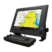
Color Plotter, High-speed and accurate display of charts
Brand:
JRC
| Category:
Plotter
| Size: 0.31 MB
JRC JLZ-1000 Simple Operation Manual (2 pages)
Color Plotter
Brand:
JRC
| Category:
Plotter
| Size: 0.72 MB
Advertisement
Advertisement
Related Products
JRC JMR-5400 Series
JRC JLN-650
JRC JLR-4340
JRC JLN-720
JRC JLN-900
JRC JLR-31
JRC JLR-7900
JRC JLR-7600
JRC JLR-21
JRC JLN-652
JRC Categories
Water Filtration Systems
Marine Radar
Marine Equipment
Radio Parts
Receiver
More JRC Manuals
Login
Sign In
OR
Sign in with Facebook
Sign in with Google
Upload manual
Upload from disk
Upload from URL