Table of Contents
Advertisement
Advertisement
Table of Contents

Subscribe to Our Youtube Channel
Related Manuals for Hemisphere GPS V104s


Summary of Contents for Hemisphere GPS V104s
- Page 1 V104s GPS Compass User Guide Part No. 875-0346-0 Rev. A1...
- Page 2 This device complies with part 15 of the FCC Rules. Operation is subject to the following two conditions: (1) This device may not cause harmful interference, and (2) this device must accept any interference received, including interference that may cause undesired operation. Copyright Notice Copyright Hemisphere GNSS, Inc.
- Page 3 Documentation Feedback Hemisphere GNSS is committed to the quality and continuous improvement of our products and services. We urge you to provide Hemisphere GNSS with any feedback regarding this guide by writing to the following email address: techsupport@hemispheregnss.com.
-
Page 4: Table Of Contents
V104s Dimensions........ - Page 5 V104s Overview........
- Page 6 V104s GPS Compass User Guide Chapter 1: Introduction Overview Parts List...
-
Page 7: Overview
Crescent and Crescent Vector™ II technology. The V104s is a complete GPS compass and position system in a single enclosure that requires only one power/data cable connection. With its serial support and ease of installation, the V104s is the perfect solution for marine-based applications. -
Page 8: Parts List
The GPS Technical Reference is available from the Hemisphere GNSS website at www.hemispheregnss.com. Parts List Note: The V104s’ parts comply with IEC 60945 Section 4.4: “exposed to the weather. ” The V104s GPS Compass and the power/data cable (accessory item) are the... - Page 9 Chapter 1: Introduction...
-
Page 10: V104S Installation
V104s GPS Compass User Guide Chapter 2: V104s Installation Mounting Location Mounting Orientation Mounting Options Powering the V104s Connecting the V104s to External Devices... -
Page 11: Mounting Location
When considering where to mount the V104s, consider the following GPS reception recommendations: • Ensure there is a clear view of the sky available to the V104s so the GPS and SBAS satellites are not masked by obstructions that may reduce system performance. -
Page 12: Vhf Interference
Follow VHF radio manufacturers’ recommendations on how to mount their radios and what devices to keep a safe distance away. • Hand-held 5W VHF radios may not provide suitable filtering and may interfere with the V104s’s operation if too close. - Page 13 Chapter 2: Installation Before installing the V104s use the following diagram to ensure there are no nearby devices that may cause VHF interference. VHF Antenna 1.5 m radius at top (minimum) Use these minimum distances to determine where to place the V104s 1.0 m radius at base...
-
Page 14: Mounting Orientation
This provides a true heading. In this orientation: • If you use a gyrocompass, you can enter a heading bias in the V104s to calibrate the physical heading to the true heading of the vessel. •... - Page 15 Chapter 2: Installation Figure 2-2 and Figure 2-3 provide mounting orientation examples. Forward motion Recessed arrow located on bottom of enclosure Figure 2-2: Recommended orientation and resulting signs of HPR values Recessed arrow located on bottom of enclosure Forward motion Figure 2-3: Alternate orientation and resulting signs of HPR values...
-
Page 16: V104S Alignment
Figure 2-5: Long sight alignment center post If you have another accurate source of heading data on your vessel, such as a gyrocompass, you may use its data to correct for a bias in V104s alignment within the V104s software configuration (PocketMax or VectorPC). -
Page 17: Mounting Options
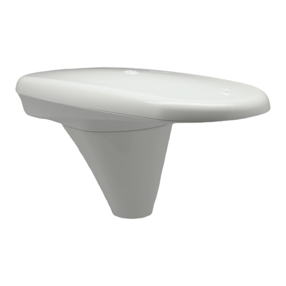
Chapter 2: Installation Mounting Options The V104s allows for both pole or flush mounting. Follow directions below for detailed mounting directions. V104s Dimensions Figure 2-6 illustrates the physical dimensions of the V104s. Figure 2-6: V104s dimensions... - Page 18 V104s GPS Compass User Guide V104s dimensions with adapter...
-
Page 19: Power/Data Cable Considerations
Do not crimp or excessively bend the cable • Avoid placing tension on the cable • Remove unwanted slack from the cable at the V104s end • Secure along the cable route using plastic wraps Improperly installed cable near machinery can be dangerous... -
Page 20: Flush Mount
V104s GPS Compass User Guide Flush Mount The bottom of the V104s contains two holes for flush mounting the unit to a flat surface (Figure 2-7). The flat surface may be something you fabricate per your installation, an off-the-shelf item (such as a radar mounting plate), or an existing surface on your vessel. - Page 21 V104s and through the mounting surface. Use two M6 washers and M6 nuts to secure the V104s to the mounting plate (washers and nuts not included). When installing the V104s, hand tighten only. Damage resulting from over-tightening is not covered by the warranty.
-
Page 22: Pole Mount
Pole Mount Before pole mounting the V104s • V104s provides roll measurements when mounted in any preferred orientation. If accurate roll measurements are important to your use case, we recommend mounting the V104s perpendicular to the vessel’s axis. If roll measurements are less important, install the V104s parallel with the vessel’s axis. - Page 23 V104s unit. Use 5 mm Allen key to fasten two M6 screws to secure V104s onto adapter. Use 15 in-lb torque...
- Page 24 V104s unit. Use 5 mm Allen key to fasten two M6 screws to secure V104s onto adapter. Use 15 in-lb torque...
- Page 25 Key-way alignment Rotate the cable ring clockwise until it locks. The locking action is firm, but you will feel a positive “click” when it has locked. Note: See “V104s Dimensions” on page 12 for information on routing the power/data cable.
-
Page 26: Powering The V104S
See Table B-3 on page 47 for complete power specifications. Connecting to a Power Source Before you power up the V104s you must terminate the wires of the power cable as required. There are a variety of power connectors and terminals on the market from which to choose, depending on your specific requirements. -
Page 27: Connecting The V104S To External Devices
Connecting the V104s to External Devices Power/Data Cable Considerations The V104s uses a single 15 m (49 ft) cable for power and data input/output. Figure 2-8: Power/data cable, 15 m The receiver end of the cable is terminated with an environmentally sealed 12-pin connection while the opposite end is unterminated and requires field stripping and tinning. -
Page 28: Power/Data Cable Pin-Out Specifications
V104s GPS Compass User Guide Power/Data Cable Pin-out Specifications Figure 2-9 show the power/data cable pin-out, while Table 2-1 shows the cable’s pin-out specifications. Figure 2-9: Power/data cable pin assignment Table 2-1: Power/data cable pin-out Function Wire Color CH-GND Drain... -
Page 29: Serial Ports
A personal computer (PC) typically uses a DB9-male connector for RS-232 serial port communications. Note: For successful communications use the 8-N-1 protocol and set the baud rate of the V104s’s serial ports to match that of the devices to which they are connected. Flow control is not supported. -
Page 30: Default Parameters
Table 2-2 and Table 2-3 provide details on the default port settings, available baud rates, differential age, elevation mask, and default differential mode. Note: Use the $JSAVE command to save changes you make to the V104s’s configuration for the changes to be present in subsequent power cycles. - Page 31 Chapter 2: Installation...
- Page 32 V104s GPS Compass User Guide Chapter 3: Operation GPS Overview V104s Overview Common Commands and Messages...
-
Page 33: Gps Overview
Receiver Performance The V104s works by finding four or more GPS satellites in the visible sky. It uses information from the satellites to compute a position within 3 m. Since there is some error in the GPS data calculations, the V104s also tracks a differential correction. -
Page 34: Differential Operation
Autonomous position capabilities of the V104s will result in position accuracies of 3 m 95% of the time. In order to improve position quality to better than 1.0 m 95%, the V104s is able to use differential corrections received through the internal SBAS demodulator or externally-supplied RTCM corrections. -
Page 35: V104S Overview
V104s Overview The V104s provides accurate and reliable heading and position information at high update rates. To accomplish this task, the V104s uses a high performance GPS receiver and two antennas for GPS signal processing. One antenna is designated as the primary GPS antenna and the other is the secondary GPS antenna. -
Page 36: Supplemental Sensors
V104s GPS Compass User Guide Supplemental Sensors The V104s has an integrated gyro and two tilt sensors. The gyro and tilt sensors are enabled by default. Both supplemental sensors are mounted on the printed circuit board inside the V104s. The sensors act to reduce the search volume, which improves heading startup and reacquisition times. - Page 37 The V104s’ accelerometers (internal tilt sensors) are factory-calibrated and enabled by default. This improves heading solution beyond the volume associated with just a fixed antenna separation. This is because the V104s knows the approximate inclination of the secondary antenna with respect to the primary antenna.
- Page 38 1º per minute for up to three minutes, in times of GPS loss for either antenna. If the outage lasts longer than three minutes, the gyro will have drifted too far and the V104s begins outputting null fields in the heading output messages. There is no user control over the timeout period of the gyro.
-
Page 39: Time Constants
Chapter 3: Operation Time Constants The V104s incorporates user-configurable time constants that can provide a degree of smoothing to the heading, pitch, rate of turn (ROT), course over ground (COG), and speed measurements. You can adjust these parameters depending on the expected dynamics of the vessel. For example, increasing the time is reasonable if the vessel is very large and is not able to turn quickly or would not pitch quickly. -
Page 40: Watchdog
V104s GPS Compass User Guide Course Over Ground (COG) time constant: Use the $JATT,COGTAU command to adjust the level of responsiveness of the COG measurement provided in the $GPVTG message. The default value of this constant is 0.0 seconds of smoothing. Increasing the time constant increases the level of COG smoothing. -
Page 41: Common Commands And Messages
Hemisphere GNSS website at www.hemispheregnss.com. Table 3-2 below through Table 3-4 provide brief descriptions of common commands and messages for the V104s. Refer to the Hemisphere GNSS’ GPS Technical Reference for more detailed information. Table 3-2: Commands... - Page 42 V104s GPS Compass User Guide In Table 3-3 the Info Type value is one of the following: • P = Position • V = Velocity, Time • H = Heading, Attitude • S = Sats, Stats, Quality Table 3-3: NMEA 0183 and other messages...
- Page 43 Chapter 3: Operation Table 3-3: NMEA 0183 and other messages ( continued) Info Message Description Approved Type Message $GPRRE Range residual and estimated position error $GPVTG COG and ground speed $GPZDA Time and date $PASHR Time, heading, roll, and pitch data in one message $PSAT,GBS Satellite fault detection (RAIM)
- Page 44 V104s GPS Compass User Guide Table 3-4: Binary messages $JBIN Description Message GPS position GPS DOPs SBAS SBAS ephemeris data Ionosphere and UTC conversion parameters Satellite ephemeris data Code and carrier phase Processor statistics Satellites and almanac GPS diagnostics Table 3-5: Parameters specific to $JATT command...
- Page 45 Chapter 3: Operation Table 3-5: Parameters specific to $JATT command ( continued) Parameter Description Query Specify HTAU Set/query heading time constant (0.0 to 3600.0 sec) Note: Higher HTAU values combined with disabling the gyro will result in significant lag time LEVEL Enable/disable level operation MSEP...
-
Page 46: Appendix A Troubleshooting
V104s GPS Compass User Guide Appendix A: Troubleshooting... - Page 47 Verify desired messages are activated (using PocketMax, Vector PC or $JSHOW in any terminal program) • Ensure the baud rate of the V104s matches that of the receiving device • Check integrity and connectivity of power and data cable connections Random data from •...
- Page 48 Table A-1: Troubleshooting ( continued) Symptom Possible Solution No SBAS lock • Verify the V104s has a clear view of the sky • Verify the lock status of SBAS satellites (this can be done with PocketMax - monitor BER value) •...
- Page 49 Appendix A: Troubleshooting Table A-1: Troubleshooting ( continued) Symptom Possible Solution No DGPS position in • Verify the baud rate of the RTCM input port external RTCM mode matches the baud rate of the external source • Verify the pin-out between the RTCM source and the RTCM input port (transmit from the source must go to receive of the RTCM input port and grounds must be connected)
-
Page 50: Appendix B Specifications
V104s GPS Compass User Guide Appendix B: Specifications... - Page 51 Appendix B: Specifications Table B-1 through Table B-5 provide the V104s’s GPS sensor, communication, power, mechanical, and environmental specifications. Table B-1: GPS sensor specifications Item Specification Receiver type Vector GPS L1 Compass Channels Two 12-channel, parallel tracking (Two 10-channel when tracking SBAS)
- Page 52 V104s GPS Compass User Guide Table B-2: Communication specifications Item Specification Serial ports 2 full-duplex RS-232 Baud rates 4800, 9600, 19200, 38400, 57600, 115200 Correction I/O protocol RTCM SC-104 Data I/O protocol NMEA 0183, Crescent binary Table B-3: Power specifications...
- Page 53 Appendix B: Specifications Table B-5: Environmental specifications Item Specification Operating temperature -30°C to +70°C (-22°F to +158°F) Storage temperature ° ° ° ° C to +85 C (-40 F to +185 Water and Dust IP69 Humidity 100% non-condensing Vibration IEC 60945 CE (IEC 60945 Emissions and Immunity) FCC Part 15, Subpart B CISPR22...
- Page 54 V104s GPS Compass User Guide Index automatic tracking 28 operation 28 alarm overview 28 watchdog 35 receiver performance 28 alignment 11 reception 6 automatic sensor specifications 46 SBAS tracking 29 gyro aiding 32 tracking 28 heading time constant 34 cable See power/data cable 14...
- Page 55 Index HRTAU 34 HTAU 34 orientation for mounting 9 PTAU 34 SPDTAU 35 tracking parallel mounting 9 automatic 28 part numbers 3 automatic SBAS 29 parts list 3 troubleshooting 42 perpendicular mounting 9 pitch time constant 34 pole mount 17 VHF interference 7 power connecting to a power source 21...
-
Page 56: End User License Agreement
End User License Agreement IMPORTANT - This is an agreement (the "Agreement") between you, the end purchaser ("Licensee") and Hemisphere GNSS Inc. ("Hemisphere") which permits Licensee to use the Hemisphere software (the "Software") that accompanies this Agreement. This Software may be licensed on a standalone basis or may be embedded in a Product. Please read and ensure that you understand this Agreement before installing or using the Software Update or using a Product. - Page 57 WARRANTY DISCLAIMER. EXCEPT AS EXPRESSLY SET OUT IN THIS AGREEMENT, HEMISPHERE MAKES NO REPRESENTATION, WARRANTY OR CONDITION OF ANY KIND TO LICENSEE, WHETHER VERBAL OR WRITTEN AND HEREBY DISCLAIMS ALL REPRESENTATIONS, WARRANTIES AND CONDITIONS OF ANY KIND INCLUDING FITNESS FOR A PARTICULAR PURPOSE, MERCHANTABILITY, ACCURACY, RELIABILITY OR THAT THE USE OF THE SOFTWARE WILL BE UNINTERRUPTED OR ERROR-FREE AND HEREBY DISCLAIMS ALL REPRESENTATIONS, WARRANTIES AND CONDITIONS ARISING AS A RESULT OF CUSTOM, USAGE OR TRADE AND THOSE ARISING UNDER STATUTE.
- Page 58 Hemisphere or termination by Licensee, Licensee shall at the end of any notice period (a) cease using the Software; and (b) return to Hemisphere (or destroy and provide a certificate of a Senior Officer attesting to such destruction) the Software and all related material and any magnetic or optical media provided to Licensee.
-
Page 59: Warranty Notice
Warranty Notice COVERED PRODUCTS: This warranty covers all products manufactured by Hemisphere GNSS and purchased by the end purchaser (the "Products"), unless otherwise specifically and expressly agreed in writing by Hemisphere GNSS. LIMITED WARRANTY: Hemisphere GNSS warrants solely to the end purchaser of the Products, subject to the exclusions and procedures set forth below, that the Products sold to such end purchaser and its internal components shall be free, under normal use and maintenance, from defects in materials, and workmanship and will substantially conform to Hemisphere GNSS’s applicable specifications for the Product, for a period of 12 months from delivery of such Product to such end purchaser (the ”Warranty Period”).
Need help?
Do you have a question about the V104s and is the answer not in the manual?
Questions and answers