Table of Contents
Advertisement
Quick Links
Advertisement
Table of Contents

Related Manuals for Garmin Astro 320 with T5


Summary of Contents for Garmin Astro 320 with T5
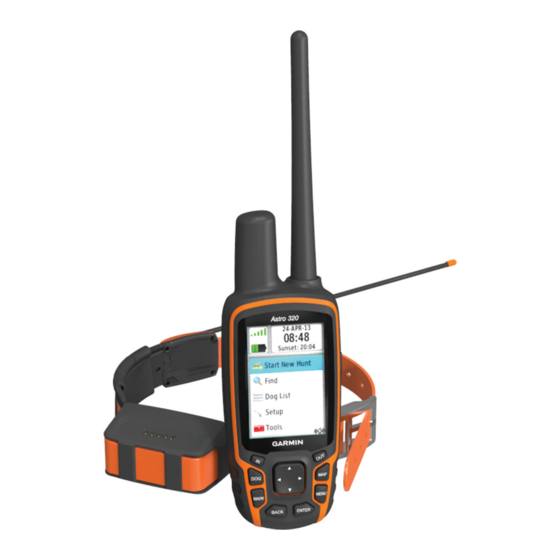
- Page 1 Astro 320 with T5 ® Owner’s Manual June 2014 190-01772-00_0A Printed in Taiwan...
- Page 2 Garmin ® , the Garmin logo, Astro ® , BlueChart ® , City Navigator ® , and TracBack ® are trademarks of Garmin Ltd. or its subsidiaries, registered in the USA and other countries.
-
Page 3: Table Of Contents
Table of Contents Archiving a Track Manually ........... 6 Sending and Receiving Data Wirelessly ........6 Sharing Dog Information ............6 Introduction..............1 Receiving Dog Information ............ 6 Setting Up the System ............... 1 Navigation...............6 Device Overviews ..............1 Astro 320 Handheld Device ..........1 Map .................... - Page 4 Cleaning the Device ............11 Cleaning the Screen ............11 Specifications - Astro ............... 11 T5 Dog Collar Device Specifications ........11 Battery Information ..............11 Long-Term Storage ............. 11 Data Management ..............11 File Types ................11 Installing a Memory Card ............ 11 Connecting the Handheld Device to a Computer ....
-
Page 5: Installing Batteries
Introduction Keypad WARNING See the Important Safety and Product Information guide in the product box for product warnings and other important information. Setting Up the System You must set up the handheld device and the dog collar device before you can use the devices. Install batteries in the handheld device (Installing Batteries). -
Page 6: Adjusting The Backlight Brightness
shows the GPS signal strength. When the collar has acquired satellite signals, the status LED flashes a double-blink or triple-blink in green. Adjusting the Backlight Brightness NOTE: The backlight brightness may be limited when the battery strength is low. Extensive use of screen backlighting can significantly reduce battery life. -
Page 7: Navigating To Your Dog
Select MAP. Select Dog List. Select IN and OUT to zoom in and out of the map. Select a dog. Select Show Info. Navigating to Your Dog Select the colored square next to the dog’s name. Select Dog List. Select a color. Select the dog. -
Page 8: Activating Collar Lock
Before you can track your dogs and contacts using BaseCamp, From the main menu, select Tools > Waypoint Mgr.. you must download BaseCamp to your computer (www.garmin.com/basecamp). Select a waypoint. The BaseStation feature of BaseCamp allows you to track your Select MENU >... -
Page 9: Deleting All Routes
Move to the waypoint location. Select Reverse Route. Select Start. Deleting a Route Follow the on-screen instructions. Select Tools > Route Planner. When the confidence status bar reaches 100%, select Save. Select a route. For best results, collect 4 to 8 samples for the waypoint, waiting Select Delete Route >... -
Page 10: Calibrating The Compass
Sending and Receiving Data Wirelessly While navigating to a destination, select Tools > Compass Before you can share data wirelessly, you must be within 10 feet (3 m) of a compatible Garmin ® device. Turn until points toward the top of the compass, and continue moving in that direction to the destination. -
Page 11: Trip Computer
Applications Finding a Waypoint Near Another Waypoint From the main menu, select Tools > Waypoint Mgr.. Select a waypoint. Setting a Proximity Alarm Select MENU > Find Near Here. Proximity alarms alert you when you or your dogs are within a specified range of a particular location. -
Page 12: Simulating A Location
From the dog tracking page, select a dog. A chirp is a small Garmin accessory that is programmed and left The dog information page appears. in a geocache. You can use your device to find a chirp in a Select MENU >... -
Page 13: Setting The Device Tones
Overlay Service), or Demo Mode (GPS off). For more level is higher than the selected level. information about WAAS, go to www.garmin.com/aboutGPS Text Size: Selects the text size for map items. /waas.html. Detail: Selects the amount of detail shown on the map. -
Page 14: Time Settings
Select Setup > Time. Program chirp: Programs the chirp accessory. See the chirp Time Format: Sets the device to show time in a 12-hour or 24- owner's manual at www.garmin.com. hour format. Time Zone: Sets the time zone for the device. Automatic sets Routing Settings the time zone automatically based on your GPS position. -
Page 15: Cleaning The Device
• GPX geocache files. Go to www.opencaching.com. Alkaline battery life Up to 15 hr., typical usage • GPI custom POI files from the Garmin POI Loader. Go to NiMH or lithium battery life Up to 20 hr., typical usage www.garmin.com/products/poiloader. -
Page 16: Connecting The Handheld Device To A Computer
Deleting Files accessories. NOTICE • Bring the Garmin device within range 3 m (10 ft.) of the ANT+ accessory. If you do not know the purpose of a file, do not delete it. Your device memory contains important system files that should not •... -
Page 17: Dog Device Battery Replacement Instructions
• When paired, your Garmin device receives data from only your accessory, and you can go near other accessories. Dog Device Battery Replacement Instructions T5 Components Replace the battery cover. Replace the screws to secure the battery cover. Connect the battery connector and power connector. -
Page 18: Changing The Fuse In The Vehicle Power Cable
Battery Level: The remaining battery power. Bearing: The direction from your current location to a destination. You must be navigating for this data to appear. Cadence: The revolutions of the crank arm or strides per minute. Your device must be connected to a cadence accessory. -
Page 19: Troubleshooting
You should position the device near the dog's vocal cords or tighten the dog collar device (Fitting the Collar on Your Dog). Getting More Information You can find more information about this product on the Garmin website. Appendix... -
Page 20: Index
Index TracBack 6 tracks 3, 5, 6 geocaches 7, 8 navigating 6 downloading 7 recording 5 settings 10 accessories 12, 15 saving 5 GPS 8 adding a dog 3 settings 9 settings 9 alarms transferring clock 7 files 11 marine 10 hunting and fishing times 7 tracks 12 proximity 7 transferring files 7 tones 9 trip information icons 3 alerts, dog 3 resetting 7 almanac 7 viewing 7 altimeter 10... - Page 22 +27 (0)11 251 9999 + 46 7744 52020 +886 2 2642-9199 ext 2 +49 (0)180 6 427646 0808 238 0000 20 ct./Anruf. a. d. +44 (0) 870 8501242 deutschen Festnetz, Mobilfunk max. 60 ct./Anruf 913-397-8200 1-800-800-1020 © 2014 Garmin Ltd. or its subsidiaries...
Need help?
Do you have a question about the Astro 320 with T5 and is the answer not in the manual?
Questions and answers