Garmin Alpha 100 Owner's Manual
With t5
Hide thumbs
Also See for Alpha 100:
- Owner's manual (27 pages) ,
- Product information (4 pages) ,
- Quick reference (2 pages)
Table of Contents
Advertisement
Quick Links
Advertisement
Table of Contents

Related Manuals for Garmin Alpha 100


Summary of Contents for Garmin Alpha 100
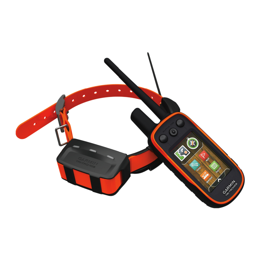
- Page 1 Alpha 100 with T5 ® Owner’s Manual June 2014 190-01771-00_0A Printed in Taiwan...
- Page 2 Garmin ® , the Garmin logo, Alpha ® , BlueChart ® , and City Navigator ® are trademarks of Garmin Ltd. or its subsidiaries, registered in the USA and other countries.
-
Page 3: Table Of Contents
Setting Up the Alpha System ............. 1 Device Overviews ..............1 Waypoints .................. 7 Alpha 100 Handheld Device ..........1 Marking Your Current Location ..........7 T5 Dog Collar Device ............1 Marking a Waypoint Using the Map ........7 Getting More Information ............ - Page 4 Device Care ................13 Cleaning the Device ............13 Cleaning the Touchscreen ..........13 Specifications ................13 Alpha 100 Handheld Device Specifications ......13 T5 Dog Collar Device Specifications ........13 Battery Information ..............13 Long-Term Storage ............. 13 Maximizing the Battery Life ..........13 Saving Energy While Charging the Device ......
-
Page 5: Getting Started
Signals). • Go to www.garmin.com/learningcenter. Attach the collar (Fitting the Collar on Your Dog). • Go to http://buy.garmin.com, or contact your Garmin dealer for information about optional accessories and replacement Device Overviews parts. Alpha 100 Handheld Device Registering Your Device Help us better support you by completing our online registration today. -
Page 6: Charging The Handheld Device
Charging the Handheld Device • On the dog collar device, hold the power key until the status LED flashes and the collar beeps. NOTICE Turning Off the Devices To prevent corrosion, thoroughly dry the USB port, the weather • On the handheld device, hold the power key until the cap, and the surrounding area before charging or connecting to LCD display turns off. -
Page 7: Vhf Radio Information
See the product Select Dog List. packaging or go to www.garmin.com/tracking-legal for details about the radio frequency of this product. Select a dog. Select Show Info > Reset > Yes. -
Page 8: Setting Dog Alerts
If you are experiencing interference from other collars or automatically. After bark detection is enabled, you can set up a handheld devices in the area, you might need to change the ID bark alert (Setting Dog Alerts). for the dog. Communication with the Collar Select Dog List. -
Page 9: Dog Status Icons
Before you can track your dogs and contacts using BaseCamp, Dog Training you must download BaseCamp to your computer (www.garmin.com/basecamp). You should research and investigate the training methods best suited for you, your dog, and your needs. This manual provides... -
Page 10: Training Methods
Training Methods Bring the two handheld devices near each other, and select Yes on your handheld device. NOTE: Training features are not available in all areas for On the contact's handheld device, select > Contacts > tracking collars. Pair. Tone: Activates an audible tone instead of stimulation. A tone On your handheld device, enter the name of the contact, and can be used as either a positive or negative training cue, select... -
Page 11: Changing Your Contact Id
Changing Your Contact ID Select Show Info. Select > Adjust Collar Light. If you are experiencing interference from other collars or handheld devices in the area, you might need to change the Select Continuous, Blink Slow, or Blink Fast. contact ID for your handheld device. TIP: Select different light setting for each dog to help you Select Setup >... -
Page 12: Increasing The Accuracy Of A Waypoint Location
Increasing the Accuracy of a Waypoint Location • To view the point on the map, select Review. You can refine a waypoint location for more accuracy. When • To change the order of the points on the route, select averaging, the device takes several readings at the same Move Up or Move Down. -
Page 13: Navigating To The Start Of A Track
Setup Heading > Go To Line/Pointer > Course (CDI). Select an option. Sending and Receiving Data Wirelessly Before you can share data wirelessly, you must be within 10 feet (3 m) of a compatible Garmin device. You can share waypoints, geocaches, routes, and tracks wirelessly. Select >... -
Page 14: Where To? Menu
course. The scale refers to the distance between dots Trip Computer the course deviation indicator, which tell you how far off course The trip computer displays your current speed, average speed, you are. maximum speed, trip odometer, and other helpful statistics. You can customize the trip computer layout, dashboard, and data Where To? Menu fields... -
Page 15: Changing The Satellite View
Augmentation System/European Geostationary Navigation Select > Satellite > > Use With GPS Off. Overlay Service), or Demo Mode (GPS off). For more information about WAAS, go to http://www.garmin.com Simulating a Location /aboutGPS/waas.html. Select > Satellite > > Use With GPS Off. -
Page 16: Setting The Device Tones
Day Highlight Color: Sets the color for selections made when Activity: Sets an activity for routing. The device calculates in day mode. routes optimized for the type of activity you are doing. Night Highlight Color: Sets the color for selections made when Route Transitions: Sets how the device routes from one point in night mode. -
Page 17: Marine Map Settings
Records elevation changes over a period of time or Specifications distance, records barometric pressure over a period of time, Alpha 100 Handheld Device Specifications or records ambient pressure changes over a period of time. Calibrate Altimeter: Calibrates the altimeter. -
Page 18: Saving Energy While Charging The Device
• GPX geocache files. Go to www.opencaching.com. You can select a longer duration for the update rate to conserve • GPI custom POI files from the Garmin POI Loader. Go to battery power. www.garmin.com/products/poiloader. -
Page 19: Connecting The Handheld Device To A Computer
10 m (32.9 ft.) away from other ANT+ BaseCamp recognizes and transfers the collar's internal accessories. track log. • Bring the Garmin device within range 3 m (10 ft.) of the ANT+ accessory. Deleting Files • After you pair the first time, your Garmin device automatically NOTICE recognizes the ANT+ accessory each time it is activated. -
Page 20: T5 Battery Replacement Instructions
T5 Battery Replacement Instructions T5 Components Replace the battery cover. Replace the screws to secure the battery cover. Connect the battery connector and power connector. You may need to use a flat screwdriver to help secure the connectors. Select the power key to test the connections. When properly connected, a tone is emitted and the status LED blinks green. -
Page 21: Changing The Fuse In The Vehicle Power Cable
Ascent - Total: The total elevation distance ascended since the last reset. Barometer: The calibrated current pressure. Battery Level: The remaining battery power. Bearing: The direction from your current location to a destination. You must be navigating for this data to appear. Cadence: The revolutions of the crank arm or strides per minute. - Page 22 Speed - Overall Avg.: The average speed while moving and stopped since the last reset. Sunrise: The time of sunrise based on your GPS position. Sunset: The time of sunset based on your GPS position. Time of Day: The current time of day based on your current location and time settings (format, time zone, daylight saving time).
-
Page 23: Index
Index statistics 3 track and train codes 3 satellite signals 10, 11 tracking 4, 5 acquiring 2 tracks 3, 15 screen accessories 1, 15 training 6 locking 2 alarms training basics 5 settings 11 clock 10 type 3 settings 11–13 marine 13 update rate 14 sharing data 9 proximity 10 Sight 'N Go 10 tones 12 software, updating 13 alerts 6 elevation 8, 10 specifications 13 dog 4 plot 10... - Page 24 +27 (0)11 251 9999 + 46 7744 52020 +886 2 2642-9199 ext 2 +49 (0)180 6 427646 0808 238 0000 20 ct./Anruf. a. d. +44 (0) 870 8501242 deutschen Festnetz, Mobilfunk max. 60 ct./Anruf 913-397-8200 1-800-800-1020 © 2014 Garmin Ltd. or its subsidiaries...
Need help?
Do you have a question about the Alpha 100 and is the answer not in the manual?
Questions and answers