Garmin GDL 30A Owner's Manual
Marine weather satellite receiver
Hide thumbs
Also See for GDL 30A:
- Owner's manual (34 pages) ,
- Installation instructions manual (8 pages) ,
- Owner's manual (38 pages)
Table of Contents
Advertisement
Quick Links
Advertisement
Table of Contents

Related Manuals for Garmin GDL 30A


Summary of Contents for Garmin GDL 30A
- Page 1 GDL 30/ GDL 30A (audio) marine weather satellite receiver owner’s manual...
- Page 2 All rights reserved. Except as expressly provided herein, no part of this manual may be reproduced, copied, transmitted, disseminated, downloaded or stored in any stor- age medium, for any purpose without the express prior written consent of Garmin. Garmin hereby grants permission to download a single copy of this manual and of any...
-
Page 3: Preface
GDL 30/30A. This manual discusses in detail how to install keep your original sales receipt in a safe place or your GDL 30/30A as well as how to subscribe to XM WX Weather (and XM Radio if you own a GDL 30A). It attach a photocopy inside the manual. -
Page 4: Table Of Contents
Subscribing to XM WX Weather and XM Radio ....6 Finding Weather Conditions at other Locations....23 To properly install your Marine Weather Customizing Radio Stations (for GDL 30A only)....24 Adding Weather and Sea Surface Features to your Map Satellite Receiver or Marine Weather/Audio displays................ -
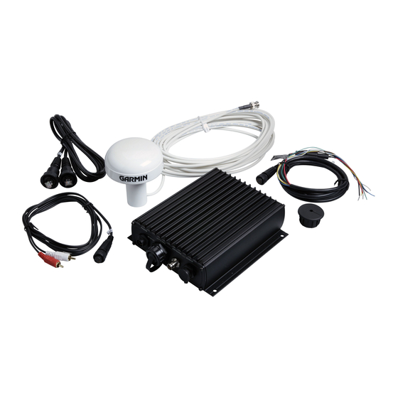
Page 5: Unit Overview
• 7-pin power cable • Garmin marine network cables (20 ft and 40 ft) any way voids your warranty and may result in permanent damage to the equipment. -
Page 6: Installing The Gdl 30/30A
Simply align the cable heads with the opening of the network port on both the GDL 30/30A and the Using the Grommet Chartplotter. Do not cut the Garmin marine network cable if you need to drill a hole in your boat; use the included grommet that is specially designed to cover holes that are drilled for the the included grommet that is specially designed to cover holes that are drilled for the Garmin marine network cable. - Page 7 (see Appendix A to view the blink codes). Do not cut the GA 31 cable under any circumstance. You are now ready to subscribe to XM WX Weather (and XM Radio if you have a GDL 30A). Subscription instructions begin on the following page.
-
Page 8: Subscribing To Xm Wx Weather And Xm Radio
After you have completed installing the GDL 30/30A, you are ready to notify XM Satellite Radio to activate and XM Radio your XM WX weather subscription service. If you own a GDL 30A, you also can activate the XM Radio sub- scription service. - Page 9 If you have a GDL 30A (Weather/Audio Satellite Receiver): Subscribing to XM WX Weather In addition to an XM Weather Radio ID, verify that you also have an verify that you also have an XM Audio Radio ID and have this...
- Page 10 When you turn on the GDL 30/30A after completing Step 6 (above), you are ready to add weather fea- tures to your Chartplotter’ s Map page (see page 9). If you have a GDL 30A, you are ready to customize your...
-
Page 11: Adding Weather And Sea Surface Features To Your Map Displays
Adding Weather and Sea Surface Features to your Map displays Adding Weather Data When you add weather and sea surface features, they will appear on the Map function on your Chartplotter. You can add these features through the Map function’ s Adjustment menu. Access this menu by pressing the ADJ/MENU key on your Chartplotter (see your Chartplotter’... -
Page 12: Initially Loading Weather-Related Information
Initially Loading Weather-Related Information Adding Weather Data When you add a weather feature to a map for the first time, data for that feature is sent to your GDL 30/ When you add a weather feature to a map for the fi rst time, data for that feature is sent to your GDL 30/ 30A via XM WX Satellite Radio. -
Page 13: Weather Features
Weather Features Weather Features The following weather features are available along with a brief description of each. Note that the GDL 30/30A merely reports weather; it does not interpret weather data. Weather data that appears for each feature comes from reputable weather data centers such as the National Weather Service and the Hydrometerologi- cal Prediction Center. -
Page 14: Storm Cells
Storm Cells Weather Features The Storm Cells feature displays storms as well as the storm’ s projected path in the immediate future. It also shows the size of the storm cell. The direction of the red cone indicates the projected path of the storm cell. -
Page 15: Lightning
Lightning Weather Features Lightning strikes are represented by lightning bolt icons, as shown in the images below. Lightning appears on the map if strikes have been detected within the last seven minutes. This image displays lightning strikes on a map that also displays NEXRAD, storm cells, and wind. -
Page 16: Wind
Wind Weather Features The Wind feature shown below displays wind speeds and direction. Wind speed is represented by fl ags on a wind arrow, where one big fl ag equals 10 knots and one small fl ag equals 5 knots. A darkened pennant equals 50 knots. -
Page 17: Pressure
Pressure Weather Features The Pressure feature below displays pressure readings in millibars. Isobars on the map show changes in pressure. The closer the isobars are to each other, the faster the change in pressure. Pressure units can be confi gured from the Main Menu page (go to the System tab and then to the Units submenu tab). -
Page 18: Hurricanes
Hurricanes Weather Features The Hurricanes feature shows the current position of a hurricane as well as its projected path (indicated by a red line). The darkened squares that appear (as in the examples in the left-hand column below) along the red line display the projected locations received from the National Hurricane Center. The Center provides four forecasts at 12-hour intervals as well as a fi... -
Page 19: Visibility
Visibility Weather Features Visibility is the maximum horizontal distance that can be seen. Isobars on the Visibility feature show a change in visibility. In the example below, visibility ranges from .5 miles to 3 miles. You can get a general idea of reduced visibil- ity across a wide area when the map view is signifi... -
Page 20: Fronts
Fronts Weather Features The map below shows fronts positions as well as areas of high (H) and low (L) pressure for the United States. Blue fronts indicate cold fronts, red fronts indicate warm fronts, and alternating red and blue fronts indicate stationary fronts. -
Page 21: Sea Surface Features
Sea Surface Features Sea Surface Features Sea Surface features include sea surface temperatures as well as the height, period, and direction of waves. Information provided on these pages come from satellite and buoy data, and ship reports combined with computer models. See the XM WX Satellite Weather Web site at http://weather.xmradio.com/weather/ specifi... -
Page 22: Wave Period
Wave Period Sea Surface Features The Wave Period feature provides the time (in seconds) between successive waves. Wave Direction The Wave Direction feature shows the direction in which a wave is moving, as indicated by the direction of the red arrow. This map displays all four sea surface features. -
Page 23: Viewing Multiple Maps
Viewing Multiple Maps Viewing Features Some Chartplotters can show two map displays simultaneously (see your Chartplotter’ s Owner’ s Manual for confi guration information). This allows you to view weather data on one map display and non-weather- related information on the other. Consider zooming in to a specifi... -
Page 24: Finding Current Weather, Forecast, And Sea Surface Conditions
Finding Current Weather, Forecast, and Sea Surface Conditions Forecast and Current Conditions While you are on the water, check your GDL 30/30A to fi nd current weather conditions, forecast infor- mation, and sea surface information from the weather center that is nearest to your present location or other places you seek. -
Page 25: Finding Weather Conditions At Other Locations
The Sea Surface submenu tab provides weather data of specifi c importance to mariners. This data comes Forecast and Current Conditions from buoys that are nearest to your current location or other locations you specify. Finding Weather Conditions at other Locations When you visit the Current, Forecast, and Sea Surface submenu tabs for the fi... -
Page 26: Customizing Radio Stations (For Gdl 30A Only)
ARROW RIGHT to the Audio submenu tab. If your GDL 30A is properly connected, you will see On in the “Audio Output” box. You will also see a station as well as the current song from that station in the Radio Tuning box. If CHECK ANTENNA appears in the Radio Tuning box, double-check to make certain the GA 31 antenna has been properly installed and that the audio cable is securely connected to your GDL 30A and to your stereo receiver. -
Page 27: Adding Favorites
ARROW DOWN to view the variety of stations. The station name and number, category, current song, Customizing Radio Stations and artist appears. When you see a song you’d like to hear, press the ENTER key again. The Radio Tuning box highlights, indicating that the song has been selected: Category Station number... -
Page 28: Scanning Stations
Periodically, stations may take a few moments to load. In this case, “LOADING” will appear Next, highlight the “Start Scanning” button and press ENTER. The GDL 30A scans stations according to in the Radio Tuning box. your preference. When you settle on a selection, press ENTER to quit the scan and play the currently-dis- played song. -
Page 29: Disabling The Audio Output
Disabling the Audio Output Customizing Radio Stations You can disable the audio output without having to turn off your GDL 30A or disconnect cables. High- light the “Audio Output” box and press ENTER. Highlight Off and then press ENTER. Your sound remains disabled until you repeat the above steps and select On. -
Page 30: Appendix A: Blink Codes
Status: GDL 30/30A is on and is receiving an XM signal. Solid Red (no blink) Status: Software failure - Call Garmin Customer Support. Red blinking, on for 1/10 second, off for 1/10 second (very fast blink) Status: System alarm. The display device gives a message indicating the type of failure. -
Page 31: Appendix B: Broadcast Rates
Weather-Related Broadcast Rates Appendix Feature Broadcast Rates (minutes) NEXRAD Appendix B: Broadcast Rates Storm Cells 1.25 Lightning Wind Pressure Hurricanes Visibility Fronts Sea Surface Temperature Wave Height Wave Period Wave Direction Current Conditions Forecasts Sea Surface Conditions... -
Page 32: Appendix C: Specifi Cations
Data Output on battery power only (engines off) for extended Source: Proprietary Garmin data format. periods of time, be sure there are enough avail- able amperage to run the units for the time period. GA 31 Antenna Physical Specifi cations... -
Page 33: Appendix D: Software
America copyright laws and international copyright treaties. You further acknowledge that the structure, orga- nization and code of the Software are valuable trade secrets of Garmin and that the Software in source code form remains a valuable trade secret of Garmin. You agree not to decompile, disassemble, modify, reverse assemble, reverse engineer or reduce to human readable form the Software or any part thereof or create any derivative works based on the Software. -
Page 34: Appendix E: Product Safety And Regulatory Information
The system is subject to changes which could affect the accuracy and performance of all GPS equipment. Although the Garmin GDL 30/30A is a precision electronic NAVigation AID (NAVAID), any NAVAID can be misused or misinterpreted and, therefore, become unsafe. - Page 35 Map Data Information One of the goals of Garmin is to provide customers with the most complete and accurate cartography that is available to us at a reasonable cost. We use a combination of governmental and private data sources, which we identify as required in product literature and copyright messages displayed to the consumer.
-
Page 36: Limited Warranty
Abbey Park Industrial Estate Garmin retains the exclusive right to repair or replace the unit or software or offer a full refund of the pur- Romsey, SO51 9DL, U.K. -
Page 37: Index
NEXRAD map 11 Weather submenu tab 9 Storm Cells map 12 Weather tab 22 Subscribing to XM Weather/Radio 6 Web Site, Garmin 34 Entering weather fi eld ranges 9 Wind map 14 Packing list 3 Pressure map 15 Temperature map 19... - Page 40 For the latest free software updates (excluding map data) throughout the life of your Garmin products, visit the Garmin Web site at www.garmin.com. © Copyright 2004 Garmin Ltd. or its subsidiaries Garmin International, Inc. 1200 East 151 Street, Olathe, Kansas 66062, U.S.A.
Need help?
Do you have a question about the GDL 30A and is the answer not in the manual?
Questions and answers