Garmin GDL 30A Owner's Manual
Owner's manual
Hide thumbs
Also See for GDL 30A:
- Owner's manual (40 pages) ,
- Installation instructions manual (8 pages) ,
- Owner's manual (38 pages)
Table of Contents
Advertisement
Quick Links
Advertisement
Table of Contents

Related Manuals for Garmin GDL 30A


Summary of Contents for Garmin GDL 30A
- Page 1 ™ owner’s manual...
- Page 2 All rights reserved. Except as expressly provided herein, no part of this manual may be reproduced, copied, transmitted, disseminated, downloaded or stored in any storage medium, for any purpose without the express prior written consent of Garmin. Garmin hereby grants permission to download a single copy of this manual onto a hard drive or other electronic storage medium to be viewed and to print one copy of this manual or of any revision hereto, provided that such electronic or printed copy of this manual must contain the complete text of this copyright notice and provided further that any unauthorized commercial distribution of this manual or any revision hereto is strictly prohibited.
-
Page 3: Introduction
Contact Garmin Contact Garmin if you have any questions while using your GDL 30A. In the USA, contact Garmin Product Support by phone: GDL 30A Owner’s Manual (913) 397-8200 or (800) 800-1020, or go to support. -
Page 4: Table Of Contents
Introduction ...1 Product Registration ... Contact Garmin ... Contact XM ... Important Numbers ... Unit Overview...3 Packing List and Accessories ... Installing and Activating the GDL 30A Using XM WX Weather ...5 Preset Weather Displays ... XM WX Weather Features ...7... -
Page 5: Unit Overview
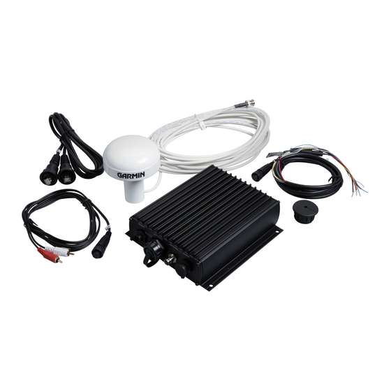
If any parts are missing, contact your Garmin dealer immediately. Standard Package • GDL 30A unit • 7-pin power cable • Garmin Marine Network cable (6 ft.) • GA 32 Antenna with cable • Audio cable Mounting Holes •... -
Page 6: Installing And Activating The Gdl 30A
Step 3: Confirm all components of your service package XM WX Weather: Ensure that the Garmin Marine Network is turned on so you receive the XM signal. When the components of the selected service package appear in the Weather Products list, the XM signal is working correctly. -
Page 7: Using Xm Wx Weather
This manual describes the use of XM WX Weather and XM Audio functions on a GPSMAP 3000 Series chartplotter. If you have a GPSMAP 4000 Series or a GPSMAP 5000 Series chartplotter, please use your chartplotter Owner's Manual for instructions on using XM WX Weather and XM Audio. -
Page 8: Customizing The Preset Weather Displays
Using XM WX Weather Customizing the Preset Weather Displays You can customize the weather displays. Each preset has three subcategories: Precipitation, Atmosphere, and Sea Surface. Each category contains display settings for that topic. You can also change the name of the presets and customize any of the weather features. For detailed information on customizing the preset weather displays, please see the chartplotter Owner’s Manual. -
Page 9: Xm Wx Weather Features
XM WX Weather Features XM WX Weather Features Following is a brief description of each weather feature. The weather features are divided into three subcategories: Precipitation, Atmosphere, and Sea State. Precipitation The Precipitation category provides NEXRAD/Cloud Top, Storm NEXRAD Cell, Lightning, and Hurricane data. Each feature can be turned on or off, or set to display at a selected zoom range. -
Page 10: Cloud Tops
XM WX Weather Features Cloud Tops Cloud Tops are shown in shades of gray. Cloud Tops can be displayed independently or with NEXRAD information. Cloud Tops Legend Cloud Tops Cloud Tops with NEXRAD GDL 30A Owner’s Manual... -
Page 11: Storm Cells
XM WX Weather Features Storm Cells The Storm Cells feature displays storm cells and the projected path of storms in the immediate future. The direction the red cone is pointing (from the narrow end to the wide end) indicates the projected path of the storm cell. The red bars that span the cone indicate the projected area of the storm. - Page 12 XM WX Weather Features Lightning Lightning strikes are represented by lightning-bolt icons, as shown in the images below. Lightning strikes appear on the map if they have been detected within the last seven minutes. The ground-based detection network only detects cloud-to-ground lightning. Cloud Tops with NEXRAD Cloud Tops GDL 30A Owner’s Manual...
- Page 13 Hurricanes The Hurricanes feature shows the current position of a hurricane, tropical storm, or tropical depression, as well as its projected path (indicated by a red line). The darkened squares that appear along the red line indicate the projected locations received from the National Hurricane Center. The Center provides four forecasts at 12-hour intervals and a fifth forecast at a 24-hour interval.
-
Page 14: Atmosphere
Atmosphere The Atmosphere category provides Wind, Pressure, Visibility, Front, and City Condition data. Each feature can be turned on or off, or set to appear at a selected zoom range. Wind The Wind feature displays wind speed and wind direction. Wind direction is indicated by a circle with a wind barb. The circle points in the direction of the wind with the barb as a tail. - Page 15 XM WX Weather Features Pressure The pressure feature displays pressure isobars and pressure centers on the map. The isobars connect points of equal pressure. Pressure readings can help determine weather and wind conditions in an area. High-pressure areas are generally associated with fair weather. Low-pressure areas are generally associated with clouds and the chance of precipitation.
- Page 16 Visibility Visibility is the maximum horizontal distance that can be seen. Isobars on the Visibility feature show a change in visibility. Distance can be displayed in nautical miles (nm), miles (mi.), or kilometers (km). See the chartplotter’s Owner’s Manual for more information on configuring units of measure.
- Page 17 Fronts The Fronts feature displays the lines indicating the leading edge of an air mass that is replacing an existing air mass. This feature also displays pressure centers. Pressure centers are represented by a large red “L” for low-pressure centers or a large blue “H” for high-pressure centers. Pressure centers represent an area where pressure is measured to be either the highest or the lowest pressure relative to the surrounding area.
- Page 18 City Conditions This feature displays the current weather conditions at selected cities throughout North America. The current weather condition for an area is depicted by an icon. City Condition Icons Sunny Partly Cloudy Cloudy Thunderstorms Rain Snow Windy Smoke Foggy City Conditions GDL 30A Owner’s Manual...
-
Page 19: Sea Surface
XM WX Weather Features Sea Surface The Sea Surface category contains Temperature, Wave Height, Wave Period, and Wave Direction. Each feature can be turned on or off, or set to display at a selected zoom range. For more information on configuring units of measure for Temperature and Wave Height, see the chartplotter Owner’s Manual. -
Page 20: Wave Direction
XM WX Weather Features Wave Period The Wave Period feature provides the time (in seconds) between successive waves. Wave Direction The Wave Direction feature shows the direction in which waves are moving, as indicated by the direction of the red arrows. Wave Period Feature Wave Direction Feature GDL 30A Owner’s Manual... -
Page 21: Weather Tab
The Main Menu allows you to customize the weather data that appears on your GPSMAP 3000 Series chartplotter. For information on configuring weather on a GPSMAP 4000 Series or a GPSMAP 5000 Series chartplotter, consult your GPSMAP 4000 Series or GPSMAP 5000 Series chartplotter Owner’s Manual. - Page 22 Forecast The Forecast sub tab includes two panels that display forecast information for the location selected in the Current sub tab. The top panel displays the high/low temperature, chance of precipitation, and weather condition (cloudy, sunny, thunderstorms). The number of days that appear in this panel depend on the data available from the responding weather service center.
- Page 23 Main Menu Sea Surface The Sea Surface sub tab provides weather data of specific importance to mariners. This data comes from a variety of data sources that are nearest to your current or selected location. If a condition field is empty, data for that condition is not currently available. GDL 30A Owner’s Manual...
-
Page 24: Forecast Map
Main Menu Forecast Map The Forecast Map sub tab displays Fronts, High-Pressure and Low-Pressure Centers, and City Conditions. The map zoom range can be changed using the Range keys. The three buttons at the top of the map are used to control the display of the forecast conditions for the next 48 hours. Backup Play/Pause Forward... - Page 25 Main Menu Setup The Setup sub tab provides access to the three preset weather displays: General, Sea State, and Storms. The preset weather displays can be customized from this tab. The Setup tab contains a map that displays any changes that are made. Legends for all weather conditions are also shown.
-
Page 26: Xm Tab
XM Tab To display the XM tab, press and hold the ADJ/MeNU key to display the Menu Menu. Using the RoCKeR, scroll through the tabs and highlight the XM tab. The XM tab contains two sub tabs, Audio and Information. The Audio sub tab is used to tune and customize the XM Radio feature. - Page 27 Information The Information sub tab contains the Weather Radio ID and Audio Radio ID numbers that are needed to subscribe to XM Service. Your XM Weather Service Level and a list of Weather Products that are being received appear here as well. These weather products determine and display the weather information on the chartplotter.
-
Page 28: Appendix
Appendix Blink Codes The GDL 30A powers on and off with the Garmin Marine Network. The two-color (Green/Red) Status LED on the GDL 30A indicates the operational status of the module. The codes represent: Green blinking, on for 1 second, off for 1/2 second (slow blink) Status: GDL 30A is on and is receiving an XM signal. -
Page 29: Gdl 30A Specifications
10–35 Vdc Usage: 18 W max Fuse: AGC/3AG - 2.0 A Data Output Source: Proprietary Garmin data format Audio Output Level: 300 mV rms into 47 kohm Frequency Response: 10–20,000 Hz, ± 1 dB Harmonic Distortion: <0.5% GDL 30A Owner’s Manual... -
Page 30: Weather And Sea Surface Information
If you use XM Services it is your responsibility to exercise prudent discretion and observe all safety measures required by law and your own common sense. You assume the entire risk related to your use of the Services. XM and Garmin assume no responsibility for GDL 30A Owner’s Manual... - Page 31 Garmin further do not warrant the accuracy, reliability, completeness or timeliness of the traffic and weather information disclosed on the Radio Service. In no event will XM and Garmin, their data suppliers, service providers, marketing/distribution, software or Internet partners or hardware manufacturers be liable to you or to any...
-
Page 32: Software License Agreement
TERMS AND CONDITIONS OF THE FOLLOWING SOFTWARE LICENSE AGREEMENT. PLEASE READ THIS AGREEMENT CAREFULLY. Garmin grants you a limited license to use the software embedded in this device (the “Software”) in binary executable form in the normal operation of the product. Title, ownership rights, and intellectual property rights in and to the Software remain in Garmin. -
Page 33: Index
(weather-related) precipitation preset weather displays check antenna customizing city conditions selecting cloud tops pressure centers contact XM satellite radio pressure gradient current submenu tab current weather current weather conditions radio ID number forecast map sea surface map forecast submenu tab... - Page 34 For the latest free software updates (excluding map data) throughout the life of your Garmin products, visit the Garmin Web site at www.garmin.com. © 2008 Garmin Ltd. or its subsidiaries Garmin International, Inc. 1200 East 151 Street, Olathe, Kansas 66062, USA Garmin (Europe) Ltd.
Need help?
Do you have a question about the GDL 30A and is the answer not in the manual?
Questions and answers