Garmin nüvi 250 Pilot's Manual
Garmin owner's manual gnc 250
Hide thumbs
Also See for nüvi 250:
- Setup manual (17 pages) ,
- Owner's manual (50 pages) ,
- Safety and product information (32 pages)

Related Manuals for Garmin nüvi 250


Summary of Contents for Garmin nüvi 250
- Page 1 OWNER’S MANUAL & REFERENCE ACTV STBY GNC 250 CLR ENT CRSR GNC 250 NRST Pilot s Guide ’ ®...
-
Page 3: Foreword
GARMIN. Information in this document is subject to change without notice. GARMIN reserves the right to change or improve their products and to make changes in the content of this material without obligation to notify any person or organization of such changes or improvements. -
Page 4: Cautions
The system is subject to changes which could affect the accuracy and performance of all GPS equipment. Although the GARMIN GNC 250 is a precision electronic NAVigation AID (NAVAID), any NAVAID can be misused or misinterpreted and therefore become unsafe. - Page 5 Accessories & Packing List Congratulations on choosing the finest, most advanced panel mount VFR GPSCOM available. The GNC 250 represents GARMIN’ s commitment to provide an accurate, easy-to-use GPS for all of your aviation needs. Before installing and getting started with your unit, please check to see that your package includes the following items.
-
Page 6: Warranty
GARMIN authorized warranty service facility. Every GARMIN GPS is built to exacting standards to provide years of trouble-free service. GARMIN warrants this product to be free from defects in materials and workmanship for one year from the date of purchase. -
Page 7: Table Of Contents
PART ONE: INTRODUCTION Foreword ..........i Cautions . -
Page 8: Table Of Contents
Appendix G: Index ........97 GARMIN is fully committed to your satisfaction as a customer. If you have any questions regarding the GNC 250, please contact our customer service department at: GARMIN International, Inc. -
Page 9: Key And Knob Functions
Key and Knob Functions The power/volume knob controls unit power and radio volume. The squelch button activates automatic squelch control. The direct-to key performs an instant direct-to, allows you to enter a waypoint, and sets a direct course to the destination. The nearest key is used to obtain information on the 9 nearest airports, VORs, NDBs, intersections, user waypoints and 2 nearest FSSs. - Page 10 INTRODUCTION Key and Knob Functions This manual will describe entering data using the K and O knobs. Experiment with them and become efficient in entering data with the concentric knobs. This will greatly reduce the amount of time required to navigate with the GNC 250. viii The message key is used to view system messages.
- Page 11 The GARMIN GNC 250 is a powerful navigational tool that provides pilots with accurate navi- gational data and communication capability, along with a host of database information at your fin- gertips. The Takeoff Tour is designed to familiarize you with the operation of the GNC 250, including powering up the unit, changing frequencies, entering data and performing a simple direct-to, and a limited introduction to the ‘Nearest’...
-
Page 12: Acquiring Satellites
TAKEOFF TOUR Acquiring Satellites Satellite Status Page Enter the altitude manually if necessary. Searching the Sky Once the database has been acknowledged, the satellite status page will appear, and the GNC 250 will begin to collect satellite information. An ‘Acquiring’ status will be displayed on the Satellite Status page, and the signal values on the bottom line of the page will begin displaying numeric values. - Page 13 While the GNC 250 is acquiring a position, let’ s take a minute to dial in the active and standby frequencies you’ll be using for the first phase of your flight. The GNC 250’ s display can be broken down into two separate ‘windows’, the comm window (the top line of the display) and the GPS window (the bottom three lines of the display).
-
Page 14: Position Page
TAKEOFF TOUR Position Page The CDI page with active destination. Navigation Communications Page After the GNC 250 acquires satellites and computes a position, the position page will appear automatically, and you’ll be informed with a ‘Ready for navigation’ message on the message page. Altitude, MSA or ESA Position (lat/lon) The position page displays your present latitude and longitude, altitude and a reference way-... -
Page 15: Direct-To Navigation
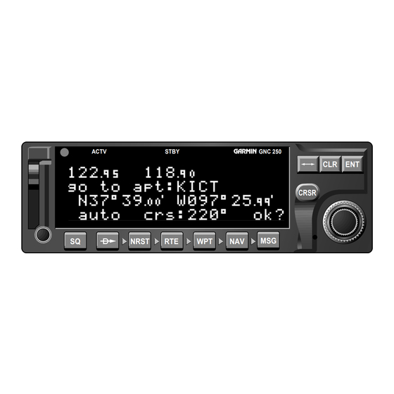
The GNC 250 uses direct point-to-point navigation to guide you from takeoff to touchdown in the VFR environment. Once a destination is selected, the unit will pro- vide speed, course and distance data based upon a direct course from your present position to your destination. -
Page 16: Navigation Diagram
REFERENCE TAKEOFF TOUR Nearest Airport Info & CDI & NAVCOM Pages Navigation Diagram CDI page with ‘trn’ and ‘trk’ displayed. CDI page with ‘brg’ and ‘trk’ displayed. NAVCOM Page In addition to the destination field and graphical CDI, the GNC 250 CDI page fea- tures four selectable fields for various navigation data so that the page may be config- ured to your own preferences (see Section 1 for more information). -
Page 17: Nearest Waypoints
Once a direct-to is activated, the CDI page will provide navigation to the destina- tion until the direct-to is cancelled or another direct-to destination is activated. To cancel a direct-to from the CDI page: 1. Press the key twice to activate the cursor in the destination field. 2. -
Page 18: Satellite Acquisition
REFERENCE TAKEOFF TOUR Nearest Airports Satellite Acquisition Shutting Down Third Nearest Airport Page To review a nearest waypoint, highlight the identi- fier and press ENT. Once the nearest airport (or any other nearest waypoint) page is displayed, the selected waypoint can be quickly reviewed or selected as a direct-to destination. To review the selected waypoint from the nearest waypoint list: 1. - Page 19 Section 1 Navigation Key The GNC 250 features six navigation pages to provide various position, course, speed, status and planning information. The pages may be viewed by pressing the NAV key and rotating the outer knob, or by pressing the NAV key repeatedly. NAVCOM page CDI page NAV Menu 2...
- Page 20 REFERENCE SECTION NAV KEY Position Page CDI Page The TO/FROM arrow will indicate whether you are ‘to’ or ‘from’ the destination waypoint. The CDI page will display ‘No actv wpt’’ in the CDI field if there is no active-to destination. The GNC 250’...
- Page 21 The following functions may be displayed in the ground speed field: • gs— Your present speed over the ground. • str— Steer direction and distance, or digital crosstrack error. An ‘L’ or ‘R’ indicates which direction to steer, while the distance value indi- cates how far you are off course.
- Page 22 REFERENCE SECTION NAV KEY Waypoint CDI & NAVCOM Pages Communication The NAVCOM page lists the frequencies for your departure (or nearest) and arrival airports in the following order: Departure Arrival • Unicom • ATIS • ATIS • Approach • Clearance Delivery •...
-
Page 23: Navcom Page
If a frequency has sector or altitude restrictions, the frequency will be followed by a ‘brg?’ indication. To view restrictions on a frequency: 1. Press twice to activate the cursor in the GPS window. 2. Rotate to highlight the ‘brg?’ next to the frequency you wish to view. 3. -
Page 24: Position Page
REFERENCE SECTION NAV KEY CDI Page Position Page Position page displaying MSA. The same position page displaying ESA. MSA and ESA are computed based on data stored in the NavData card. This information cannot be solely relied upon as an absolute measure of safe altitude in your area, particularly if the data card is out of date. - Page 25 The position page also features a reference waypoint field, located at the bottom of the page, to indicate your bearing and distance from a selected waypoint. The ref- erence waypoint field can display the following: • Range, bearing and identifier from the nearest airport, VOR, NDB, intersection, or user waypoint •...
- Page 26 REFERENCE SECTION NAV KEY NAV Menu 1 & Trip Satellite Status Page Planning Status page with EPE displayed. Status page with DOP displayed. The GNC 250’ s satellite status page provides satellite information to monitor GPS coverage and receiver performance. This is helpful when you may be experienc- ing low signal levels due to poor coverage or installation problems.
- Page 27 To change the DOP/EPE field: 1. Press and rotate to display the satellite status page. 2. If the desired field (EPE or DOP) is not displayed, press 3. Use to change between ‘epe’ and ‘dop’. Press The receiver status field, located at the top left of the page, can display the fol- lowing messages under various conditions: Search sky - The GNC 250 is searching the sky for visible satellites.
-
Page 28: Fuel Planning
REFERENCE SECTION NAV KEY Fuel Planning Satellite Data Page Viewing individual satellite information. The second and third lines of the satellite status page provide the satellite number and signal strength of each satellite in view. Additional information regarding each satellite’ s azimuth, elevation and other data is also available. To view individual satellite information: 1. -
Page 29: Trip Planning
In addition to the other four pages, the GNC 250 features two menu pages to per- form a host of planning and navigation functions. NAV Menu 1 provides access to the following functions: • Trip Planning • Density altitude/true air speed calc. •... -
Page 30: Density Altitude
REFERENCE NAV KEY SECTION VNAV & Checklists Density Altitude & True Airspeed Nav Menu 1 Density Altitude/True Airspeed Page Fuel Planning Page The density altitude/true airspeed function is also accessed from NAV Menu 1. Density altitude is the altitude at which your aircraft will perform depending on several environmental conditions, including air pressure and total air temperature (the tempera- ture including the effect of speed, read on a standard outside temperature gauge on most aircraft). -
Page 31: Fuel Planning
To perform fuel planning operations: 1. Press and rotate until NAV Menu 1 is displayed. 2. Press twice and rotate until ‘Fuel Plan?’ is highlighted. Press 3. Rotate to select either ‘wpt’ for direct navigation or the desired route number. Press 4. - Page 32 REFERENCE SECTION NAV KEY Date & Time, Winds Aloft & Trip Timer VNAV Functions NAV Menu 1 Winds Aloft Page Vertical Navigation Page The GNC 250’ s winds aloft function is used to calculate the true direction and speed of the any winds, and indicates whether you are flying with a head wind or tail wind, and the wind speed.
- Page 33 You will now notice that the vertical speed field has been calculated, based on your present speed. If you desire a more rapid climb or descent: 8. Use to enter the new desired vertical speed, or press calculated value. 9. Press to activate the vertical navigation function.
- Page 34 REFERENCE NAV KEY SECTION Scheduler, Checklists Sunrise & Sunset Approach Timer Executing a checklist. NAV Menu 2 Approach Timer To execute a checklist: 1. Press and rotate until NAV Menu 1 is displayed. 2. Press twice and rotate until ‘Chklist?’ is highlighted. Press 3.
-
Page 35: Trip Timer
When the count down timer reaches zero, you will be informed with a ‘Timer expired’ message. The timer will then begin to count up, keeping track of how long it has been since it expired. The timers run, if not altered, anytime the GNC 250 is on. The GNC 250 clock function keeps track of both UTC time (Greenwich Mean Time or Zulu Time calculated from the satellites) and local time, and allows you to designate which format is used for ETA calculations. -
Page 36: Raim Prediction
REFERENCE NAV KEY SECTION Comm Features RAIM Prediction Scheduler Enter the time and date for RAIM prediction. Confirm the selected waypoint. RAIM available for the entered time and date. The RAIM Prediction function allows you to confirm that GPS coverage is available for a specific location or waypoint any day of the year. - Page 37 The scheduler function will display reminder messages after a certain elapsed time such as Change oil, Switch fuel tanks, Overhaul, etc. For example, if you enter ‘Change Oil’ to be displayed in 30 hours, the message ‘Change Oil’ will be displayed after the GNC 250 has been on in Normal operating mode for 30 hours.
- Page 38 SECTION NAV KEY Sunrise/Sunset Calculations Sunrise/Sunset Planning Page The GNC 250’ s sunrise/sunset planning function allows you to calculate the time of sunrise or sunset at any waypoint or your present position for a specified date. To calculate sunrise and sunset times at a waypoint or at your present location: 1.
- Page 39 Section 2 Communicating with the GNC 250 The GNC 250 features a digital VHF radio that provides a seamless transition from communication to navigation, bringing the two most important functions in flying together in one panel-mount unit. The GNC 250 operates in the aviation voice band, from 118.000 to 136.975 MHz, in 25 kHz steps.
-
Page 40: Entering Waypoints
REFERENCE SECTION COMM FEATURES Entering Waypoints Overview/ Auto-Tuning To auto-tune from the nearest airport page, press ENT. To select a frequency from a list, highlight the desired frequency and press ENT. During the course of navigating with the GNC 250, there may be times when you need to quickly select a comm frequency while you are entering data in the GPS win- dow. - Page 41 To auto-tune a frequency from a list displayed in the GPS window: 1. Press twice to activate the cursor in the GPS window. 2. Rotate to highlight the desired frequency. 3. Press to make the selected frequency the standby frequency. Another useful feature integrating the GNC 250’...
- Page 42 COMM FEATURES SECTION Emergency Channel Selection The emergency channel will appear in the active field. The GNC 250’ s emergency channel select feature provides a quick method of selecting the 121.5 MHz frequency as the active frequency in the event of an in-flight emergency.
-
Page 43: Section 3: Waypoint And Database Information ( W Key)
Section 3 Waypoint and Database Information The GNC 250 uses a Jeppesen NavData® card to provide position and facility infor- mation for thousands of airports, VORs, NDBs and intersections. Each facility in the database is stored as a waypoint with its own latitude/longitude, identifier (up to five let- ters and/or numbers), and other pertinent information. - Page 44 REFERENCE WPT KEY SECTION Waypoint Categories Airport Runway Information & Menu Page Waypoint Menu Page Airport Position Page VOR Position Page The GNC 250 organizes waypoints into one of five waypoint categories for your convenience. Each waypoint category provides different types of detailed information for a selected facility: •...
-
Page 45: Vor Information
After a waypoint category is selected, information for a waypoint may be viewed by entering the identifier or name of the desired waypoint. Airports, VORs and NDBs may be entered by either the identifier, name or the location (city) of the facility. Intersections and user waypoints must be entered by the identifier. -
Page 46: Airport Information
REFERENCE SECTION WPT KEY VOR Position Page Airport Information Once a waypoint category and identifier have been selected, the GNC 250 will provide extensive information through a set of waypoint pages for the selected cate- gory. We’ll now go through the pages available for each waypoint category in the order they appear on the waypoint menu page: airports, VORs, NDBs, intersections and user waypoints. -
Page 47: Ndb Information
The GNC 250 features five airport pages: airport identification— allows entry of desired airport by identifier, facility name or city; displays region and/or country of facility. airport position— allows entry of desired airport by identifier; displays latitude, longitude and elevation; indicates usage and fuel availability; displays available approaches and airport control/radar capability. - Page 48 REFERENCE SECTION WPT KEY Airport Intersections & Position Page User Waypoints Airport Position Page 1. Identifier (selectable) 2. Elevation 3. Fuel Availability 4. Airport Position 5. Approach Information 6. Controlled Airspace/Radar Capability The airport position page displays the latitude, longitude and elevation of the selected airport, as well as usage or fuel availability, available approaches and airport control/radar capability.
- Page 49 The airport communication page displays the radio frequencies and usage for the selected airport, as well as sector and altitude restrictions. To view the communication page from any of the airport information pages: 1. Rotate with the flashing cursor removed to display the communication page. 2.
-
Page 50: Runway Lighting
REFERENCE SECTION WPT KEY Autostore ™ & Airport User Comments Runway Page Airport Runway Page for KICT. To view additional runways, rotate the inner knob in the direction of the arrow prompts. The airport runway page displays runway designations, length, surface and lighting for the selected airport, as well as ILS/localizer and/or pilot-controlled light- ing frequencies. -
Page 51: Vor Information
VOR Information The GNC 250 features three VOR waypoint pages: VOR identification— allows entry of desired VOR by identifier, facility name or city; displays region and/or country of facility. VOR position— allows entry of desired VOR by identifier; displays latitude, longitude and frequency; provides magnetic variation, weather broadcasts and DME/TACAN information. -
Page 52: Proximity Waypoints
REFERENCE SECTION WPT KEY Proximity Waypoints NDB Information & NDB Identification Page NDB Comments Page NDB Information NDB Position Page The GNC 250 also uses identification, position and comments pages for NDB information. The NDB waypoint pages are used in the same manner as VOR pages: NDB information is accessed by entering the desired facility’... -
Page 53: Intersection Information
Intersection Information Intersection Position Page The last database waypoint category available is intersections. Two intersection pages are available: intersection position and intersection comments. Intersections may be entered by identifier only (not city or name) on either intersection page. To scroll through the Intersection pages: 1. - Page 54 REFERENCE SECTION WPT KEY Duplicate & Locked User Waypoints Waypoints User Waypoint Page User Waypoint Comments Page Entering a user waypoint name. User Waypoint Information In addition to the airport, VOR, NDB and intersection waypoints contained in your NavData® card, the GNC 250 allows you to store up to 1,000 user-defined waypoints. Once a user waypoint is created, two user waypoint pages will display the following information: •...
-
Page 55: Route Overview
If the waypoint identifier entered does not exist in the database, you will be prompted to select a method to enter the new waypoint’ s position into the database. If the waypoint exists (you’re just reviewing or editing a user waypoint), skip step 4 and move on to the next set of instructions. - Page 56 REFERENCE SECTION WPT KEY Route Information Reference Waypoints Entering a user waypoint by reference waypoint. To create a user waypoint from your present posi- tion, leave the reference waypoint field blank and enter a bearing and distance from your present position.
- Page 57 The GNC 250’ s AutoStore function provides another method of creating user waypoints. AutoStore is used to instantly capture your present position as a user way- point with a touch of a button and add the new waypoint to the end of a specified route if desired.
-
Page 58: Editing Routes
REFERENCE SECTION WPT KEY Editing Routes Proximity Waypoints Proximity Waypoints Page Proximity Alarm The second page available from the GNC 250’ s WPT key is the proximity way- points page. This page allows you to define an alarm circle around a selected waypoint and is useful in defining alarm circles around towers or obstructions. -
Page 59: User Waypoint List
The third page available from the GNC 250’ s WPT key is the user waypoint list, which can be used to quickly scan, review, rename or delete user waypoints. To display the user waypoint list: 1. Press and use to display the user waypoint list. 2. -
Page 60: Waypoint Comments
REFERENCE SECTION WPT KEY CPA Diagram Waypoint Comments Entering waypoint comments. Waypoints with Comments List The last page available through the GNC 250’ s WPT key is the waypoint com- ments page, which lists all waypoints that have a user comment. User comments may be added to 250 waypoints stored in the user or NavData you to note two lines of special information concerning a particular waypoint. - Page 61 The GNC 250’ s extensive waypoint database makes it possible for several way- points to share the same identifier. To ensure that you are selecting the waypoint desired, the GNC 250 will always offer the waypoint confirmation page (which shows the waypoint’ s position) when an identifier is entered for a particular function. To accept the waypoint position: 1.
-
Page 62: Waypoint Scanning
REFERENCE WPT KEY SECTION User Comments & Locked Waypoints Parallel Track Waypoint Scanning Alarms possible for locked waypoints. To blank a waypoint field, highlight the field and press the CLR key. Because the GNC 250 relies on a NavData card for most waypoint information, there may be instances when waypoint information is not available for use. - Page 63 The GNC 250’ s NRST key provides detailed information on the nine nearest airports, VORs, NDBs, intersections and user waypoints within 200 nm of your current position. In addition, it will display the two nearest Flight Service Station (FSS) points of commu- nication and alert you to any Special Use Airspace (SUA) you may be in or near.
- Page 64 REFERENCE SECTION NRST KEY Special Use Special Use Airspace Airspace Nearest SUA Nearest SUA with controlling agency displayed. NOTE: The GNC 250 will flash the U next to the M key to inform you of SUA alerts. You do not have to repeatedly check the Nearest Waypoint page for SUA information.
- Page 65 The SUA alert page contains the following information: SUA number SUA Name or controlling agency Controlling SUA Ceiling altitude airport identifier The ‘SUA number’ field displays which SUA you are viewing (you may be alerted with up to nine SUAs). SUAs are ranked with ‘sua1’ being the highest priority, and ‘sua9’ being the lowest priority from your current position.
- Page 66 REFERENCE SECTION NRST KEY SUAs and other SUA Messages Nearest Waypoints SUA Alert Page Frequency information for SUA. The following SUA types can appear in the SUA type field: Message Airspace Type alrt - Alert caut - Caution cl B - Class B cl C - Class C...
- Page 67 SUA Settings Page All SUA alert messages except for prohibited areas may be turned on or off through the GNC 250’ s unit settings options, found under the MSG key (see page 77). Alerts for prohibited areas will always be displayed, regardless of unit settings or operating mode.
-
Page 68: Current Messages
APPENDIX A SECTION DIRECT-TO Current Messages & ROUTE NAV & ROUTE TERMINOLOGY The diagram at the right shows a basic route consisting of five waypoints and four legs. The waypoint you are travelling to is called the ‘active to’ waypoint, and the waypoint immediately behind you is called the ‘active from’... - Page 69 The GNC 250’ s direct-to function provides a quick method of setting a course to a destination waypoint. Once a direct-to destination is activated, the GNC 250 will establish a point-to-point route line along the great circle from your present position to the destination and provide steering guidance and navigation data to the waypoint until it is cancelled.
- Page 70 APPENDIX A DIRECT-TO SECTION CDI Scale Settings Manually Selecting A Course The waypoint sequencing field, located at the bot- tom left of the direct-to confirmation page, allows you to ‘hold’ on a selected route waypoint and prevent the GNC 250 from sequencing to the next route waypoint.
- Page 71 The GNC 250 lets you create up to 20 routes (numbered 0 through 19), with up to 31 waypoints each. Routes are created, copied and edited through the R key, which features two route pages selectable from the GNC 250’ s outer knob: the active route page and the route catalog page.
-
Page 72: Editing Routes
APPENDIX A SECTION ROUTES Creating & Magnetic Variation Editing Routes & Arrival Alarm Selecting the route edit function. Adding a waypoint to route 1. The route action field, located at the top right of the page, is used to select the desired route operation. - Page 73 To delete a waypoint: 1. Rotate to highlight the waypoint you wish to delete. 2. Press \ to remove the name, then press 3. Repeat steps 1 and 2 to delete additional waypoints, or press To delete an entire route: 1.
- Page 74 APPENDIX A SECTION ROUTES Display Intensity & Copying Routes Trip Timer CPA Function Calculating Closest Point of Approach. NORTH TXKO 26.7 nm KDAL Closest Point of Approach The route action field also features a copy function that permits you to copy any route to another open storage route.
-
Page 75: Navigation Units
The GNC 250’ s search and rescue function provides navigation guidance for search and rescue operations, navigating in a ladder pattern to maximize coverage and efficiency. This is done in reference to two waypoints called ‘anchor waypoints’. The first leg will be a specified distance from the line connecting the anchor waypoints. This is called the ‘offset distance’. -
Page 76: Parallel Track
APPENDIX A ROUTES SECTION Parallel Track SUA Settings Offset Navigation DEPARTURE WAYPOINT Parallel Track Enter parallel track value after route activation. During route navigation, it is sometimes desirable to navigate a specified distance away from the ‘active leg’ to help avoid certain airspaces or regions. The GNC 250’ s parallel track feature will automatically guide you along a selected offset from the active leg. -
Page 77: Map Datums
Flying and Modifying the Active Route Once a route has been created and activated, the GNC 250 will provide navigation to each route waypoint through the active route and CDI pages. From the active route page, you may also create and modify the active route. The CDI page will display detailed navigation data on your progress to each route waypoint and provide turn anticipation, waypoint arrival and next desired track information. - Page 78 APPENDIX A SECTION ROUTES Active Route Page Data Transfer Inserting Waypoints Active route page with cumulative distance and desired track displayed. Active route page with leg distance and estimated time enroute displayed. Adding KEMP waypoint to the active route. The leg field can be selected to display cumulative distance or the distance for each route leg.
- Page 79 To delete a waypoint from the active route: 1. Press twice, if necessary, to activate the cursor. 2. Use to highlight the waypoint you would like to delete from the active route. 3. Press , followed by . The next route waypoint (if available) will move up to take the position of the deleted waypoint.
- Page 80 APPENDIX B SECTION ROUTES User Data Transfer Waypoint Sequencing As you approach a route waypoint, the graphical CDI will be replaced by a flashing ‘next dtk xxxº’ prompt indicated the desired track of the next leg. If the turn angle and your present speed will require a bank angle that exceeds 25º, you’ll be notified with a ‘Steep turn ahead’...
-
Page 81: Messages And Unit Settings
Section 6 Messages and Unit Settings The GNC 250’ s MSG key provides access to system messages and allows you to cus- tomize your GPSCOM to your own preferences through a settings submenu. Whenever the GNC 250 needs to alert you to a navigation, communication or system message, the annunciator light next to the M key will flash. -
Page 82: Magnetic Variation
APPENDIX C SECTION UNIT SETTINGS CDI Settings Maintenance Magnetic Variation When the ‘auto’ CDI setting is selected, the GNC 250 will automatically change the CDI scale when you are within 30 nm of a departure or arrival airport. Entering a user magnetic variation. To change the CDI scale: 1. - Page 83 If ‘auto’ mag var is selected, all track, course and heading information will be corrected with the variation computed by the GPS. The ‘true’ setting will reference all information to true north, and the ‘user’ setting will correct information to an entered value. The GNC 250’...
- Page 84 APPENDIX D SECTION UNIT SETTINGS Battery Saver Messages & Display Intensity Abbreviations Display timeout settings. Automatic display intensity. The GNC 250’ s battery saver feature can be programmed to automatically turn off the display when using the optional remote battery pack. This will increase the remote battery life in event of power failure.
-
Page 85: Units Of Measure
The trip timer provides a running clock on NAV Menu 2 (see page 25), and can be configured to run when power is on or when your ground speed exceeds a user-defined minimum. To change the trip timer settings: 1. Press and hold , and use to display the trip timer settings page. - Page 86 APPENDIX D SECTION UNIT SETTINGS Messages & Units of Measure Abbreviations Units of Measure Settings (metric). The available units of measure are: position : • degrees, minutes and seconds (dms) [hddd° mm’ ss.s”] • degrees and minutes (dm) [hddd° mm.mmm’] altitude : •...
- Page 87 The Special Use Airspace settings page will allow you turn the controlled/restrict- ed airspace message alerts on or off. This will not affect the alerts being listed on the nearest page. It will simply turn off the warning when you are approaching or near an SUA.
-
Page 88: Map Datums
SECTION UNIT SETTINGS Map Datums Map Datum Page Map Datum Page with ‘USER’ selected. User Datum page. ® The GNC 250 NavData card contains over 100 map datums for you to use when navigating. By default, your unit calculates positions using the WGS-84 map datum. If you are using charts based on another datum, you must set the GNC 250 to use the same datum. - Page 89 The I/O setup page lets you configure the GNC 250 to output to a RS-232 mapping device or a PC (with the optional GARMIN PC Kit or other mapping software) and select the appropriate baud rate. The I/O setup page only provides access to I/O chan- nel 2 output.
-
Page 91: Saving User Data
Appendix A NavData and User Data Installation and Operation ® The NavData card supplied with your GNC 250 can be installed or removed when the GNC 250 is on or off. Insert the card with the thumb tab at the top, and the beveled corner at the bottom. - Page 92 SECTION NAVDATA CARD Saving User Data Data Transfer Page Restore Data Page To restore user data from a user data card to the GNC 250: 1. Install the user data card. 2. Rotate to highlight ‘Restore user data?’. 3. Press The GNC 250 will ask you which type of data to replace.
-
Page 93: Installation, Removal And Maintenance Of The Gnc
If the unit detects excessive oscillator drift, you will be informed with the message ‘Osc needs adjustment’. When this occurs, contact an authorized GARMIN service center for service. Failure to do so may result in severely degraded acquisition performance. - Page 94 SECTION SIMULATOR Operating Mode Page Selecting the simulator mode. Database Confirmation Page The GNC 250’ s simulator mode allows you to plan and practice flights in your home and office using an optional remote battery pack or AC adapter. The simulator is not accessible when the GNC 250 is running off the master avionics switch.
- Page 95 To enter an initial position reference by waypoint identifier: 1.Rotate to highlight the waypoint identifier field. 2. Use to spell out the identifier of the desired airport, navaid or user waypoint. 3. Press to confirm the identifier. The waypoint confirmation page will appear, display- ing the waypoint’s position.
- Page 96 Battery rqrs service - A problem has been detected in the optional remote battery pack. The battery should be ser- viced at an authorized GARMIN service center. Appendix D GNC 250 Messages and Abbreviations The GNC 250 uses the Message Page to communicate important information to you. Some mes- sages are advisory in nature, others are warnings that may require your intervention.
- Page 97 - The GNC 250 has detected a problem with the data card. The data is not usable and the card should be returned to Jeppesen or an authorized GARMIN service center. Data card write fail - The user data card failed to program. The card should be returned to an authorized GARMIN service center.
- Page 98 - The battery that sustains user memory is low and should be replaced by an authorized GARMIN service center as soon as possible. Failure to do so may result in loss of stored data, including all user waypoints and routes.
- Page 99 - The GNC 250 has detected a failure in its internal memory. If the message persists, the GNC 250 is unusable and should be taken to an authorized GARMIN service center. Rcvr needs service - The GNC 250 has detected a condition requiring service in the receiver hardware.
- Page 100 APPENDIX D SECTION MESSAGES & Messages & ABBREVIATIONS Abbreviations Searching the sky - The GNC 250 is in the search-the-sky mode. Allow the unit to complete data collection before turning it off. Start altitude chng - The altitude change entered on the VNAV Planning page is about to begin.
- Page 101 This section of Appendix D provides a complete list of GNC 250 abbreviations and their meanings. ALT- Altitude DIS- APP- Approach DME - APR- Approach DOP- APT- Airport Waypoint DTK- ARV- Arrival ELEV- ATF- Aerodrome Traffic Frequency ENDUR- Endurance ATS- Automatic Terminal Information EPE- Service (ATIS)
- Page 102 APPENDIX D SECTION MESSAGES & Messages & ABBREVIATIONS Abbreviations JET A- Jet Fuel - Type A NDB- JET B- Jet Fuel - Type B Kilometers Per Hour Kilometers Knots OBS- Pounds LCL- Local OTH- LEN- Length ºC- LFOB- Leftover Fuel On Board ºF- LFLOW- Left Fuel Flow LOC-...
-
Page 103: Specifications
RTE- Route USR- UTC- Receive Only SAR- Search And Rescue SEC- Seconds VNAV- SEQ- Sequence SGL- Signal VOR- WPT- SLCT- Select SRFC- Surface STR- Steer To XFR- TACAN- TACtical Air Navigational Aid TAS- True Airspeed TAT - Total Air Temperature TEMP- Temperature TMA-... - Page 104 APPENDIX F SECTION SPECIFICATIONS Map Datums ** Subject to accuracy degradation to 100m 2DRMS under the US DOD-imposed Selective Availability Program. Whenever the GNC 250 is connected to the optional remote battery pack and power from the master switch is lost, the unit will revert to bat- tery power.
- Page 105 Appendix F Map Datums ADINDAN Ethiopia, Mali, Senegal, DOS 1968 Sudan AFGOOYE Somalia EASTER ISLAND 1967 AIN EL ABD 1970 Bahrain Island, Saudi Arabia EUROPEAN 1950 ANNA 1 ASTRO 1965 Cocos Islands ARC 1950 Botswana, Lesotho, Malawi, Swaziland, Zaire, Zambia, Zimbabwe ARC 1960 Kenya, Tanzania EUROPEAN 1979...
- Page 106 APPENDIX F SECTION MAP DATUMS Map Datums LUZON PHILIPPINES Philippines OMAN (excluding Mindanao Isl.) ORD SRV GRT BRITAIN MAHE 1971 Mahe Island MARCO ASTRO Salvage Islands PICO DE LAS NIEVES MASSAWA Eritrea (Ethiopia) PITCAIRN ASTRO 1967 MERCHICH Morocco PORTUGUESE 1973 MIDWAY ASTRO 1961 Midway Island POTSDAM...
- Page 107 Appendix G Index Abbreviations 91-93 CDI page Accessory list CDI sensitivity setting Channel 2 I/O Activating a direct-to 5, 58-60 Checking GPS coverage Activating a route Checklists Activating a route in reverse Clear key Active frequency 3, 29 Clock function Active to &...
- Page 108 APPENDIX G SECTION INDEX Index Editing routes 62-63, 67-69 Magnetic variation Editing user waypoints 44,46,49 Maintenance of the GNC 250 ENT key viii Map datums Entering waypoints 35,46 Measurement units Messages Emergency channel select MSG key Foreword NAVCOM page Flying the active route 67-70 NavData cards Fuel planning...
- Page 109 RAIM prediction Table of contents RAIM protection Time Radar information Transfer key Receiver status 16-17 Trip planning Removal of the GNC 250 Trip timer Renaming user waypoints 47,49 Trip timer settings Restoring user data 81-82 True air speed Reversing a route Turn anticipation Route catalog page Route comments...
- Page 110 APPENDIX G SECTION INDEX Index Waypoint scanning Waypoint sequencing 69-70 Waypoints with comments Winds aloft...
- Page 112 ® © 1995 GARMIN International 9875 Widmer, Lenexa, KS 66215, USA GARMIN/Europe LTD Robert House, Station Approach Romsey, Hampshire SO51 8DU UK Part No. 190-00067-50 Rev. A...
Need help?
Do you have a question about the nüvi 250 and is the answer not in the manual?
Questions and answers