Table of Contents
Advertisement
Quick Links
Advertisement
Table of Contents

Subscribe to Our Youtube Channel
Related Manuals for SatLab SLT12


Summary of Contents for SatLab SLT12
- Page 1 SLT12 User Manual SLT12 Android Total Station User Manual...
- Page 2 SLT12 User Manual Manual Revision Revision Date Revision Level Description SLT12 Series User Manual Aug. 2023 Version 1.0...
- Page 3 SLT12 User Manual SLT12 Android Total Station User Manual...
-
Page 4: Preface
Welcome to the Satlab SLT12 Android Total Station. These instructions describe how to use this product. Experience Requirements To help you use the Satlab series of products better, Satlab suggests that you read the instructions carefully. If you are unfamiliar with the product, please refer tohttp://www.satlab.com.se/... - Page 5 SLT12 User Manual If you have any technical issues, please call the Satlab technology department for help, and we will answer any questions you have. Relevant information You can obtain this introduction by: Purchasing Satlab products: this manual is found in the instrument container and will help you to operate the instrument.
-
Page 6: Table Of Contents
SLT12 User Manual Contents Preface ................................. I Instruction ..............................I Experience Requirements ...........................I Contents ..............................III Chapter 1 ..............................1 Overview ..............................1 1.1 Foreword ............................2 1.2 Cautions ............................3 1.3 Security Guide ........................... 4 Chapter 2 ..............................6 Product introduction ..........................6 2.1 Component Names .......................... - Page 7 SLT12 User Manual 4.3.3 Example of setting up the station ....................26 4.3.4 Data Acquisition ........................27 4.3.5 Data Export ..........................28 Chapter 5 ..............................31 Basic Measurements ..........................31 5.1 Measure (Coordinate Measurement) ....................32 5.2 Point S.O (Coordinate Stakeout) ......................35 Chapter 6 ..............................37 Set up Station ............................37...
- Page 8 SLT12 User Manual 8.1.2 Layer Display ..........................68 8.1.3 Delete Base Map ........................68 8.1.4 Open the Last Base Map ......................69 8.1.5 CAD Stakeout Tool ........................70 8.1.6 Line stakeout ..........................70 8.1.7 CAD Point Stakeout ........................72 8.2 Point S.O ............................73 8.3 Image ..............................
- Page 9 SLT12 User Manual 10.1 Project ............................110 10.2 Point Library ..........................111 10.2.1 All Points ..........................113 10.2.2 Measurement Points .......................115 10.2.3 Stakeout Point ........................116 10.2.4 Control Points ........................119 10.3 Ground Code ..........................119 Chapter 11 ...............................124 Road ..............................124 11.1 Road Design ..........................
- Page 10 SLT12 User Manual 14.1.5 Grid Factor ........................... 169 14.1.6 Atmospheric Refraction Coefficient ..................170 14.2 Other ............................170 14.2.1 Distance Measurement Beep ....................171 14.2.2 Key Tone ..........................171 14.2.3 Screen Display ........................171 14.2.4 Laser Pointing ........................172 14.2.5 Signal Strength ........................172 14.2.6 Baud Rate ..........................
- Page 11 SLT12 User Manual 15.6 FTP .............................184 15.7 Register TS ..........................185 Chapter 16 ...............................186 Top Shortcut Function .........................186 16.1 Dist Mode(distance measurement) ....................187 16.2 Tilt Compensation ........................187 16.3 Reflector Type Switching ......................188 16.4 Laser Pointing ..........................188 16.5 Point Data ............................188 16.6 More ............................
- Page 12 SLT12 User Manual 17.7.1 Check ........................... 197 17.7.2 Adjust ...........................198 17.8 Instrumentation Plus Constant (K) ....................199 17.8.1 Check ........................... 199 17.8.2 Adjust ...........................199 17.9 The parallelism between the Axis of Visual Alignment and the Axis of Emitting Electric Light ..200 17.9.1 Check ...........................
-
Page 13: Chapter 1
SLT12 User Manual Chapter 1 Overview This chapter contains: - Foreword - Cautions - Security Guide... -
Page 14: Foreword
SLT12 User Manual 1.1 Foreword This SLT12 Total Stations is based on the Android hardware platform, Supports angle measurement, distance measurement, key light, serial port, Bluetooth, Wi-Fi, USB, automatic tilt compensation, high centering, key tone, support installation of GNSS equipment at the same point, support total station command communication protocol, with powerful industry application software, including project management, station setting, basic measurement, program measurement, road stakeout, bridge, tunnel, map, configuration. -
Page 15: Cautions
SLT12 User Manual The instrument has the image-assisted stakeout function, which can display the stakeout point mark on the software interface, which is convenient for aiming at the stakeout point. 1.2 Cautions 1. Avoid looking directly into the sun with the eyepiece when measuring. Recommended to use a solar filter to reduce the impact. -
Page 16: Security Guide
SLT12 User Manual Note: This instrument is subject to strict inspection and calibration at the factory, and the quality meets the standard requirements. But the instrument after long-distance transport or environmental changes, the instrument's optical and mechanical structure parameters of trace changes are inevitable. - Page 17 SLT12 User Manual Prevention: To avoid injury, each user must carry safety prevention measures and operate the instrument within the safety scope according to standard IEC60825-1: 2001). The following is the explanation of the main part of the standard: Class 3R level laser products are used outdoors and in construction (surveying with No-Prism).
-
Page 18: Chapter 2
SLT12 User Manual Chapter 2 2 Product introduction This chapter contains: - Component Names - Keyboard Functions and Display Information... -
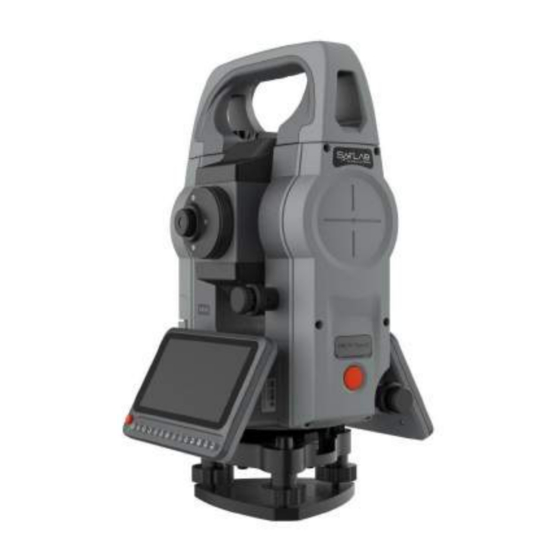
Page 19: Component Names
SLT12 User Manual 2.1 Component Names 1 Coarse sight Eyepiece 5 2 Focusing knob 3 Inching hand-wheel Vertical braking knob Battery case 6 4 Touch screen Leveling knob 7 Figure 2-1 11 Objective lens 12 Camera Type-C slot SD card slot 9... -
Page 20: Keys Functions And Display Information
SLT12 User Manual 2.2 Keys Functions and Display Information Figure 2-3 Table 2.1 Key functions Name Function Shortcut Measurement Key Trigger a measurement when clicked. Power Key Power ON/ Power OFF. 0 ~ 9 Number Key Enter the number 0~9. - Page 21 SLT12 User Manual Horizontal angle (left angle) Horizontal distance. dHD is to stake out differences in horizontal distance Elevation difference. dVD is to stake out differences in elevation Slope distance. dSD is to stake out differences between slope distances North coordinates, dN is to stake out differences between north-coordinates...
-
Page 22: Chapter 3
SLT12 User Manual Chapter 3 3 Preparation before Measurement This chapter contains: - Unpacking and Storage - Placement of Instruments - Battery Loading and Unloading, Information and Charging - Reflective Prisms - Loading and Unloading of Bases - Telescope Eyepiece Adjustment and Target Illumination... -
Page 23: Unpacking And Storage
SLT12 User Manual 3.1 Unpacking and Storage - Unpacking Lay the box gently down with the top side facing up. Open the lock and take out the instrument. - Storage Cover the telescope with its cover. Make sure that the vertical clamping screw and the level bubble are facing upwards. - Page 24 SLT12 User Manual Figure 3- 1 4) Using the plate level to level the instrument precisely ① Loosen the horizontal locking screw and turn the instrument around until the plate level is perpendicular to a line defined by screws A and B. Adjust screws A and B to position the bubble in the center of the level.
- Page 25 SLT12 User Manual Figure 3- 3 ③ Turn around the instrument 90° again. Repeat the above steps until the bubble remains in the center of the plate level even when the instrument is rotated to any position. Using a centering device to center...
-
Page 26: Loading And Unloading Of The Battery
SLT12 User Manual 4) Using the tubular level to level the instrument precisely ① Loosen the horizontal brake screw and turn the instrument so that the tube level is parallel to the line of foot spirals A and B. By rotating foot spirals A and B, center the bubble of the tube level. -
Page 27: Reflecting Prism
SLT12 User Manual ▲ To install the battery, press the top button of the battery compartment to snap it into the instrument and secure it into place. Notes for charging: ▲ Though the charger is designed with an overcharge protection circuit, we recommend unplugging the charger after charging has finished. -
Page 28: Entering Letters And Numbers
SLT12 User Manual keep a distance of about 200 mm away from the sighting device. ③ Use the telescopic focusing screw to make the target image clear. When the eye moves up and down or left and right at the end of the eyepiece to find parallax, it means that the focus or eyepiece diopter is not well adjusted. - Page 29 SLT12 User Manual Figure 3- 5 Simply type SUN1A on the soft keyboard that pops up. Figure 3- 6 *Enter numbers [Example 2] Select the station setting mode, click on the "+" sign in the station interface, enter the coordinates of...
- Page 30 SLT12 User Manual Figure 3- 7 Method 1 The key sequence at the bottom of the screen: [-]→[1]→[2]→[3]→[.]→[4]→[5]→[6] The results are shown in the following figure. Figure 3- 8 Method 2 In the pop-up soft keyboard key sequence: [-]→[1]→[2]→[3]→[.] →[4]→[5]→[6]...
-
Page 31: Notice For Using U Disk
SLT12 User Manual Figure 3- 9 3.8 Notice for using U disk This machine supports a maximum of USB2.0/2.1/3.0/3.1 128G USB flash drive reading and writing, when running the program, don’t insert or pull out the U disk. If you do so when the instrument is in use, the action may cause an error! 3.9 Instrument Registration... - Page 32 SLT12 User Manual Figure 3- 11 Figure 3- 12 2) Enter the Total Station information interface, click [REGISTER], and enter the correct registration code in the pop-up input box (please contact your dealer to obtain it). Figure 3- 13...
-
Page 33: Notes On Instrument Data Storage Size Prompt Messages
SLT12 User Manual 3) After entering the correct registration code, press the [OK], indicate that the registration is successful and the displayed registration expiration time is shown correctly. Figure 3- 14 3.10 Notes on Instrument Data Storage Size Prompt Messages When the amount of free memory in the instrument is less than 100k, the prompt "Disk is below 100K, please... -
Page 34: Chapter 4
SLT12 User Manual Chapter 4 4 Software Introduction and Operation This chapter contains: - Software Introduction - Software Installation - Quick Start... -
Page 35: Software Introduction
The software also supports road, bridge, and tunnel-related design and stakeout operations. 4.2 Software Installation ST-Surv should be run on Android 9 or above operating system. It can run on Android devices such as Satlab professional Android total station, professional survey handbook, and ordinary cell phones. It can be installed by copying the ST-Surv apk(Android Package) to the Android terminal device or using a third-party software for installation via the computer. - Page 36 SLT12 User Manual Users can choose whether to turn on the tilt compensation or not according to the actual operation scenario. To ensure the accuracy of the angle measurement, it is recommended not to turn off the tilt compensation, whose display can also be used to better level the instrument.
- Page 37 SLT12 User Manual Figure 4- 3 Figure 4- 4 Figure 4- 5...
-
Page 38: Create Project
SLT12 User Manual 4.3.2 Create Project To create a new project, click [Project], click the blue hover [+] button on the interface (button can be dragged), enter the project name (required), Creator, Remarks, and other information, select Ground Code template, confirm that there are no errors and click [OK] to complete the new project. -
Page 39: Data Acquisition
SLT12 User Manual 2. Click [Station] - [STN Setup], and choose "By Known PT" as the orientation method. Set the coordinates of known point A for the station, set the coordinates of known point B for the backsight point, and enter the instrument height and target height correctly. -
Page 40: Data Export
SLT12 User Manual Figure 4- 10 2. Aim at the target point, enter the point Name, Code, Target Height, and click [Meas.] - [Store] or directly click [Meas.&Store] to measure. 4.3.5 Data Export 1. Click the top bar icon, and go to [Point Data] - [Meas. Point], you can view the station point, backsight point, prism point, and other kinds of total station points. - Page 41 SLT12 User Manual Figure 4- 12 2. Click the hover button-[Export] to enter the data export interface. Figure 4- 13 3. Select the export format, enter the file name, and click "OK" to export the data to the internal storage of the...
- Page 42 SLT12 User Manual Figure 4- 14 Figure 4- 15...
-
Page 43: Chapter 5
SLT12 User Manual Chapter 5 5 Basic Measurements This chapter contains: - Measure - Point S.O... -
Page 44: Measure (Coordinate Measurement)
SLT12 User Manual 5.1 Measure (Coordinate Measurement) Click [Measurement] - [Measure] or [Collection] - [Measure] to enter the Coordinate Measurement interface. Figure 5- 1 "Name": Measured point name, automatically accumulated by number by default. "Code": Description of the measured point, which can be entered manually or selected by clicking the button behind the input box. - Page 45 SLT12 User Manual When measuring, you can also choose to record the description of the point at the same time. The operation is as follows. 1. Click the […] icon in the top bar - [Meas. Auxiliary] and turn on the switch of Note.
- Page 46 SLT12 User Manual Figure 5- 5 The following buttons are common to all collection/stakeout interfaces and will not be repeated after the explanation here. [Meas.&Store]: Start coordinate measurement and store the data in the measurement point library. [Meas.]: Start coordinate measurement.
-
Page 47: Point S.o (Coordinate Stakeout)
SLT12 User Manual Figure 5- 6 5.2 Point S.O (Coordinate Stakeout) Access through [Measurement] - [Point S.0] or [Stake out] - [Point S.0]. Figure 5- 7 [Last] / [Next]: Switch to select the stakeout point in the stakeout point library. - Page 48 SLT12 User Manual Figure 5- 8 "Point Name Search": Perform a precise search based on the entered point name. "List Point Selection": Jump to the point library and you can select points from each point library. [Save to Stake Pts Lib]: If checked, the currently set stakeout points will be saved to the stakeout point library.
-
Page 49: Chapter 6
SLT12 User Manual Chapter 6 6 Set up Station This chapter contains: - Station Backsight - Backsight check - Resection - Elevation Transfer - Point to Line Station Set-up... -
Page 50: Stn Setup (Orientation With Backsight)
SLT12 User Manual 6.1 STN Setup (Orientation with Backsight) Click [Station] - [STN Setup] or "each measurement interface" - " STN Setup" button to enter the station setup interface. The station setup with backsight currently supports four orientations: By Known PT, By Azimuth, Without cp, and by free orientation. -
Page 51: By Known Pt
SLT12 User Manual Figure 6- 3 Figure 6- 4 6.1.1 By known PT Coordinate orientation applies to the case where the coordinates of the survey site and the coordinates of the backsight point are known. The operation steps are as follows. -
Page 52: Azimuthal Orientation
SLT12 User Manual Figure 6- 5 1. Set the coordinates of the survey site, the coordinates of the backsight point, the instrument height, and the target height. Coordinates can be set by "list point selection" or "input". 2. Click "OK" to align the Backsight point. At this time, the measurement difference check box will pop up. If the user judges that the difference value is within the acceptable range, click "OK", that is to complete the station... -
Page 53: Without Cp
SLT12 User Manual 1. After the user sets up the total station at the survey site, enter the [station hindsight] and select azimuth orientation for the orientation mode. Figure 6- 7 2. Set the coordinates of the survey site, the azimuth of the Backsight point, the instrument height, and the target height. -
Page 54: Free Station
SLT12 User Manual 2. Set the coordinates of the survey site, the point name of the backsight point, the instrument height, and the target height. Coordinates can be set by "list point selection" or "input". 3. Click on "OK" to complete the station hindsight. -
Page 55: Resection
SLT12 User Manual Figure 6- 10 [Meas.]: Click measurement when aiming at the Backsight point, and get the coordinate difference between the measurement coordinates and the Backsight point, and the distance difference to the measuring station. [Reset]: Reset the horizontal angle to the Backsight point azimuth. - Page 56 SLT12 User Manual Figure 6- 12 2. Click "Select target PT", the target point is known. Users can set it by "manual input", "list point selection" or "search point library". [OK]: After setting the coordinates of the target point, click "OK" to finish the setting and return to the measurement interface.
- Page 57 SLT12 User Manual Figure 6- 14 [Angle meas.]: Click on the angle meas. when aiming at the target point, and get the angle data from the measurement station to the target point. [Dist.meas.]: Click dist.meas. when aiming at the target point to get the slant distance from the measuring station to the target point.
-
Page 58: Elevation Transfer
SLT12 User Manual Figure 6- 15 [Add PT]: You can continue to add known points for measurement and repeat steps 2~3. [Compute]: Based on the current existing measurement points and the set instrument height, calculate the coordinates of the measurement site. - Page 59 SLT12 User Manual you can use the elevation transfer function to calculate and obtain the coordinates of the survey site after the station is set up in the station's hindsight. You can enter the elevation transfer interface through [STN Setup] - [Elevation Transfer].
- Page 60 SLT12 User Manual Figure 6- 19 [Meas.]: Click measure when aiming at the target point to get the slant distance from the measuring station to the target point. [Store]: After you have measured the target point, click " store " to return to the point list and store the distance measurement point in the measurement point library.
-
Page 61: Point To Line
SLT12 User Manual [Compute]: Based on the current existing measurement points and the set instrument height, calculate the elevation of the measurement site. Figure 6- 21 [Back]: Return to the elevation transfer point list interface, you can continue to add points to calculate. - Page 62 SLT12 User Manual Figure 6- 22 2. Enter the measurement interface of straight line - end point B. Enter the target height according to the instruction, click "Meas." for the end point of the reference line, and then click "Next".
- Page 63 SLT12 User Manual Figure 6- 24...
-
Page 64: Chapter 7
SLT12 User Manual Chapter 7 7 Collection Program This chapter contains: - Measure - Dist. Offset - Plane Offset - Column Offset - MLM - REM - Line & Extension Point - Line & Angle... -
Page 65: Measure (Coordinate Measurement)
SLT12 User Manual 7.1 Measure (Coordinate Measurement) See Chapter 5 Basic Measurement - Coordinate Measurement. 7.2 Dist. Offset If the point to be measured (P) is known to deviate from the Offset point (T0) in the observation direction of the front and rear, left and right Offset, then the coordinates of the T0 point can be measured by the Distance Offset function. -
Page 66: Plane Offset
SLT12 User Manual 3. Click "Next" to display the distance and coordinates of point T0. Figure 7- 3 [Store]: store the Offset points obtained by calculation to the point library. [Next point]: You can recalculate the next point from step 1. -
Page 67: Column Offset
SLT12 User Manual being measured. Figure 7- 5 3. Aim at Measured point P0, Then the instrument calculates and displays the coordinates of the point of intersection of the alignment axis and the plane - the coordinates of point P0. - Page 68 SLT12 User Manual 1. Aim at the first point P1 on the edge of the cylinder, click "Next", and get the horizontal angle data while going to the next step. Figure 7- 7 2. Aim at the second point P2 on the edge of the cylinder and click "Next" to get the horizontal angle data while going to the next step.
-
Page 69: Mlm
SLT12 User Manual Figure 7- 9 4. Click "Next" to derive the coordinates of the center of the cylinder, you can choose [Store], [next point]. Figure 7- 10 7.5 MLM MLM is used to calculate the SD(slope distance), HD(horizontal distance), and VD(vertical distance) of two target points, after measuring a series of points, you can connect the target points by "ray"... - Page 70 SLT12 User Manual Figure 7- 11 Figure 7- 12 You can enter the interface of MLM through [Collection] - [MLM]. The operation steps are as follows. 1. After the user sets up the station, click [MLM] to enter the measurement interface. After measuring the first...
- Page 71 SLT12 User Manual Figure 7- 13 2. Enter the [MLM] data page to display the measurement point data information. [Meas.]: Enter the measurement interface, you can add points for measurement operation. [Clear]: Clear all the point information on the current data page.
-
Page 72: Rem
SLT12 User Manual Figure 7- 15 7.6 REM Remote Elevation Measurement is used to directly measure the elevation difference from the overhang point to the base point where the prism cannot be placed above the base point, divided into ground overhang height and reference point overhang height. -
Page 73: Reference Point Rem
SLT12 User Manual 2. Aim at the target point T, Get the value of REM in real-time. Figure 7- 17 [Prev.]: Return to the previous step, you can view the previous measurement information. [Finish]: Restart the REM. 7.6.2 Reference Point REM The ground overhang height is used to calculate the distance from the target point to the reference point without filling in the target height. -
Page 74: Line & Extension Point
SLT12 User Manual Figure 7- 19 3. Aim at the target point T, and the software calculates the value of REM in real-time. Figure 7- 20 [Prev.]: Return to the previous step, you can view the previous measurement information. [Finish]: Restart the REM 7.7 Line &... - Page 75 SLT12 User Manual 1. Users enter [Line&Extend Point], enter the extension distance, and click [OK]. Figure 7- 21 2. Enter the target height, aim at the starting point, click [Meas.], get the angle and distance measurement data, and click [Next].
-
Page 76: Line & Angle
SLT12 User Manual Figure 7- 23 [Store]: Store the target points obtained by calculation in the point library. [Next line]: You can recalculate the next point from step 1. 7.8 Line & Angle When the point to be measured is on the line of two measurable points, but the distance relationship between the point to be measured and the measurable point is not known, you can use the [Line&Angle point] function for... - Page 77 SLT12 User Manual 2. Enter the target height, aim at the end point of the straight line, click [Meas.], get the angle and distance measurement data, and click [Next]. Figure 7- 25 3. Aim at the target point, and the software displays the calculated coordinates of the target point.
-
Page 78: Chapter 8
SLT12 User Manual Chapter 8 8 Stakeout program This chapter contains: - CAD - Point S.O - Image - Angle & Dist. - Directional Line - Straight Line - RefLine - RefArc... -
Page 79: Cad
SLT12 User Manual 8.1 CAD CAD stakeout allows you to select features from imported dxf and dwg format files and perform point stakeout and line stakeout on the selected features. 8.1.1 CAD Data Import Click [Stake out] → [CAD] to enter the CAD stakeout interface, expand the right toolbar, click the [Data] button to enter the CAD data interface, click the [Importing files] button below to select and import CAD data, and import data support *. -
Page 80: Layer Display
SLT12 User Manual 8.1.2 Layer Display Click the [DATA] button in the CAD stakeout interface to enter the data interface, and control the display of the corresponding layer by the eye in front of the layer, the layer is displayed when the eye is open, and the layer is not displayed when the eye is closed. -
Page 81: Open The Last Base Map
SLT12 User Manual Figure 8- 5 8.1.4 Open the Last Base Map After you have opened the CAD Base Map file, the next time you enter the CAD stakeout module, a pop-up window will prompt you whether to open the last file, if you click Open, the last file will be loaded; otherwise, it will not be loaded. -
Page 82: Cad Stakeout Tool
SLT12 User Manual 8.1.5 CAD Stakeout Tool When you enter the CAD Stakeout interface, click on the Settings button in the right toolbar to expand the CAD module's related tools. Font size: You can modify the dot name size of the acquisition points in the CAD stakeout interface. - Page 83 SLT12 User Manual Figure 8- 7 Figure 8- 7 The default checkbox of "stakeout line node" in the setting interface of stakeout parameters means that the stakeout target can also be switched to the node of the stakeout line when it is switched by the increment of front and rear offset;...
-
Page 84: Cad Point Stakeout
SLT12 User Manual Figure 8- 8 Figure 8- 8 8.1.7 CAD Point Stakeout For CAD interface graphics, you can use the [Select Point] button to select special marker points and click OK after successful selection to stake out the selected points. -
Page 85: Point S.o
SLT12 User Manual 3. Pick up the stakeout point successfully, and jump to the stakeout interface to start the stakeout. 4. The total station aim at the prism, and then clicks the meas&store/meas.- Store to calculate the stakeout information, according to which the prism can be moved to the position to be stakeout. - Page 86 SLT12 User Manual the target points to be stakeout by manual input or list selection of points. Figure 8- 10 2. After selecting the stakeout point, click OK, return to the stakeout interface, and click the previous point and next point buttons to switch the point data in the stakeout point library for stakeout.
-
Page 87: Image
SLT12 User Manual Figure 8- 12 Figure 8- 13 8.3 Image The total station is equipped with an image function, which will display the camera view on the screen. When the stakeout point is set, it will mark the location of the stakeout point on the interface and perform the stakeout prompt to the left/right and up/down. - Page 88 SLT12 User Manual Figure 8- 14 2. After selecting the stakeout point, the graphical interface shows the hints to the left/right and up/down; the side slider also shows the stakeout distance hints. Figure 8- 15 3. According to the instructions to turn the eyepiece, when the target point is in the visual range, you can see a...
-
Page 89: Angle&Dist
SLT12 User Manual Figure 8- 16 [Meas&store]: While measuring prism points, save prism point information to the total station point library. [Meas.]: Measure the coordinates of the prism point. [Store]: When the coordinates of the prism points have been measured, click Store to save the prism point information to the total station point database. - Page 90 SLT12 User Manual Figure 8- 17 Click OK to jump to the angle and distance stakeout interface, and click angle and distance parameters to modify and adjust the stakeout point setting parameters. Click Save/Measure/ Store to display the stakeout information, and move the prism according to the stakeout information to reach the target location of the stakeout point.
-
Page 91: Directional Line
SLT12 User Manual Figure 8- 19 8.5 Directional Line Directional line Stakeout can be set by inputting azimuth, level distance, and elevation difference from reference point to reference point to set the Stakeout point for Stakeout. Click [Directional Line setting] to enter the directional line parameter setting interface, after selecting the reference point (the reference point can be selected by manual input, list selection, measurement selection, etc.),... -
Page 92: Straight Line
SLT12 User Manual Figure 8- 21 Figure 8- 22 8.6 Straight Line Straight Line Placing allows you to place custom lines by setting the placing parameters. Click [Straight Line] to enter the line definition interface, and set the starting point and end point to create a... - Page 93 SLT12 User Manual Figure 8- 23 After setting the line, click OK to enter the setting interface of stakeout parameters, you can set the stakeout parameters such as left/right offset, front/back offset, front/back offset increment, top/bottom offset, etc. Click OK to enter the line stakeout interface.
-
Page 94: Refline
SLT12 User Manual Figure 8- 25 Figure 8- 26 8.7 RefLine Reference line Stakeout can define the reference line by setting parameters such as start/end point and baseline offset, rotation, etc., and perform Stakeout operations on the reference line after configuring the Stakeout parameters. -
Page 95: Reference Line Stakeout
SLT12 User Manual Figure 8- 27 Figure 8- 28 8.7.2 Reference Line Stakeout After defining the reference line and its baseline offset, click OK to enter the setting interface of stakeout parameters, set the stakeout parameters such as left/right offset, front/back offset, front/back offset increment,... - Page 96 SLT12 User Manual Figure 8- 29 If the front and back offset increment is set, the stakeout screen shows the switch button of the previous and next point, and click it to switch the target point of the stakeout according to the offset increment.
-
Page 97: Refarc
SLT12 User Manual Figure 8- 31 8.8 RefArc The reference arc stakeout can be defined in different ways, and the stakeout operation can be performed on the reference arc after configuring the stakeout parameters. 8.8.1 Reference Arc Definition Click [RefArc] to enter the reference arc definition interface, there are three reference arc definition methods to choose from: "center + start PT", "Start PT + End PT + radius", "Start PT+ End PT + PT on the arc ", after... -
Page 98: Reference Arc Stakeout
SLT12 User Manual Note: 1. When using the "Center + start PT" and "Start + End + Point on Arc" methods to calculate the radius of the reference arc, only the 2D projection coordinates are considered, i.e. the radius is calculated in the 2D plane, independent of the Z coordinate of the reference point. - Page 99 SLT12 User Manual Figure 8- 33 Figure 8- 34 Figure 8- 35...
- Page 100 SLT12 User Manual Stakeout arc Select the arc stakeout item, set the closing difference, starting arc distance, diameter distance, arc increment, and other parameters, and then click OK to jump to the reference arc stakeout interface, click Save/Measure- Store to calculate the stakeout information, and expand the right graphical interface to display the current position, prism points, and the position relationship between the stakeout points.
- Page 101 SLT12 User Manual Figure 8- 37 Figure 8- 38 Stakeout chord Select the chord item, set the closing difference, starting chord length, diameter distance, chord increment, and other parameters, and then click OK to jump to the reference arc stakeout interface, click Save/Measure/ Store to calculate the stakeout information, and expand the graphic interface on the right to display the current position, prism points and the position relationship between the stakeout points.
- Page 102 SLT12 User Manual Figure 8- 39 Figure 8- 40 Figure 8- 41...
- Page 103 SLT12 User Manual Stakeout sample rounding angle Select the stakeout center angle item, set the closing difference, starting center angle, diameter distance, angle increment, and other parameters, and then click OK to jump to the reference arc stakeout interface, click Save/Measurement- Store to calculate the stakeout information, and expand the graphic interface on the right to display the current position, prism points, and the position relationship between the stakeout points.
- Page 104 SLT12 User Manual Figure 8- 44...
-
Page 105: Chapter 9
SLT12 User Manual Chapter 9 9 COGO This chapter contains: - Without CP Correction - Free Station Correction - Calc.XYZ - Inverse - Area & Girth - Angle Conversion - Dist. Conversion - Average - Transition Curve - Equidistant point... -
Page 106: Without Cp Correction
SLT12 User Manual 9.1 Without CP correction The unknown point orientation correction function is used to post-process the data recorded from the unknown point orientation set-up measurements, i.e., to perform hindsight correction. The module can be accessed through [COGO] - [Without CP correction]. The operation steps are as follows. -
Page 107: Free Station Calibration
SLT12 User Manual point orientation correction. The corresponding measurement coordinate points in the point data are corrected according to the selected hind viewpoint coordinates. Figure 9- 3 9.2 Free Station Calibration The orientation-free correction function is used to post-process data recorded from orientation-free set-up measurements, i.e., to perform the hind-sight correction. - Page 108 SLT12 User Manual Figure 9- 4 Figure 9- 5 3. Click on the list selection button after the measurement point to select the measurement point for which you know the correct coordinates. Figure 9- 6...
-
Page 109: Common Point Method
SLT12 User Manual 4. Enter or list select the known coordinates corresponding to the measurement point at the known coordinates. Click [Correct]. Figure 9- 7 5. If the correction is successful, the corresponding measurement coordinates in the point data are modified to the corrected coordinates. - Page 110 SLT12 User Manual and Known coord 2, respectively. Figure 9- 9 3. Select the orientation of the common point, if the common point is on the left side of the line from station 1 to station 2, that is, select "STA 1->2 left", and vice versa, select "STA 1->2 right".
- Page 111 SLT12 User Manual Figure 9- 11 Figure 9- 12 Figure 9- 13...
-
Page 112: Calculator
SLT12 User Manual 9.3 Calculator Tool for performing simple mathematical calculations. 9.4 Calc. XYZ The coordinate orthogonal calculation function can derive the specific coordinate information of the endpoint by setting the spatial relationship between the start point and the endpoint relative to the start point. -
Page 113: Inverse
SLT12 User Manual Figure 9- 15 Figure 9- 16 9.5 Inverse The coordinate back-calculation function can derive the spatial information of the endpoint concerning the start point from the coordinate information of the start point and the endpoint. The start point and end point can be input and selected by manual input, list selection, measurement selection, etc. -
Page 114: Area&Girth
SLT12 User Manual Figure 9- 17 Figure 9- 18 9.6 Area&Girth Click to enter the area perimeter, you can select multiple point data to form the group of polygon vertices that need to calculate the area by manual input, list selection of points, measurement selection of points, etc. - Page 115 SLT12 User Manual Figure 9- 19 Figure 9- 20 Figure 9- 21 Click Calculate after you finish the selection, you can jump to the resulting interface to view the calculation results, including graphical results and area length data results.
-
Page 116: Angle Conversion
SLT12 User Manual Figure 9- 22 9.7 Angle Conversion Supports the conversion of radians, degrees, gauges, minutes, mils, and degrees-minutes-seconds units to each other. After entering the value in any item, click [Compute] to calculate the value in other formats. -
Page 117: Average
SLT12 User Manual Figure 9- 24 9.9 Average Users can click [COGO] - [Average] to enter this interface and calculate the average of several points coordinates by this function. Click the Add button to add the points to be calculated to the list below, then the average value of the coordinates of the selected points will be displayed at the top in real-time. -
Page 118: Transition Curve
SLT12 User Manual Figure 9- 26 Figure 9- 27 9.10 Transition curve Users can click [COGO] - [Transition curve] to enter this interface and calculate the gentle curve parameters, starting half-longitude and ending radius by this function. - Page 119 SLT12 User Manual Figure 9- 28 Figure 9- 29 Figure 9- 30...
-
Page 120: Equidistant Point
SLT12 User Manual 9.11 Equidistant Point The line segments are divided into equal parts according to two types of equal parts: constant number equal parts and constant distance equal parts. You need to input the coordinates of the start point and end point, there are three input methods, which are manual input, list selection, and measurement selection. -
Page 121: Chapter 10
SLT12 User Manual Chapter 10 10 Project This chapter contains: - Project - Point Library - Ground Code... -
Page 122: Project
SLT12 User Manual 10.1 Project Enter the project interface, you can view the current project properties, Ground codes, and other information, open, delete, or view the history of projects, create new projects, and other operations. [Open Project]: Click the project you need to open, and click "Open" to open the selected project. -
Page 123: Point Library
SLT12 User Manual Figure 10- 2 Figure 10- 3 If the current total station has been inserted into an external USB flash drive, you can also copy the items in the USB flash drive to local storage, view the properties, and delete them. - Page 124 SLT12 User Manual Figure 10- 4 Figure 10- 5 2. Click "..." - [Clear] in the upper right corner to clear all points. Figure 10- 6...
-
Page 125: All Points
SLT12 User Manual 3. Click "..."-[Settings] in the upper right corner to set the loading order and the number of loading. 4. Click a point library data, you can choose to "edit" or "delete" the data. If there is a point record of the measurement points, you can also view the point record. - Page 126 SLT12 User Manual Figure 10- 9 Click the hover button at the bottom right corner - "Import", you can import the sample/control points. Select the type of points you want to import (stakeout points/control points) in the top bar, and then select the file to import.
-
Page 127: Measurement Points
SLT12 User Manual Figure 10- 11 10.2.2 Measurement Points When the point bank selects measurement points, the information of all measurement points (including measurement points, Backsight points, angle measurement points, distance measurement points and coordinate measurement points) is displayed. Figure 10- 12 Click on the hover button at the bottom right corner - "Export"... -
Page 128: Stakeout Point
SLT12 User Manual Figure 10- 13 Figure 10- 14 10.2.3 Stakeout Point The sample points support the "Add", "Import" and "Export" functions, and the entrance is the hover button at the bottom right corner. - Page 129 SLT12 User Manual Figure 10- 15 [Add]: Click the hover button-[Add] to enter the interface of adding stakeout points. You can select points in the list or manually input them to add sample points. Figure 10- 16 [Import]: 1. Click the hover button - [Import] to enter the sample point import interface. Select a file and click "OK.
- Page 130 SLT12 User Manual Figure 10- 17 2. Enter the custom format setting interface, make the following settings, and click "OK" to complete the data import. ① Select the fields to be imported in the "Selectable Fields" list, the selected fields will be automatically populated in the "Selected Fields"...
-
Page 131: Control Points
SLT12 User Manual are custom txt. and Excel files (csv). 10.2.4 Control Points Control points also support "Add", "Import" and "Export" functions, the function entrance and operation steps are the same as [Stakeout Point], so we will not repeat them here. - Page 132 SLT12 User Manual Figure 10- 19 "Type selection": click the type drop-down box, the available legend types are "all", "point", "line" and "Surface". After selecting the type, the Ground code of that type is displayed below. Figure 10- 20 "Group Selection": Click the group drop-down box to display all groups under the current type. After selecting a...
- Page 133 SLT12 User Manual Figure 10- 21 "Group editing": click "Group" in the upper right corner to enter group editing. You can "add", "delete", "edit" and other operations to the group. No group can be deleted or edited. Figure 10- 22 [Add]: Click the Add Hover button at the bottom right corner and enter the group name.
- Page 134 SLT12 User Manual Figure 10- 23 Figure 10- 24 "Ground code deletion": click a Ground code data and click [Delete] to delete the code. "Add Ground code": click the hover button at the bottom right corner - "Add" to enter the add interface, you can...
- Page 135 SLT12 User Manual Figure 10- 25 Figure 10- 26 "Save as Template": Click the hover button at the bottom right corner - "Save ", you can save the current project Ground code as a Ground code template in XML format.
-
Page 136: Chapter 11
SLT12 User Manual Chapter 11 11 Road This chapter contains: - Road Design - Calculation - Stake Road - Structure S.O... -
Page 137: Road Design
SLT12 User Manual 11.1 Road Design Click Road -> Road Design to enter the road library interface, you can add road data by manually creating or importing road files, and also edit, delete, and export the existing roads. Figure 11- 1 Figure 11- 2 11.1.1 Broken Chainage... - Page 138 SLT12 User Manual Figure 11- 3 Figure 11- 4 Figure 11- 5 [Add]: Click the "+" button to enter the broken link adding interface. Edit the file name, enter the previous mileage and the next mileage, click "OK", and the completed broken link pile can be viewed under the broken...
-
Page 139: Flat Section Design Line
SLT12 User Manual link pile list. [Edit]: Click a broken link pile and select the "Edit" button to modify the pile name, previous mileage, and next mileage of the pile, click "OK" to finish the modification. [Delete]: Click a broken pile, select the "Delete" button, and click "OK" to delete the selected broken pile. - Page 140 SLT12 User Manual ZH-HY: first easing curve; YH-HZ: second easing curve. HZ-ZH: straight line; HY-YH: circular curve. Select [Intersection Method] to enter the intersection table data editing interface. Figure 11- 7 [Add]: Click the "+" button to add the intersection data, get the intersection name, N, E, intersection mileage...
- Page 141 SLT12 User Manual Figure 11- 8 Figure 11- 9 [Edit]: You can edit the already inputted intersection data. [Insert]: Insert an intersection data above the selected point. [Delete]: Delete the selected intersection data.
- Page 142 SLT12 User Manual Figure 11- 10 Involving virtual intersection and turn-back (turning more than 180 degrees) curves, in addition to the line element method can be supported, in the intersection method, the corresponding virtual intersection point switch is supported. The first point of the virtual intersection combination is entered normally, and the second point is entered by checking "special intersection"...
- Page 143 SLT12 User Manual Simple line segments mainly include straight lines, circular arcs, and gentle curves. "Straight line": the letter L indicates that only the line element length needs to be entered. "Arc": the letter A indicates the input starting radius (∞ represents infinity, i.e., a straight line), line element length, and direction (the forward direction is the reference deflection direction).
- Page 144 SLT12 User Manual [Insert]: Insert line metadata above the selected point. [Delete]: Delete the selected line metadata. Pile-by-pile table Enter the interface of flat section design -> pile table, configure, view, and export the flat section mileage data. Figure 11- 14...
-
Page 145: Longitudinal Section Design Line
SLT12 User Manual 11.1.3 Longitudinal Section Design Line The longitudinal section is a form of expression of the longitudinal alignment of the road (line-height undulation). Figure 11- 16 Figure 11- 17 In the general working process, click to add variable slope point data including variable slope point mileage, variable slope point elevation, and radius (longitudinal curve radius), and add all the elements of variable slope points of the line in the order of mileage in turn. - Page 146 SLT12 User Manual Figure 11- 18 Figure 11- 19 Figure 11- 20 [Add]: Click the Add button at the bottom right corner to choose to add left/right cross-sectional panels.
- Page 147 SLT12 User Manual "Name": the name of the board is entered. "Grade": from the road centerline outward, the slope of the slab is positive for uphill and negative for downhill. The slope value is the ratio of the elevation difference between the two endpoints of the slab and the width of the slab and provides two types of slope ratio input: percentage and proportional.
- Page 148 SLT12 User Manual Figure 11- 22 The Superelevation is located in the "left side of the motor vehicle" section, entered as follows. Figure 11- 23 Figure 11- 24...
- Page 149 SLT12 User Manual To simplify the example, we assume that the ultra-high change points on the drawing read as follows. Superelevation Change Point 1: Mileage 0 Slope -1.5% Superelevation Change Point 2: Mileage 10 Slope 2% Superelevation Change Point 3: Mileage 20 Slope 2% Superelevation Change Point 3: Mileage 30 Slope -1.5%...
- Page 150 SLT12 User Manual Figure 11- 27 WidePlus To transition the pavement from the normal width to the curve, a widened width is set so that a widening mitigation section is required. On the widening mitigation section, the pavement has a gradually changing width.
- Page 151 SLT12 User Manual Figure 11- 29 Figure 11- 30 To simplify the example, we assume that the widening change point on the drawing reads as follows. WidePlus change point 1: Mileage 0 Width 4.5 WidePlus change point 2: Mileage 10 Width 5.2 WidePlus change point 3: Mileage 20 Width 6 WidePlus change point 4: Mileage 30 Width 5.2...
- Page 152 SLT12 User Manual Figure 11- 31...
-
Page 153: Chapter 12
SLT12 User Manual Chapter 12 12 Bridge This chapter contains: - Pier Design - Bridge Design - Cone Design - Pier Stakeout - Tapered Slope S.O... -
Page 154: Pie Design
SLT12 User Manual 12.1 Pie Design Bridge pier is the collective name of the bridge pier and bridge abutment, which is the building supporting the superstructure of the bridge. The overall steps of pier and abutment stakeout with ST-Surv software are ① enter [Pie Design] to design pier and abutment formwork;... - Page 155 SLT12 User Manual Figure 12- 2 The parameters to be set are template name, angle, and layout method. (0,180) when the layout method is orthogonal, and (0,180) when the layout method is oblique intersection vertical distance or oblique intersection oblique distance.
- Page 156 SLT12 User Manual Figure 12- 4 If the feature point type is selected as a corner point, the parameters to be set are point name, vertical coordinate, and horizontal coordinate. Only check the "V mirroring": the cross-axis determined by the pier angle as the reference for longitudinal mirroring to calculate the mirror point.
-
Page 157: Bridge Design
SLT12 User Manual 6. Click "Save", that is, to complete a pier template design. Figure 12- 6 Click a template in the list of pier templates to "delete"/"edit" the template. Click "..." -> "clear" in the upper right corner to empty the list of pier templates. - Page 158 SLT12 User Manual Figure 12- 8 4. In the new bridge interface, click the hover "+" button to enter the pier layout interface. Figure 12- 9 The parameters to be set are pier name, pier template selection, axis mileage, axis offset, axis angle, and elevation.
-
Page 159: Cone Design
SLT12 User Manual Figure 12- 10 Click a template in the pier list, you can "delete"/"edit" the pier operation. 6. Click "Save" to complete a bridge design. Figure 12- 11 Click a bridge in the bridge list to "delete"/"edit" the bridge. - Page 160 SLT12 User Manual slope. The steps of cone slope design are as follows. 1. Pre-requisite: have been in the [Road] - [Road Design] module to design a road (including at least the flat section). 2. Enter [Cone Design] and select the designed road in the top bar.
-
Page 161: Pier Stakeout
SLT12 User Manual Figure 12- 14 Click a tapered slope in the tapered slope design list to "delete"/"edit" the tapered slope. Click "..." -> "Clear" in the upper right corner to clear the cone slope list. 12.4 Pier Stakeout The pier stakeout interface can be placed on the road data of the bridge pier data feature points. The steps of the stakeout operation are as follows. - Page 162 SLT12 User Manual Figure 12- 16 Figure 12- 17 2. Feature point selection: After selecting the road data, click the bridge column, pier column, and feature point column, respectively, to select the current road data need to put the bridge, pier, and its feature points.
- Page 163 SLT12 User Manual Figure 12- 18 3. Pier stakeout: After selecting the feature points to be stakeout, click on the meas&store/meas.- Store to calculate the stakeout information and expand the graphic interface on the right side to show the position relationship between the current position, prism points, and stakeout points.
-
Page 164: Conical Slope S.o
SLT12 User Manual Figure 12- 20 12.5 Conical Slope S.O The conical slope stakeout interface can stakeout the target points of the cone slope in the road data. The steps of the stakeout operation are as follows. 1. Select road data: click the "Road" button, jump to the road library, and click to select the road data that need to be put back into the sample interface. - Page 165 SLT12 User Manual Figure 12- 22 2. Target point selection: After selecting the road data, click on the cone slope column to select the cone slope of the current road data that needs to be stakeout. The software will pop up the number of equal fraction settings, and after the setting is completed, the target point column will display the corresponding number of target points according to the number of equal fractions.
- Page 166 SLT12 User Manual 3. Cone slope Stakeout: After selecting the target points to be sampled, click on the meas& store/meas.t- Store to calculate the Stakeout information and expand the graphic interface on the right to show the position relationship between the current position, prism points, and Stakeout points.
-
Page 167: Chapter 13
SLT12 User Manual Chapter 13 13 Tunnel This chapter contains: - Tunnel Section Library - Feature Points - Tunnel Over-under Break... -
Page 168: Tunnel Section Library
SLT12 User Manual 13.1 Tunnel Section Library Depending on the tunnel construction stage, tunnel sections can be roughly divided into the excavation, primary support, and second lining. The overall steps of tunnel over-excavation using ST-Surv software are ① enter [Tunnel Section Library] to design the tunnel section (excavation, primary support, second lining); ② enter [Feature Point] to add tunnel feature points when needed;... - Page 169 SLT12 User Manual Figure 13- 2 Different section types design section processes and methods are the same, the parameters to be set are name, offset in the tunnel, and section line element. 4. In the tunnel section design interface, click the hover "+" button to bring up the section line element selection box, the options are "...
- Page 170 SLT12 User Manual Figure 13- 4 If you select the section line element type as arc, you have the following three options to add. ①"Start point - End point - Turning angle": the parameters to be set start elevation difference, start offset, end elevation difference, end offset, and rotation angle (cannot be 0).
- Page 171 SLT12 User Manual Figure 13- 6 ③"Start point-circle center-rotation angle": the parameters to be set are start elevation difference, start Offset, circle center elevation difference, circle center Offset, and rotation angle (cannot be 0). Figure 13- 7 If the section line element type is selected as the circle, the parameters to be set are circle center elevation...
- Page 172 SLT12 User Manual Figure 13- 8 5. After setting the section line element, click "OK" to return to the tunnel section design interface, the right side will show the relative position of the section line element and the tunnel centerline.
-
Page 173: Tunnel Feature Points
SLT12 User Manual Figure 13- 10 Click a section in the tunnel section list, you can "delete"/"edit" the section operation. Click "..." -> "Clear" in the upper right corner to clear the list of tunnel sections. 13.2 Tunnel Feature Points To set the tunnel feature points, proceed as follows. -
Page 174: Tunnel Over-Under-Excavation
SLT12 User Manual Figure 13- 12 The process and method of designing feature points are the same for different section types, and the parameters to be set are point name, elevation difference, and offset distance. 4. Click "Save" to complete the design of a tunnel feature point. - Page 175 SLT12 User Manual section), the road has been designed for different section types of tunnel cross-sections and tunnel feature points. 2. Select road data: click the "Road" button, jump to the road library, and click to select the road data that need to be put back into the sample interface.
- Page 176 SLT12 User Manual Figure 13- 16 3. "To the section": If the target column selects the section, click on the measurement of storage/measurement, the right side will show the over-under excavation, left and right distance, and fill the distance. Figure 13- 17 4.
- Page 177 SLT12 User Manual Figure 13- 18...
-
Page 178: Chapter 14
SLT12 User Manual Chapter 14 14 Configuration This chapter contains: - Distance - Other - Meas. Auxiliary - Unit & Display - Calibration - Info. -
Page 179: Distance
SLT12 User Manual 14.1 Distance Users can click [Configuration] - [Distance] to enter this interface. Only the total station installation software can set this item, other Android devices do not display the [EDM Setting] item. Figure 14- 1 [Reset]: Click Reset in the upper right corner to reset the current interface parameters to the factory default values. -
Page 180: Prism Constant
SLT12 User Manual 14.1.2 Prism Constant Manually enter the prism constant. Figure 14- 3 14.1.3 Reflector The available reflectors are Non-prism, Prism, and sheet ( reflective sheet ) . It is important to note that the selected reflector needs to be consistent with the actual reflector, otherwise, it may affect the accuracy or measurement failure. -
Page 181: Grid Factor
SLT12 User Manual Figure 14- 5 Automatic acquisition: The temperature and air pressure values in the current environment are automatically measured by the internal sensors of the total station. Figure 14- 6 14.1.5 Grid Factor The default grid factor is 1, which can be obtained by a scale factor and average elevation calculation. -
Page 182: Atmospheric Refraction Coefficient
SLT12 User Manual Figure 14- 7 : The grid factor was calculated based on the scale factor and the average elevation. 14.1.6 Atmospheric Refraction Coefficient The optional atmospheric refraction coefficients are 0.0, 0.14, and 0.20. Figure 14- 8 14.2 Other Users can click [Configuration] - [Other] to enter this interface. -
Page 183: Distance Measurement Beep
SLT12 User Manual Figure 14- 9 [Reset]: Click Reset in the upper right corner to reset the current interface parameters to the factory default values. 14.2.1 Distance Measurement Beep Turn on this option and the total station makes an audible alert when the measurement is successful. -
Page 184: Laser Pointing
SLT12 User Manual "Double screen ": both screens remain always on at the same time. 14.2.4 Laser Pointing Turn on this option to shoot laser-assisted illumination. 14.2.5 Signal Strength Click this option to detect the current signal strength once in real-time. -
Page 185: Pt Name Increment
SLT12 User Manual Figure 14- 12 14.3.2 Pt Name Increment Each time a measurement point is saved, the point number is self-incremented, and this configuration is used to set the step of point number self-increment. 14.3.3 Note When you open this item, you can save the measurement point during coordinate measurement, and save the photo of the point at the same time. -
Page 186: Angle
SLT12 User Manual The full configuration is displayed when the total station is installed. Other Android devices show partial configuration when installed. [Reset]: Click Reset in the upper right corner to reset the parameters to their default values. 14.4.1 Angle Used to set the units of each angle input box and angle display value of the software. -
Page 187: Pressure Unit
SLT12 User Manual Figure 14- 15 14.4.4 Pressure Unit Used to set barometric pressure units, mainly for atmospheric correction. Figure 14- 16 14.4.5 HA Used to set the horizontal angle display of the measurement interface. -
Page 188: Min. Reading
SLT12 User Manual Figure 14- 17 14.4.6 VA Used to set the vertical angle display of the measurement interface. Figure 14- 18 14.4.7 Min. Reading Used to set the accuracy of the angle display of the measurement interface. -
Page 189: Distance Decimal
SLT12 User Manual Figure 14- 19 14.4.8 Distance Decimal Used to set the accuracy of the distance display of the measurement interface. Figure 14- 20 14.4.9 Coord. type Used to set the interface NEZ display order. -
Page 190: Soft-Keypad
SLT12 User Manual Figure 14- 21 14.4.10 Soft-Keypad Figure 14- 22 "Full keyboard": soft keyboard will pop up when either a numeric or text input box is selected. "Text input only": soft keyboard pops up when only the text input box is selected. -
Page 191: Info
SLT12 User Manual Figure 14- 23 14.6 Info. When installed on a total station, the total station information displays the total station number, range and angle module version, service version, and registration time. Figure 14- 24 Click the "Register" button at the bottom to register your Total Station hardware. - Page 192 SLT12 User Manual Figure 14- 25 When installed on other Android devices, the total station information can be used to connect to the device in "demo mode" and "Wifi". "Demo mode": Use demo mode to connect the total station and the software displays simulated range and angle information.
-
Page 193: Chapter 15
SLT12 User Manual Chapter 15 15 Quick Menu This chapter contains: - Laser Plummet - Atmospheric Correction - Prism Constant - Reticle Backlight - Function Key - FTP - Register TS... -
Page 194: Laser Plummet
SLT12 User Manual The shortcut menu can be opened by clicking on the top bar , which is the left-side slider bar. The full configuration is displayed when installed on the Total Station, the partial configuration is displayed on other Android devices. -
Page 195: Prism Constant
SLT12 User Manual Figure 15- 3 Figure 15- 4 15.3 Prism Constant The prism constant of the prism can be set. The setting here has the same effect as the setting in [EDM Setting]. 15.4 Reticle Backlight Set the illumination level of the scoreboard for illumination during nighttime measurements. -
Page 196: Ftp
SLT12 User Manual Figure 15- 5 15.6 FTP Used for FTP transfer parameters, and can be used for file transfer. By default, the software does not check "Transfer without encryption", users need to enter their user name, password, and port. If "Transfer without encryption"... -
Page 197: Register Ts
SLT12 User Manual 15.7 Register TS Register TS can enter the interface of total station information and perform registration operation, which is consistent with the function of configuration-total station information; the cell phone terminal shows total station connection/registration, which can quickly enter the connection interface and perform registration operation after connection, which is consistent with the function of total station information. -
Page 198: Chapter 16
SLT12 User Manual Chapter 16 16 Top Shortcut Function This chapter contains: - Dist Mode(distance measurement) - Tilt Compensation - Reflector Type Switching - Laser Pointing - Point Data - More... -
Page 199: Dist Mode(Distance Measurement)
SLT12 User Manual 16.1 Dist Mode(distance measurement) Click on the top bar to set the Dist Mode(distance measurement), and you can set the mode as follows. The setting here has the same effect as the setting in [EDM Setting]. Figure 16- 1 16.2 Tilt Compensation... -
Page 200: Reflector Type Switching
SLT12 User Manual 16.3 Reflector Type Switching Click the top bar to switch the reflector type to Prism, Non-prism, or Reflector. This setting has the same effect as the setting in [EDM Setting]. 16.4 Laser Pointing Click the top bar to turn the objective-pointing laser on or off. -
Page 201: Meas. Auxiliary
SLT12 User Manual 16.6.2 Meas. Auxiliary For the shortcut entrance of [Meas. Auxiliary], see Chapter 14 [Configuration] for specific functions. 16.6.3 About Displays the software version and updates information. Figure 16- 4 16.6.4 Exit Click this item to bring up the exit confirmation box, which can be used to exit the software. -
Page 202: Chapter 17
SLT12 User Manual Chapter 17 17Inspection and Calibration This chapter contains: - Tube Level - Round Level - Telescope Reticle - Perpendicularity of the Visualization Axis to the Horizontal Axis - Automatic Compensation of Zero Point of Vertical Disc Indicator... -
Page 203: Tube Level
SLT12 User Manual 17.1 Tube Level 17.1.1 Check The method is described in the book "Accurate leveling instruments with tube level". 17.1.2 Adjust 1. In the inspection, if the bubble of the tube level deviates from the center, first use the foot spiral parallel to the tube level to adjust it, so that the bubble moves to the center nearly half of the deviation amount. -
Page 204: Telescope Reticle
SLT12 User Manual 17.3 Telescope Reticle 17.3.1 Check 1. After leveling the instrument, select a target point A on the telescope line of sight, align A with the center of the cross wire of the dividing board, and fix the horizontal and vertical brake hand wheel. -
Page 205: Perpendicularity Of The Visualization Axis To The Horizontal Axis
SLT12 User Manual method. 4. Install the cover back to its original position. Figure 17- 2 17.4 Perpendicularity of the Visualization Axis to the Horizontal Axis 17.4.1 Check 1. Set target A at a distance of about 100 meters from the instrument and make the vertical angle of the target within ±3°. -
Page 206: Adjust
SLT12 User Manual 17.4.2 Adjust Adjust the horizontal angle reading with the horizontal micro hand wheel to the correct reading after eliminating C. R + C = 190°13′40″ - 15″ = 190°13′25″. 2. Remove the shield of the dividing board located between the telescope eyepiece and the... -
Page 207: Adjust
SLT12 User Manual 2. After the power is turned on, the vertical disk indicator is zeroed, the vertical hand wheel is tightened, and the instrument displays the value of the current vertical angle at which the telescope points. 3. Slowly turn the foot spiral X in one direction to about 10mm circumferential distance, the vertical angle displayed by the corresponding change to the disappearance of the "compensation beyond!"... - Page 208 SLT12 User Manual (1) Install the total station to the calibration table, level it, click "Calibration", enter the password (please contact your local dealer to get it), and then enter the calibration interface. Figure 17- 4 (2) Select the parameter item to be calibrated and enter the corresponding calibration interface.
-
Page 209: Laser Plummet
SLT12 User Manual Figure 17- 6 Note: 1. Repeat the test steps to re-measure the indicator difference (i angle). If the indicator difference still does not meet the requirements, you should check whether the step operation of the correction indicator zero setting (the... -
Page 210: Adjust
SLT12 User Manual point. 4. Rotate the illumination part, every 90°, and observe the center mark of the alignment point and the overlap of the cross. 5. If the center mark of the optical aligner is always coincident with the cross when the alignment section is rotated, no correction is necessary. -
Page 211: Instrumentation Plus Constant (K)
SLT12 User Manual points. 7. Install the cover back to its original position. 17.8 Instrumentation Plus Constant (K) The instrument constants are checked at the factory and corrected in the machine so that K = 0. The instrument constants rarely change, but we recommend that this test be performed once or twice a year. -
Page 212: The Parallelism Between The Axis Of Visual Alignment And The Axis Of Emitting Electric Light
SLT12 User Manual ● The vertical wire of the instrument should be used for orientation, strictly so that the three points A, B, and C are in the same straight line. the ground at point B should have a firm and clear alignment mark. -
Page 213: Check
SLT12 User Manual Warning Looking directly at the laser is usually dangerous. Prevention Do not look directly at the laser beam, or shine it at others. Measurements may also be obtained by reflected light from the human body. 17.10.1 Check. -
Page 214: Appendix A Symbol Meaning
SLT12 User Manual 18 Appendix A Symbol Meaning Take the following example to illustrate the meaning of the symbols Zenith distance mode Vertical angle display mode of 0 when the telescope is horizontal at the positive mirror Vertical angle mode (0 when horizontal, positive elevation angle, negative pitch angle) - Page 215 SLT12 User Manual The value along the baseline direction in the point projection measurement, the direction from the starting point to the endpoint is positive Point projection measurement of the value in the direction of vertical deviation from the baseline...
Need help?
Do you have a question about the SLT12 and is the answer not in the manual?
Questions and answers