Table of Contents
Advertisement
Quick Links
Advertisement
Table of Contents

Related Manuals for geo-FENNEL TOTALSTATION FTS 300


Summary of Contents for geo-FENNEL TOTALSTATION FTS 300
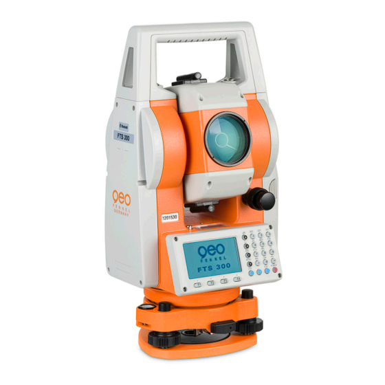
- Page 1 FTS 300 TOTALSTATION User Manual Totalstation FTS 300...
-
Page 2: Foreword
FOREWORD FOREWORD Thank you for purchasing the geo-FENNEL Electronic Total Station, FTS 300 series. For the best performance of the instruments, please carefully read these instructions and keep them in a convenient location for future reference. General Handling Precautions Before starting work or operation, be sure to check that the instrument is functioning correctly with normal performance. -
Page 3: Display For Safe Use
• There is a risk of fire, electric shock or physical harm if you attempt to disassemble or repair the instrument yourself. This is only to be carried out by geo-FENNEL or an authorized dealer, only! • Cause eye injury or blindness. -
Page 4: User
5)The manufacturer, or its representatives, assumes no responsibility for any damage, and loss of profits caused by usage except for explained in the user manual. 6)The manufacturer, or its representatives, assumes no responsibility for damage caused by wrong movement, or action due to connecting with other products. www.geo-fennel.de... -
Page 5: Table Of Contents
Area Calculation Point to Line Measurement Setting the GRID FACTOR Setting Illumination of Display and Cross Hairs Setting Mode1 Setting Minimum Reading Auto Power Off Vertical Angle Tilt correction( Tilt ON/OFF) Heater ON/OFF Setting RS232-C communication with external device www.geo-fennel.de... - Page 6 Coordinate data input PTL (Point to Line) data input Delete a Coordinate Data from a File Editing PCODE Library Data Communications Sending Data Loading Data Setting Parameter of Data Communications 10. SET AUDIO MODE 11. SETTING THE PRISM CONSTANT VALUE www.geo-fennel.de...
- Page 7 Collimation of the Instrument Checking/Adjusting the Optical Plummet Telescope Adjustment of Vertical Angle 0 Datum How to Set the Instrument Constant Value Reference frequency check mode 18. PRISM SYSTEM 19. ERROR DISPLAYS 20. SPECIFICATIONS APPENDIX Precaution when Charging or Storing Batteries www.geo-fennel.de...
-
Page 8: Nomenclature And Functions
1 NOMENCLATURE AND FUNCTIONS 1 NOMENCLATURE AND FUNCTIONS NOMENCLATURE AND FUNCTIONS 1.1 Nomenclature Handle locking screw Objective lens Instrument center mark Optical plummet Display unit telescope Serial signal connector Circular level Adjustment screw for circular level Leveling screw Base Tribrach fixing lever www.geo-fennel.de... - Page 9 On-board battery BT-G1 Telescope eyepiece Instrument center mark *Vertical motion clamp *Vertical tangent screw Horizontal tangent screw Plate level Horizontal Display unit motion clamp *The position of vertical motion clamp and Vertical tangent screw will differ depending on the market. www.geo-fennel.de...
-
Page 10: Display
Relative elevation : 12.34ft Relative elevation : 12ft3in4/8in • Display marks Contents Contents Display Display V-angle EDM working H-angle right Meter unit Feet and inch unit H-angle left Horizontal distance Relative elevation Slope distance N coordinate E coordinate Z coordinate www.geo-fennel.de... -
Page 11: Operating Key
It is also possible to use as Record key in normal measurement mode. To select function of Escape key, see Chapter 16 “SELECTING MODE” Enter key Press at the end of inputting values. Soft key F1–F4 Responds to the message displayed. ( Function key) www.geo-fennel.de... -
Page 12: Function Key (Soft Key)
The function of soft keys is shown on next page (P2). OFSET Select Off-set measurement mode Select stake out measurement mode m/f/i Switches meter, feet or feet and inch unit. The function of soft keys is shown on next page (P1). www.geo-fennel.de... -
Page 13: Star Key Mode
(PPM) and correction value of prism constant (PSM) are displayed. Adjust the contrast of the display (0 to 9 steps) Adjust the Reticle Illumination (1 to 9 steps) ON/OFF of the reticle illumination is linked with ON/OFF of the backlight. www.geo-fennel.de... -
Page 14: Serial Signal Rs232-C Connector
Serial signal RS-232C connector The serial signal connector is used for connecting the GTS-100N series with a computer or TOPCON FTS 300 geo-FENNEL Data Collector, which enables the computer to receive measured data from the GTS-100N series or to FTS 300 send preset data of horizontal angle, etc. -
Page 15: Preparation For Measurement
Mount the instrument to the tripod. Level and center the instrument precisely to insure the best performance. Use tripods with a tripod screw of 5/8 in. diameter and 11 threads per inch, such as the Type E TOPCON wide- frame wooden tripod. geo-FENNEL Reference: Leveling and Centering the Instrument 1. Setting up the Tripod Rotate the instrument 90°... -
Page 16: Power Switch Key On
2.2 Power Switch Key ON Confirm the instrument is leveled. Turn the power switch ON. Power switch key ON geo-FENNEL FTS 300 Battery Power Remaining Display • Confirm the battery power remaining display. Replace with charged battery or charge when battery level is low or indicates “Battery empty”. -
Page 17: Battery Power Remaining Display
It may happen that the mode change from the angle mode to the distance mode will stop the operation because of insufficient battery power for the distance mode which consumes more power than angle mode. www.geo-fennel.de... -
Page 18: Vertical Angle Tilt Correction
( Tilt ON/OFF)” . The display of Vertical angle is unstable when instrument is on an unstable stage or a windy day. • You can turn off the auto tilt correction function of V angle in this case. www.geo-fennel.de... - Page 19 [ESC] • The setting mode performed here will not be memorized after powering OFF. To set TILT correction in the initialized setting ( it is memorized after powering OFF), see Section 6.4.3“Vertical Angle Tilt correction ( Tilt ON/OFF)” . www.geo-fennel.de...
-
Page 20: How To Enter Alphanumeric Characters
•How to select a item [Example setting] Occupied point in the data collection mode. The arrow indicates a item to enter. The arrow line moves up or down when the ] key or [ ] key is pressed. Alphanumeric characters key www.geo-fennel.de... - Page 21 2 PREPARATION FOR MEASUREMENT 2 PREPARATION FOR MEASUREMENT •How to enter characters [Example setting] TOPCON-1 geo-FENNEL Move the arrow to enter a item using the [ or [ ] key. Press the [F1] (INPUT) key. The arrow changes to the equal (=) .
-
Page 22: Angle Measurement
Focusing knob vertically or horizontally while looking Telescope eyepiece (Diopter ring) into the telescope, focusing is incorrect diopter adjustment is poor. This adversely affects precision in measurement or survey Eliminate the parallax by carefully focusing and using diopter adjustment. www.geo-fennel.de... -
Page 23: Switching Horizontal Angle Right/Left
Press the [F2](HOLD) key. [F2] Collimate the target. Collimate Press the [F3](YES) key to finish holding the [F3] horizontal angle.*1) The display turns back to normal angle measurement mode. *1) To return to the previous mode, press the [F4](NO) key. www.geo-fennel.de... -
Page 24: Setting A Horizontal Angle From The Keys
Press the [F4]( ) key to get the function on page 2. [F4] Press the [F3](V%) key. *1) [F3] *1) Every time pressing the [F3](V%) key, the display mode switches. When the measurement is carried out over ±45° (±100%) from the horizontal, the display shows • <OVER>. www.geo-fennel.de... -
Page 25: Repetition Angle Measurement
[F3](REL)key. [F3] Recollimate target B using the horizontal clamp Collimate B and tangent screw, and press the [F4](HOLD) key. [F4] Repeat 7 to 8 to measure the desired number of repetitions. [Example] 4 measurement www.geo-fennel.de... -
Page 26: Buzzer Sounding For Horizontal Angle °90 Increment
Press the [F4]( ) key twice to get the function [F4] on page 3. twice Press the [F1](H-BZ) key. [F1] The data previously set is shown. Press the [F1](ON) key or [F2](OFF) key to select [F1] or [F2] the buzzer ON/OFF. Press the [F4](ENTER) key. [F4] www.geo-fennel.de... -
Page 27: Compasses (Vertical Angle)
0° 0° -90° Operating procedure Operation Display Press the [F4]( ) key twice to get the function [F4] on page 3. twice Press the [F3](CMPS) key. *1) [F3] *1) Every time pressing the [F3](CMPS) key, the display mode switches. www.geo-fennel.de... -
Page 28: Distance Measurement
4.2 Setting of the Correction for Prism Constant Topcon’s prism constant value is 0. Set correction for prism at 0. If the prism is of another manufacture, geo-FENNEL’s the appropriate constant shall be set beforehand. Refer to Chapter 11 “SETTING THE PRISM CONSTANT VALUE”. -
Page 29: Distance Measurement (N-Time Measurement/Single Measurement)
*1) It is possible to set the measurement mode for N-times measurement mode or continuous measurement mode when the power is turned on. Refer to Chapter 16 “SELECTING MODE”. *2) For setting the number of times (N-times) in the measurement, refer to Chapter 16 “SELECTING MODE”. www.geo-fennel.de... -
Page 30: Fine Mode/Tracking Mode/Coarse Mode
Press the [F2](MODE) key from the distance [F2] measuring mode.*1) The initial character (F/T/C) of set mode is displayed . (F:Fine, T:Tracking, C:Coarse) Press the [F1](FINE) key, [F2](TRACK) key, or [F1]~[F3] [F3](COARSE) key. *1) To cancel the setting, press the [ESC] key. www.geo-fennel.de... -
Page 31: Stake Out (S.o)
Move the target until the difference becomes 0m. *1) Refer to section 2.5 “How to Enter Alphanumeric characters”. To return to normal distance measurement mode, stake out distance to "0" m or turn the power off. www.geo-fennel.de... -
Page 32: Offset Measurement
Refer to Chapter 16 “SELECTING MODE” to set this option. [F3] Distance measurement mode of the offset measurement Offset measurement will be done by N-time fine measurement mode. For setting measuring times refer to Chapter 16 “SELECTING MODE”. www.geo-fennel.de... -
Page 33: Angle Offset
Press the [F4](P1 ) key from distance measuring [F4] mode to get the function on page 2. Press the [F1](OFSET) key. [F1] Press the [F1](ANG. OFFSET) key. [F1] Collimate prism P, and press the [F1](MEAS) key. Collimate P [F1] www.geo-fennel.de... - Page 34 Show N coordinate of point A or A Each time pressing [ ] key, N,E and Z coordinate are shown in sequence. To return to procedure , press [F1](NEXT) key. To return to the previous mode, press [ESC] key. www.geo-fennel.de...
-
Page 35: Distance Offset Measurement
Press the [F1](OFSET) key. [F1] Press the [F2](DIST. OFFSET) key. [F2] Enter Right and Left direction offset value, and Enter HD press the [F4](ENTER) key. [F4] Enter a Forward direction offset value, and press Enter HD the [F4](ENTER) key. [F4] www.geo-fennel.de... - Page 36 Each time pressing the [ ] key, horizontal distance, relative elevation and slope distance are shown in sequence. Show coordinate of point P0. To return to procedure , press [F1](NEXT) key. To return to the previous mode, press [ESC] key. www.geo-fennel.de...
-
Page 37: Plane Offset Measurement
Press the [F3](PLANE OFFSET) key. [F3] Collimate prism P1, and press the [F1](MEAS) Collimate key. N-time measuring will start. [F1] After measuring, the display will show the second point measurement. Measure the second and third points in the same Collimate way. [F1] 4-10 www.geo-fennel.de... - Page 38 *2) Data display is the mode beforehand of offset measurement mode. *3) Error will be displayed when collimated to the direction which does not cross with the determined plane. *4) The refrector height of the target point P0 is set to zero automatically. 4-11 www.geo-fennel.de...
-
Page 39: Column Offset Measurement
2. Press the [F1](OFSET) key. [F1] Press the [F4](P ) key. [F4] Press the [F1](COLUMN OFFSET) key. [F1] Collimate the center of the column (P1) and press Collimate the [F1](MEAS) key. N-time measuring will start. [F1] 4-12 www.geo-fennel.de... - Page 40 ] key, horizontal distance, relative elevation and slope distance are shown in sequence. To show coordinate of point P0, press the [ key. To escape the measuring, press the [ESC] key. The display returns to the previous mode. 4-13 www.geo-fennel.de...
-
Page 41: Coordinate Measurement
After entering the values, the display returns coordinate measuring display. *1) Refer to Section 2.5 “How to Enter Alphanumeric characters”. < < •Input range –9999999.9990 N,E,Z +99999999.9990m < < –9999999.999 N,E,Z +99999999.999 ft. < < –9999999.11.7 N,E,Z +99999999.11.7 ft.+inch www.geo-fennel.de... -
Page 42: Setting Height Of The Instrument
Enter the prism height. *1) Enter R.HT [F4] *1) Refer to Section 2.5 “How to Enter Alphanumeric characters”. < < •Input range –999.9999 Prism height +999.9999 m < < –999.999 Prism height +999.999 ft. < < –999.11.7 Prism height +999.11.7 ft.+inch www.geo-fennel.de... -
Page 43: Execution Of Coordinate Measuring
•In case the coordinate of instrument point is not entered, (0,0,0) will be used as the default for the instrument point. •The instrument height will be calculated as 0 when the instrument height is not entered. •The prism height will be calculated as 0 when the prism height is not set. www.geo-fennel.de... -
Page 44: Special Mode (Menu Mode)
"LAYOUT MODE" [F4] See Chapter 8 “LAYOUT”. [F3] "MEMORY MANAGER MODE" See Chapter 9 “MEMORY MANAGER MODE”. Programs [ESC] [ESC] [F1] Grid factor [F4] [F2] Reticle illumination [F3] Setting mode 1 [ESC] [F1] [ESC] [F4] Display contrast adjustment [F2] www.geo-fennel.de... -
Page 45: Application Measurement (Programs)
2. [F4] Press the [F1] key. [F1] Press the [F1](REM) key. [F1] Press the [F1] key. [F1] Enter prism height. *1) Enter R.HT [F4] Collimate P Collimate prism. Press the [F1](MEAS) key. [F1] Measuring starts. www.geo-fennel.de... - Page 46 2. [F4] Press the [F1] key. [F1] Press the [F1](REM) key. [F1] Press the [F2] key. [F2] Collimate prism. Collimate P Press the [F1](MEAS) key. [F1] Measuring starts. Horizontal distance (HD) between the instrument and prism will be shown. www.geo-fennel.de...
- Page 47 Collimate target K. Collimate K Vertical distance (VD) will be shown. *2) *1) To return to procedure , press the [F3](HD) key. To return to procedure , press the [F2](V) key. *2) To return to PROGRAMS Menu, press the [ESC] key. www.geo-fennel.de...
-
Page 48: Missing Line Measurement (Mlm)
After pressing the [MENU] key, press the [F4](P ) [MENU] key to get the menu on page 2. [F4] Press the [F1] key. [F1] Press the [F2](MLM) key. [F2] Press the [F1] or [F2] key to select using [F2] coordinate file. [Example:F2 : DON’T USE] www.geo-fennel.de... - Page 49 After measuring, the horizontal distance (dHD) [F4] and relative elevation (dVD) between prism A and C will be shown. To measure the distance between points A and D, repeat procedure 12 to14. *1) *1) To return to previous mode, press the [ESC] key. www.geo-fennel.de...
- Page 50 Point number input display will be shown. Pressing the [F3](HD) key, the display will return to procedure After selecting coordinate input mode by pressing the [F3](NEZ or PT# or HD) key, press the [F1](INPUT) key and enter the data. www.geo-fennel.de...
-
Page 51: Setting Z Coordinate Of Occupied Point
Press the [F1](INPUT) key and enter the Point [F1] number. Instrument height setting display will be Enter PT# shown. [F4] Enter the height. Enter HT [F4] The display returns to Z coordinate menu. •For more information about data file, see Chapter 9 “MEMORY MANAGER MODE” . www.geo-fennel.de... - Page 52 [F4] Press the [F3](YES) key and enter the Point [F3] Number in coordinate data file. Enter the height. Enter R. HT [F4] Collimate a prism on the point and press the Collimate P [F3](YES) key. [F3] Measuring starts. *1) www.geo-fennel.de...
- Page 53 Horizontal angle will be set. The display returns to Programs 1/2 menu. *1) Measurement is Fine N-times measurement mode. *2) To measure other points, press the [F1](NEXT) key. *3) Pressing the [F3] key, the display will be changed alternately. 6-10 www.geo-fennel.de...
-
Page 54: Area Calculation
Initial display will be shown. [F4] Press the [F4](NEXT) key. *1),2) [F4] The top of the file data (DATA-01) will be set and the second point number will be shown. Repeat pressing the [F4](NEXT) key to set [F4] required number of points. 6-11 www.geo-fennel.de... - Page 55 Press the [F1] or [F2] key to select using GRID [F2] FACTOR. [Example:F2 : DON’T USE] Collimate a prism and press the [F1](MEAS) key. Collimate P Measuring starts. *1) [F1] Collimate next point and press the [F1](MEAS) Collimate key. [F1] 6-12 www.geo-fennel.de...
- Page 56 It is possible to change the displayed area unit. Operating procedure Operation Display Press the [F3](UNIT) key. [F3] Select a unit by pressing the [F1] to [F4] key. [F2] Example: [F2](ha) key. •m.sq : square meter ha : hectare ft.sq : square feet acre : acre. 6-13 www.geo-fennel.de...
-
Page 57: Point To Line Measurement
[F4] Press the [F1] key. [F1] Press the [F4](P ) key to get the PROGRAMS [F4] menu on page 2/2. Press the [F2] key. [F2] Enter instrument height. Enter INS.HT [F4] Enter reflector A(P1) height. Enter R.HT [F4] 6-14 www.geo-fennel.de... - Page 58 *1) Measurement is Fine N-times measurement mode. *2) To show dSD, press [F4](P ) key. *3) To show the new occupied data, press [F2](S.CO) key. *4) Measurement is Fine N-times measurement mode. *5) To return to previous mode, press [F1](EXIT) key. 6-15 www.geo-fennel.de...
-
Page 59: Setting The Grid Factor
Note: Calculation of Z coordinate is not influenced even if it is applied to grid factor. Operating procedure Operation Display After pressing the [MENU] key, press the [F4](P ) [MENU] key to get the menu on page 2. [F4] Press the [F2](GRID FACTOR) key. [F2] 6-16 www.geo-fennel.de... -
Page 60: Setting Illumination Of Display And Cross Hairs
The data previously set is shown. Press the [F3](LEVEL) key. [F3] Press the [F2]( ) key, and then press the [F2] [F4](ENTER) key. [F4] Press the [F1](ON) key. [F1] •To return to previous mode, press the [ESC] key. 6-17 www.geo-fennel.de... -
Page 61: Setting Mode1
Press the [F1] key. [F1] Press the [F2](5") key and press the [F4](ENTER) [F2] key. [F4] Press the [F2] key. [F2] Press the [F1] key and press the [F4](ENTER) key. [F1] [F4] •To return to previous mode, press the [ESC] key. 6-18 www.geo-fennel.de... - Page 62 Press the [F1] key. [F1] Press the [F3] key. [F3] The data previously set is shown. If already ON, the display shows tilt correction value. Press the [F1](X-ON) key or [F3](OFF) key, and [F1], [F3] press the [F4](ENTER) key. [F4] 6-19 www.geo-fennel.de...
-
Page 63: Heater On/Off
[F4] Press the [F1] key. [F1] Press the [F4] key. [F4] Press the [F2] key. [F2] The data previously set is shown. Press the [F1](ON) key or [F2](OFF) key, and [F1] or [F2] press the [F4](ENTER) key. [F4] 6-20 www.geo-fennel.de... -
Page 64: Setting Rs232-C Communication With External Device
[F3] The data previously set is shown. Press the [F3] key to select STOP BITS. [F3] The data previously set is marked. Press the [F2](2) key to select stop bit 2, and [F2] press the [F4](ENTER) key. [F4] 6-21 www.geo-fennel.de... -
Page 65: Setting Contrast Of Display
After pressing the [MENU] key, press the [F4](P ) [MENU] key twice to get the menu on page 3. [F4] [F4] Press the [F2] key. [F2] Press the [F1]( ) key or [F2]( ) key, and press the [F1]or [F2] [F4](ENTER) key. [F4] 6-22 www.geo-fennel.de... -
Page 66: Road
6 SPECIAL MODE (Menu Mode) 6 SPECIAL MODE (Menu Mode) 6.6 ROAD •Road menu operation Press F3 key Input start point Input road data Search data Edit data Set OCC and BS Set out road Resection Select a file Initialize ROAD data 6-23 www.geo-fennel.de... - Page 67 Consequently, if the free area of the memory reaches 10% or less, a “MEMORY POOR” warning message is displayed. (In this case, the instrument can still be operated.) •CHAIN and INTERVAL input range -50,000m CHAIN +500,000m 0m<INTERVAL +5,000m 6-24 www.geo-fennel.de...
-
Page 68: Input Road Data
To input LINE data, press the [F1] key. *1) [F1] Input LENGTH. Input Press the [ENT] key. LENGTH [ENT] Input AZIMUTH. Input AZIMUTH Press the [ENT] key. [ENT] *1) The number at the top right of the screen shows the amount of data currently entered. 6-25 www.geo-fennel.de... - Page 69 Press the [ENT] key. RADIUS [ENT] Input Input LENGTH. LENGTH Press the [ENT] key. [ENT] Select [F1] (LEFT) Select TURN(direction of turn): RIGHT or LEFT. Press the [ENT] key. [F2] (RIGHT) [ENT] *1) CURVE cannot be input as the first data. 6-26 www.geo-fennel.de...
- Page 70 Select TURN(direction of turn): RIGHT or LEFT. Press the [ENT] key. [F2] (RIGHT) [ENT] Select DIR(direction): IN(entrance) or OUT(exit). Select Press the [ENT] key. [F1] (IN) [F2] (OUT) [ENT] *1) SPIRAL cannot be input as the first data. 6-27 www.geo-fennel.de...
- Page 71 *1) If the data input is not required, press the [SKIP] key. •When inputting POINT data, if the next data is not POINT data, ROAD is calculated as a straight line irrespective of the values for RADIUS, A1 and A2. 6-28 www.geo-fennel.de...
-
Page 72: Search Data
To switch to different data, press the [ ] or [ ] key. [ ]or [ ] 6.6.4 Edit Data To edit input data, carry out the following operating procedure. Operating procedure Operation Display In DATA SEARCH, press the [F1] key. [F1] Edit the data. Edit data 6-29 www.geo-fennel.de... -
Page 73: Set Occ And Bs
OCC. PT [ENT] Press the [ENT] key. [ENT] LEFT or RIGHT: Use the offset point. CENTER: Use the center point. (Example : CENTER) Press the [F3](YES) key. [F3] Input the backsight. Input Backsight Press the [ENT] key. [ENT] 6-30 www.geo-fennel.de... - Page 74 6 SPECIAL MODE (Menu Mode) Collimate the backsight. Collimate Backsight Press the [F3](YES) key. [F3] *1) When setting the Occupied Point and Backsight Point using Resection method, select [F2] (RESECTION). For details of the Resection method, refer to Section 8.3.2 “Resection Method”. 6-31 www.geo-fennel.de...
-
Page 75: Setout Road
= Actual horizontal angle - Calculated horizontal angle. Correct direction when dHR = 0°00'00" Press the [F1](DIST) key. [F1] Measuring (Actual) horizontal distance dHD: Horizontal distance to be turned to the layout point = Actual horizontal distance – Calculated horizontal distance. 6-32 www.geo-fennel.de... -
Page 76: Select A File
Press the [F3], [F3] key. [F3] (Refer to “Initialize ROAD data” on page 6-23.) [F3] When the [F4] (YES) key is pressed, all ROAD DATA with the exception of the coordinate data file is erased. [F4] Press the [F4] key. 6-33 www.geo-fennel.de... -
Page 77: Data Collection
1) When turning off the power, ensure that you are in the main menu screen or main angle measurement mode. This ensures completion of the memory access process and avoids possible damage to the stored data. 2) It is recommended for safety to charge the battery (BT-G1) beforehand and prepare fully charged spare batteries. www.geo-fennel.de... - Page 78 See Section 7.1.1 “Selecting a File for Data DATA COLLECTION MENU 2/2 Collection”. [F2] Editing PCODE library See Section 7.6 “Editing PCODE Library [PCODE INPUT]” [F3] Setting Parameter of Data Collect See Section 7.7 “Setting Parameter of Data Collect [CONFIG.]”. www.geo-fennel.de...
-
Page 79: Preparation
*2) When a file has been selected already, '*' mark is indicated on left of current file name. *3) Data in a file shown with arrow can be searched by pressing [F2](SRCH) key. •It is possible to select a file from DATA COLLECT 2/2 menu in the same way. www.geo-fennel.de... -
Page 80: Selecting A Coordinate File For Data Collection
In case of setting occupied point from the coordinate data stored in the internal memory. Operating procedure Operation Display Press the [F1](OCC.PT# INPUT) key from the [F1] data collect menu 1/2. The previous data is shown. Press the [F4] (OCNEZ) key. [F4] Press the [F1](INPUT) key. [F1] www.geo-fennel.de... - Page 81 To show the list of PCODE library, press the [F2](SRCH) key. *3) Press the [F3](REC) key when you do not input the INS.HT. •The data recorded in data collect is PT#, ID and INS.HT. •If point is not found in internal memory "PT# DOES NOT EXIST" is displayed. www.geo-fennel.de...
- Page 82 To show the list of PCODE library, press the [F2](SRCH) key. *4) Data collect sequence can be set to [MEAS EDIT]. Refer to Section 7.7 “Setting Parameter of Data Collect [CONFIG.]”. •If point is not found in internal memory " PT# DOES NOT EXIST" is displayed. www.geo-fennel.de...
- Page 83 Press the [F1](INPUT) key and enter PT#. [F1] Press the [F4](ENT) key. *1) Enter PT# [F4] Enter PCODE, R.HT in the same way. *2),3) [F1] Enter geo-FENNEL PCODE [F4] [F1] Press the [F3](MEAS) key. EnterR.HT [F4] Collimate the target point.
- Page 84 *1) It is possible to see the PCODE list when the arrow is located beside PCODE or ID. *2) The operation is same as the "SEARCH" in the MEMORY MANAGER mode. For more information, refer to Section 9.2 “Searching Data”. www.geo-fennel.de...
- Page 85 [F4](ENT) key. Enter No (Example) [F4] Register number, 32 = TOPCON geo-FENNEL geo-FENNEL •Entering PCODE / ID from the list of PCODE You can also enter PCODE / ID from the list of PCODE. Operating procedure Operation...
-
Page 86: Data Collect Offset Measurement Mode
To set this option, refer to Chapter 16 “SELECTING MODE”. Instrument height Occ.Point Operating procedure Operation Display Press the [F3](MEAS) key. [F3] geo-FENNEL Press the [F4](P1 ) key, [F1](OFSET) key. [F4] [F1] Press the [F1] key. [F1] Collimate the prism. Collimate P Press the [F3](YES) key. - Page 87 Show N coordinate of point A0 or A1. •Each time pressing [ ] key, N,E and Z coordinate are shown in sequence. Press the [F3](YES) key. [F3] geo-FENNEL The data is recorded and the next measuring point is displayed. 7-11 www.geo-fennel.de...
-
Page 88: Distance Offset Measurement
When measuring coordinates of point A Set the instrument height only. (Set the prism height to 0 ). Operating procedure Operation Display geo-FENNEL Press the [F3](MEAS) key. [F3] Press the [F4](P1 ) key, [F1](OFSET) key. [F4] [F1] Press the [F2] key. - Page 89 7 DATA COLLECTION Collimate the prism. Collimate P Press the [F2] or [F3] key. [F3] Example:[F3](NEZ) key Measuring starts. The data is recorded and the next measuring point is displayed. geo-FENNEL *1) To skip entering, press the [F3](SKP) key. 7-13 www.geo-fennel.de...
-
Page 90: Plane Offset Measurement
(Point without prism) (Prism) (Prism) Prism heights of P1 to P3 is set to zero automatically. Operating procedure Operation Display geo-FENNEL Press the [F3](MEAS) key. [F3] Press the [F4](P1 ) key, [F1](OFSET) key. [F4] [F1] Press the [F3](PLANE OFFSET) key. [F3]... - Page 91 Collimate [F1] The display changes to PT# input in the plane offset measurement. *1) Input point number if necessary. geo-FENNEL Press the [F4](MEAS) key. [F4] The instrument calculates and displays coordinate and distance value of cross point between collimation axis and of the plane. *2) Collimate the edge (P0) of the plane.
-
Page 92: Column Offset Measurement
The direction angle of the center of the column is 1/2 of total direction angle of circumscription points (P2) and (P3). Prism Operating procedure Operation Display geo-FENNEL Press the [F3](MEAS) key. [F3] Press the [F4](P1 ) key, [F1](OFSET) key. [F4] [F1] Press the [F4](P1 ) key. -
Page 93: Nez Auto Calculation
Press the [F3](YES) key. The display returns to [F3] the next point number in data collect mode. geo-FENNEL NEZ Auto Calculation As measured data is collected, coordinates are calculated and stored for traverse or topo collection. Automatic making out function of coordinate data sets up in CONFIG of data collect. Refer to Section 7.7 “Setting Parameter of Data Collect [CONFIG.]”. -
Page 94: Point To Line Measurement
(PT#PTL) OCC.PT Offset 7.5.1 To change to the point to line measurement Operating procedure Operation Display geo-FENNEL Press the [F3](MEAS) key and press the [F4]key [F3] to get to the next soft key page. [F4] geo-FENNEL Press the [F2](PTL) key. -
Page 95: Executing A Point To Line Measurement
Display Conduct data measurement according to the same procedure as with ordinary FS/SS (ALL can also be geo-FENNEL selected). However, when you conduct observation in the angle mode, PTL data will not be displayed (only the raw data will be recorded, upon which the operation will end). -
Page 96: Editing Pcode Library [Pcode Input]
PCODE can be also edited in MEMORY MANAGER menu 2/3 in the same way. Operating procedure Operation Display Press the [F2](PCODE INPUT) key from Data [F2] Collect menu 2/2. geo-FENNEL By pressing the following keys, the list will ]or[ increase or decrease. ]or[ ] or[ ] : Increasing or Decreasing one by one ]or[ ] : By ten Increasing or Decreasing. -
Page 97: Setting Parameter Of Data Collect [Config]
The CONFIG menu 1/2 is shown. Press the [F4](P ) key to display the CONFIG [F4] menu 2/2. Press the [F1] (DATA CONFIRM) key. [F1] [ ] indicates the current setting. Press the [F1] (YES) key. [F1] Press the [F4] (ENTER) key. [F4] 7-21 www.geo-fennel.de... -
Page 98: Layout
This ensures completion of the memory access process and avoids possible damage to the stored data. 2) It is recommended for safety to charge the battery (BT-G1) beforehand and prepare fully charged spare batteries. 3) When recording new point data, remember to consider the amount of internal memory available. www.geo-fennel.de... - Page 99 : If you do not want to create or reselect a file. [F4](ENTER) : To select display file. [F3]/[F4] OCC.PT INPUT [ESC] [F1] LAYOUT MENU 1/2 BACKSIGHT [F2] LAYOUT [F4] [F3] SELECT A FILE [ESC] [F1] LAYOUT MENU 2/2 NEW POINT [F2] GRID FACTOR [F3] www.geo-fennel.de...
-
Page 100: Preparation
Grid Factor is displayed for 1 to 2 second and [F4] display returns to Layout menu 2/2. *1) Refer to Section 2.5 “How to Enter Alphanumeric characters”. •Input Range :Elevation : –9,999 to +9,999 meter (–32,805 to +3,2805 ft, ft+in) Scale Factor : 0.990000 to 1.010000 www.geo-fennel.de... -
Page 101: Selecting Coordinate Data File
*2) When a file has been selected already, ‘*’ mark is indicated on left of current file name. For the file discrimination mark (*, @, &), refer to Section 9.3 “FILE MAINTENANCE”. *3) Data in a file shown with arrow can be searched by pressing the [F2](SRCH) key. www.geo-fennel.de... -
Page 102: Setting Occupied Point
Enter Instrument Height in the same way. Enter INS.HT [F4] The display returns to layout menu 1/2. *1) Refer to Section 2.5 “How to Enter Alphanumeric characters”. *2) It is possible to record the coordinate value. Refer to Chapter 16 “SELECTING MODE”. www.geo-fennel.de... -
Page 103: Setting Backsight Point
Sight the backsight point and press the [F3](YES) Sight BK key. [F3] The display returns to the layout menu 1/2. *1) Refer to Section 2.6 "How to enter alphanumeric characters". •With each pressing of [F3] key, method of inputting backsight is changed. [F3](NE/AZ) [F3](AZ) [F3](PT#) www.geo-fennel.de... - Page 104 Sight BK Press the [F3](YES) key. [F3] The display returns to the layout menu 1/2. *1) Refer to Section 2.5 “How to Enter Alphanumeric characters”. *2) It is possible to record the coordinate value. Refer to Chapter 16 “SELECTING MODE”. www.geo-fennel.de...
-
Page 105: Executing A Layout
Horizontal distance to be turned to the layout point = Actual horizontal distance – Calculated horizontal distance. Vertical distance to be turned to the layout point = Actual vertical distance – Calculated vertical distance. Press the [F1](MODE) key. [F1] The fine mode measuring starts. www.geo-fennel.de... - Page 106 *1) Refer to Section 2.5 “How to Enter Alphanumeric characters”. *2) Point number could not be entered when data to comply with the coordinate value does not exist in the file. *3) Cut & Fill displaying function is available . Refer to Chapter 16 “SELECTING MODE”. www.geo-fennel.de...
-
Page 107: Layout Of Coordinates Of Point To Line
Vertical distance to be turned to the layout point = Actual vertical distance – Calculated vertical distance. Press the [F2](PTL) key. [F2] The difference between Collimation point and Layout point distance on the coordinate system of the line determined will be displayed. 8-10 www.geo-fennel.de... -
Page 108: Setting A New Point
[F2] Press the [F1](SIDE SHOT) key. [F1] Press the [F2](LIST) key to display the list of [F2] coordinate data file. *1) Scroll file list by pressing [ ]or[ ] key and select ]or[ a file to use. *2),3) 8-11 www.geo-fennel.de... - Page 109 For the file discrimination mark (*, @, &), refer to Chapter 9.3 “FILE MAINTENANCE”. *3) Data in a file shown with arrow can be searched by pressing [F2](SRCH) key. *4) Refer to Section 2.5 “How to Enter Alphanumeric characters”. *5) An error will be displayed when the internal memory is full. 8-12 www.geo-fennel.de...
-
Page 110: Resection Method
Press the [F4]( ) key from the layout menu 1/2 to [F4] get the layout menu 2/2. Press the [F2](NEW POINT). [F2] Press the [F2](RESECTION) key. [F2] Press the [F1](INPUT) key, and enter the new [F1] point name. *1) ,2) Enter PT# Press the [F4](ENT) key. [F4] 8-13 www.geo-fennel.de... - Page 111 Select GRID FACTOR for calculation of [F1] RESIDUAL ERROR by pressing [F1] or [F2] key. *5) Example: [F1] Press the [F1](NEXT) key to measure other points. [F1] Maximum seven points can be measured. Same as procedure proceed to the known point C. 8-14 www.geo-fennel.de...
- Page 112 *7) The display shows ">SET ?" when [F3](SKP) key pressed in step . In this case, the new point data is not stored into the coordinate data file, only the value of occupied coordinate data changes to that of the calculated NEW POINT. 8-15 www.geo-fennel.de...
- Page 113 Press the [F4] (ENTER) key. [F4] The selected point number is set as PT#. • The operation of [F2]( SRCH) is same as the "SEARCH" in the MEMORY MANAGER MODE. For more information, refer to Chapter 9 “MEMORY MANAGER MODE”. 8-16 www.geo-fennel.de...
-
Page 114: Memory Manager Mode
By pressing the [MENU] key, the instrument will be in MENU 1/3 mode. Press the [F3](MEMORY MGR. ) key, the menu of MEMORY MGR. 1/3 will be shown. Normal measurement mode [MENU] [ESC] [ESC] [F3] MEMORY MGR. MENU 1/3 [F4] MEMORY MGR. MENU 2/3 [F4] MEMORY MGR. MENU 3/3 [F4] www.geo-fennel.de... -
Page 115: Display Internal Memory Status
*1) Each coordinate file has one extra data for working area. •The FILE/DATA STATUS display will change alternately by pressing [F4]( P ) key. •To return to MEMORY MGR. menu press the [ESC] key. www.geo-fennel.de... -
Page 116: Searching Data
*2) To show the file list, press the [F2](LIST) key. •" " represents data shown on the display is the stored data. •Press the [ ]or[ ] key to scroll to next or previous point. •To search MEAS. DATA of the same point number, press[ ]or[ ] key. www.geo-fennel.de... - Page 117 Press the [F3](YES) key . [F3] *1) Refer to Section 2.5 “How to Enter Alphanumeric characters”. •When editing, ID and PCODE are not linked with PCODE LIBRARY. •Even though the height data (INS.HT, R.HT) are corrected, the measured value can not be corrected. www.geo-fennel.de...
-
Page 118: Coordinate Data Searching
•Press the [ ] or [ ] key to scroll to next or previous point. •To search COORD. DATA of the same point number, press the [ ] or [ ] key. •PTL data will be shown below. [F4] www.geo-fennel.de... -
Page 119: Pcode Library Searching
*1) Refer to Section 2.5 “How to Enter Alphanumeric characters”. •Press the [ ] or [ ] key to scroll to next or previous PCODE data. *2) To correct the PCODE data , press the [F1](EDIT) key. To delete the PCODE data, press the [F3](CLR) key. www.geo-fennel.de... -
Page 120: File Maintenance
“ M ” :Measured data “ C ” :Coordinate data. Four figures means the total number of data in the file. (Coordinate data file has an extra data for working.) Press the [ ] or [ ] key to scroll to next file. www.geo-fennel.de... -
Page 121: Rename A File
Select searching method by pressing the [F1] to [F1] to [F3] [F3] key. *1) *1) Because procedures from next are same as procedures of Section 9.2 "Searching Data", refer to Section 9.2 “Searching Data” To return to the FILE MAINTAN. Menu , press the [ESC] key. www.geo-fennel.de... -
Page 122: Deleting A File
Memory manager menu 1/3. Select a file to delete by pressing [ ]or[ ] key. ]or[ Press the [F3](DEL) key. [F3] Confirm the deleting, and press the [F4](YES) key. [F4] •To return to the FILE MAINTAN. Menu , press the [ESC] key. www.geo-fennel.de... -
Page 123: Coordinate Data Directkey Input
Enter data Press the [F4](ENT) key. *1) [F4] Enter PCODE and press the [F4](ENTER). [F1] Enter PCODE geo-FENNEL Next input display is shown, point number (PT#) is [F4] automatically incremented. *1) Refer to Section 2.5 “How to Enter Alphanumeric characters”. 9-10... -
Page 124: Ptl (Point To Line) Data Input
E: Elevation Enter PCODE , FROM and TO data and press the [F1] [F4](ENTER).*2) Enter PCODE geo-FENNEL [F4] Next input display is shown, point number (PT#) is automatically incremented. *1) Refer to Section 2.5 “How to Enter Alphanumeric characters”. *2) When the inputted point name data as FROM or TO, does not exist in the same file, an error will be displayed. -
Page 125: Delete A Coordinate Data From A File
[F1] Press the [F4](ENT) key. *1) Enter PT# [F4] Confirm the data and press the [F3](YES) key. [F3] Deleting starts. The display will return to the previous display. *1) Refer to Section 2.5 “How to Enter Alphanumeric characters”. 9-12 www.geo-fennel.de... -
Page 126: Editing Pcode Library
Press the [F3](MEMORY MGR. ) key from the [F3] menu 1/3. Press the [F4](P ) key. [F4] Press the [F3](PCODE INPUT) key. [F3] geo-FENNEL By pressing the following keys, the list will ]or[ increase or decrease. ]or[ ]or[ ] :Increasing or Decreasing one by one ]or[ ] :By ten Increasing or Decreasing. -
Page 127: Data Communications
*1) Refer to Section 2.5 “How to Enter Alphanumeric characters”. *2) To scroll the data, press the [ ]or[ ] key. •To show the file list, press the [F2](LIST) key. *3) To cancel the sending, press the [F4](STOP) key. 9-14 www.geo-fennel.de... -
Page 128: Loading Data
Enter FN key. *1) [F4] Press the [F3](YES) key.*2) [F3] The loading starts. The display will return to menu. *1) Refer to Section 2.5 “How to Enter Alphanumeric characters”. *2) To cancel the loading, press the [F4](STOP) key. 9-15 www.geo-fennel.de... -
Page 129: Setting Parameter Of Data Communications
Press the [F2](BAUD RATE) key. [F2] ] indicates present setting. Select the items by pressing [ ]or[ ] , [ and [ ] keys. *1) Press the [F4](ENTER) key. [F4] *1) To cancel setting, press the [ESC] key. 9-16 www.geo-fennel.de... - Page 130 Press the [F2](INITIALIZE) key. [F2] Select the data to initialize by pressing one of the [F3] [F1] to [F3] key. Example : [F3](ALL DATA) Confirm the erase data, press the [F4](YES) key. [F4] Initializing will start. The display returns to menu. 9-17 www.geo-fennel.de...
-
Page 131: Set Audio Mode
•When receiving reflected light, buzzer sounds. It is possible to stop the sound, see Chapter 16 “SELECTING MODE” . •The [F1] to [F3] keys are used for setting atmospheric correction and prism constant. •To return to normal measuring mode, press the [ESC] key. 10-1 www.geo-fennel.de... -
Page 132: Setting The Prism Constant Value
11 SETTING THE PRISM CONSTANT VALUE SETTING THE PRISM CONSTANT VALUE The prism constant value of geo-FENNEL is set to zero.When using prisms other than geo-FENNEL,it is The prism constant value of Topcon is set to zero. When using prisms other than Topcon’s, it is... -
Page 133: Setting Atmospheric Correction
Pres. 560 to 1066.0hPa (0.1hPa step) ,420 to 800mmHg (0.1mmHg step) or 16.5 to 31.5inHg (0.1inHg step) • When the atmospheric correction value which is calculated from the input temperature and pressure values exceeds the range ± 999.9ppm, the operating procedure returns to step automatically. Input values again. 12-1 www.geo-fennel.de... - Page 134 Press the [F2](PPM) key. [F2] Current setting value is displayed. Enter atmospheric correction value. *1) Enter Data [F4] Mode returns to Set Audio mode. *1) Refer to Section 2.5 “How to Enter Alphanumeric characters”. •Input range : –999.9ppm to +999.9ppm,0.1ppm step 12-2 www.geo-fennel.de...
- Page 135 Read the value from the diagonal line, which represents the required atmospheric correction value. Example: The measured temperature is +26°C The measured pressure is 1013 hPa There fore, The correction value is +10ppm 12-3 www.geo-fennel.de...
- Page 136 12 SETTING ATMOSPHERIC CORRECTION 12 SETTING ATMOSPHERIC CORRECTION 12-4 www.geo-fennel.de...
- Page 137 12 SETTING ATMOSPHERIC CORRECTION 12 SETTING ATMOSPHERIC CORRECTION 12-5 www.geo-fennel.de...
-
Page 138: Correction For Refraction And Earth Curvature
The conversion formula for horizontal and vertical distances is as follows when correction for refraction and earth curvature is not applied. • • Note: The coefficient of the instrument has been set at 0.14 before shipment (K=0.14). if the "K" value is to be changed, refer to 16 “SELECTING MODE”. 13-1 www.geo-fennel.de... -
Page 139: Power Source And Charging
Yellow lamp will illuminate and discharging will start by pressing the refresh (discharge) switch. Red quick flashing : Abnormal outbreaks Red lamp will flash when the battery life is over or the battery is broken down. Replace the battery to new one. 14-1 www.geo-fennel.de... - Page 140 If you allow the battery to be completely discharged, it will have an effect on the overall performance for proper charging in the future. Keep batteries charged at all times. For further information, see APPENDIX 2 “Precaution when Charging or Storing Batteries”. 14-2 www.geo-fennel.de...
-
Page 141: Detach/Attach Of Tribrach
The tribrach locking lever can be locked, to prevent it be accidentally removed, especially if the upper instrument section is not being detached very often. Simply tighten the securing screw on the locking lever with the accessory screwdriver, found in the case. 15-1 www.geo-fennel.de... -
Page 142: Selecting Mode
Layout Menu from normal measuring mode directly. REC: While executing normal or offset measuring, the measuring data can be output. OFF: Returns to normal function. COORD. ON / OFF Select coordinate displaying ON or OFF when CHECK setting a point. 16-1 www.geo-fennel.de... - Page 143 Set the procedure of the communication with OMITTED external device. STANDARD:Normal procedure OMITTED:Even though the [ACK] is omitted from the external device, the data is not sent again. GRID USE G.F. / Select using GRID FACTOR in calculation of FACTOR DON’T USE measurement data. 16-2 www.geo-fennel.de...
-
Page 144: How To Set Selecting Mode
Press [F1](hPa) key, and press [F4] (ENTER) key. [F1] Returns to unit set menu. [F4] Press [ESC] key. [ESC] Returns to PARAMETERS 2 menu. Press [F3](OTHERS SET) key. [F3] Press [F4](P ) key, to get the function in page 2 . [F4] 16-3 www.geo-fennel.de... - Page 145 Press [F1] key. [F1] Press [F1](ON) key, and press [F4] (ENTER) key. [F1] Returns to OTHERS SET menu. [F4] Power off Power OFF •Up or down arrow key can be used when there are four or more selection items. 16-4 www.geo-fennel.de...
-
Page 146: Check And Adjustment
5) If using above procedure and no difference is found from the instrument constant at the factory or a difference of over 5mm is found, contact TOPCON or your TOPCON dealer. geo-FENNEL geo-FENNEL Note: The seal with which the value is written is stuck on the lower part of the instrument, or the battery removal side of the instrument. -
Page 147: Checking The Optical Axis
Note: If displacement is more than one-fifth in the above case, and still remains so after rechecking the original line of sight, the instrument must be adjusted by competent technicians. Please contact TOPCON or your TOPCON dealer to adjust the instrument. geo-FENNEL geo-FENNEL Red light spot 17-2 www.geo-fennel.de... -
Page 148: Checking/Adjusting The Theodolite Functions
2) If there is any slack between the leveling screws and the base, loosen the set screw of the holding ring and tighten the holding ring with adjusting pin, until it is properly adjusted. Re-tighten the set screw on completing the adjustment. Adjustment screw Adjustment screw Leveling screw Holding ring Set screw 17-3 www.geo-fennel.de... -
Page 149: Checking/Adjusting The Plate Level
•Adjustment 1) Shift the bubble to the center of the circular level, by adjusting three capstan adjustment screws on the bottom surface of the circular level, with the accessory adjusting pin. Capstan adjustment screws Bottom of the base 17-4 www.geo-fennel.de... -
Page 150: Adjustment Of The Vertical Cross-Hair
3) Check once more and if the point travels the entire length of the vertical cross-hair, further adjustment is not required. Note: Perform following adjustment after completing the above adjustment . Section 17.3.4 “Collimation of the Instrument”, Section 17.3.6 “Adjustment of Vertical Angle 0 Datum”. 17-5 www.geo-fennel.de... -
Page 151: Collimation Of The Instrument
Capstan completing the adjustment, repeat the checking adjustment operation once more. screws If Points B and C coincide, further adjustment is not required. Otherwise , repeat the adjustment. Capstan Eyepiece adjustment screws 17-6 www.geo-fennel.de... -
Page 152: Checking/Adjusting The Optical Plummet Telescope
Then tighten the adjustment screw on the opposite side by an equal amount which will leave the tension of the adjustment screws unchanged. Revolve in the counterclockwise direction to loosen and in the clockwise direction to tighten, but revolve as little as possible. 17-7 www.geo-fennel.de... -
Page 153: Adjustment Of Vertical Angle 0 Datum
(Reverse) Press the [F4](ENTER) key. [F4] Measured value is set and carry out normal angle measurement. Check that the total amount of normal and reverse angular travel is 360° collimating the target A by normal and reverse positions. 17-8 www.geo-fennel.de... -
Page 154: How To Set The Instrument Constant Value
Press the [F2] key. [F2] Enter the constant value. *1),2) Enter value [F4] Turn power switch OFF. Power OFF *1) Refer to Section 2.5 “How to Enter Alphanumeric characters”. *2) To cancel the setting, press the [ESC] key. 17-9 www.geo-fennel.de... -
Page 155: Reference Frequency Check Mode
This mode is used for frequency test mainly. Operating procedure Operation Display While pressing the [F1] key, turn power switch [F1] POWER ON Press the [F3](FRQ CHECK MODE) key. [F3] Press the [F1](EXIT) key. [F1] The display will return to Adjustment mode menu 2/2. 17-10 www.geo-fennel.de... -
Page 156: Prism System
18 PRISM SYSTEM 21 PRISM SYSTEM 18 PRISM SYSTEM PRISM SYSTEM The following geo-FENNEL brand prism system is available. The following TOPCON brand prism system is available. Arrangement according to your needs is possible. Arrangement according to your needs is possible. -
Page 157: Error Displays
1m. than 1m. Known points and occupied point are on the CIRCULAR Take the different point. ERROR same circle at the resection mode. 22-1 www.geo-fennel.de... - Page 158 VH ANGLE ERROR •If error still persist after attempting to clear them, contact your local Topcon dealer or Topcon head • If error still persist after attempting to clear them, contact your local geo-FENNEL dealer or office. geo-FENNEL head office.
-
Page 159: Specifications
23 SPECIFICATIONS 20 SPECIFICATIONS SPECIFICATIONS 20 SPECIFICATIONS Telescope Length : 150mm Objective lens : 45mm (EDM 50mm) Magnification : 30 Image : Erect Field of view : 1°30' Resolving power : 3.0" Minimum focus : 1.3m Reticle illumination : Provided Distance measurement Measurement range Atmospheric conditions... - Page 160 20 SPECIFICATIONS 23 SPECIFICATIONS Electronic Angle Measurement Method : Absolute reading Detecting system: Horizontal angle : 2 sides Vertical angle : 1 side Minimum reading : 5" / 1" (1mgon / 0.2mgon) reading Accuracy(Standard deviation based on DIN 18723 ) GTS-102N : 2"(0.6mgon ) FTS 300...
- Page 161 20 SPECIFICATIONS 23 SPECIFICATIONS Battery Charger BC-G1C Input voltage AC 220V(BC-G1C) Frequency 50Hz Recharging time (at +20°C /+68°F) Battery BT-G1 1.8 hours Discharging time (at +20°C /+68°F) Battery BT-G1 10 hours (in case of full charge) Operating temperature +10°C to +40°C ( +50°F to 104°F) Charging signal Red lamp illumination Refreshing signal...
-
Page 162: Appendix
APPENDIX APPENDIX APPENDIX Precaution when Charging or Storing Batteries The capacity of battery will be affected and its service life shortened in any of the following cases while it is recharged, dischrged or stored. 1) Recharging Fig. 1 shows how ambient temperature at recharging is related to charging efficiency or as affecting discharge capacity. - Page 163 APPENDIX APPENDIX APPENDIX-2...
Need help?
Do you have a question about the TOTALSTATION FTS 300 and is the answer not in the manual?
Questions and answers