Magellan Triton 2000 - Gps Navigator Reference Card
- User manual (67 pages) ,
- Benutzerhandbuch (34 pages) ,
- Manual de usuario (33 pages)
Advertisement
Device

- Backlight/Flashlight. Turns screen backlight, on or off.
(Press and hold to turn the flashlight, located at the top of the receiver, on or off.) - Hold Button. Disables touchscreen and buttons. Prevents accidental screen presses while in a backpack or pocket.
- External Antenna. Provides a connection for the use of an external antenna.
- Power Button. Press to turn the receiver on, press and hold to turn the receiver off.
- SD Card Slot. The Magellan Triton can use SD cards to transfer files and load maps.
- Headphones. Access for the connection of headphones with a 3.5mm audio jack.
- Touchscreen Stylus. Storage for a stylus that can be used to access the touchscreen function of the Magellan Triton.
Keypad

The Page / Goto key is a dual function key. Press for the Page function, press and hold for the Goto function.
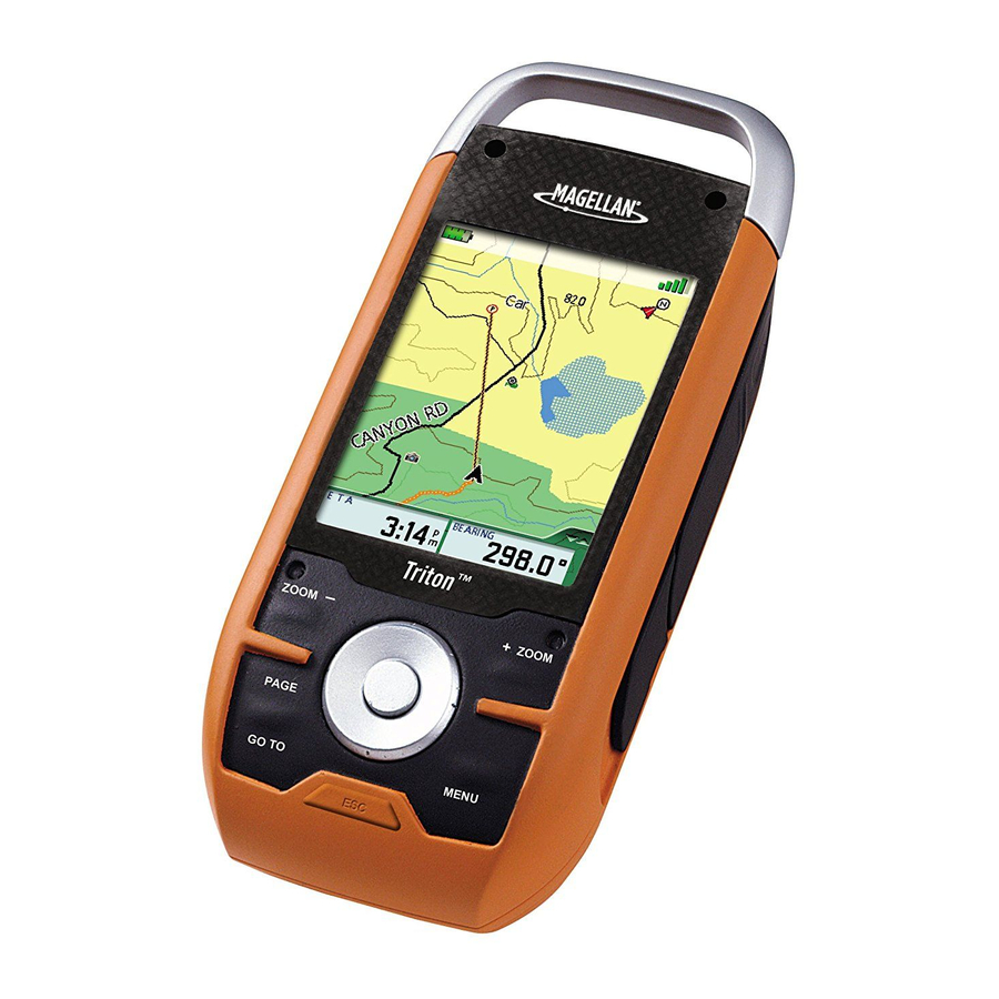
Map Screen Details

- Battery level indicator
- Destination icon.
- Route indicator.
- Present position cursor with direction of travel.
- Data Field 1. Customize to display data type selected.
- Data Field 2. Customize to display data type selected.
- Track.
- Navigational Fields access
- North indicator
- Satellite signal strength indicator
Satellite Signals

4 bars green: Strong signal
Blank: No satellite signals. Unable to compute position.
Use the Page button to step through the navigation screens until the Satellite Status screen is displayed. This screen provides a visual representation of the satellites and signal strength.

Tips on improving satellite signal strength

Go outdoors and hold the receiver with the antenna (top of the receiver) up so the GPS receiver has a clear view of the sky.
Move away from large structures or overhanging trees that may interfere with satellite reception.
If still not receiving strong satellite reception, try moving slightly to a new location.
This receiver may not be able to get satellite signals while indoors. If you are not getting strong satellite signals, go outside and follow the tips provided above.
Saving a Waypoint

Creating a GOTO Route

Main Menu
Go To

Waypoint
Select a waypoint to set a one-leg route to.
Place
Select a map object (cities, parks, etc.) from the basemap or from optional installed maps.
Trail
Follow a previously saved trail.
Geocache
Select a stored cache waypoint to set a one-leg route to.
Route
Choose a saved route to follow.
Create

Waypoint
Create a waypoint from the current location, a point on the map or enter coordinates.
Place
Not available.
Trail
Saving current breadcrumb track as a Trail.
Geocache
Create a cache waypoint from the current location, a point on the map or enter coordinates.
Route
Create a a multi-leg route that can be saved.
View

Maps
View infomation on the basemap or loaded detailed maps.
Local Info
View nearby places, weather, tides & currents, hunting & fishing times, and sunrise/sunset information.
Tracks
Select from Review History, Vertical Profile, Save Tracks, Erase Tracks or track Options.
Music & Photos
View stored photos, music and recordings.
Profiles
View hiking, marine and geocaching profiles.
Settings
View navigation settings, memory, connectivity, about, and perform diagnotics.
Navigation Settings

Units of Measure
Select kilometers, miles or nautical miles.
North Reference
Select Magnetic or True.
Coordinate System (Primary and Secondary)
Select from Lat/Lon or other coordinate systems listed.
Map Datum (Primary and Secondary)
Select the map datum to be used by the Triton to match any map datum used on paper charts.
Re-Initialize GPS
Initialize GPS to your present position for quicker first fix.

Documents / ResourcesDownload manual
Here you can download full pdf version of manual, it may contain additional safety instructions, warranty information, FCC rules, etc.
Download Magellan Triton 2000 - Gps Navigator Reference Card
Advertisement


Need help?
Do you have a question about the Triton 2000 and is the answer not in the manual?
Questions and answers