
Related Manuals for Magellan TR7


Summary of Contents for Magellan TR7
- Page 1 Magellan TR7 Trail and Street GPS Navigator User Manual TR7/TN7771SGLUC The Official GPS of M A G E L L A N G P S . C O M Jeep Jamboree USA...
- Page 2 An AC adapter and vehicle power adapter are included with your TR7. Use ONLY the car charger approved for/supplied with your TR7. Use of another type of car charger could result in fire or electric shock. For safety reasons, the battery in your TR7 will stop charging when the ambient temperature is less than 32°F (0°C) or more than 113°F (45°C).
-
Page 3: Table Of Contents
TR7 Hardware ................................6 TR7 Software ................................7 Getting Started ......................8 Language and Wi-Fi settings ............................8 Create Your TRX Account and Register Your TR7 ......................9 Update Software ................................10 Update Maps ................................. 11 Mount the TR7 in Your Vehicle ............................12 Power/Charging................................ - Page 4 Table of Contents. TRX Trailhead ......................33 Use TRX Trailhead ................................ 33 Sign In to TRX Trailhead ............................... 34 Wish List and Log ................................36 Search for Trails, Tracks, Trips, OHV Attractions, and POIs ..................38 Save To Your Wish List ..............................41 Report Issues ................................
-
Page 5: Tr7 Overview
The TR7 includes the largest database of off-road trails in the U.S., with over 100,000 preloaded OHV trails. The TR7 gives you access to a growing database of user-generated tracks, allowing you and thousands of other off-roaders to upload custom tracks, waypoints, detailed terrain info, and up-to-date trail conditions for the TRX community to see. -
Page 6: Tr7 Hardware
TR7 Hardware Speaker Power Button Reset Button AUX Out microSD Slot USB Power Input Your device requires additional power to function at optimal levels. For best performance, use the included power adapters, which are specially rated for your device. -
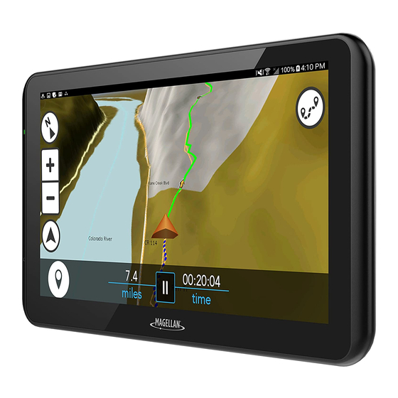
Page 7: Tr7 Software
TR7 Software Dashboard Screen 1. Map: Tap to open Map screen. 2. Dirt Miles traveled, Tracks recorded, and Achievements earned displayed here. 3. Journal: Contains track Log and Wish List of saved trails. 4. Search: Search for Trails, Tracks, POIs, etc. -
Page 8: Getting Started
Getting Started Account Creation & Registration. 1. Select Language. Set your device language to English or French > tap Next. 2. Read and Agree to End-User License Agreement (EULA). Read the EULA > tap I agree to continue or I disagree to delay setup. Note: You cannot proceed with setup until you’ve read and agreed to the EULA. -
Page 9: Create Your Trx Account And Register Your Tr7
You must create a TRX account to save data to your device or sync with TRX Trailhead. Not having a TRX account can result in lost data. IMPORTANT: If you already have a Magellan GPS email address and password, use those account credentials to create your TRX account. -
Page 10: Update Software
4. Wait a few minutes for the software update to finish installing > tap Open. 5. When you see a notification that says “Magellan TRX needs to download resources”, tap Start download Make sure Download over Wi-Fi only is checked. -
Page 11: Update Maps
Getting Started Account Creation & Registration. 6. Update Maps. Note: Make sure that you download the latest software version before downloading new map packages. Visit trxsupport.magellangps.com for a list of latest software versions. To update your maps: 1. On the Updates screen, tap Map Update. 2. -
Page 12: Mount The Tr7 In Your Vehicle
Getting Started Mount the Device. Attach your device to the included cradle and mount and use suction cup base to adhere your device to your vehicle’s windshield or dashboard. For best image quality, mount your device as follows: WARNING: Observe local laws and regulations regarding proper mounting of devices. Windshield Dashboard Tilt device up... -
Page 13: Power/Charging
Getting Started 1. Power On. Press and hold the Power button on the top of your device. Within seconds, you’ll see the Magellan logo, and your device will boot up. Press and hold. 2. Charge the Device. Using the included AC Adapter or Vehicle Power Adapter (VPA): 1. -
Page 14: Create Your Vehicle Profile
Getting Started Now that you’ve got the TR7 basics, customize your profile before you hit the trail. Create Your Vehicle Profile. Create a customized Vehicle Profile. You can create a separate vehicle profile for your OHV vehicles and tow rigs. -
Page 15: Link To Social Media
3. Enter account details > tap > tap to finish linking to Twitter. Link Your Instagram Account To link your TR7 to your Instagram account, tap next to the Instagram option and repeat the steps for linking your Twitter account. -
Page 16: Riding With Tr7
Using Street Navigation. You can route to any location on the map (trails, tracks, POIs, addresses, and more) on your TR7 without having to use another navigation device. To use street navigation on your TR7: 1. Tap Search from the TRX Dashboard. -
Page 17: Tracking
Riding with TR7 Tracking. To track your progress from any location: 1. Tap from the Dashboard to get to the Map screen. 2. Tap to start tracking > tap to pause tracking at any time. On the Active Map screen, you can: Mark a Quick Waypoint. -
Page 18: Change Map Options
• Tap Done to return to the Map screen. *You must have a DigitalGlobe subscription before you can access satellite imagery on your TR7. Satellite Imagery is intended to be downloaded before use on the trail. Downloading Satellite Imagery requires a strong and reliable WiFi connection to download large imagery files. -
Page 19: Mark Waypoints
Riding with TR7 Pausing the track displays more options. Detail Waypoint: Record an Audio Waypoint, select Waypoint type at Current Location, mark Point on Map, or Enter Waypoint using Coordinates. Social Post: Tweet Dirt Miles from your current track. (Requires Wi-Fi connection) Backtrack: Follow your track back to starting point. - Page 20 Riding with TR7 To save a Detail Waypoint: 1. Tap to pause your track > tap 2. Tap Detail Waypoint option. : Record custom audio message. 1. Tap > record your message. 2. Tap to save Audio Waypoint. : Select Waypoint for your location.
-
Page 21: Social Post
Riding with TR7 Social Post. Tweeting from your Track lets your friends and other off-roaders know where your location and how many Dirt Miles you’ve driven. To Tweet from your track: 1. Tap to pause your track > Tap 2. Tap... -
Page 22: Backtrack
Riding with TR7 Backtrack. Follow a track back to the starting point: 1. Tap . You’ll see this notification: 2. Tap to begin Backtracking, or to return to the Pause screen. While Backtracking, you’ll see guidance arrows moving to the start of your track. - Page 23 Riding with TR7 5. Tap a Terrain type. 6. Tap Terrain information. 7. Tap Pitch, Tilt, 1-5 Star Rating, and Difficulty Level. 8. Select a Dificulty Rank for the track Easy Intermediate Advanced Expert only 9. Tap Comment to include track details (conditions, weather, etc.).
-
Page 24: Use The Journal
Riding with TR7 Use The Journal. (accessible from TRX Dashboard) contains your saved items in two lists: : Contains your completed tracks in chronological order, with the most recent saved Track at the top. : Contains trails, tracks, and waypoints that you’ve saved from Search. -
Page 25: Delete A Trip
Riding with TR7 Delete A Trip 1. Tap > tap the check box next to each trip you want to delete > tap 2. Tap to delete the trip, or to return to your Log or Wish List. To navigate to a trail, POI, or other item that you’ve saved to your Wish List, tap an item on your Wish List >... -
Page 26: Exploring With Tr7
Exploring with TR7 Search For Map Content. to search through the TR7 Basemap of over 100,000 preloaded trails in addition to user tracks, POIs, OHV Attractions, and more. Search by keyword or manually enter search criteria in the Search Options menu (Nearby, Near City or ZIP, Near Point on Map, or Near Coordinates). - Page 27 Exploring with TR7 to populate the map with results related to your search. to refine results > choose a sorting option. again to refine your search results on the map. Tip: Searching by cities or regions (e.g. Moab, Rubicon) in the keyword search...
-
Page 28: View And Save Searched Items
Wish List. 3. Tap to confirm. Use Satellite Imagery. You have several options for saving satellite imagery to your TR7 so that you can access the satellite imagery associated with that map area even when you’re outside of network coverage. Notes •... -
Page 29: Purchase A Digitalglobe Subscription
Note: Your DigitalGlobe subscription may not appear in your account right away. Please allow 10-20 minutes before the subscription is activated on your devices. You may also need to restart your TR7 in order to refresh the software and begin... -
Page 30: Save Satellite Imagery From The Map Screen
Satellite imagery in the map area around the item will be available when you travel to that location using your TR7, even without network coverage. Note: Satellite imagery is saved to the TR7’s internal storage. To save space, delete all unused satellite map areas from your Saved Maps once you’ve finished using them. -
Page 31: Import Gpx Files
3. Eject microSD card from your computer and insert into the microSD card slot on the left side of your TR7. Make sure that you see a notification on the top right of the screen that says “SD card is mounted”. -
Page 32: Export Tracks As Gpx Files
Using GPX Files Export Tracks As GPX Files. You can export any track that you’ve recorded as a GPX file to be used on external devices. IMPORTANT: Make sure you insert a microSD card before exporting a track. Use a 32GB (or smaller) microSD formatted to FAT32 (or FAT16 if you’re using a 16GB card). -
Page 33: Trx Trailhead
TRX Trailhead Use TRX Trailhead TRX Trailhead allows you to instantly see all 100,000+ Trails in the TRX Basemap to quickly search for Trails for your Wish List. You can also edit/review Tracks in your Log, edit Waypoints, search for user Tracks, and publicly share your Tracks. Minimize Log/Wish List. -
Page 34: Sign In To Trx Trailhead
TRX Trailhead Sign In to TRX Trailhead 1. Go to www.TRXTrailhead.com. 2. Click 3. Enter your account details. 4. Click Note: Refer to Create Your Account on TRX Trailhead for information about registering on TRX Trailhead. If you forget your TRX account password, use TRX Trailhead to reset it: 1. - Page 35 TRX Trailhead Once you’ve logged in, you’ll see two tabs for your Wish List and Log. Tip: Click on the top right of the screen to: • View recently earned achievements. • View devices registered to your account. • View In-App Purchases. •...
-
Page 36: Wish List And Log
Access your Log and Wish List by clicking on the tabs on the left side of the screen. All items that you’ve saved to your Log and Wish List on your TR7 will appear here when you log into TRX Trailhead with your TRX account. - Page 37 TRX Trailhead Spokee Track Difficulty: Rating: (12) Elevation Terrain Spec Satellite View Map View Spokee Track 1,700 User Name Start Elevation: End Elevation: Source: All Trails Latitude: 42.655025 | Longitude: -86.201982 2000 Searched Trails Rating: Private Tracks 12.82 Dirt Miles: Difficulty: 1500 User Published Tracks...
-
Page 38: Search For Trails, Tracks, Trips, Ohv Attractions, And Pois
TRX Trailhead Search for Trails, Tracks, Trips, OHV Attractions, and POIs. To search for an item in TRX Trailhead: 1. Click an items from Search options at the top of the page. Leave all items unselected if you want to search for an address. Tip: Click on the user Tracks or Trips icons to filter your search results. - Page 39 TRX Trailhead Click on a Trail or POI for information. Note: Multiple Trails within a single route appear in a list form. Click any of the items in the list to view Trail information. WARNING: User-published tracks are labeled with the following warning: This is a publicly shared trail that has not been verified for safety.
- Page 40 TRX Trailhead Each trail and track is represented by a Marker Label as well as Attributes and Elevation details: Number of Dirt Miles Trail Name User Rating Content Type Save To Wish List Allowed Vehicle Types Difficulty Ranking Lat/Long Position # of Users Completed User Rating...
-
Page 41: Save To Your Wish List
Wish List: Tip: Any items you add to your Wish List on TRX Trailhead automatically sync with your TR7 Wish List next time you sign in or if you choose Settings > Manual Sync from your TR7. Report Issues To report issues with an item on the map: 1. -
Page 42: Create A Route
6. Click Save to add your custom route to your Wish List. Once your route is saved to your Wish List, go to your TR7 and tap Settings > Manual Sync to sync your new Route data to your TR7. -
Page 43: Connect To Social Media
TRX Trailhead Connect To Social Media Connect your Twitter and Instagram accounts to your TRX Trailhead account (if you haven’t already on your TR7 device). To connect to Twitter and Instagram: 1. Click at the top right corner of the screen. -
Page 44: Add A New Trip
2. Click and hold on the Marker Label > drag the Marker Label to the Trip folder and release your click. The item is added to the Trip. Repeat for each item you want in your Trip. You can see the Trip in your TR7 Log and once you’ve synced your account. -
Page 45: Trx Glossary
Elevation Profile: interactive box showing elevation gain/loss on a trail, measured by Start and End elevations (TRX Trailhead only). Filter (Search): used in Search to narrow down Trail, Trip, and POI results in the Basemap (TR7 and TRX Apps). Journal: contains a user’s Log and Wish List. - Page 46 Orientation: button that allows a user to toggle between North Up and Track Up views. This button turns blue and can be tapped to restore North Up orientation when a user has panned around the map (TR7 and TRX Apps).
-
Page 47: Warranty
PRODUCT. (b) In the event of a defect, Magellan will, at its discretion, repair or replace the hardware product with a product of like kind or quality, which may be new or reconditioned, with no charge to the purchaser for parts or labor. Magellan’s limit of liability under the limited warranty shall be the actual cash value of the product at the time the purchaser returns the product to Magellan for repair less a reasonable amount for usage, as determined by Magellan in its sole discretion. - Page 48 Examples of such conditions include but are not limited to changes in the GPS or GLONASS transmission.). The opening, dismantling or repairing of this product by anyone other than an authorized Magellan Service Center will void this warranty.
-
Page 49: Technical Support
Connect with us @MagellanTRX © 2017 MiTAC International Corporation. The Magellan logo and Magellan are registered trademarks of MiTAC International Corporation, and OneTouch is a trademark of MiTAC International Corporation and are used under license by MiTAC Digital Corporation. All rights reserved.
Need help?
Do you have a question about the TR7 and is the answer not in the manual?
Questions and answers
Does the database include all Hawaii islands , specifically , Kauai ?