Table of Contents
Advertisement
Quick Links
Advertisement
Table of Contents

Related Manuals for Advanced Navigation Boreas D90


Summary of Contents for Advanced Navigation Boreas D90
- Page 1 Boreas D90 Reference Manual v1.2 11 Oct 2022...
-
Page 2: Table Of Contents
Contents 1 Revision History 2 Introduction 2.1 Firmware Changelog 2.2 Hardware Changelog 3 Evaluation Kit 3.1 Evaluation Kit Contents 4 Getting Started 5 Part Numbers and Ordering 5.1 Evaluation Kit 5.2 Standalone Units 5.3 GNSS Receiver Licence Upgrades 5.4 Accessories 6 Specifications 6.1 Navigation Specifications 6.1.1 Dual Antenna Heading Accuracy... - Page 3 7.6 Power Supply 7.7 Electrical Domains 7.8 GNSS Antennas 7.8.1 Antenna Cables 7.8.2 Antenna Suction Cup Mount 7.8.3 Antcom Antenna Survey Mount Assembly 7.9 Networking 7.10 Odometer 7.10.1 Factory VSS Signal 7.10.2 OBDII Odometer Interface 7.10.3 Aftermarket Wheel Speed Sensor 7.10.4 Radar Speed Sensor 7.11 Magnetics 7.12 Vibration 8 Using Boreas...
- Page 4 8.16 Heave 8.17 Environmental Exposure 8.17.1 Temperature 8.17.2 Water 8.17.3 Salt 8.17.4 Dirt and Dust 8.17.5 pH Level 8.17.6 Shocks 8.17.7 Atmospheres 8.18 Upgrading the Boreas Firmware 9 Configuring and Monitoring Boreas 9.1 Using the Web User Interface 9.1.1 Main View 9.1.1.1 Status Indicator 9.1.1.2 Current Time, Position and Heading 9.1.1.3 Altitude Indicator...
- Page 5 9.1.3.10 Dual Antenna 9.1.3.11 Ethernet Settings 9.1.3.12 NTRIP Client 9.1.3.13 CAN Settings 9.1.3.14 Advanced 9.1.3.15 GNSS Configuration 9.1.4 Tools Menu 9.1.4.1 Firmware Update 9.1.4.2 Logs 9.1.4.3 Viewing Logged Data 9.2 Using Boreas Manager 9.2.1 Software Changelog 9.2.2 System Requirements 9.2.3 Installation and Starting 9.2.4 Troubleshooting 9.2.4.1 Windows 9.2.4.2 Linux...
- Page 6 10.1 Ethernet 10.1.1 Ethernet Modes 10.1.2 Ethernet Functions 10.1.2.1 NMEA Input 10.1.2.2 Novatel GNSS Input 10.1.2.3 Topcon GNSS Input 10.1.2.4 ANPP Input 10.1.2.5 RTCM Differential GNSS Corrections Input 10.1.2.6 Trimble GNSS Input 10.1.2.7 u-blox GNSS Input 10.1.2.8 Hemisphere GNSS Input 10.1.2.9 Teledyne DVL Input 10.1.2.10 Tritech USBL Input 10.1.2.11 Linkquest DVL Input...
- Page 7 10.6.1.42 ANPP Output 10.6.1.43 TSS1 Output 10.6.1.44 Simrad 1000 Output 10.6.1.45 Simrad 3000 Output 10.6.1.46 Serial Port Passthrough 10.6.1.47 GNSS Receiver Passthrough 11 Advanced Navigation Packet Protocol 11.1 About Packets 11.1.1 Packet Structure 11.1.1.1 Header LRC 11.1.1.2 Packet ID 11.1.1.3 Packet Length 11.1.1.4 CRC...
- Page 8 11.1.3 Packet Acknowledgement 11.1.4 Packet Rates 11.1.5 Packet Timing 11.2 Data Types 11.3 System Packets 11.3.1 Acknowledge Packet 11.3.1.1 Acknowledge Result 11.3.2 Request Packet 11.3.3 Boot Mode Packet 11.3.3.1 Boot Mode Types 11.3.4 Device Information Packet 11.3.4.1 Device ID 11.3.5 Restore Factory Settings Packet 11.3.6 Reset Packet 11.3.6.1 Verification Sequence Values 11.3.7 Serial Port Passthrough Packet...
- Page 9 11.4.14 UTM Position Packet 11.4.15 NED Velocity Packet 11.4.16 Body Velocity Packet 11.4.17 Acceleration Packet 11.4.18 Body Acceleration Packet 11.4.19 Euler Orientation Packet 11.4.20 Quaternion Orientation Packet 11.4.21 DCM Orientation Packet 11.4.22 Angular Velocity Packet 11.4.23 Angular Acceleration Packet 11.4.24 External Position and Velocity Packet 11.4.25 External Position Packet 11.4.26 External Velocity Packet 11.4.27 External Body Velocity Packet...
- Page 10 11.4.44 Gimbal State Packet 11.4.45 Automotive Packet 11.4.46 Basestation Packet 11.4.46.1 GNSS Fix Status 11.4.47 Zero Angular Velocity Packet 11.4.47.1 Zero Angular Velocity Duration 11.4.48 Extended Satellites Packet 11.4.48.1 11.4.48.2 Satellite Systems 11.4.48.3 Satellite Frequencies 11.4.48.4 Extended Satellites Flags 11.4.49 Sensor Temperature Packet 11.4.50 System Temperature Packet 11.5 Configuration Packets 11.5.1 Packet Timer Period Packet...
- Page 11 11.5.12.2 Trimble BD992 GNSS Receiver 11.5.12.3 GNSS Frequency Bitfields 11.5.12.4 L Band Modes 11.5.12.5 L Band Satellite IDs 11.5.13 User Data Packet 11.5.14 GPIO Input Configuration Packet 11.5.15 IP Dataports Configuration Packet 11.5.15.1 IP Dataport Mode 11.5.16 CAN Configuration Packet 11.5.16.1 CAN Protocol 12 Reference Information 12.1 Technology Overview 12.1.1 GNSS...
- Page 12 If any part of this document refers to any third party products or services it shall not be deemed a license grant by Advanced Navigation for the use of such third party products or services, or any intellectual property contained therein or considered as a warranty covering the use in any manner whatsoever of such third party products or services or any intellectual property contained therein.
-
Page 13: Revision History
Boreas Reference Manual • Revision History 1 Revision History Version Date Changes 11/10/2022 Updated firmware changelog, see 2.1 Firmware Changelog Updated hardware changelog, see 2.2 Hardware Changelog Updated software changelog, see 9.2 Using Boreas Manager Updated Logging information as per Manager v6.2, see 9.2.8.3 Log Converter Added a link to the product page to find the SDK, see... -
Page 14: Introduction
The system features ultra fast gyrocompassing heading that works under all conditions. Boreas is equipped with an Advanced Navigation Aries GNSS receiver as standard. A Trimble BD992 variant is also available. See 5 Part Numbers and Ordering for more information. -
Page 15: Firmware Changelog
Use the links below for detailed information about Boreas. 5 Part Numbers and Ordering 6 Specifications 7 Installing Boreas 8 Using Boreas 9 Configuring and Monitoring Boreas 10 Interfacing 11 Advanced Navigation Packet Protocol 2.1 Firmware Changelog Version Date Changes 18 August Added support for Trimble BD992 receiver 2022 Allowed firmware update using any ANPP dataport. -
Page 16: Evaluation Kit
Boreas Reference Manual • Boreas Evaluation Kit 3 Evaluation Kit The Evaluation Kit provides the necessary parts and accessories to set up and connect a Boreas unit. It is supplied in a rugged transport case to protect the equipment during transit. Figure 2: Boreas Evaluation Kit Transport Case v1.2 Page 4... -
Page 17: Evaluation Kit Contents
Boreas Reference Manual • Boreas Evaluation Kit 3.1 Evaluation Kit Contents Figure 3: Boreas Evaluation Kit Contents v1.2 Page 5 11 Oct 2022... - Page 18 Boreas Reference Manual • Boreas Evaluation Kit Part Number Quantity Description Notes BOREAS-D90 Boreas INS Unit Boreas unit in rugged enclosure with or BOREAS-D90- Aries Dual GNSS Receiver or Trimble BD992 BD992 GNSS Receiver VSP6337L VeroStar GNSS Antenna VeroStar GNSS Antenna - L1/L2/L5 plus L band, pole mount, TNC Female Connector BF046WS210224-...
-
Page 19: Getting Started
These instructions assume the use of components provided in the 3 Evaluation Kit, or purchased as Advanced Navigation supplied optional Accessories. 1. Plug the power supply into the power connector on the breakout cable and then into the wall socket. See 7.6 Power... -
Page 20: Part Numbers And Ordering
BOREAS-D90-EK Boreas D90 INS Evaluation Kit. Includes the items listed in 3.1 Evaluation Kit Contents BOREAS-D90-BD992-EK Boreas D90 BD992 Receiver Evaluation Kit. Includes the items listed in 3.1 Evaluation Kit Contents Table 5: Evaluation Kit Part Numbers 5.2 Standalone Units Part Number... -
Page 21: Gnss Receiver Licence Upgrades
Boreas Reference Manual • Part Numbers and Ordering 5.3 GNSS Receiver Licence Upgrades These licenses are only applicable to Boreas units with a Trimble BD992 GNSS Receiver. Part Num- Description Notes BD992- Upgrade Boreas BD992 to 10 cm RTK Applicable for Trimble BD992 GNSS Receiver LIC-10CM variant. -
Page 22: Accessories
Boreas Reference Manual • Part Numbers and Ordering 5.4 Accessories Part Number Description Notes CABLE-38999- Ethernet MIL-DTL-38999 3 m industrial Ethernet cable RJ45-3M Series III RJ45 to RJ45 3 MIL-DTL-38999 Series III RJF TV 6.5 Ethernet Connection CABLE-38999-19- Breakout cable for 2 m breakout cable for IO connection 32-BREAKOUT IO connection... -
Page 23: Specifications
Boreas Reference Manual • Specifications 6 Specifications Review the following specifications for Boreas: 6.1 Navigation Specifications 6.2 Hardware Specifications 6.3 Communication Specifications 6.4 Electrical Specifications 6.5 Ethernet Connection 6.6 IO Connection 6.1 Navigation Specifications Specification Horizontal Position Accuracy 1.2 m Vertical Position Accuracy 2.0 m Horizontal Position Accuracy (SBAS) -
Page 24: Dual Antenna Heading Accuracy
Bandwidth 300 Hz 400 Hz 50 Hz Table 11: Boreas D90 Sensor Specifications Note: Boreas sensors are calibrated for bias, sensitivity, misalignment, cross-axis sensitivity, non- linearity and gyroscope linear acceleration sensitivity across the full operating temperature range. v1.2 Page 12... -
Page 25: Gnss Specifications
Boreas Reference Manual • Specifications 6.1.3 GNSS Specifications Parameter Specification Aries Trimble BD992 GNSS Receiver Receiver Supported Navigation Systems GPS L1, L2 GPS L1, L2, L5 GLONASS L1, L2 GLONASS L1, L2 Galileo E1, E5b Galileo E1, E5b, E5a BeiDou B1, B2 BeiDou B1, B2, B3 Supported SBAS Systems WAAS... -
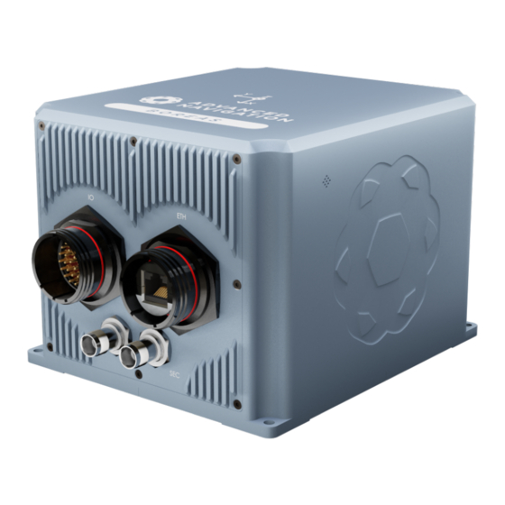
Page 26: Mechanical Drawings
Boreas Reference Manual • Specifications Specification Value Environmental Protection MIL-STD-810H IP67 Mean Time between Failure (MTBF) > 70,000 hours Shock Limit 50 g 11 ms Vibration Limit 8 g rms 20-2000 Hz random Dimensions (height x width x length) 160 mm x 140 mm x 115.5 mm Weight 2.5 kg Table 13: Hardware Specifications for Boreas... -
Page 27: Cable Bend Radius
Boreas Reference Manual • Specifications 6.2.1.1 Cable Bend Radius Figure 5: Recommended Minimum Bend Radius for Advanced Navigation Supplied Cables 6.2.2 Serial Number The device serial number can be inspected by using the Device Information page in the web interface (see... -
Page 28: Communication Specifications
Ethernet RS232/RS422 1PPS Speed 100 Mbit Ethernet 4800 to 4 M baud serial Protocols Advanced Navigation Packet Protocol, NMEA or CANopen Peripheral Interface 2 x GPIO 1 x 1PPS Output 1 x Auxiliary RS232 1 x Alarm Output GPIO Operating Voltage Levels 3.3 V... - Page 29 Boreas Reference Manual • Specifications Parameter Minimum Typical Maximum Rx Threshold High 1.5 V 2.0 V RS422 Tx Differential Output 1.5 V Tx Short Circuit Current ±250 mA Rx Differential Threshold -0.2 V -0.05 V GPIO when set to 5 V Output Voltage Low 0.3 V Output Voltage High...
-
Page 30: Ethernet Connection
Boreas Reference Manual • Specifications Table 15: Electrical Specifications 6.5 Ethernet Connection Advanced Navigation offers a 3 m industrial Ethernet cable with a MIL-DTL-38999 Series III connector to create a rugged connection to the unit. This is supplied as part of the 3 Evaluation Kit, and also a recommended accessory with the standalone unit. - Page 31 Boreas Reference Manual • Specifications Figure 8: IO Unterminated Cable Colour Function Black Power Ground Power Supply Orange 1PPS Blue GPIO1 Brown GPIO2 Violet RS422-TX(+)/RS232-TX PRI Yellow RS422-RX(+)/RS232-RX PRI White Serial Ground 1 Light Blue RS422-TX(+)/RS232-TX AUX Light Green RS422-RX(+)/RS232-RX AUX White/Red Stripe Serial Ground 3 Light Brown/Black Stripe...
-
Page 32: Io Breakout Cable
Orange/Black Stripe Table 17: Pin Allocation Table 6.6.2 IO Breakout Cable Advanced Navigation offers a 2 metre long pre-terminated IO cable that is supplied as part of the Boreas Evaluation Kit. Custom cable lengths are not available for pre-terminated cables. Figure 9: IO Breakout Cable... - Page 33 Boreas Reference Manual • Specifications Given below are details of the IO breakout cable connections. Function Primary Auxiliary GPIO 1PPS Alert Power Power Ground Ring Power Supply 1PPS GPIO1 GPIO2 RS422-TX (+)/RS232-TX PRI RS422-RX (+)/RS232-RX PRI Serial Ground 1 RS422-TX (+)/RS232-TX RS422-RX (+)/RS232-RX...
-
Page 34: Custom Io Termination
Table 18: IO Breakout Cable Connector Pin-out 6.6.3 Custom IO Termination Whilst it is recommended to use either a breakout cable or an unterminated cable from Advanced Navigation, you can also source and build your own custom IO cable. A suitable IO MIL-DTL-38999 Series III connector is available from several manufacturers with a variety of different cable boot and strain relief options. -
Page 35: Installing Boreas
Boreas Reference Manual • Installing Boreas 7 Installing Boreas To install and quickly get started with Boreas, follow the instructions provided in 7.1 Installation Checklist Additional information related to installing Boreas is provided in the following sections: 7.2 Mounting Boreas Guidelines for selecting the mounting location for the unit. -
Page 36: Mounting Boreas
Install the 64-bit version of Java 8 from http://www.java.com. iii. Download Boreas Manager from the Boreas product page of the Advanced Navigation website. Note: Boreas Manager is only available for systems with x64 architecture Double click Boreas Manager to start the application. No installation is required. - Page 37 Boreas Reference Manual • Installing Boreas Mount the unit within several metres of the GNSS antennas where possible. Mount close to the centre of gravity of the vehicle where possible. Mount the unit at least 10 cm away (and preferably as far as possible) from sources of dynamic magnetic interference such as high current wiring or large motors for best performance.
-
Page 38: Mounting Alignment
Boreas Reference Manual • Installing Boreas Figure 11: Boreas Mounting Holes and Alignment Pins It is recommended that M4 stainless steel washers with an outside diameter of 9 mm are used under the bolts. Blue loctite can also be used to prevent the screws from loosening over time. To ensure precision mounting repeatability, 1. -
Page 39: Cable Bend Radius
During installation, be mindful that cables must not be flexed beyond their specified bending radius. For Advanced Navigation supplied cables, these specifications can be found in 6.2.1.1 Cable Bend Radius. A figure of the bend radius for Advanced Navigation supplied cables is shown below. v1.2 Page 27 11 Oct 2022... -
Page 40: Mil-Dtl-38999 Series Iii Connector Mating
Boreas Reference Manual • Installing Boreas Figure 13: Bend Radius Using Advanced Navigation Supplied Cables For space-constrained applications, it may be necessary to use single-insulated wires with a customer-supplied plug. 7.8 GNSS Antennas for information about the bend radius of antenna cables. -
Page 41: Power Supply
The connector should be mated using its correct keying position and orientation. The screw thread should be tightened to fully mated position. If using an Advanced Navigation supplied cable, a visible red band indicates that the connector is not mated correctly. See 8.17 Environmental Exposure... - Page 42 Boreas Reference Manual • Installing Boreas Note: The Z axis is positive downwards, mounting the antenna above the Boreas unit will require a negative Z offset. It is very important to set this antenna offset accurately as Boreas corrects for lever arm velocities.
- Page 43 Boreas Reference Manual • Installing Boreas Figure 17: Antenna Offset Front View The secondary antenna should be mounted behind the primary antenna with as much separation as possible, and in line with the long axis of the vehicle, in the direction of travel, with as much separation as practically possible.
- Page 44 Boreas Reference Manual • Installing Boreas v1.2 Page 32 11 Oct 2022...
-
Page 45: Antenna Cables
It is very important not to bend the antenna cable tighter than its minimum bend radius, or to allow it to be dented. It is recommended to use wide cable ties, loosely fixed in order to avoid damaging the insulation or shielding. The cables should not be coiled. Advanced Navigation recommends: Keeping the antenna cables the same length, and as short as possible. -
Page 46: Antcom Antenna Survey Mount Assembly
Boreas Reference Manual • Installing Boreas 7.8.3 Antcom Antenna Survey Mount Assembly If using the optional Antcom G5ANT-53A4T1 antenna, mount it to a panel or mount to a standard 5/8”-11 survey mount with the included survey mount kit. See the figure below for assembly of each antenna with the survey mount kit. -
Page 47: Obdii Odometer Interface
7.10.3 Aftermarket Wheel Speed Sensor Applications requiring very high performance without GNSS for any length of time are recommended to use a high precision aftermarket wheel speed sensor. Advanced Navigation recommends aftermarket wheel speed sensors from Kistler, Pegasem or GMH Engineering. -
Page 48: Radar Speed Sensor
7.10.4 Radar Speed Sensor For applications requiring high performance in harsh conditions where aftermarket wheel speed sensors are not feasible, a radar speed sensor is recommended. Advanced Navigation recommends radar speed sensors from Stalker or GMH Engineering. Figure 22: Radar Speed Sensor v1.2... -
Page 49: Magnetics
Boreas Reference Manual • Installing Boreas 7.11 Magnetics Boreas uses FOG sensors to calculate heading; therefore, its heading is not corrupted by stray and changing magnetic fields. However, FOG sensors can still be affected by magnetic fields, which are strong and in close proximity. -
Page 50: Using Boreas
Boreas Reference Manual • Using Boreas 8 Using Boreas This section covers the following topics: 8.1 Filter Initialisation 8.2 Hot Start 8.3 Time 8.4 Heading Sources 8.5 Data Anti-aliasing 8.6 Vehicle Profiles 8.7 Atmospheric Altitude 8.8 Odometer Pulse Length 8.9 Reversing Detection 8.10 Motion Analysis 8.11 RTK 8.12 Raw Satellite Data... -
Page 51: Orientation Initialisation
Boreas Reference Manual • Using Boreas Figure 23: Initialisation Levels After all four levels of initialisation, the Boreas INS filter takes several minutes to achieve its full accuracy. It is recommended to wait two minutes after initialisation for applications requiring high accuracy. 8.1.1 Orientation Initialisation Orientation initialisation occurs automatically upon power on and typically completes within seconds. -
Page 52: Time Initialisation
When the GNSS fix is lost, the Boreas time will slowly lose accuracy at a rate of approximately 3 microseconds per hour. If greater accuracy is required for your application, Advanced Navigation may be able to offer Boreas with a temperature compensated disciplined oscillator that has greater time accuracy than 20 nanoseconds and less than 3 μs/hr of drift. -
Page 53: Heading Sources
Boreas Reference Manual • Using Boreas 8.4 Heading Sources There are several different heading sources available for Boreas. The heading sources can be configured using the Filter Options page in the Web UI (see 9.1 Using the Web User Interface) or in the Manager application (see 9.2 Using Boreas Manager ). -
Page 54: Data Anti-Aliasing
Boreas Reference Manual • Using Boreas 8.5 Data Anti-aliasing Internally the Boreas filters update at 1000 Hz. When Boreas outputs data, most applications require the data at a much lower rate (typically < 100 Hz). This causes a problem for time-based data such as velocities and accelerations where aliasing will occur at the lower rate. -
Page 55: Reversing Detection
Boreas Reference Manual • Using Boreas Note: To enter the pulse length manually, use the Odometer page in the Configuration menu in the Boreas Manager. 8.9 Reversing Detection Reversing detection is an algorithm that can detect when the vehicle is travelling backwards. Knowledge of reverse motion is important when using velocity heading or odometer input to provide correct results. -
Page 56: Radio Modem Rtk Corrections
The base station should be located no more than 50 km from the Boreas, and ideally closer. Advanced Navigation recommends contacting a local surveying company for assistance setting up a base station. -
Page 57: Kinematica Post Processing
Figure 26: Enabling Packet 60 8.13 Kinematica Post Processing Boreas can be used with Advanced Navigation’s post-processing platform Kinematica to achieve high-accuracy positioning of as low as 10 mm and significantly improved dead reckoning performance. You need to record a ANPP-format log file with certain packets enabled. -
Page 58: Heave
Boreas Reference Manual • Using Boreas specific source. FDE uses a minimum of six satellites to detect and exclude a possible faulty satellite from the navigation solution to ensure that the navigation function remains uninterrupted. The availability of RAIM and FDE might be slightly lower for mid-latitude operations and slightly higher for equatorial and high-latitude regions because of the nature of the orbits. -
Page 59: Dirt And Dust
Check Boreas product page of the Advanced Navigation website periodically for updates. Follow these steps: 1. Navigate to the Firmware Update page under the Tools menu. -
Page 60: Configuring And Monitoring Boreas
Boreas Manager, accessed on a computer via a serial adaptor Note: Boreas Manager is only available for systems with x64 architecture. Android App the Advanced Navigation Packet Protocol (9.4 Using ANPP) The Boreas Web UI is the recommended interface to configure as it is designed to be simple and easy to use without any software or system requirements. -
Page 61: Main View
Boreas Reference Manual • Configuring and Monitoring Boreas 9.1.1 Main View The Main View is accessible from other pages via the Map menu item under the View menu. Figure 27: Boreas Web UI Home Page 9.1.1.1 Status Indicator The Status Indicator section contains the current Boreas status, the GNSS fix type indicator, and the heading status. -
Page 62: Current Time, Position And Heading
Boreas Reference Manual • Configuring and Monitoring Boreas 9.1.1.2 Current Time, Position and Heading This section displays the current UTC time, position, and heading. The data will only be valid if Boreas has a HEALTHY status, there is a 3D GNSS fix or better, and the Heading is initialised. 9.1.1.3 Altitude Indicator The Attitude Indicator visualises roll and pitch using a standard artificial horizon. -
Page 63: Subcomponent Information
Boreas Reference Manual • Configuring and Monitoring Boreas Figure 28: Boreas Web UI Device Information Page 9.1.2.3 Subcomponent Information The Subcomponent Information page shows the serial numbers and hardware version information for the Boreas subcomponents. This will be useful information to include when contacting our support team. 9.1.2.4 Status The Status page shows the current status of Boreas as reported by the System State packet (ID #20) and Raw GNSS Packet (ID #29), detailed in sections... -
Page 64: Satellites
Boreas Reference Manual • Configuring and Monitoring Boreas Figure 29: Boreas Web UI Status Page 9.1.2.5 Satellites The Satellites page shows detailed information on the satellites that are visible to both antennas of the Boreas GNSS receiver. The information is displayed as a satellite skyplot, a table and an SNR graph. A maximum of 28 satellites will be displayed, even if more are accessible. -
Page 65: Raw Sensors
Boreas Reference Manual • Configuring and Monitoring Boreas Figure 30: Boreas Web UI Satellites Page 9.1.2.6 Raw Sensors The Raw Sensors page shows the temperature-calibrated raw IMU sensor values. In the lower plot only the air pressure is plotted. The current value from the internal temperature sensors are given on the right. -
Page 66: Orientation
Boreas Reference Manual • Configuring and Monitoring Boreas Figure 31: Web UI Raw Sensors Page 9.1.2.7 Orientation The Orientation page shows the Boreas orientation and angular velocity. Course is determined by measuring sequential positions. Slip is the difference between the heading and the course. v1.2 Page 54 11 Oct 2022... -
Page 67: Position
Boreas Reference Manual • Configuring and Monitoring Boreas Figure 32: Boreas Web UI Orientation Page 9.1.2.8 Position The Position page shows the Boreas position and position standard deviation. Latitude and longitude are converted to North and East metres from a reference point that can be reset by refreshing the web page in your browser. -
Page 68: Velocity And Acceleration
Boreas Reference Manual • Configuring and Monitoring Boreas Figure 33: Boreas Web UI Position Page 9.1.2.9 Velocity and Acceleration The Velocity and Acceleration page shows the Boreas velocity, acceleration and g-force. v1.2 Page 56 11 Oct 2022... -
Page 69: Gnss Receiver Information
Boreas Reference Manual • Configuring and Monitoring Boreas Figure 34: Boreas Web UI Velocity and Acceleration Page 9.1.2.10 GNSS Receiver Information This page shows information about the GNSS receiver fitted to Boreas. Figure 35: Boreas Web UI GNSS Receiver Information Page 9.1.2.11 Heave This page displays the heave at up to 4 reference points. -
Page 70: Coarse Heading Alignment
Boreas Reference Manual • Configuring and Monitoring Boreas Figure 36: Boreas Web UI Heave Page 9.1.2.12 Coarse Heading Alignment Coarse Alignment is used to derive the heading based on a gyrocompass' estimation of true North. For more information, see 8.4 Heading Sources. -
Page 71: Configuration Menu
Boreas Reference Manual • Configuring and Monitoring Boreas Warning Messages Description Initialisation restarted - change Initialisation has been automatically restarted due to a significant change in latitude detected in latitude. Initialisation restarted - Change Initialisation has been automatically restarted due to a change in the in COG lever arm detected Centre of Gravity (COG) lever arm configuration. -
Page 72: Alignment
Boreas Reference Manual • Configuring and Monitoring Boreas Other data formats available include NMEA0183, GNSS, TSS1, SIMRAD and other formats. For more information see 10.1.2 Ethernet Functions 10.2 Serial Interface. Figure 38: Boreas Web UI Data Ports Page 9.1.3.3 Alignment The Alignment page is used to set the alignment offsets of the system installation. -
Page 73: Baud Rates
Boreas Reference Manual • Configuring and Monitoring Boreas Figure 39: Boreas Web UI Alignment Page Alignment Offset If Boreas is installed into the vehicle with the positive X axis pointing forwards and the positive Z axis pointing down, then no alignment offset is required and the roll, pitch and heading offset values can remain at the factory defaults of zero. -
Page 74: Gpio
Boreas Reference Manual • Configuring and Monitoring Boreas Figure 40: Boreas Web UI Baud Rates Page 9.1.3.5 GPIO This page allows the user to select the input and output functions of the GPIO and Auxiliary ports. These functions are described in detail in 10.6.1 Dynamic Pin Functions. -
Page 75: Reset
Boreas Reference Manual • Configuring and Monitoring Boreas Figure 42: Boreas Web UI Odometer Configuration Page 9.1.3.7 Reset The Reset button causes the system to perform a power cycle. No configuration settings or state data are lost. The Cold Start button clears all filters, and connections are reset and must re-established. No configuration settings are lost. -
Page 76: Manual Initialisation
Boreas Reference Manual • Configuring and Monitoring Boreas Figure 44: Boreas Web UI Reference Point Offsets Dialogue 9.1.3.9 Manual Initialisation This page can be used to manually initialise Boreas when a GNSS fix is not available. Setting the position will initialise the navigation filter. -
Page 77: Ethernet Settings
Boreas Reference Manual • Configuring and Monitoring Boreas When using an automatic offset, the manual offset values are ignored. When using a manual offset, the automatic offset selection is ignored. When using automatic offset, the manual offset values will show the distance that Boreas has automatically measured. - Page 78 Boreas Reference Manual • Configuring and Monitoring Boreas 1. Select Enabled. 2. For Host/Server, enter the NTRIP Caster address. 3. For Port, enter the NTRIP Caster port numbe. This is usually 2101. 4. Click Save. 5. Click Get Mountpoints. 6. Select your mountpoint from the Mountpoint drop down list, being mindful that the distance should not exceed 50km.
-
Page 79: Can Settings
Boreas Reference Manual • Configuring and Monitoring Boreas Figure 48: Boreas Web UI NTRIP Client Page 9.1.3.13 CAN Settings The CAN Settings page allows you to enable or disable the CAN functionality. If you are only connecting to Boreas via the primary port then these settings can be ignored. The default for CAN is Enabled at 1,000,000 baud rate. -
Page 80: Advanced
Boreas Reference Manual • Configuring and Monitoring Boreas 9.1.3.14 Advanced The Advanced page allows you to set the voltage level of the GPIO and 1PPS signals lines along with the packet rates. The options are 5 V, 3.3 V, or Disabled. The default is 5 V. Note: The dedicated 1PPS signal is active whenever the voltage is set to 5 V or 3.3 V, and is therefore active by default. - Page 81 Boreas Reference Manual • Configuring and Monitoring Boreas Figure 51: Boreas Web UI Aries GNSS Configuration Page The table below lists the supported constellations and the corresponding GNSS sample period depending upon the number of constellations selected. When setting the 9.1.3.2 Data Ports, the packet rate of the 11.4.10 Raw GNSS Packet 11.4.37 Raw Satellite Data Packet...
-
Page 82: Tools Menu
Figure 52: Boreas Web UI BD992 GNSS Configuration Page 9.1.4 Tools Menu The Tools menu contains tools for performing certain procedures with Boreas. 9.1.4.1 Firmware Update This page is used to update the Boreas device firmware, Advanced Navigation device firmware files have the extension .anfw. v1.2 Page 70... -
Page 83: Logs
Check Boreas product page of the Advanced Navigation website periodically for updates. Follow these steps: 1. Navigate to the Firmware Update page under the Tools menu. -
Page 84: Viewing Logged Data
NMEA0183 log files are ASCII text and can be opened in any text editor. 9.2 Using Boreas Manager Boreas Manager is a software tool provided by Advanced Navigation for logging, testing, display and configuration of Boreas. It is designed to be simple and easy to use. It should run on most Windows, MacOS and Linux computers. -
Page 85: Software Changelog
Boreas Reference Manual • Configuring and Monitoring Boreas Figure 54: Screenshot of Boreas Manager 9.2.1 Software Changelog Version Date Changes 10 October Heading indicator is on after a successful North-Seeking operation 2022 Added Moving Base output to GPIO configuration Fixed Packet Rates not being refreshed after a save Removed unavailable GPIO options Corrected status indicator message in case of a logging error Fixed configuration import via network... -
Page 86: System Requirements
Boreas Reference Manual • Configuring and Monitoring Boreas Version Date Changes Receiver Information dialog boxes. Clicking on the field will copy to the clipboard Renamed position error to position standard deviation in position page of view menu Renamed Log Conversion menu item Added Settings menu item Various bug fixes 18 Febru-... - Page 87 Boreas Reference Manual • Configuring and Monitoring Boreas fixed this problem in over 15 years, so it probably won't be fixed. If you experience this problem, often a restart will resolve Otherwise there tool available http://www.stentec.com/anonftp/pub/wingps/pnpblockersetup.exe that can fix the issue. If the serial port does not show up when you plug in the FTDI USB to RS232/RS422 adaptor cable, you may need to install the drivers from www.ftdichip.com/Drivers/VCP.htm.
-
Page 88: Linux
Boreas Reference Manual • Configuring and Monitoring Boreas Figure 56: Setting the Windows Port Latency Value - 2 Figure 57: Setting the Windows Port Latency Value - 3 9.2.4.2 Linux If serial ports do not show up, the typical reason is a lack of permissions. The user should add themselves to the dialout group with the command: sudo adduser username dialout Compiz causes issues with the 3D mapping. -
Page 89: Main View
Boreas Reference Manual • Configuring and Monitoring Boreas Modemmanager can also sometimes cause problems on Linux installations. If you are not using a modem, it is recommended to remove modemmanager with the command: sudo apt-get remove modemmanager 9.2.5 Main View Figure 58: Boreas Manager Main View 9.2.5.1 Serial Port The Serial Port dialogue is used to connect to Boreas. -
Page 90: Connect / Disconnect
Boreas Reference Manual • Configuring and Monitoring Boreas 9.2.5.3 Connect / Disconnect This button allows the serial connection to be enabled or disabled. 9.2.5.4 3D Map The 3D map shows the Boreas position on the Earth as well as a red trail of position history. When the filter initialises the map will automatically reset the view to the Boreas position. - Page 91 Boreas Reference Manual • Configuring and Monitoring Boreas Figure 61: Boreas Manager Alignment Dialogue Alignment Offset If Boreas is installed into the vehicle with the positive X axis pointing forwards and the positive Z axis pointing down, then no alignment offset is required and the roll, pitch and heading offset values can remain at the factory defaults of zero.
-
Page 92: Port Mode And Baud Rates
Boreas Reference Manual • Configuring and Monitoring Boreas GNSS Antenna Offset The GNSS antenna offset is measured from the centre of the Boreas unit to the centre of the antenna in the body co-ordinate frame (X positive forward, Z positive down). Odometer Offset The odometer offset is measured from the centre of the Boreas unit to the point at which the vehicle's tyre being measured makes contact with the road in the body co-ordinate frame (X positive forward, Z positive down). -
Page 93: Odometer
Boreas Reference Manual • Configuring and Monitoring Boreas Figure 63: Boreas Manager GPIO configuration Dialogue 9.2.7.5 Odometer The Odometer dialogue allows the user to configure the odometer pulse length and view the real time odometer data to verify correct operation. Figure 64: Boreas Manager Odometer Dialogue 9.2.7.6 GPIO Output The GPIO output configuration dialogue allows the user to configure the output rates for the GPIO and Auxiliary... -
Page 94: Gimbal
Boreas Reference Manual • Configuring and Monitoring Boreas Figure 65: Boreas Manager GPIO Output Dialogue 9.2.7.7 Gimbal The Gimbal configuration dialogue is only used in speciality gimbal applications. Contact Support for more information on using Boreas inside a gimbal. v1.2 Page 82 11 Oct 2022... -
Page 95: Tools Menu
Boreas Reference Manual • Configuring and Monitoring Boreas Figure 66: Boreas Manager Gimbal Dialogue 9.2.8 Tools Menu The Tools menu contains tools for performing certain procedures with Boreas. Figure 67: Boreas Manager Tools Menu 9.2.8.1 Device Discovery Device discovery allows network discovery and reconfiguration of devices on the local network regardless of network settings. -
Page 96: Firmware Update
Once discovered devices on uncontactable network addresses can be reset to DHCP by pressing the “Set to DHCP” button for that device. 9.2.8.2 Firmware Update This page is used to update the Boreas device firmware, Advanced Navigation device firmware files have the extension .anfw. Figure 69: Boreas Manager Firmware Update Page Boreas contains firmware which is regularly updated to improve performance and add features. -
Page 97: Log Converter
Boreas Reference Manual • Configuring and Monitoring Boreas 1. Navigate to the Firmware Update page under the Tools menu. 2. Click Choose File and select the firmware file. 3. Click Upload File. 4. Wait for the system to restart. 9.2.8.3 Log Converter This tool allows the user to convert Boreas log files into various standard formats that are readable by many programs. -
Page 98: Network Connect
Boreas Reference Manual • Configuring and Monitoring Boreas Figure 72: Boreas Manager NTRIP Client Dialogue Note: These settings refer to the NTRIP Client built into the Boreas Manager application. It is not possible to configure the NTRIP Client built into Boreas using Boreas Manager. You need to use the web UI for this. -
Page 99: Logging
You will require a Serial to Bluetooth adaptor with Bluetooth v2.0 support connected to the primary serial port. The app can be found by searching the Google Play store for "Advanced Navigation Spatial Manager". Refer to the in-app Quick Start guide for more information. Contact... -
Page 100: Interfacing
Boreas Reference Manual • Interfacing 10 Interfacing Communication with Boreas is possible on the following ports: Ethernet 10.2 Serial Interface 1PPS Signal 10.6 GPIO Pins and the Auxiliary Port Each port has different input and output capabilities. 10.1 Ethernet The Ethernet interface offers a 100 MBit port for connection to a network, router or laptop/computer. The interface offers a UI, as well as 4 (four) configurable data ports. -
Page 101: Ethernet Functions
Boreas Reference Manual • Interfacing 10.1.2 Ethernet Functions Function Type Name Ethernet Input 10.1.2.1 NMEA Input 10.1.2.19 GNSS Receiver Passthrough 10.1.2.2 Novatel GNSS Input 10.1.2.3 Topcon GNSS Input 10.1.2.4 ANPP Input 10.1.2.5 RTCM Differential GNSS Corrections Input 10.1.2.6 Trimble GNSS Input 10.1.2.7 u-blox GNSS Input 10.1.2.8 Hemisphere GNSS Input 10.1.2.9 Teledyne DVL Input... -
Page 102: Nmea Input
Boreas Reference Manual • Interfacing 10.1.2.1 NMEA Input This function accepts external data in the NMEA 0183 format. Advanced Navigation Description recommends against using NMEA 0183 input wherever possible due to the inefficiency, low accuracy and precision and weak error checking of the format. All NMEA messages received must have a valid checksum. -
Page 103: Anpp Input
Boreas Reference Manual • Interfacing 10.1.2.4 ANPP Input This function accepts data in the ANPP format as specified in 11 Advanced Navigation Description Packet Protocol. 10.1.2.5 RTCM Differential GNSS Corrections Input This function accepts RTCM v3 GNSS corrections messages. This allows for Differential Description GNSS or RTK with the Boreas internal GNSS receiver. -
Page 104: Nmea Output
0513,12.5,W,E*02 $GPHDT,89.2,T*06 $PASHR,031644.460,089.19,T,-00.01,-00.47,-00.00,,,,0,0*2E 10.1.2.14 ANPP Output This function outputs data in the ANPP format as specified in 11 Advanced Navigation Description Packet Protocol. This function is for ANPP peripheral devices only. 10.1.2.15 TSS1 Output This function outputs the TSS1 format at a user configurable rate of up to 50 Hz. The Description output rate can be configured using the page in the web UI. -
Page 105: Serial Interface
The Support team can provide a baud rate calculator if it is required. For more information, contact Support at support@advancednavigation.com. 10.2.2 Format The format is fixed at 1 start bit, 8 data bits, 1 stop bit and no parity. See 11 Advanced Navigation Packet Protocol for details on the ANPP protocol. 10.3 1PPS Signal There is a dedicated 1PPS signal available on the 6.6 IO... -
Page 106: External Data
Boreas Reference Manual • Interfacing 10.5 External Data External sources of position, velocity and/or heading can be integrated into the Boreas filter solution. The data can be sent to Boreas in the ANPP format over the primary (RS232 or RS422), auxiliary (RS232 or RS422) or GPIO ports (RS232 only) or in a number of different formats. -
Page 107: Dynamic Pin Functions
Boreas Reference Manual • Interfacing 10.6.1 Dynamic Pin Functions v1.2 Page 95 11 Oct 2022... - Page 108 Boreas Reference Manual • Interfacing Function Type Name Tristate 10.6.1.1 Inactive Digital Output 10.6.1.2 1PPS Output 10.6.1.3 GNSS Fix Output Digital Input 10.6.1.4 Zero Velocity Input 10.6.1.5 Disable GNSS 10.6.1.6 Disable Pressure 10.6.1.7 Set Zero Orientation Alignment 10.6.1.8 System State Packet Trigger 10.6.1.9 Raw Sensors Packet Trigger 10.6.1.10 1PPS Input 10.6.1.11 Event 1 Input...
-
Page 109: Inactive
Boreas Reference Manual • Interfacing Function Type Name Serial Receive 10.6.1.28 NMEA Input 10.6.1.29 Novatel GNSS Input 10.6.1.30 Topcon GNSS Input 10.6.1.31 ANPP Input 10.6.1.32 RTCM Differential GNSS Corrections Input 10.6.1.33 Trimble GNSS Input 10.6.1.34 u-blox GNSS Input 10.6.1.35 Hemisphere GNSS Input 10.6.1.36 Teledyne DVL Input 10.6.1.37 Tritech USBL Input 10.6.1.38 Linkquest DVL Input... -
Page 110: Gnss Fix Output
Boreas Reference Manual • Interfacing 1PPS Source Voltage Level Trigger Auxiliary -5V to 5V Falling Edge GPIO 0V to 5V Rising Edge Figure 76: 1PPS Specifications The pin is normally low and pulses high for 50 milliseconds to signal the precise second. The 1PPS line starts pulsing approximately 100 milliseconds after power up and always fires irrespective of whether Boreas has accurate time or not. -
Page 111: Set Zero Orientation Alignment
Boreas Reference Manual • Interfacing GPIO Port 1, 2 Auxiliary Receive This function accepts a digital input with a low state enabling the atmospheric pressure Description sensor and a high state disabling the atmospheric pressure sensor. 10.6.1.7 Set Zero Orientation Alignment Type Digital Input GPIO Port... -
Page 112: Event 1 Input
This function is designed to allow external events to be recorded by Boreas. The event is Description recorded in the Filter Status (see 11 Advanced Navigation Packet Protocol ), and resets after the next packet is output. The event triggers on a transition from low to high. -
Page 113: Reverse Alignment, Forward High
If the pulse length is more than 0.1 metres then this odometer input function should be used. If it is less than 0.1 metres, the wheel speed sensor function should be used. Contact Advanced Navigation support for help integrating with your speed sensor. -
Page 114: Pressure Depth Transducer (Deprecated)
Boreas Reference Manual • Interfacing 10.6.1.20 Pressure Depth Transducer (deprecated) Type Frequency Input GPIO Port 1, 2 Auxiliary Receive This function is designed for interfacing with a legacy pressure depth transducer. These Description are no longer available and the function is now deprecated. 10.6.1.21 Left Wheel Speed Sensor Type Frequency Input... -
Page 115: Wheel Encoder Phase B
GPIO Port Auxiliary Receive This function accepts external data in the NMEA 0183 format. Advanced Navigation Description recommends against using NMEA 0183 input wherever possible due to the inefficiency, low accuracy and precision and weak error checking of the format. All NMEA messages received must have a valid checksum. -
Page 116: Novatel Gnss Input
Boreas Reference Manual • Interfacing Message ID Description GPGGA GNGGA 3D position GPGLL GNGLL 2D position GPRMC GNRMC 2D position, 2D velocity and coarse time GPVTG GNVTG 2D velocity GPHDT GNHDT HEHDT Heading GPGSV GNGSV Satellites GPGSA GNGSA Dilution of Precision GPZDA GNZDA Time xxPIPS... -
Page 117: Rtcm Differential Gnss Corrections Input
Boreas Reference Manual • Interfacing Auxiliary Receive This function accepts data in the ANPP format as specified in 11 Advanced Navigation Description Packet Protocol. When this function is enabled, the GPIO and auxiliary ports function the same as the primary port, with one exception: 1. -
Page 118: Teledyne Dvl Input
Boreas Reference Manual • Interfacing transmission of heading information. 10.6.1.36 Teledyne DVL Input Type Serial Receive GPIO Port Auxiliary Receive This function accepts DVL data from a Teledyne DVL. For assistance with configuration, Description contact support@advancednavigation.com. 10.6.1.37 Tritech USBL Input Type Serial Receive GPIO Port... -
Page 119: Nmea Output
GPIO Port Auxiliary Transmit This function outputs data in the ANPP format as specified in 11 Advanced Navigation Description Packet Protocol. This function is for ANPP peripheral devices only. When this function is enabled, the GPIO and auxiliary ports function the same as the primary port, with one exception: 1. -
Page 120: Simrad 3000 Output
Boreas Reference Manual • Interfacing GPIO Port Auxiliary Transmit This function outputs the Simrad 1000 format at a user configurable rate of up to 50 Hz. Description The output rate can be configured using the page in the 9.1 Using the Web User Interface. -
Page 121: Advanced Navigation Packet Protocol
It has a well defined specification and is very flexible. It is used across all Advanced Navigation products. A packet type can be identified by its unique Packet ID. For more information about packets, see 11.1... - Page 122 Boreas Reference Manual • Advanced Navigation Packet Protocol Packet ID Name Length 11.4.13 ECEF Position Packet 11.4.14 UTM Position Packet 11.4.15 NED Velocity Packet 11.4.16 Body Velocity Packet 11.4.17 Acceleration Packet 11.4.18 Body Acceleration Packet 11.4.19 Euler Orientation Packet 11.4.20 Quaternion Orientation Packet 11.4.21 DCM Orientation Packet...
-
Page 123: About Packets
Boreas Reference Manual • Advanced Navigation Packet Protocol Packet ID Name Length 11.4.47 Zero Angular Velocity Packet 11.4.48 Extended Satellites Packet Varies 11.4.49 Sensor Temperature Packet 11.4.50 System Temperature Packet Packet ID Name Length Configuration Packets 11.5.1 Packet Timer Period Packet 11.5.2 Packets Period Packet... -
Page 124: Header Lrc
Boreas Reference Manual • Advanced Navigation Packet Protocol Field # Bytes Offset Data Type Size Description Packet ID Packet Length Table 39: ANPP Header Format 11.1.1.1 Header LRC The header LRC (Longitudinal Redundancy Check) provides error checking on the packet header. It also allows the decoder to find the start of a packet by scanning for a valid LRC. -
Page 125: Packet Timing
Boreas Reference Manual • Advanced Navigation Packet Protocol is calculated by adding the packet overhead to the packet length; the packet overhead is a fixed value of 5. For example to output the system state packet at 50Hz the calculation would be:... -
Page 126: System Packets
Boreas Reference Manual • Advanced Navigation Packet Protocol 11.3 System Packets 11.3.1 Acknowledge Packet Acknowledgement Packet Packet ID Length Read / Write Read Field # Bytes Offset Data Type Size Description Packet ID being acknowledged CRC of packet being acknowledged 11.3.1.1 Acknowledge Result... -
Page 127: Boot Mode Packet
Boreas Reference Manual • Advanced Navigation Packet Protocol 11.3.3 Boot Mode Packet Boot Mode Packet Packet ID Length Read / Write Read / Write Field # Bytes Offset Data Type Size Description 11.3.3.1 Boot Mode Types Table 44: Boot Mode Packet 11.3.3.1 Boot Mode Types... -
Page 128: Device Id
Boreas Reference Manual • Advanced Navigation Packet Protocol 11.3.4.1 Device ID Value Description Spatial Spatial FOG Spatial Dual Orientus (>v3) Air Data Unit Subsonus Spatial FOG Dual Motus GNSS Compass Subsonus Tag Poseidon Certus Aries Boreas D90 Table 47: Device IDs 11.3.5 Restore Factory Settings Packet Note: A Factory Reset will re-enable the DHCP Client and lose any static IP address settings. -
Page 129: Reset Packet
Boreas Reference Manual • Advanced Navigation Packet Protocol 11.3.6 Reset Packet Reset Packet Packet ID Length Read / Write Write Field # Bytes Offset Data Type Size Description 11.3.6.1 Verification Sequence Values Table 49: Reset Packet 11.3.6.1 Verification Sequence Values... -
Page 130: Ip Configuration Packet
Boreas Reference Manual • Advanced Navigation Packet Protocol 11.3.8 IP Configuration Packet IP Configuration Packet Packet ID Length Read / Write Read / Write Field # Bytes Offset Data Type Size Description Permanent 11.3.8.1 DHCP Mode IP Address IP Netmask... -
Page 131: Subcomponent Information Packet
Boreas Reference Manual • Advanced Navigation Packet Protocol 11.3.9 Subcomponent Information Packet Only Advanced Navigation sub-components will be shown here, for GNSS Receiver see 11.4.41 GNSS Receiver Information Packet Subcomponent Information Packet Packet ID Length 24 x number of subcomponents... -
Page 132: State Packets
Boreas Reference Manual • Advanced Navigation Packet Protocol 11.4 State Packets Boreas supports a ANPP number of packets providing extensive functionality. However for the majority of users the easiest approach is to configure Boreas using the web UI or Boreas Manager software and then support only the single system state packet shown in 11.4.1 System State... - Page 133 Boreas Reference Manual • Advanced Navigation Packet Protocol Packet ID Name Length 11.4.27 External Body Velocity Packet 16 or 24 11.4.28 External Heading Packet 11.4.29 Running Time Packet 11.4.30 Odometer State Packet 11.4.31 External Time Packet 11.4.32 External Depth Packet 11.4.33 Geoid Height Packet...
-
Page 134: System State Packet
Boreas Reference Manual • Advanced Navigation Packet Protocol 11.4.1 System State Packet System State Packet Packet ID Length Read / Write Read Field # Bytes Offset Data Type Size Description 11.4.1.1 System Status 11.4.1.2 Filter Status 11.4.1.4 Unix Time Seconds 11.4.1.5 Microseconds... -
Page 135: System Status
Boreas Reference Manual • Advanced Navigation Packet Protocol 11.4.1.1 System Status This field contains 16 bits that indicate problems with the system. These are boolean fields with a zero indicating false and one indicating true. Use the Raw GNSS packet #29 to identify which of the GNSS receivers or antennas has a problem. -
Page 136: Filter Status
Boreas Reference Manual • Advanced Navigation Packet Protocol 11.4.1.2 Filter Status This field contains 16 bits that indicate the status of the filters. These are boolean fields with a zero indicating false and one indicating true. Description Orientation Filter Initialised... -
Page 137: Microseconds
Boreas Reference Manual • Advanced Navigation Packet Protocol 11.4.1.5 Microseconds This field provides the sub-second component of time. It is represented as microseconds since the last second. Minimum value is 0 and maximum value is 999999. 11.4.2 Unix Time Packet... -
Page 138: Status Packet
Boreas Reference Manual • Advanced Navigation Packet Protocol 11.4.4 Status Packet Status Packet Packet ID Length Read / Write Read Field # Bytes Offset Data Type Size Description System Status Filter Status Table 65: Status Packet 11.4.5 Position Standard Deviation Packet... -
Page 139: Euler Orientation Standard Deviation Packet
Boreas Reference Manual • Advanced Navigation Packet Protocol 11.4.7 Euler Orientation Standard Deviation Packet Euler Orientation Standard Deviation Packet Packet ID Length Read / Write Read Field # Bytes Offset Data Type Size Description fp32 Roll standard deviation (rad) fp32... -
Page 140: Raw Sensors Packet
Boreas Reference Manual • Advanced Navigation Packet Protocol 11.4.9 Raw Sensors Packet Raw Sensors Packet Packet ID Length Read / Write Read Field # Bytes Offset Data Type Size Description fp32 Accelerometer X (m/s/s) fp32 Accelerometer Y (m/s/s) fp32 Accelerometer Z (m/s/s) -
Page 141: Raw Gnss Packet
Boreas Reference Manual • Advanced Navigation Packet Protocol 11.4.10 Raw GNSS Packet This packet represents the raw data as it is received from the GNSS receiver. The position is not corrected for antenna position offset and the velocity is not compensated for the antenna lever arm offset. The INS position and velocity that are in the other packets are corrected for antenna position offset and lever arm. -
Page 142: Satellites Packet
Boreas Reference Manual • Advanced Navigation Packet Protocol Description Heading valid Floating ambiguity heading Reserved (set to zero) Antenna 1 disconnected (not applicable to units with Trimble BD992 GNSS receiver) Antenna 2 disconnected (not applicable to units with Trimble BD992 GNSS receiver) -
Page 143: Geodetic Position Packet
Boreas Reference Manual • Advanced Navigation Packet Protocol 11.4.12 Geodetic Position Packet Geodetic Position Packet Packet ID Length Read / Write Read Field # Bytes Offset Data Type Size Description fp64 Latitude (rad) fp64 Longitude (rad) fp64 Height (m) Table 74: Geodetic Position Packet 11.4.13 ECEF Position Packet... -
Page 144: Ned Velocity Packet
Boreas Reference Manual • Advanced Navigation Packet Protocol 11.4.15 NED Velocity Packet NED Velocity Packet Packet ID Length Read / Write Read Field # Bytes Offset Data Type Size Description fp32 Velocity north (m/s) fp32 Velocity east (m/s) fp32 Velocity down (m/s) Table 77: NED Velocity Packet 11.4.16 Body Velocity Packet... -
Page 145: Body Acceleration Packet
Boreas Reference Manual • Advanced Navigation Packet Protocol 11.4.18 Body Acceleration Packet This packet does not include the acceleration due to gravity. Body Acceleration Packet Packet ID Length Read / Write Read Field # Bytes Offset Data Type Size Description... -
Page 146: Dcm Orientation Packet
Boreas Reference Manual • Advanced Navigation Packet Protocol 11.4.21 DCM Orientation Packet DCM Orientation Packet Packet ID Length Read / Write Read Field # Bytes Offset Data Type Size Description fp32 DCM[0][0] fp32 DCM[0][1] fp32 DCM[0][2] fp32 DCM[1][0] fp32 DCM[1][1]... -
Page 147: Angular Acceleration Packet
Boreas Reference Manual • Advanced Navigation Packet Protocol 11.4.23 Angular Acceleration Packet Angular Acceleration Packet Packet ID Length Read / Write Read Field # Bytes Offset Data Type Size Description fp32 Angular acceleration X (rad/s/s) fp32 Angular acceleration Y (rad/s/s) -
Page 148: External Position Packet
Boreas Reference Manual • Advanced Navigation Packet Protocol 11.4.25 External Position Packet External Position Packet Packet ID Length Read / Write Read / Write Field # Bytes Offset Data Type Size Description fp64 Latitude (rad) fp64 Longitude (rad) fp64 Height (m) -
Page 149: External Body Velocity Packet
Boreas Reference Manual • Advanced Navigation Packet Protocol 11.4.27 External Body Velocity Packet This packet has been defined to support a single velocity standard deviation for all three axes, or, different values for all three axes. Modify the packet length in the packet header accordingly, depending on which format you are using. -
Page 150: Odometer State Packet
Boreas Reference Manual • Advanced Navigation Packet Protocol 11.4.30 Odometer State Packet Odometer State Packet Packet ID Length Read / Write Read Field # Bytes Offset Data Type Size Description Odometer pulse count fp32 Odometer distance (m) fp32 Odometer speed (m/s) -
Page 151: External Depth Packet
Boreas Reference Manual • Advanced Navigation Packet Protocol 11.4.32 External Depth Packet External Depth is the measured distance below Mean Sea Level External Depth Packet Packet ID Length Read / Write Read / Write Field # Bytes Offset Data Type... -
Page 152: Wind Packet
Boreas Reference Manual • Advanced Navigation Packet Protocol 11.4.35 Wind Packet This packet provides the Boreas current 2D wind velocity. These values are only valid when external air data is provided to Boreas. This can be either through the 11.4.40 External Air Data Packet or when a pitot tube is interfaced to one of the GPIO pins. -
Page 153: Satellite Systems
Boreas Reference Manual • Advanced Navigation Packet Protocol Raw Satellite Data Packet Receiver number Packet number (range 1 to Total) Total packets Number of satellites For each satellite Satellite Systems PRN or satellite number Elevation (degrees) Azimuth (degrees) Number of frequencies... -
Page 154: Satellite Frequencies
Boreas Reference Manual • Advanced Navigation Packet Protocol 11.4.37.2 Satellite Frequencies Value GLONASS Galileo BeiDou SBAS QZSS Unknown Unknown Unknown Unknown Unknown Unknown L1 C/A G1 C/A E1 OS L1 C/A L1 C/A L1 C E1 PRS L1 C L1 P... - Page 155 Boreas Reference Manual • Advanced Navigation Packet Protocol Raw Satellite Ephemeris Packet Satellite number (PRN) For GPS Satellites (132 bytes) Time of ephemeris (Toe) (s) Issue of Data Clock [IODC] (s) Issue of Data Ephemeris [IODE] (s) fp32 Satellite Clock Bias [af0] (s)
-
Page 156: Gps Flags
Boreas Reference Manual • Advanced Navigation Packet Protocol Raw Satellite Ephemeris Packet fp64 Satellite velocity X (m/s) fp64 Satellite velocity Y (m/s) fp64 Satellite velocity Z (m/s) fp64 Satellite acceleration X (m/s/s) fp64 Satellite acceleration Y (m/s/s) fp64 Satellite acceleration Z (m/s/s) -
Page 157: Odometer Flags
Boreas Reference Manual • Advanced Navigation Packet Protocol 11.4.39.1 Odometer Flags Description Reversing detection supported Reserved (set to zero) Table 106: Odometer Flags v1.2 Page 145 11 Oct 2022... -
Page 158: External Air Data Packet
Boreas Reference Manual • Advanced Navigation Packet Protocol 11.4.40 External Air Data Packet External Air Data Packet Packet ID Length Read / Write Read / Write Field # Bytes Offset Data Type Size Description fp32 Barometric altitude delay (s) fp32... -
Page 159: Gnss Receiver Information Packet
Boreas Reference Manual • Advanced Navigation Packet Protocol 11.4.41 GNSS Receiver Information Packet 11.4.41.1 Aries GNSS Receiver Aries GNSS Receiver Information Packet Packet ID Length Read / Write Read Field # Bytes Offset Data Type Size Description GNSS manufacturer ID GNSS receiver model... -
Page 160: Gnss Manufacturer Ids And Receiver Models
Boreas Reference Manual • Advanced Navigation Packet Protocol 11.4.41.3 GNSS Manufacturer IDs and Receiver Models Manufacturer Receiver Description Value Description GNSS Manufacturer Unknown GNSS Receiver Model Unknown Trimble GNSS Receiver Model Unknown Trimble BD920 Trimble BD930 Trimble BD982 Trimble MB-One Trimble MB-Two... -
Page 161: Raw Dvl Data Packet
Boreas Reference Manual • Advanced Navigation Packet Protocol Table 113: RTK Software License Accuracies 11.4.42 Raw DVL Data Packet Note: The Raw DVL Data packet will be output each time it is received, unless a certain output rate has been set in "Configuration"→"Packet Rates" of Boreas Manager. -
Page 162: North Seeking Initialisation Status Packet
Boreas Reference Manual • Advanced Navigation Packet Protocol 11.4.43 North Seeking Initialisation Status Packet North Seeking Initialisation Status Packet Packet ID Length Read / Write Read / Write Field # Bytes Offset Data Type Size Description Flags, See 11.4.43.1 North Seeking Initialisation... -
Page 163: Automotive Packet
Boreas Reference Manual • Advanced Navigation Packet Protocol Gimbal State Packet Field # Bytes Offset Data Type Size Description fp32 Current angle (rad) Reserved (set to zero) Table 118: Gimbal State Packet 11.4.45 Automotive Packet The value of the slip angle will be zero unless velocity is greater than 3.45 m/s and heading is valid. -
Page 164: Basestation Packet
Boreas Reference Manual • Advanced Navigation Packet Protocol 11.4.46 Basestation Packet Basestation Packet Packet ID Length Read / Write Read Field # Bytes Offset Data Type Size Description 11.4.1.4 Unix Time Seconds 11.4.1.5 Microseconds fp64 Basestation position, latitude (rad) fp64... -
Page 165: Zero Angular Velocity Duration
Boreas Reference Manual • Advanced Navigation Packet Protocol Zero Angular Velocity Packet ation Reserved (set to zero) Table 122: Zero Angular Velocity Packet 11.4.47.1 Zero Angular Velocity Duration Duration is the duration that the unit has been stationary for about the heading axis. The minimum value is 0.1 seconds and the maximum value is 2 seconds. -
Page 166: Satellite Frequencies
Boreas Reference Manual • Advanced Navigation Packet Protocol Value System BeiDou Galileo SBAS QZSS Reserved Reserved Reserved Table 124: Satellite Systems 11.4.48.3 Satellite Frequencies Value GLONASS Galileo BeiDou SBAS QZSS Unknown Unknown Unknown Unknown Unknown Unknown L1 C/A G1 C/A... - Page 167 Boreas Reference Manual • Advanced Navigation Packet Protocol Sensor Temperatures Packet Length Read / Write Read Field # Bytes Offset Data Type Size Description fp32[3] Accelerometer temperature fp32[3] Gyroscope temperature fp32 Reserved (set to 0) fp32 Pressure sensor temperature Table 127: Sensor temperature packet v1.2...
-
Page 168: System Temperature Packet
Boreas Reference Manual • Advanced Navigation Packet Protocol 11.4.50 System Temperature Packet Sensor Temperatures Packet Packet ID Length Read / Write Read Field # Bytes Offset Data Type Size Description fp32 System Temperature u8[60] Reserved Table 128: System temperature packet 11.5 Configuration Packets... -
Page 169: Packet Timer Period Packet
Boreas Reference Manual • Advanced Navigation Packet Protocol 11.5.1 Packet Timer Period Packet Packet Timer Period Packet Packet ID Length Read / Write Read / Write Field # Bytes Offset Data Type Size Description Permanent 11.5.1.1 UTC Synchronisation 11.5.1.2 Packet Timer Period Table 129: Packet Timer Period Packet 11.5.1.1 UTC Synchronisation... -
Page 170: Clear Existing Packets
Boreas Reference Manual • Advanced Navigation Packet Protocol 11.5.2.1 Clear Existing Packets This is a boolean field, when set to one it deletes any existing packet rates. When set to zero existing packet rates remain. Only one packet rate can exist per packet ID, so new packet rates will overwrite existing packet rates for the same packet ID. -
Page 171: Baud Rates Packet
Boreas Reference Manual • Advanced Navigation Packet Protocol 11.5.3 Baud Rates Packet Baud Rates Packet Packet ID Length Read / Write Read / Write Field # Bytes Offset Data Type Size Description Permanent Primary RS232 and RS422 baud rate (4800 to... -
Page 172: Installation Alignment Packet
Boreas Reference Manual • Advanced Navigation Packet Protocol 11.5.4 Installation Alignment Packet Installation Alignment Packet Packet ID Length Read / Write Read / Write Field # Bytes Offset Data Type Size Description Permanent fp32 Alignment DCM[0][0] fp32 Alignment DCM[0][1] fp32... -
Page 173: Alignment Dcm
Boreas Reference Manual • Advanced Navigation Packet Protocol 11.5.4.1 Alignment DCM The alignment DCM (Direction Cosine Matrix) is used to represent an alignment offset of Boreas from its standard alignment. A DCM is used rather than Euler angles for accuracy reasons. To convert Euler angles to DCM, use the formula below with angles in radians. -
Page 174: Gpio Configuration Packet
Boreas Reference Manual • Advanced Navigation Packet Protocol Value Description Hovercraft Submarine 3D Underwater Vehicle Fixed Wing Plane 3D Aircraft Human Boat ANPP Ship Stationary Stunt Plane Race Car Table 135: Vehicle Types 11.5.6 GPIO Configuration Packet GPIO Configuration Packet... -
Page 175: Gpio Functions
Boreas Reference Manual • Advanced Navigation Packet Protocol 11.5.6.1 GPIO Functions Value Description GPIO Function Type Inactive 1PPS Output GNSS Fix Output Odometer Input GPIO1, GPIO2 Zero Velocity Input Pitot Tube Input NMEA Input GPIO2 NMEA Output GPIO1 Novatel GNSS Input... -
Page 176: Auxiliary Functions
Boreas Reference Manual • Advanced Navigation Packet Protocol Value Description GPIO Function Type Linkquest USBL Input GPIO2 GNSS Receiver Passthrough GPIO1, GPIO2 TSS1 Output Simrad 1000 Output GPIO1 Simrad 3000 Output Serial Port Passthrough Gimbal Encoder Phase A Gimbal Encoder Phase B... - Page 177 Boreas Reference Manual • Advanced Navigation Packet Protocol Value Description Auxiliary Function Type Disable GNSS Disable Pressure Set Zero Orientation Alignment System State Packet Trigger Raw Sensors Packet Trigger RTCM Differential GNSS Corrections Input Trimble GNSS Input u-blox GNSS Input...
-
Page 178: Gpio Voltage Selection
Boreas Reference Manual • Advanced Navigation Packet Protocol 11.5.6.3 GPIO Voltage Selection Value Description 3.3V Power Disabled Table 139: GPIO Voltage Selection 11.5.7 Odometer Configuration Packet Odometer Configuration Packet Packet ID Length Read / Write Read / Write Field #... -
Page 179: Reference Point Offsets Packet
Boreas Reference Manual • Advanced Navigation Packet Protocol 11.5.9 Reference Point Offsets Packet The reference point offsets packet can be used to adjust the measurement point that all data is referenced to. By default all the values of this packet are zero and the measurement point that all data is referenced to is the centre of the Boreas unit. -
Page 180: Gpio Output Configuration Packet
Boreas Reference Manual • Advanced Navigation Packet Protocol 11.5.10 GPIO Output Configuration Packet GPIO Output Configuration Packet Packet ID Length Read / Write Read / Write Field # Bytes Offset Data Type Size Description Permanent Auxiliary port Input Mode. See 11.5.10.1 Port Input... -
Page 181: Port Input Modes
Boreas Reference Manual • Advanced Navigation Packet Protocol GPIO Output Configuration Packet put Rates Auxiliary port GPGST Rates. See 11.5.10.4 Port Out- put Rates u8[8] Reserved (set to zero) Fields 2-20 Repeat 6 more times (a total of 7 copies) for:... -
Page 182: Port Output Rates
Boreas Reference Manual • Advanced Navigation Packet Protocol Value Description tialised Table 146: NMEA Fix Behaviour 11.5.10.4 Port Output Rates Value Bit 3 Bit 2 Bit 1 Bit 0 Description Disabled 0.1 Hz 0.2 Hz 0.5 Hz 1 Hz 2 Hz... -
Page 183: Offset Types
Boreas Reference Manual • Advanced Navigation Packet Protocol Dual Antenna Configuration Packet fp32 Manual offset Y (m) fp32 Manual offset Z (m) Table 148: Dual Antenna Configuration Packet 11.5.11.1 Offset Types Value Description Manual offset Automatic offset Table 149: Offset Types 11.5.11.2 Automatic Offset Orientations... -
Page 184: Gnss Frequency Bitfields
Boreas Reference Manual • Advanced Navigation Packet Protocol Trimble BD992 GNSS Receiver Configuration Packet Read / Write Read / Write Field # Bytes Offset Data Type Size Description Permanent GNSS frequencies. This is a bitfield where each bit describes whether a particular frequency is enabled. -
Page 185: L Band Modes
Boreas Reference Manual • Advanced Navigation Packet Protocol Description GPS L5 GLONASS G1CA GLONASS G1P GLONASS L1OC GLONASS L1SC GLONASS G2CA GLONASS G2P GLONASS L2OC GLONASS L2SC GLONASS L3OC GLONASS L3SC BEIDOU B1 BEIDOU B2 BEIDOU B3 GALILEO E1 GALILEO E5A GALILEO E5B GALILEO E5AB GALILEO E6 QZSS L1CA QZSS L1SAIF... -
Page 186: L Band Satellite Ids
Boreas Reference Manual • Advanced Navigation Packet Protocol L Band Mode L Band Mode Name Omnistar G2 Omnistar HP+G2 Omnistar HP+XP Trimble RTX Omnistar L1 Only Omnistar G4 Only Omnistar G2+ Only Omnistar G4+ Only Table 153: L Band Modes 11.5.12.5 L Band Satellite IDs... -
Page 187: Gpio Input Configuration Packet
Boreas Reference Manual • Advanced Navigation Packet Protocol User Data Packet Field # Bytes Offset Data Type Size Description User Data Table 155: User Data Packet 11.5.14 GPIO Input Configuration Packet GPIO Input Configuration Packet Packet ID Length Read / Write... -
Page 188: Can Configuration Packet
Boreas Reference Manual • Advanced Navigation Packet Protocol Table 158: IP Dataport Mode 11.5.16 CAN Configuration Packet CAN Configuration Packet Packet ID Length Read / Write Read / Write Field # Bytes Offset Data Type Size Description Permanent Enabled Baud Rate... -
Page 189: Reference Information
Boreas Reference Manual • Boreas Reference Information 12 Reference Information This chapter is a learning reference that briefly covers knowledge essential to understanding Boreas and INS generally. It explains the following concepts in simple terms so that people unfamiliar with the technology may understand it: 12.1 Technology Overview, including Global Navigation Satellite System (GNSS) , Inertial Navigation... -
Page 190: The Sensor Co-Ordinate Frame
Boreas Reference Manual • Boreas Reference Information enhanced position and velocity solution that can withstand GNSS drop outs. 12.2 The Sensor Co-ordinate Frame Inertial sensors have 3 different axes: X, Y and Z and these determine the references around which angles and accelerations are measured. -
Page 191: The Body Co-Ordinate Frame
Boreas Reference Manual • Boreas Reference Information Figure 78: First Right-hand Rule You take your right hand and extend your thumb, index and middle. Your thumb then denotes the positive X axis, your index denotes the positive Y axis and your middle denotes the positive Z axis. 12.3 The Body Co-ordinate Frame Also known as the vehicle co-ordinate (reference) frame, this can be described most easily using a car (the body or vehicle) as an example. -
Page 192: Rotation Order
Boreas Reference Manual • Boreas Reference Information it, point your thumb in the positive direction of that axis, then the direction that your fingers curl over shows the positive rotation on that axis. Figure 79: Second right Hand Rule 12.4.2 Rotation Order When multiple axes are rotated, to imagine the final orientation the three rotations must be performed in the order heading first, then pitch and then roll. - Page 193 Boreas Reference Manual • Boreas Reference Information Figure 80: Latitude and longitude represented visually to describe a position on an ellipsoid The figure below shows latitude and longitude on a map of the world, represented with a standard Mercator projection. v1.2 Page 181 11 Oct 2022...
-
Page 194: Height
3D position on the Earth. 12.5.2 Height Any height data output by Advanced Navigation devices is the height referenced the WGS84 reference ellipsoid. The WGS84 reference ellipsoid is a smooth mathematical model that approximates the form of the surface of the earth. The ellipsoid height (as used by GNSS) is not referenced to mean sea level; the height from the EGM96 geoid (orthometric height) approximates the height above mean sea level (MSL). -
Page 195: Ned Co-Ordinate Frame
Boreas Reference Manual • Boreas Reference Information Figure 82: Orthometric, ellipsoid and geoid height diagram The value required to convert the WGS84 ellipsoid height to orthometric height can be found in the geoid height packet, see 11.4.33 Geoid Height Packet. 12.6 NED Co-ordinate Frame The NED (North East Down) co-ordinate frame is used to express velocities and relative positions. -
Page 196: Ecef Co-Ordinate Frame
Boreas Reference Manual • Boreas Reference Information Figure 83: Graphic Showing Geodetic, NED and ECEF Co-ordinates 12.7 ECEF Co-ordinate Frame The ECEF (Earth-centred earth-fixed) co-ordinate frame is a Cartesian co-ordinate frame used to represent absolute positions on the Earth. Its origin is at the centre of the Earth. ECEF is an alternative to the geodetic co- ordinate frame.
Need help?
Do you have a question about the Boreas D90 and is the answer not in the manual?
Questions and answers