
Related Manuals for GreenValley LiAir 250 PRO


Summary of Contents for GreenValley LiAir 250 PRO
- Page 1 GVI-2021112906 LiAir 250 PRO UAV LiDAR System User Guide COPYRIGHT © 2017-2021 GreenValley International Inc. GreenValley International Inc. (GVI) reserves all rights for the final explanation, and at its...
- Page 2 No part of this document may be reproduced or transmitted in any form or by any means, electronic, mechanical, photocopying, recording, or otherwise, without prior written permission of GreenValley International Inc. GreenValley International Inc. 2120 University Ave. Ste. 210 Berkeley, CA.
-
Page 3: Table Of Contents
Operation Notice & Equipment Maintenance ............. 20 About This Guide This document is a general introduction and operation guide for GVI’s LiAir 250 PRO UAV As we continue to update and improve the product, you may find some differences between the contents of this document and your LiAir 250 PRO system. We will... - Page 4 Read This First Important Notices STOP! PLEASE READ THIS SECTION CAREFULLY BEFORE USING THE PRODUCT! 1. LiAir 250 PRO systems use Class 1 (IEC60825-1:2014) eye-safe laser sensors. If you have any concerns, please contact GVI for details.
- Page 5 GVI-2021112906 2. System operator must be at least 18 years old. 3. Do not use the system when there is obvious noise, alarm sound, or damage, and contact GVI for maintenance in time. Forced use may cause permanent damage to the system.
-
Page 6: Liair 250 Pro System
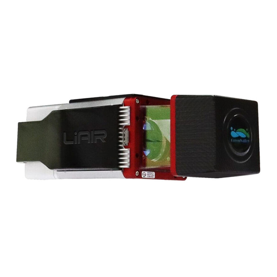
1. LiAir 250 PRO System 1.1About The LiAir 250 PRO UAV LiDAR system is lightweight professional equipment developed for multiple platforms. It integrates a LiDAR scanning system, an inertial navigation system, and a control system. It can collect high-precision point cloud data in real-time, dynamically, and massively, with the option of on-board imaging and photogrammetric information. - Page 7 GVI-2021112906 Figure 1 LiAir250 PRO system Weight:135g...
-
Page 8: System Basics
GVI-2021112906 Weight:149g Weight:1860g 1.2 System Basics LiAir250 PRO is comprised mainly of three major components: LiDAR scanning system, inertial navigation system, and control & storage system, including: (1) A GPS receiver used to measure the spatial position of the LiDAR signal transmission reference point;... -
Page 9: System Principles
According to the range information and the rotation angle, the coordinates of each laser point are quickly calculated, stored in the storage control unit. 1.4 Technical Specification LiAir 250 PRO Specifications RIEGL standard 330m@80@; Max. Scan Range parameters 170m;ρ≥20%... - Page 10 GVI-2021112906 Refer to the miniVUX- -10°C up to +40°C Temperature Range 3UAV standard (operation) (mini1-mini2) Refer to APX 15 standard, APX 20 (IMU APX-15 UAV 90) is optional IMU Data Rate 200Hz Integrated Navigation Measurement Range: ±6g/±300dps System Refer to APX 15 RTK 0.18 True Heading(deg) standard...
-
Page 11: Liair 250 Pro System Components
GVI-2021112906 2. LiAir 250 PRO System Components 2.1 Inertial navigation system The attitude positioning system is formed by GNSS, IMU, and attitude processing software. Its main function is to provide the position and attitude information of the LiDAR system through GNSS and IMU data processing. - Page 12 GVI-2021112906 source and the photoelectric detection sensor as the receiving element. The distance and angle are measured and recorded according to the principle of laser ranging to determine the orientation information of the measured object. The transmitter in the LiDAR emits an ultra-short light pulse hitting the object and diffusely reflected back to the receiver.
-
Page 13: Control And Storage Unit
GVI-2021112906 Scan Range 0.3 m ~ 250 m (@reflectivity≥60%) ± 15mm Accuracy Precision 10mm Laser Pulse Repetition Rate 10Hz~300Hz Angle Measurement Resolution 0.001° Measurement Rate 200,000Pts/sec 360° FOV (horizontal) Laser Product Classification Class 1 Eye-safe Interfaces WLAN IEEE802.11, RS232 Power Supply Input Voltage 11 - 34 V DC / typ. -
Page 14: Camera Unit (Standard Module)
Control and storage unit LED light explanation LED light Status Explanation Uniform flashing Blue0.5Hz POST, not synchronized System Stable Blue Scanner synchronization is normal Rapid flashing Blue2Hz Start data recording 2.4 Camera Unit (Standard Module) Modified Sony CAMREA is integrated on LiAir 250 PRO. -
Page 15: Ground Gps Base Station (Optional)
GVI-2021112906 Camera Specifications Model Key Specs. Parameter Sensor type APS-C type (23.5*15.6mm) Lens 16 mm fixed focal length lens Effective pixels 24.3 megapixels Sony A6000 Image Sensor Type COMS Exposure Mode Timing Weight 0.3 kg 3. Ground GPS Base Station (Optional) The main function of the ground GPS base station is to observe the same point for a long time, thereby having a high single-point accuracy as a differential reference for the UAV mobile station. -
Page 16: Base Station Setup And Operation Process
GVI-2021112906 3—Base station status indicator: used to indicate the status of the base station. 4—Save button: Base station data storage/end storage function (long press). 5—RTK rubber rod antenna interface. 6—GPS antenna feeder interface: connect the GPS antenna to the base station through the feeder cable. -
Page 17: Data Download
GVI-2021112906 power on; 2. Observe that the indicator light is steadily on; 3. Observe that the indicator light is off; 4. Observe that the indicator light is steadily on, which means that the base station has received the RTK data and is transmitting. 5. -
Page 18: Data Storage And Download
04_SYS_LOG: This folder stores system log files. 05_CAM_RAW: This folder stores camera files (not common to all devices). LiAir 250 PRO SN2222989.cal: This file is the calibration parameter file of the device. Note: data download via both Wi-Fi and network cable is supported. SD card data can be... -
Page 19: Camera Data Download
GVI-2021112906 directly accessed through the network for data management on the desktop. Figure 8 Direct access to SD card via Wi-Fi 4.2 Camera Data Download The camera data is stored in the camera's SD card, and the image data download can be completed by removing the camera's SD card directly. -
Page 20: Operation Notice & Equipment Maintenance
GVI-2021112906 Operation Notice & Equipment Maintenance The LiAir250 PRO system integrates several high-precision instruments. Please handle it with care. Avoid direct impact to the system. Always store all items properly in the protective case before transporting. Do not move or transport the system unprotected. This product should be stored and transported in the protective case provided by or authorized for use by GVI. - Page 21 GVI-2021112906 Tampering with the product is strictly prohibited and will void the Product Warranty. Any repair, modification, or upgrade must be performed by a GVI technician or authorized service provider. This product is a high-precision mapping and surveying instrument that must be handled with care.
Need help?
Do you have a question about the LiAir 250 PRO and is the answer not in the manual?
Questions and answers