
Related Manuals for GreenValley LiAirX3-H


Summary of Contents for GreenValley LiAirX3-H
- Page 1 LiAir X3-H User Guide • GreenValley International Inc. LiAir X3-H UAV LiDAR System User Guide GreenValley International Inc.
-
Page 2: Table Of Contents
LiAir X3-H User Guide • GreenValley International Inc. Table of Contents Read This First ......................1 LiAir X3-H System ....................4 Technical Specification ................... 5 Product Structure ................... 7 Product Composition ..................9 Laser Scanner ..................9 Position and Orientation System (POS) .......... 12 Control and Storage Unit .............. - Page 3 LiAir X3-H User Guide • GreenValley International Inc. LiAir X3-H Data Download ................29 Base Station Data Download ............... 29 Data Processing ....................30 Project Folder Structure ................30 Open Project ....................32 Select and Configure Parameters ............... 32 POS Processing Settings ..............33 Laser Scanner Settings ..............
-
Page 4: Read This First
LiAir X3-H User Guide Read This First Read This First Important Notices 1. LiAir X3-H system use Class 1 (IEC60825-1:2014) eye-safe laser sensors. If you have any concerns, please contact GVI for details. 2. Please read this manual carefully before operating the system, and the system operator must be at least 18 years old. - Page 5 LiAir X3-H User Guide Read This First do not insert other objects other than the connector. 7. Tampering with the product is strictly prohibited and will void the Product Warranty. Any repair, modification, or upgrade must be performed by GVI technician or authorized service provider.
- Page 6 LiAir X3-H User Guide Read This First handle it on your behalf. GreenValley International Inc. reserve the right to explain the above terms. GreenValley International Inc. April 2 , 2022...
-
Page 7: Liair X3-H System
It can be mainly used for topographic mapping, forestry surveying, power inspection, etc. With the LiPlan, LiGeoreference, LiDAR360 software developed by GreenValley International, it can provide users with complete surveying and mapping solutions. The LiAir X3-H system integration is comprised of multiple technologies, including: 1. -
Page 8: Technical Specification
LiAir X3-H User Guide LiAir X3-H System 3. Laser ranging equipment used to measure the distance between the laser signal emission reference point and the ground point, that is, the core part of the entire integrated system, the laser scanner. 4. - Page 9 LiAir X3-H User Guide LiAir X3-H System @100 klx) 230 m @ 20% reflectivity 320 m @ 80% reflectivity Field of View (Repetitive Mode) 70.4° (horizontal) × 4.5° (vertical) Number of Returns Triple Return 240,000 points/s (first or strongest return) Scan Rate 480,000 points/s (dual return) 720,000 points/s (triple return)
-
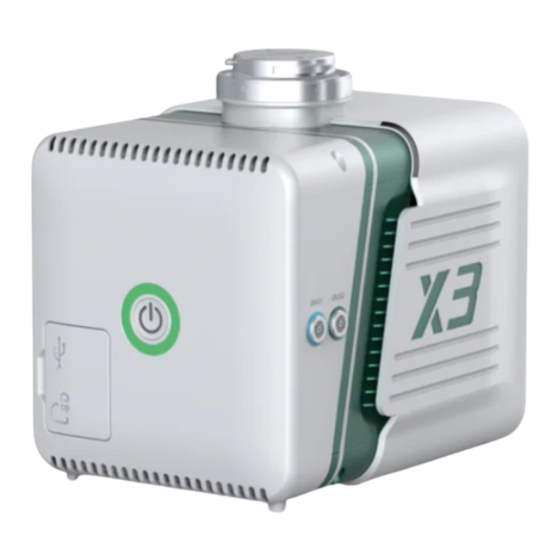
Page 10: Product Structure
LiAir X3-H User Guide LiAir X3-H System Drone Model DJI M300 RTK (ideally) Display and Control Application LiPlan Georeferencing Software LiGeoreference Product Structure 1— Power Port (PWR): Connects the power cable to power up the system. 2— Switch button (ON/OFF) and indicator light: powers the system on and off, also used to create project (shared), display system working status. - Page 11 LiAir X3-H User Guide LiAir X3-H System Explanation of ON/OFF button operation and LED light status descriptions: Color/Status Description Flashing Red (Four System is powered on and initializing Times a Second) Solid Green System initialization completed Flashing Green The project has been created, the inertial navigation data is being recorded, and the system is working normally Flashing Red...
-
Page 12: Product Composition
LiAir X3-H User Guide LiAir X3-H System 5. The laser scanner is not synchronized Product Composition Laser Scanner The laser scanner is the core of the system. The LiDAR uses the laser as the emitting light source and the photoelectric detection sensor as the receiving element. - Page 13 LiAir X3-H User Guide LiAir X3-H System of non-repetitive scanning and repetitive scanning. This product uses the repetitive scanning mode, with a FOV of 70.4 ° horizontally and a FOV of 4.5 ° vertically, as shown in the figure below. Horizontal Unit: mm Please note that the effective range of Livox Avia is different in different FOV...
- Page 14 LiAir X3-H User Guide LiAir X3-H System (Sunny, Outdoor 230 m @ 20% reflectivity @100 klx) 320 m @ 80% reflectivity 2 cm (Tested in an environment at a temperature of Distance Random 25℃ with a target object that has a reflectivity of 80% Error (1σ@20m) and is 0.2 meters away.) Angular Random Error 1σ<0.05°...
-
Page 15: Position And Orientation System (Pos)
LiAir X3-H User Guide LiAir X3-H System IP Rating IP67 Note: The laser sensor cannot be directly irradiated with strong laser light (including two sensors facing the light), so as to avoid high-intensity laser damage to the receiving sensor. Position and Orientation System (POS) The airborne Position Orientation System (POS) is an inertial measurement unit (IMU) and Global Navigation Satellite System (GNSS). -
Page 16: Control And Storage Unit
LiAir X3-H User Guide LiAir X3-H System gyroscope, 3-axis MEMS accelerometer and dual GNSS/BD receivers into one system, the POS system. Together the POS system components gather multi-reference parameters that provide accurate, effective and reliable by optimization algorithm of integrated navigation system. 3. -
Page 17: Gnss Base Station
LiAir X3-H User Guide LiAir X3-H System Effective Pixels 26 megapixels Picture Element Size 3.76 um Image Size 6252 * 4168 DFOV 83° GNSS Base Station The main function of the ground GNSS base station is to observe the same point for a long time, so that it has a high single-point accuracy and serves as a differential reference for the UAV mobile station. - Page 18 LiAir X3-H User Guide LiAir X3-H System 3—System Status Indicators: Used to indicate base station status 4—RTK Button (Cancelled) 5—Save Button: Base station data storage/end storage function (long press) 6—RTK Antenna Port 7—GNSS Antenna Port: Connect GNSS antenna and base station through feeder cable 8—RTK Antenna Base Station Indicator Lights:...
- Page 19 LiAir X3-H User Guide LiAir X3-H System Flashing Locating satellites Orange Solid Orange Satellite positions locked Base Station Specifications: System Signals 120 dynamic channels Performance GPS:L1,L2,L2C,LC GLONASS:L1,L2,L2C BDS:B1,B2 GALILEO:E1,E5a,E5b,ALtBOC,SBAS,QZSS, L-band Horizontal Single point L1: 1.5 m Positioning Single point L1/L2: 1.2 m Accuracy SBAS: 0.6 m DGPS: 0.4 m...
- Page 20 LiAir X3-H User Guide LiAir X3-H System Initialization reliability: >99.9% Positioning 0.2/m Accuracy Data Update Raw data: up tp 50 Hz Rate Position data: up to 50 Hz First Position Cold start: <50 s Time Warm start: <35 s Dimensions Dimensions 130 X 90 X 32 and Electrical...
-
Page 21: Product Components
LiAir X3-H User Guide Product Components Product Components ① LiAir X3-H LiDAR System ② USB Cable ③ GNSS Antenna Kits ④ GNSS Antennas ⑤ 256GB TF Card ⑥ TF Card Reader ⑦ USB Flash Drive ⑧ Assembly Tool ⑨Documentation/User Guide Note: Please refer to the actual product list for delivery. -
Page 22: Data Acquisition
LiAir X3-H User Guide Data Acquisition Data Acquisition Set Up GNSS Base Station 1. Select an open area for positioning Place the GNSS antenna at an open area in order to ensure the antenna can get access to the GNSS satellites as many as possible. Apart from this, the placement spot of the GNSS antenna should be stable and far away from the electromagnetic interference. - Page 23 LiAir X3-H User Guide Data Acquisition Note: When connecting the base station and the base station power cable, you need to align the red dot on the power cable with the recessed part of the interface before connecting. 3. Calculate the antenna height Measure the oblique distance from antenna bottom edge to the ground for more than three-times, take the mean value as H1.
- Page 24 LiAir X3-H User Guide Data Acquisition Actual base station antenna height = Take the above picture as an example, if the height of the measuring instrument is 1.6 meters, the actual height of the base station antenna is: Antenna Height= 4.
-
Page 25: Device Installation
LiAir X3-H User Guide Data Acquisition always on. b) Wait for the orange GPS satellite signal light to become solid (in this case, the GPS signal is stable), press and hold the Save button(>2s), release the button, indicator light will turn on and start recording data. - Page 26 LiAir X3-H User Guide Data Acquisition 2. Install the GNSS Antenna Kits, GNSS1 is connected to the rear antenna, and GNSS2 is connected to the front antenna (front refers to the flight direction). 3. Make sure there is enough space for the TF card and insert it into the system,...
-
Page 27: Parameter Setting
LiAir X3-H User Guide Data Acquisition then remove the dust cover from the bottom of the device. 4. Turn on the controller and power on the drone. 5. Press and hold the ON/OFF button of the device for more than 3 seconds to turn it on. - Page 28 LiAir X3-H User Guide Data Acquisition b) Enter http://192.168.1.88 in the browser to open the LiAir X3-H web configuration interface, user name: root, password: 888888. Click "System Settings" to set device parameters. Note: Google Chrome or IE11 browser is recommended. 2.
- Page 29 LiAir X3-H User Guide Data Acquisition 3. Parameter Settings This document only introduces common device parameters. For complete parameter descriptions, please refer to the LiAcquire-Web manual. a) Control Mode This section can be used to configure the laser and camera data acquisition modes.
-
Page 30: Workflow
LiAir X3-H User Guide Data Acquisition 1-50s. The distance mode is equidistant triggering, and the camera is triggered according to the set distance interval, the default is 10m. Configure Information: Set the time or distance interval, which is the same to the “Camera Interval”... - Page 31 LiAir X3-H User Guide Data Acquisition 7. Power off the drone. Note: In order to improve the accuracy of the inertial navigation data, it is recommended that the LiDAR unit remains in static mode for 5 minutes after starting the project before taking off. Figure-of-8 Calibration maneuvers before landing may also improve data quality.
-
Page 32: Data Downloading
LiAir X3-H User Manual Data Downloading Data Downloading LiAir X3-H Data Download LiAir X3-H data is stored in the TF card, including project files, LiDAR data, IMU data, log files, etc. Insert the TF card into the computer, and copy the corresponding project files to the computer (Not the folder with _NAV suffix). -
Page 33: Data Processing
Data Processing LiGeoreference is a LiDAR point cloud georeferencing software developed by GreenValley which allows users to merge range measurements collected by mobile, UAV or airborne laser scanning systems with position and orientation information recorded by integrated IMU and GNSS sensors. Point clouds can also be attributed with RGB imagery using LiGeoreference’s data fusion capabilities to... - Page 34 LiAir X3-H User Manual Data Processing -Calibrate folder is used to store calibrated files (*.cal). Please notice that: do not remove or delete this folder, otherwise, the performance of georeferencing will fail. -Cam folder is used to store the information of exposure time, location, and attitude angles of each image (.cam).
-
Page 35: Open Project
LiAir X3-H User Manual Data Processing Open Project 1. Open LiGeoreference software, Click “ File ” icon on the toolbar to open LiGeoreference project file (.live) through “Browse” icon. 2. Users can also open the project file via “Recent Projects” icon which refers to history project opened before. -
Page 36: Pos Processing Settings
LiAir X3-H User Manual Data Processing settings, pos process, target coordinate system, classification, and smooth settings. Normally, users only need to set pos process settings and target coordinate system settings. POS Processing Settings LiGeoreference software has pos calculation and point cloud calculation functions. - Page 37 LiAir X3-H User Manual Data Processing recommended to use the general mode. When the length of the trajectory is more than 10 km, the long baseline mode can be selected. (3)Load rover station data, under normal circumstances, the software will automatically read the rover station data under the project folder.
- Page 38 LiAir X3-H User Manual Data Processing When there is no precise base station coordinate, users could select "Average" mode. And the positioning principle is single point positioning, which leads to meter-level errors between the point cloud coordinates calculated by this method and the true coordinates. ...
- Page 39 LiAir X3-H User Manual Data Processing Select "External Input" under Process Mode to import .pos data. The external input function supports importing the original IMU data and the processed POS data, and the specific format includes *.pos, *.out, *.pof, *.sbtc, *.imu.
-
Page 40: Laser Scanner Settings
LiAir X3-H User Manual Data Processing Laser Scanner Settings Normally, the user does not need to change the parameters of the laser setting interface. If users want to limit the output power range by reflectivity, distance and scanning angle, users could change the range via clicking “Filter” to set the parameters. -
Page 41: Georeferencing Point Cloud Data
LiAir X3-H User Manual Data Processing interface. Uniform Color Function: sometimes the shooting is affected by the light and the uniform color function will make the light and dark more uniform, but will blur the color slightly. Georeferencing Point Cloud Data 1. - Page 42 LiAir X3-H User Manual Data Processing this document only introduces the operation process of using the "trajectory selection" tool. The way of "drawing polygon" could be found in the user manual of LiGeoreference software. (1) Click the "Select On Trajectory" button on the main interface of the software, and a table will automatically pop up at the same time, select the trajectory which needs to be georeferenced, and click OK.
- Page 43 LiAir X3-H User Manual Data Processing 2. Select Processing Module After opening the project, LiGeoreference will select “POS Process” and “Georeference” module by default. Users could check and re-choose the function modules as needed. Note: If there is no image data, please do not choose "Colorization" module, otherwise the program will prompt an error.
- Page 44 LiAir X3-H User Manual Data Processing If the user needs to view the “Trajectory Report” and the “Image Overlap Report”, click the "Trajectory Plot" (or " Trajectory Report ") or “ Image Overlap Report ” (only suitable for devices with cameras) under the "Tools" bar. a) POS Trajectory Report There are 11 POS accuracy evaluation criteria included in the software.
- Page 45 LiAir X3-H User Manual Data Processing means the number of satellites is just acceptable at that time. While the red part means the satellite number is too few to meet the requirement. The insufficient GNSS signal will result in poor data quality. If the number of satellites can be reached by the device is too few during a period of data acquisition, user can select the time period and right-click on that.
- Page 46 LiAir X3-H User Manual Data Processing PDOP: Position dilution of precision, or PDOP, shows the distribution of the GNSS satellites. Click to show the plot of PDOP. The smaller PDOP is, the better the distribution is. File Data Coverage: Click to show the plot of data coverage situation. This is used to show the data coverage relation among base station data, IMU data, and GNSS data of the moving device.
- Page 47 LiAir X3-H User Manual Data Processing Estimated Attitude Accuracy: Click to show the plot of attitude accuracy. This plot is used to show that if the accuracy exceeds the limitation of the IMU accuracy. The X-axis shows the GPS time. The Y-axis shows the attitude accuracy. Red line is for changes in Roll direction.
- Page 48 LiAir X3-H User Manual Data Processing direction. Estimated Velocity Accuracy: Click to plot the velocity accuracy. The X-axis shows the GPS time. The Y-axis shows the velocity accuracy. Red line is for velocity accuracy in East direction. Green line shows the velocity accuracy in North direction.
- Page 49 LiAir X3-H User Manual Data Processing Attitude Separation: Click to show the plot of attitude separation. This plot is used to show the difference among the angles in Roll, Heading, and Pitch directions during the forward-backward processing. The smaller the value is, the better the matching degree of the forward-backward processing is.
- Page 50 LiAir X3-H User Manual Data Processing Velocity Profile: This plot shows the changes in velocity during the data acquisition. Red line is for the changes in East direction. Green shows the changes in North direction. While the blue line shows the changes in up direction to the ground.
- Page 51 LiAir X3-H User Manual Data Processing The image overlap report lists the image overlap. The report could check whether the photos are lost.
-
Page 52: System Transportation And Maintenance
LiAir X3-H User Guide System Transportation and Maintenance System Transportation and Maintenance Operation Notice To ensure the reliable use of the system and the safety of the operation personnel, please observe the following notices during installation, use and maintenance. 1. Pay attention to the protection of the scanning lens to prevent scratches. 2. -
Page 53: Equipment Maintenance
9. Non-professionals, without permission, please do not try to disassemble the equipment, do not repair it without permission, so as to avoid accidents or aggravate the damage of the equipment. If the equipment is modified or disassembled not authorized by GreenValley International Inc., the warranty will be void. Equipment Maintenance 1. - Page 54 LiAir X3-H User Guide System Transportation and Maintenance the factory should be used. 8. If it needs to be packed separately due to special circumstances, please ensure that the packing box has a certain pressure resistance, and label the outside of the box with signs such as "Precision Instrument", "Handle with Care", "Fragile", etc.
Need help?
Do you have a question about the LiAirX3-H and is the answer not in the manual?
Questions and answers