Garmin Zumo 396 Owner's Manual
Hide thumbs
Also See for Zumo 396:
- Installation instructions manual (46 pages) ,
- Owner's manual (32 pages)
Table of Contents
Advertisement
Advertisement
Table of Contents

Subscribe to Our Youtube Channel
Related Manuals for Garmin Zumo 396


Summary of Contents for Garmin Zumo 396
- Page 1 ZŪMO® 396 Owner’s Manual...
- Page 2 © 2018 Garmin Ltd. or its subsidiaries All rights reserved. Under the copyright laws, this manual may not be copied, in whole or in part, without the written consent of Garmin. Garmin reserves the right to change or improve its products and to make changes in the content of this manual without obligation to notify any person or organization of such changes or improvements.
-
Page 3: Table Of Contents
Fuel Tracking ................7 Garmin Live Services ..............13 Enabling Fuel Tracking ............7 Subscribing to Garmin Live Services ........13 Setting a Low Fuel Warning ........... 8 Pairing Your Phone and Headset ..........13 Resetting the Fuel Tank Mileage ........... 8 Sending a Location from Your Smartphone to Your Device .. - Page 4 Charging the Device ..............21 Disabling Bluetooth Features for Your Smartphone with Device Maintenance ............. 21 Android ................. 15 Garmin Support Center ............. 21 Disconnecting a Bluetooth Device ..........16 Map and Software Updates ............21 Deleting a Paired Phone ............16 Connecting to a Wi‑Fi Network ..........
-
Page 5: Installation
, and clutch-clamp or brake-clamp bracket. Tighten the bolts to secure the base. WARNING Attaching the Power Cables to the Motorcycle Mount Garmin strongly recommends having an experienced installer ® with the proper knowledge of electrical systems install the Thread the power cable connector through the top of the device. -
Page 6: Attaching The Base Plate To The Motorcycle Mount
Tighten the nuts to secure the base plate. NOTE: The automobile mount is not included with all device models. Go to garmin.com to purchase optional accessories. Attaching the Base Plate to the Handlebar Base Plug the automotive power cable... -
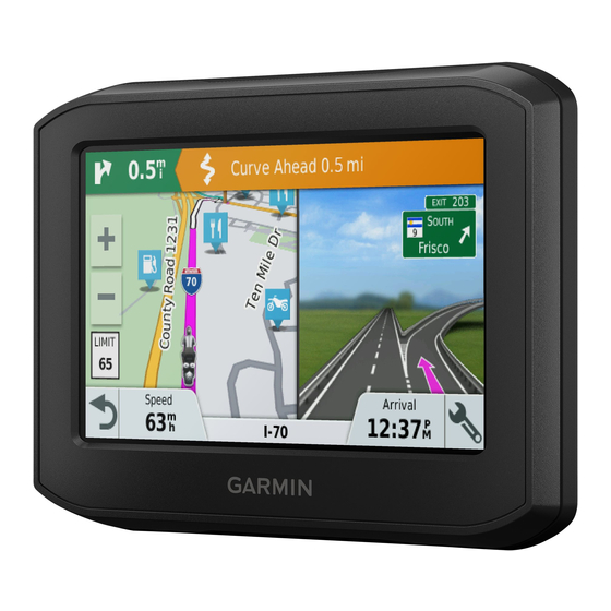
Page 7: Device Overview
Garmin is not responsible for any traffic fines or citations you information. receive for failing to follow all applicable traffic laws and signs. -
Page 8: Enabling Or Disabling Rider Alerts
Verify the contact's phone number, and select Next. NOTICE Enter your name or nickname, and select Done. Garmin is not responsible for the accuracy of or the consequences of using a red light or speed camera database. Review the sample incident message, and select Next. -
Page 9: Searching For Helmet Laws
Next action in the route. Indicates the next turn, exit, or other action drive but can be longer in distance. and the lane in which you should travel, if available. • Select Garmin Adventurous Routing™ to calculate Distance to the next action. routes that prefer curvy roads. -
Page 10: Viewing Turns And Directions
if available. A colored line indicates the proper lane for the Select Apps > Last Spot. turn. Changing Your Active Route Adding a Location to Your Route Before you can add a location to your route, you must be navigating a route (Starting a Route, page You can add locations to the middle or end of your route. -
Page 11: Using Suggested Routes
Using Suggested Routes Custom Avoidances Custom avoidances allow you select specific areas or sections Before you can use this feature, you must save at least one of road to avoid. When the device calculates a route, it avoids location and enable the travel history feature (Device and these areas and roads unless no other reasonable route is Privacy Settings, page... -
Page 12: Setting A Low Fuel Warning
Fill your fuel tank. Suggested search terms appear below the search bar. Select an option: Select Apps > Fuel Settings > Fuel Tracking. • To search for a type of business, enter a category name Select Distance Per Tank. (for example, "movie theaters"). Enter the distance the vehicle travels on a tank of gas and •... -
Page 13: Location Search Results
NOTE: Detailed parking data is not available in all areas or for all parking locations. Garmin is not responsible for the accuracy or timeliness of live parking data. Finding Parking Near Your Current Location Select Where To? > Categories > Parking. -
Page 14: Finding A City
Follow the on-screen instructions to enter street information. TripAdvisor ® Select the intersection. Your device includes TripAdvisor points of interest and ratings. TripAdvisor ratings appear automatically in the search results list Finding a City for applicable points of interest. You can also search for nearby Select Where To? >... -
Page 15: Saving Locations
Saving Locations • To zoom in or out, select • To switch between North Up and 3-D views, select . Saving a Location • To filter the displayed points of interest by category, select Search for a location (Finding a Location by Category, page •... -
Page 16: Customizing The Up Ahead Categories
(Parking, page • When not navigating a route, select Select All to reset Garmin Live Services: Provides free and paid services to send every data field except the speedometer, on the first page. live data to your device, such as red light and speed •... -
Page 17: Pairing With Your Phone And Connecting To Smartphone Link
Weather information: Sends real-time weather conditions and Garmin Live Services alerts to your device (Viewing the Weather Forecast, Before you can use Garmin Live Services, your device must be page 19). connected to Smartphone Link (Pairing with Your Phone and... -
Page 18: Smart Notifications
Bluetooth technology is compatible with your device, go to connect it to your smartphone and to the Smartphone Link app. www.garmin.com/bluetooth. From most pages, a popup appears when the device receives a notification from your smartphone. If the device is moving, you... -
Page 19: Using In-Call Options
minutes for the call history to be available. Some phones do not Disabling Smartphone Link Data and Smart support this feature. Notifications for Your Apple Device Select Apps > Phone > Call History. You can disable Smartphone Link data and smart notifications and remain connected to your phone for hands-free calling. -
Page 20: Disconnecting A Bluetooth Device
25-character code. NOTICE The traffic subscription code cannot be reused. You must Garmin is not responsible for the accuracy or timeliness of the obtain a new code each time you renew your service. If you traffic information. -
Page 21: Planning A Trip
route, a vacation, or a road trip. You can edit a saved trip to Navigating to a Saved Trip further customize it, including reordering locations, optimizing Select Apps > Trip Planner > Saved Trips. the order of stops, adding suggested attractions, and adding Select a saved trip. -
Page 22: Starting Livetrack Sharing
Starting LiveTrack Sharing Select Settings > Map & Vehicle > Map Tools > Media Player. NOTICE Open the map. Use caution when sharing your location information with others. Select > Media Player. Before you can start sharing, you must set up the LiveTrack The media player controls appear on the map. -
Page 23: Saving Your Recent Track As A Trip
The device shows the current weather conditions and a Smartphone Link, and you must have a subscription to the forecast for the next several days. photoLive service (Subscribing to Garmin Live Services, Select a day. page 13). The detailed forecast for that day appears. -
Page 24: Zūmo Settings
(Rider Awareness Features and Alerts, page Calculation Mode: Sets the route calculation method. Speeding Alert: Alerts you when you are exceeding the speed Garmin Adventurous Routing™: Sets route preferences for limit. navigating curvy roads, hills, and highways. Fatigue Warning: Alerts you when you have been driving for a Off-Route Recalculation: Sets recalculation preferences when long period without a break. -
Page 25: Units And Time Settings
You can purchase an approved Garmin AC-DC adapter Voice Language: Sets the language for voice prompts. suitable for home or office use from a Garmin dealer or Text Language: Sets all on-screen text to the selected www.garmin.com. The device may charge slowly when connected to a third-party adapter. -
Page 26: Updating Maps And Software Using A Wi‑Fi Network
Memory Card for Maps and Data, page 24). On your computer, install Garmin Express (www.garmin.com /express). This provides easy access to these services for Garmin devices: • Software updates • Map updates • Product registration Updating Maps and Software with Garmin Express You can use Garmin Express software to download and install the latest map and software updates for your device. -
Page 27: Device Care
• Do not keep your unit in the glove compartment. • Remain stationary for several minutes. • Register your device using the Garmin Express software (garmin.com/express). The device does not charge in my vehicle Resetting the Device •... -
Page 28: Computer
Garmin mapping software Link app to reduce the amount of battery power the app uses. (www.garmin.com). In addition to map and data storage, the From the Smartphone Link app on your smartphone, select memory card can be used to store files such as maps, images, geocaches, routes, waypoints, and custom POIs. -
Page 29: Transferring Data From Your Computer
• For Mac computers, drag the volume icon to the trash. Disconnect the cable from your computer. Viewing GPS Signal Status Hold for three seconds. Purchasing Additional Maps Go to your device product page at garmin.com. Click the Maps tab. Follow the on-screen instructions. Purchasing Accessories Go to garmin.com/accessories. Appendix... -
Page 30: Index
13–15 Garmin Connect 12 avoidances Garmin Express, updating software 22 area 7 Garmin Live Services 13 deleting 7 off-road navigation 7 subscribing to 13 disabling 7 on-screen buttons 3 geocaching 10 road 7 owner's manual 16 going home 5... - Page 31 Smartphone Link 13, 15, 16 connecting 13, 15 disabling calls 15 software updating 21, 22 version 21 specifications 21 speed cameras 4 subscriptions, Garmin Live Services 13 suction cup 23 theft, avoiding 23 time settings 21 tolls, avoiding 7 tools, maps 11 TracBack 18, 19 tracks 18 traffic 12, 16, 20 adding subscriptions 16...
- Page 32 February 2018 190-02397-00_0A...
Need help?
Do you have a question about the Zumo 396 and is the answer not in the manual?
Questions and answers