Table of Contents
Advertisement
Advertisement
Table of Contents

Related Manuals for Magellan Magellan GPS 315


Summary of Contents for Magellan Magellan GPS 315
- Page 1 User Manual...
- Page 2 LICENSE AGREEMENT Magellan grants you, the purchaser, the right to use the software supplied in and with MAGELLAN GPS products (the "SOFTWARE") in the normal operation of the equipment. You may make copies only for your own personal use and for use within your organization.
-
Page 3: Table Of Contents
Table of Contents Introduction ... 1 Conventions Used in this Manual ... 1 GPS 315/320 Receiver ... 2 Getting Started ... 3 Receiver Accuracy ... 3 Installing the Batteries ... 3 Proper Handling - Signal Reception ... 4 Power On ... 4 Initialize ... - Page 4 Using the NAV 2 Screen ... 12 Customizing the NAV 2 Screen ... 12 Using the Plot Screen ... 13 Selecting PAN-N-SCAN ... 14 Setting Track History ... 14 Clearing Track History ... 14 Setting Up the Plotter ... 15 Setting Hide Data/Show Data ...
- Page 5 Using DataSend™ ... 27 Working with Routes ... 28 Creating/Clearing a GOTO ... 28 Creating a GOTO on the Plotter Screen ... 28 Creating a Man Over Board Route ... 29 Creating a Backtrack Route ... 29 Creating a Multi-Leg Route ... 30 Viewing/Editing a Route ...
- Page 6 Selecting Clear Memory ... 46 Selecting NMEA ... 46 Selecting Baud Rate... 47 Connecting to DGPS ... 48 Troubleshooting ... 49 Commonly Asked Questions ... 50 Contacting Magellan ... 51 Shipping Your Receiver ... 51 NMEA Data Messages ... 52...
- Page 7 Available Datums ... 58 Specifications ... 59 Attaching the Wrist Lanyard ... 60 Accessories ... 61 Glossary ... 62 Index... 66...
-
Page 9: Introduction
Introduction Congratulations on your purchase of the Magellan GPS 315/GPS 320 receiver. Since introducing the world’s first commercial, hand-held GPS receiver in 1989, Magellan has led the way with innovative GPS products to meet a wide range of positioning and navigation needs. -
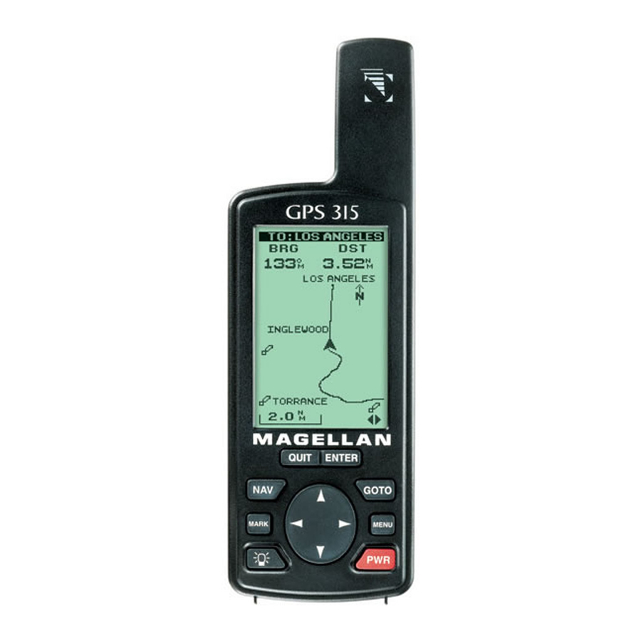
Page 10: Gps 315/320 Receiver
The GOTO key creates a direct route to any waypoint stored in memory. The MENU accesses waypoint, route and setup functions. The PWR key turns the receiver on and off. Magellan GPS 315/GPS 320... -
Page 11: Getting Started
Replace the screw and turn the ring clockwise until the battery door is held in place securely. Avoid overtightening the battery door screw. Once the batteries have been removed, the receiver loses time and date after 20 minutes. Magellan GPS 315/GPS 320... -
Page 12: Proper Handling - Signal Reception
The other steps in this procedure are not required. Select language Select ENTER area Enter ENTER time * If you do not know your elevation, press Select ENTER ENTER screen region Enter ENTER elevation Enter ENTER date ENTER Magellan GPS 315/GPS 320 ENTER... -
Page 13: Selecting Primary Usage
Speed Bearing Distance Heading Velocity Made Good Course To Steer Estimated Time of Arrival Time To Go Cross Track Error Recorded Position Units of Measure Magellan GPS 315/GPS 320 Land Marine Landmark Waypoint MILES/MPH NM/KNOTS or KM/KPH... -
Page 14: Getting A Fixed Position
A GOTO is a route that guides you from your current position to any waypoint in the receiver’s memory. Select GOTO category This completes the Getting Started section. The following Basic Operation section will familiarize you with the NAV screens and more detailed functions. MARK Select ENTER ENTER waypoint Magellan GPS 315/GPS 320... -
Page 15: Basic Operation
All screens, except STATUS and POSITION screens, can be disabled by turning them off in the NAV SCREENS portion of SETUP. The TIME screen default is off and can be turned on in SETUP as well. Magellan GPS 315/GPS 320 from any screen. While to step... -
Page 16: Using The Status Screen
This takes about 30 seconds if uninterrupted. Satellite Position Graph The two circles indicate satellite elevation, the outer circle represents the horizon and the inner circle represents 45ß from the horizon. The center of the circle is 90ß. Magellan GPS 315/GPS 320... -
Page 17: Using The Position Screen
Simulate if simulate is on. Viewing the Secondary Coordinate Screen From the POSITION screen, use the left/right ARROWs to view the Second Coordinate System access screen. Magellan GPS 315/GPS 320 When you are stationary, the receiver begins the averaging mode. -
Page 18: Using The Nav 1 Screen
Navigation Data You can change the four navigational fields. You can choose from BRG, DST, SOG, COG, VMG, CTS, ETA, ETE, XTE, TRN, ALT, TME and blank. Select Choose ENTER field CUSTOMIZE Select ENTER QUIT data type Magellan GPS 315/GPS 320... -
Page 19: Using The Compass Screen
Select From COMPASS MENU screen CUSTOMIZE Choose ENTER field Magellan GPS 315/GPS 320 When the COG Indicator and the Steering Indicator point in the same Sun Icon direction, you are on course. Compass NorthFinder™... -
Page 20: Using The Nav 2 Screen
NAV 2 screen. TO: CAMP 14.2˚ Customizable 171˚ Navigation Data 11.2 50.2 VMG, CTS, ETA, ETE, XTE, TRN, ALT, TME and blank. Select ENTER CUSTOMIZE Change ENTER QUIT field Magellan GPS 315/GPS 320... -
Page 21: Using The Plot Screen
Plot Scale Can be changed by using the left/right arrows. The scale ranges from .1 to 200 miles. Magellan GPS 315/GPS 320 Distance to Destination North Indicator Waypoint Icon Current Position Icon Track History... -
Page 22: Selecting Pan-N-Scan
This is useful when you want to return to your starting point. From PLOT MENU screen Change ENTER field Clearing Track History From PLOT MENU screen Select ENTER Select ENTER PAN-N-SCAN Select ENTER TRACK HIST Select ENTER CLR TRACK Magellan GPS 315/GPS 320... -
Page 23: Setting Up The Plotter
MENU screen PLOT SETUP Select ENTER COURSEPROJ A solid black line will appear starting from your position to the projected position. Magellan GPS 315/GPS 320 WPT NAMES WPT NAMES WPT NAMES ORIENT TRACK UP COURSE UP NORTH UP Figure A. You... -
Page 24: Setting Hide Data/Show Data
MENU screen Depending on which has been selected previously, you may need to select SHOW DATA to bring the fields into view. Select ENTER PLOT SETUP ENTER Select ENTER ENTER Select ENTER HIDE DATA SHOW DATA Magellan GPS 315/GPS 320... -
Page 25: Using The Road Screen
The ROAD screen can be changed to show the navigation data that you prefer to view. Select From ROAD MENU screen CUSTOMIZE Choose ENTER field Magellan GPS 315/GPS 320 Customizable Navigation When the Data destination icon is straight ahead, you are on course. If you are off course and... -
Page 26: Using The Speed Screen
Speed Icon ° ° Instantaneous Speed Graphical 14.2 Speedometer ODOMETER 0 0 5 4 2 Odometer TRIP Trip 0 5 4 Odometer Instantaneous Speed A graphical representation of speed over ground (SOG). Select ENTER ODOM RESET ENTER Magellan GPS 315/GPS 320... -
Page 27: Resetting The Trip Odometer
You may want to reset the Speed Average field in your receiver. Select From SPEED MENU screen SPEED AVG Select ENTER time The default is 30 seconds. Magellan GPS 315/GPS 320 ENTER ENTER SPEED AVG TRIP 5 SECONDS 30 SECONDS 1 MINUTE 5 MINUTES 1 HOUR Figure B. You can set the timing for Speed Averaging. -
Page 28: Using The Time Screen
If UTM is chosen you will not be prompted to make the LOCAL AM/PM time change. and UTC. TIME 03:54:21 Time 01:09:24 OF ARRIVAL 04:34:20 Time of Arrival ELAPSED 02:24:56 Time of Arrival (OF ARRIVAL) Elapsed Time (ELAPSED) Select ENTER FORMAT ENTER Change ENTER fields Magellan GPS 315/GPS 320... -
Page 29: Resetting Elapsed Time
From the information pro- vided, you can now navigate from place to place quickly and easily. The following chapters provide you with additional information on using your receiver that build on what you have learned. Magellan GPS 315/GPS 320 ENTER... -
Page 30: Reference
Following, you will find the Customizing section. Cus- tomizing allows you to use the Setup menu to establish the options you would like to set in your receiver. Magellan GPS 315/GPS 320... -
Page 31: Working With Waypoints
GPS 320. GPS 315 GPS 320 Worldwide major Worldwide major cities cities Regional large and Worldwide large medium cities and medium cities Regional buoys, lighthouses and fixed navaids Magellan GPS 315/GPS 320 You can store up to 10 Non-User waypoint categories. -
Page 32: Creating A User Waypoint
Select data field 500,000+ 100,000 – 500,000 20,000 – 100,000 Less than 20,000 Make ENTER MARK ENTER changes Select Select User ENTER category WAYPOINTS Select MENU ENTER EDIT WPT Make ENTER ENTER changes Magellan GPS 315/GPS 320... -
Page 33: Creating/Editing/Deleting A Message In A User Waypoint
Select From any MENU NAV screen WAYPOINTS Select Select ENTER category waypoint Select ENTER DELETE WPT Magellan GPS 315/GPS 320 EDIT WPT CAMP 34˚06.56N 117˚49.60W 900 FT Make 11:23:35PM ENTER changes 12JUN97 CREATE MSG SAVE EDITS Figure C. Once... -
Page 34: Finding A Non-Userwaypoint
Select ENTER WAYPOINTS Select ENTER MENU FIND Find waypoint Select Select ENTER category WAYPOINTS Select ENTER SORT WPT Select Select ENTER category WAYPOINTS Select ENTER ENTER MENU PROJECT Make ENTER MARK changes MARK Magellan GPS 315/GPS 320... -
Page 35: Datasend™ Cd (Optional)
You can then send the waypoints to the receiver which replace all waypoints in the receiver. The default waypoints that came with the receiver can be restored at any time. Magellan GPS 315/GPS 320 Don’t worry about losing the waypoints that... -
Page 36: Working With Routes
When the crosshair is over the waypoint icon, the name is shared waypoint name is displayed at the top of the screen. with another waypoint. Select Select ENTER ENTER waypoint category Select ENTER CLEAR GOTO Select ENTER PAN-N-SCAN Select ENTER yes or no Magellan GPS 315/GPS 320... -
Page 37: Creating A Man Over Board Route
BXXPxx. XX is the BACKTRACK number and xx is the waypoint number ranging from 01 to 31. For example, your first backtrack will read B01P01. The backtrack waypoints will be listed in the menu just as other waypoints. Magellan GPS 315/GPS 320 ENTER... -
Page 38: Creating A Multi-Leg Route
When selecting a navaid for a route, be sure you are selecting the correct one because there may be navaids with the same names in different parts of the world. Select ENTER empty route Select ENTER ENTER category ENTER ENTER ENTER Magellan GPS 315/GPS 320... -
Page 39: Viewing/Editing A Route
You can replace the stream waypoint with the fishing spot. While viewing Select route waypoint Select ENTER category Select MENU ENTER REPLACE Select ENTER category Magellan GPS 315/GPS 320 MENU ACTIVATE Select route VIEW/EDIT to edit REVERSE DELETE BACKTRACK ENTER PLOT VIEW WAYPOINTS ROUTES SETUP SUN/MOON FISH/HUNT... -
Page 40: Adding A Waypoint At The End Of
ROUTES Figure C. The Select menu may read ACTIVATE Deactivate, depending on which was chosen previously. Select first Select ENTER dotted line category ENTER Select MENU waypoint Select ENTER SAVE ROUTE ENTER Select MENU route ENTER Magellan GPS 315/GPS 320... -
Page 41: Reversing A Route
You can delete the route from your receiver. Select MENU ENTER ROUTES Select MENU ENTER DELETE Magellan GPS 315/GPS 320 MENU ROUTE MENU 1 FISH ...CAMP EMPTY Select EMPTY route EMPTY EMPTY... -
Page 42: Working With Trackroute
Backtrack. This activates BACKTRACK Route by saving the Track History as a 30 leg route and activating it. There may be some track points that are close to each other causing the receiver to skip 1 or more of these legs. Magellan GPS 315/GPS 320... -
Page 43: Auxiliary Functions
ENTER Fish/Hunt Select From any MENU NAV screen FISH/HUNT Change ENTER ENTER location ENTER Magellan GPS 315/GPS 320 SUN/MOON ON: 23MAR98 RISE/SET RISE 06:55AM 05:08PM MOON RISE 07:32PM SET 01:49AM PHASE ENTER Figure A. You Change can change the... -
Page 44: Selecting The Simulate Mode
Selecting Contrast You may want to change the contrast of your receiver. You can adjust the brightness depending on your preference. From any MENU screen Adjust ENTER contrast Select ENTER SETUP Select ENTER mode Select ENTER CONTRAST Magellan GPS 315/GPS 320... -
Page 45: Selecting Alarm/Message
The alarm will sound when the GPS position is at a distance greater than the distance you have chosen. The alarm will sound until turned off or the condition is corrected. Default setting: OFF Magellan GPS 315/GPS 320 WPT NAMES WPT NAMES ATTENTION... -
Page 46: Selecting Arrival Alarm
Default setting: OFF Selecting Proximity Alarm The Proximity alarm will sound when you are within the proximity of any waypoints you have chosen that are not on the active route. Select ENTER ARRIVAL Select ENTER Magellan GPS 315/GPS 320... -
Page 47: Selecting Proximity Alarm
Therefore, when the GPS reception is poor, you will not be notified. Select While viewing ENTER Alarm/Msg screen GPS FIX Select ENTER on or off Default setting: OFF Magellan GPS 315/GPS 320 WPT NAMES WPT NAMES PROXIMITY Select field 100FT 250FT 500FT 0.2 MI 0.5 MI 1.0 MI... -
Page 48: Selecting Gps Fix Alarm
Spanish, German, Italian or Swedish) of the GPS 315 or information. GPS 320. From any navigation screen Select language MENU Select ENTER DEFAULTS ENTER Select ENTER CLEAR MSG ENTER Select MENU ENTER LANGUAGE ENTER Magellan GPS 315/GPS 320... -
Page 49: Customizing
You may find that you do not use one, or more, of the nine NAV screens provided in the receiver. You have the option to disable NAV screens, except for the STATUS and POSITION screens. Magellan GPS 315/GPS 320 MENU COORD SYS MAP DATUM... -
Page 50: Selecting A Coordinate System
DEG/MIN/ by your maps. SEC. The screen will be different for other coordinate systems. Select ENTER NAV SCREENS Select ENTER on or off Select ENTER COORD SYSTEM Select ENTER system ENTER Magellan GPS 315/GPS 320... -
Page 51: Selecting Map Datum
If you select 3D, the receiver will return to SETUP. If 2D is selected, the receiver will ask for elevation. Input ENTER elevation Default setting: 3D Magellan GPS 315/GPS 320 WPT NAMES WPT NAMES MAP DATUM WPT NAMES PRIMARY SECONDARY Figure D. -
Page 52: Selecting Time Format
TRUE, MAG- Select NETIC, MILS reference TRUE or MILS MAG. Default setting: MAGNETIC Select ENTER TIME FORMAT Input Select ENTER ENTER time value Select ENTER NAV UNITS Select ENTER units Select ENTER ENTER NORTH REF ENTER Magellan GPS 315/GPS 320... -
Page 53: Selecting Light Timer
MENU ENTER SETUP PERSONALIZE Select ENTER on or off If ON is selected: Enter ENTER name Magellan GPS 315/GPS 320 LIGHT TIMER WPT NAMES WPT NAMES WPT NAMES ALWAYS ON 15 SECONDS 30 SECONDS 1 MINUTE 2 MINUTES ENTER 4 MINUTES Figure E. -
Page 54: Selecting Clear Memory
V1.5 APA V1.5 XTE Select V2.1 GSA NMEA Figure B. You can Default setting: OFF choose from OFF, V1.5 APA, V1.5 XTE and V2.1 GSA. Select ENTER ENTER CLEAR MEMORY ENTER Select ENTER ENTER NMEA ENTER Magellan GPS 315/GPS 320... -
Page 55: Selecting Baud Rate
Select ENTER MENU SETUP BAUD RATE Select ENTER baud rate Default: 4800 baud Magellan GPS 315/GPS 320 WPT NAMES WPT NAMES BAUD RATE 1200 BAUD 4800 BAUD 9600 BAUD 19200 BAUD Select Figure C. You can... -
Page 56: Connecting To Dgps
Pin 3: Data in Pin 5: Sig. GND To use the PC interface cable to interface the GPS receiver with the DBR-2 or DBR-3, you must use a null modem (Radio Shack P/N: 26-264A) and a gender changer (Radio Shack P/N: 26-280A) to connect the GPS receiver properly. This is due to the pinout being the opposite of the DB9 connector configuration for a PC connection. -
Page 57: Troubleshooting
See Map Datum under Reference for instructions on selecting the map datum in your receiver. Check your LAT/LON format. Make sure that the format selected in COORDINATE SYSTEM (DEG/MIN/SEC or DEG/MIN.MM) is in the same format as the map you are using. Magellan GPS 315/GPS 320... -
Page 58: Commonly Asked Questions
Why is the time and date incorrect after I replace the batteries? If the batteries are removed for 20 minutes or more, the receiver will lose the time and date. The receiver will collect time and date soon after tracking a satellite. Magellan GPS 315/GPS 320... -
Page 59: Contacting Magellan
Representatives are available Monday through Friday from 7 AM to 5 PM, PST. Faxes can be sent to Customer Service at (909) 394-7070. If necessary, you can also return your receiver to Magellan for repair (please call for assistance first). If possible, please notify us before shipping the receiver by Parcel Post or UPS and include a description of the problem, your name, address and a copy of your sales receipt. -
Page 60: Nmea Data Messages
NMEA DATA MESSAGES Your GPS receiver can be set to output GPS data in the NMEA 0183 version 1.5 or version 2.1 format to interface with other marine devices or equipment. NMEA DATA MESSAGES. NMEA data is output at 4800 baud, 8, N, 1, checksum off. - Page 61 8-9 Bearing, Magnetic 10-11Distance, naut. miles Waypoint identifier Geographic Position — Latitude/Longitude GLL,1111.11,a,yyyyy.yy,a,hhmmss.ss,A*hh Latitude, N/S Longitude, E/W UTC of position Status A = Data valid Magellan GPS 315/GPS 320 9 10 (A = valid, V = invalid) 9 10 1112...
- Page 62 A = perpendicular passed at waypoint Bearing origin to destination, M/T Destination waypoint ID 11-12 Bearing, present position to destination, Magnetic or True 13-14 Heading to steer to destination waypoint, Magnetic or 9 10 11 12 13 Magellan GPS 315/GPS 320 True...
- Page 63 SC104 Type 1 or 9 update, null field when DGPS is not used Differential reference station ID, 0000-1023 Geographic Position — Latitude/Longitude GLL,1111.11,a,yyyyy.yy,a,hhmmss.ss,A*hh Latitude, N/S Longitude, E/W UTC of position Status A = Data valid V = Data not valid Magellan GPS 315/GPS 320 5 6 7 10 11...
- Page 64 1. 2) A variable number of “PRN-Elevation-Azimuth-SNR” sets are allowed up to a maximum of four sets per message. Null fields are not required for unused sets when less than four sets are transmitted. 9 10 Magellan GPS 315/GPS 320...
- Page 65 Magnetic variation, degrees (E or W) Mode Indicator The formats listed are NMEA formats and Magellan receivers may not output all of the information listed for a particular format. A complete copy of the NMEA specifications can be obtained from:...
-
Page 66: Available Datums
Provisional So. Am. 1956 SAM69 South American 1969 SCHWA Schwarzeck SICIL Sicily SIERR SWISS TANAN Tananarive Observatory 1925 THAI Indian (Thailand, Vietnam) TIMBA Timbalai TOKYO Tokyo USER DEFINED VOIRO WGS72 World Geodetic System 1972 YACAR Yacare ZANDE Zanderij Magellan GPS 315/GPS 320... -
Page 67: Specifications
Temp. Range: Operating 14˚F to 140˚F to (-10˚C to 60˚C) Storage -40˚F to 167˚F (-40˚C to 75˚C) Power: Source 2 AA alkaline or lithium batteries or 9-16 VDC with power cable Battery Life Up to 15 hours Magellan GPS 315/GPS 320... -
Page 68: Attaching The Wrist Lanyard
Attaching the Wrist Lanyard The lanyard for your GPS receiver can be easily attached by inserting the small loop of the lanyard through the ring provided on the battery door locking screw and then looping the other end of the lanyard strap through the small loop. -
Page 69: Accessories
Accessories for your receiver are available from your Magellan dealer or you can order directly from Magellan using the order card supplied with your receiver or call Magellan at (800) 669-4477 (press 3 twice to place an order). Swivel Mounting Bracket: Mounts the receiver on a surface, allowing for hands-free operation. -
Page 70: Glossary
If you are unsure of which datum to use, use WGS84. Default The value or setting automatically chosen by the unit unless otherwise directed. Can be changed in Setup. Distance. Distance from position to destination. Magellan GPS 315/GPS 320... - Page 71 1 or more legs. A route that is from waypoint A to waypoint B to waypoint C to waypoint D has three legs with the first being from waypoint A to waypoint B. Magellan GPS 315/GPS 320...
- Page 72 Time To Go. The measurement of how long it will take you to arrive at your destination. TTG is based on how fast you are moving towards the destination and the distance remaining. Magellan GPS 315/GPS 320...
- Page 73 Used to create routes. Cross Track Error. The distance, left or right, of the desired courseline. The courseline is a straight line from your present position to your destination. Magellan GPS 315/GPS 320...
-
Page 74: Index
DGPS 9 DGPS conection 48 Differences GPS 315/320 1 Disabling NAV Screens 41 Elapsed time 21 Elevation 9; 43 Entering Information 7 Estimated Position Error 9 Fish/Hunt 35 Fixed navaid 1, 62 Fixed Position 6 Magellan GPS 315/ GPS 320... - Page 75 37 Modes of operation see Simulate mode; see 2D, 3D Multi-Leg route, creating 30 Magellan GPS 315/ GPS 320 Navigation screens 7; Compass 11; disabling 41; Nav 1 10; Nav 2 12; Plot 13; Position 9; Road 17; Speed 18; Status 8;...
- Page 76 25; editing a message 25; finding a non-user waypoint 26; functions 23; naming 6; saving 6, 25; sorting a waypoint 26 Weight, receiver 59 XTE see Cross Track Error XTE alarm see Cross Track Error alarm Magellan GPS 315/ GPS 320...
- Page 78 960 Overland Court, San Dimas, CA 91773 (909) 394-5000 630321 D...