Garmin GPSMAP 296 Pilot's Manual
Portable aviation receiver
Hide thumbs
Also See for GPSMAP 296:
- Pilot's manual (168 pages) ,
- Features (6 pages) ,
- Quick reference manual (2 pages)
Table of Contents
Advertisement
Advertisement
Table of Contents

Related Manuals for Garmin GPSMAP 296


Summary of Contents for Garmin GPSMAP 296
- Page 1 GPSMAP ® portable aviation receiver pilot’s guide...
- Page 2 All rights reserved. Except as expressly provided herein, no part of this manual may be reproduced, copied, transmitted, disseminated, downloaded or stored in any storage medium, for any purpose without the express prior written consent of Garmin. Garmin hereby grants permission to download a single copy of this manual onto a hard drive...
-
Page 3: About This Manual
> NTRODUCTION BOUT ANUAL The Basic Operation in Automotive Mode section provides NTRODUCTION you with information about navigating with the GPSMAP 296 in Thank you for choosing the Garmin GPSMAP 296, an ® ® Automotive Mode. The Automotive Mode Pages and Features... -
Page 4: Table Of Contents
Aviation Nearest Categories ............18 Information about Charge Mode ............ 2 Selecting a Nearby Point as Your Destination ......19 Turning On the GPSMAP 296 ..........3 Viewing Details for a Nearby Point ..........19 Adjusting the Backlight and Volume ..........3 Viewing Communication Frequencies .......... - Page 5 Manually Setting a Course ............39 Creating Waypoints From the Map ..........58 VNAV (Vertical Navigation) ............40 Creating a Waypoint by Entering Coordinates ......59 Using the VNAV Feature ............40 Setting up VNAV ..............41 GPSMAP 296 Pilot’s Guide...
- Page 6 Map Page ................87 Manually Transitioning to the Next Waypoint ......68 Compass Page ............... 88 Navigating a Saved Route ............69 Compass Page Options ..............88 Editing a Route ................69 Using the Marine Timer ..............89 GPSMAP 296 Pilot’s Guide...
- Page 7 Receiving DSC Calls ..............91 Reset the Temperature Graph ............. 103 DSC Call List ................91 Customizing Your GPSMAP 296 ........104 DSC Log ................. 92 Setting up the System ............104 Receiving a Position Report or Distress Call ....... 92 Adding a Welcome Message ............
- Page 8 Data Field Options ............... 145 Installation Information ............132 Safety and Product Information ......... 147 Connecting the Power/Data Cable ..........132 Index .................152 Connecting Your GPSMAP 296 to a Computer ......133 Information about USB Drivers ..........133 GPSMAP 296 Pilot’s Guide...
-
Page 9: Getting Started
Unit Overview Designed with detailed electronic mapping capability, the Garmin GPSMAP 296 is a powerful navigation device suitable for use in aircraft, motor vehicles, and marine vessels. The unit comes with a built-in Jeppesen database that includes worldwide airports and VORs, plus regional NDBs, intersections, airspace boundaries, runway data, and communication frequencies. -
Page 10: Charging The Gpsmap 296
Before using the unit, you may need to charge the battery in the to an external power supply. Press and hold the red POWER key: GPSMAP 296. Simply plug the unit into an external power source to Instead of completely turning off, the unit now goes into Charge charge. -
Page 11: Turning On The Gpsmap 296
URNING N THE Turning On the GPSMAP 296 3. To turn off the GPSMAP 296, press and hold the red POWER key again. The first time you turn on your new GPSMAP 296, the receiver must collect satellite data and establish its present position. To... -
Page 12: Getting Satellite Signals
Viewing GPS Status with the GPS tab The GPS tab provides a visual reference of satellite acquisition, After you turn on the GPSMAP 296, the unit automatically begins receiver status, and accuracy. The sky view and signal strength bars searching for satellites. The GPS page is displayed while the unit give an indication of what satellites are visible to the receiver and is gathering satellite signals and acquiring a fix, which should take... -
Page 13: Receiver Status
• Lost Satellite Reception—the receiver is no longer tracking As soon as the GPSMAP 296 has collected the necessary data from enough satellites for a 2D or 3D fix. the best satellites in view to calculate a fix, the status field indicates •... -
Page 14: Gps Tab Options
New Altitude—allows you to manually enter your altitude. New Location—allows you to enter a new location automatically or using the map. When in Aviation Mode, you can enter the airport identifier. GPSMAP 296 Pilot’s Guide... -
Page 15: Learning About The Keypad
Use the Rocker key to highlight options and to enter Press MENU to display a menu of available options for data. Also use to pan the arrow on the Map page. the current page. Press MENU twice to display the Main Menu. GPSMAP 296 Pilot’s Guide... -
Page 16: Using The Gpsmap 296
Understanding Terms The position of the scroll bar indicates which portion of the list is The GPSMAP 296 unit’s advanced keypad system is designed to currently displayed. To scroll through a list, press Up or Down on allow quick, convenient selection of navigation options and data the Rocker key. -
Page 17: Selecting Options And Entering Data
To practice entering data, try marking a waypoint and customizing one of the waypoint properties, such as the waypoint name. To mark your current location as a waypoint, press and hold Selecting an option from an options menu ENTER/MARK until the New Waypoint page appears. GPSMAP 296 Pilot’s Guide... -
Page 18: Gpsmap 296 Databases
Right to drop to the next line. MapSource Detailed Maps Optional Garmin Data Cards and MapSource CD-ROMs enhance the versatility of your GPSMAP 296. With optional MapSource City Select data, you can view listings of nearby restaurants, ®... -
Page 19: Simulated Basic Navigation
To put the unit into Simulator Mode using the GPS tab: 1. Press MENU twice to display the Main Menu. To help you get to know your GPSMAP 296, you can use the unit 2. Highlight GPS from the vertical menu. -
Page 20: Simulating Navigation
ASIC AVIGATION Simulating Navigation To get a feel for navigating with the GPSMAP 296, it is a good idea to practice navigation in Simulator Mode. The following is a basic exercise for finding and navigating to a destination in Aviation Mode. - Page 21 ASIC AVIGATION To find a land destination and simulate navigation in Automotive Mode: 1. Be sure the GPSMAP 296 is set to Simulator Mode and your location is set to San Diego, California (see “Activating Simulator Mode” on page 11).
-
Page 22: Basic Operation In Aviation Mode
Aviation Mode appears below. Each of these pages has a specific use and each page is discussed later in this manual. The Aviation Mode is the default mode for the GPSMAP 296. This manual first addresses each page, such as the Map page, as displayed in the Aviation Mode. -
Page 23: Creating A Direct To
4. Press ENTER once the desired point is displayed. Details, Select Approach, Select Route, Find Land Points, and 5. With the on-screen Go To button highlighted, press ENTER. Remove Point. The GPSMAP 296 creates a course from your present position to the selected destination. Airport Identifier... -
Page 24: Viewing Details For The Destination
If necessary, use the Rocker key to select the 3. Highlight the on-screen Go To button and press ENTER. A desired tab and view the information on that tab. course is plotted from your present position to the selected destination. GPSMAP 296 Pilot’s Guide... -
Page 25: Viewing Frequency Restrictions
Some frequencies may be noted with an asterisk (*), which indicates that the frequency has usage restrictions. You can display the usage restriction information on your GPSMAP 296. To view usage restrictions for a communication Airport Tab of Details Page frequency: 1. -
Page 26: Finding A Nearby Point
You can Show Arrows (or Show Bearing) and frequency, and VOR (for duplex operations). Set Airport Criteria. Airspace—up to 15 (depending on number of alerts provided); name, time to entry (when applicable), and status. GPSMAP 296 Pilot’s Guide... -
Page 27: Selecting A Nearby Point As Your Destination
file tabs across the top of the information pages and display the desired airport data. 3. Press QUIT to return to the Nearest Pages. You can also highlight any one of the on-screen buttons to perform that action, such as Show Map or Go To. GPSMAP 296 Pilot’s Guide... -
Page 28: Viewing Communication Frequencies
Inside Airspace—you are within the boundaries of the airspace. ARTCC Tab 4. Select the desired numbered item from the list and press ENTER to display the communication information. The lowest numbers on the list are the closest communication points. GPSMAP 296 Pilot’s Guide... -
Page 29: Viewing Additional Airspace Information
TIP: When an airspace alert appears, press NEAREST to select the Airspace tab. automatically display nearest airspace information. Press NEAREST a second time to quickly display the nearest airports list. Press NEAREST a third time to display the Find Menu. Nearest Pages: Airspace Tab GPSMAP 296 Pilot’s Guide... -
Page 30: Setting Airport Criteria
To enter airport criteria: nearby airport that otherwise would be listed. 1. Press NEAREST and open the Airport tab. 2. Press MENU to display the options menu. GPSMAP 296 Pilot’s Guide... -
Page 31: Selecting An Approach
NOTE: The approaches provided in the Jeppesen database are Select the destination you want to travel to. for monitoring purposes only. The GPSMAP 296 is not an IFR- 2. Press MENU to open the options menu. Highlight Select approved instrument and should not be used as a primary source Approach and press ENTER. -
Page 32: Understanding Vectors
final approach waypoint. much like any other route with course guidance from point to point If you select Yes, the GPSMAP 296 creates an extension of the final and a turn usually required as you cross each waypoint. -
Page 33: Finding Points On Land
Finding Points on Land To take full advantage of the trip-planning capabilities of the GPSMAP 296, you can find points on the land and then create a turn-by-turn route (auto-route) to that point. For example, you can find a restaurant to eat dinner at once you land. -
Page 34: Marking A Waypoint
Waypoints are locations or landmarks you record and store in your 2. Use the Rocker key to move the arrow to the location you GPSMAP 296. They may be checkpoints on a route or significant want to save as a waypoint. -
Page 35: Creating A Flight Plan (Route)
5. The Aviation Find page (Go To page) opens allowing you to information, refer to “Creating Routes” beginning on page select an aviation point. Enter the ID, Facility name, or city. “Editing and Managing Routes” beginning on page 68. GPSMAP 296 Pilot’s Guide... -
Page 36: Following Your Flight Plan
Once you have created and activated your flight plan (or route), the course, and other information such as speed, altitude, and ETA. GPSMAP 296 guides you to the destination using a variety of tools. Use the compass in the center of the page to determine if you are Track Your Progress on the Map page on the proper course. -
Page 37: Aviation Mode Pages And Features
E6B. map and data fields: see page for information. Map Page The GPSMAP 296 features a real-time moving map that can do Data Fields much more than just plot your course. The Map page displays map Airport information (digital cartography) that includes airspace boundaries, airports, navaids, lakes, rivers, coastlines, cities, and highways. -
Page 38: Map Orientation
The system has a built-in worldwide database to 20 mile zoom scale, with more detailed coverage available through the use of the Jeppesen, BlueChart, or MapSource data. The GPSMAP 296 displays cartography as long as there is chart information available for the range you have selected. -
Page 39: Panning The Map
When a waypoint or map item is selected, it is highlighted on coordinates. screen with the name and position displayed at the top of the Panning the Map screen, along with the distance and bearing from your current location, as shown in the image to the right. GPSMAP 296 Pilot’s Guide... -
Page 40: Airspace Information
View communication frequencies by highlighting the on- screen Frequencies button and pressing ENTER. You can also use the Rocker key to highlight the Comm tab. 3. To return the to Map page, highlight OK and press ENTER. GPSMAP 296 Pilot’s Guide... -
Page 41: Clearing Unwanted Details From The Map
4. Move the arrow to the point want to measure to. The bearing and distance from the reference point and arrow coordinates are displayed in the data window at the top of the display. 5. Press QUIT to finish. GPSMAP 296 Pilot’s Guide... -
Page 42: Setting The Bug Indicator
General Tab of the Map Page Setup through 4 above. 4. Press Up or Down on the Rocker key to highlight to the desired setting and press ENTER to select the new setting. 5. Press PAGE or QUIT to exit. GPSMAP 296 Pilot’s Guide... -
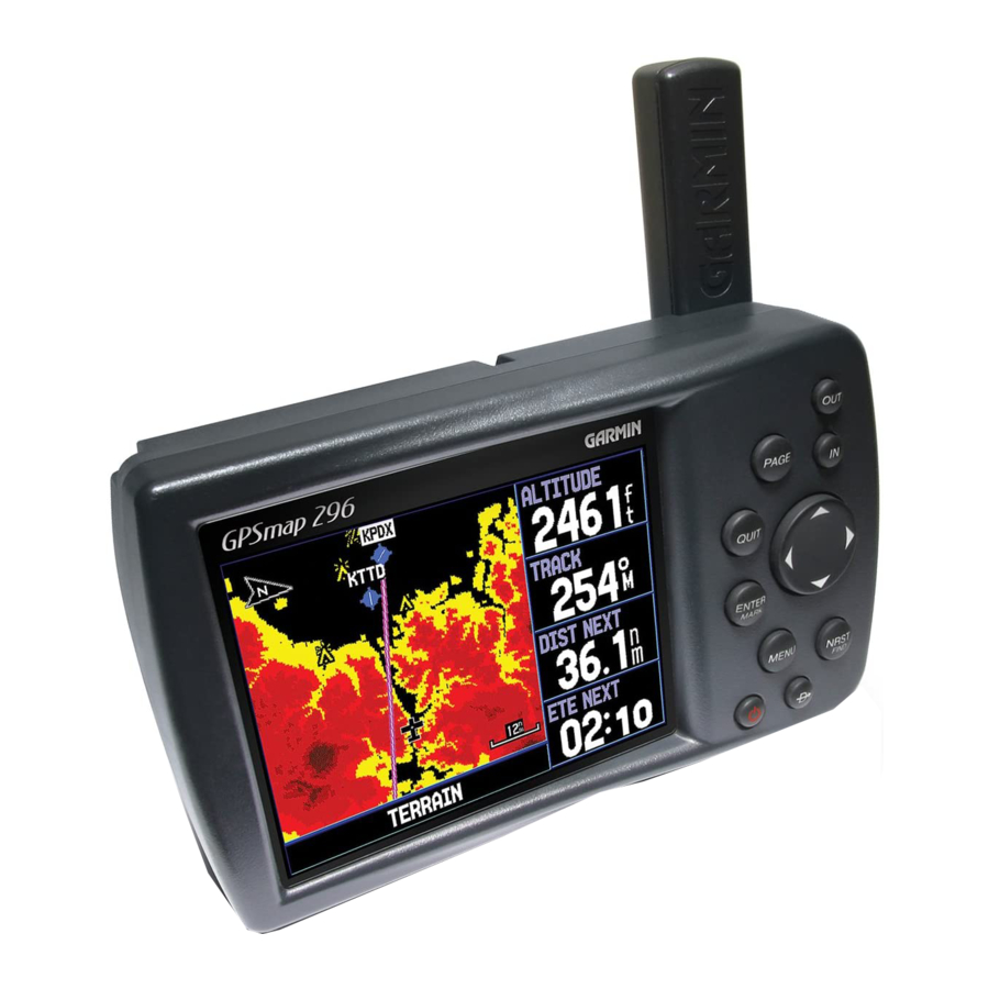
Page 43: Terrain Page
Yellow: Terrain or obstacle is between the user-defined Caution aircraft. The black areas are further than the Caution Elevation. A Elevation and 100 feet below the aircraft. projected point of impact is marked with an “X” symbol. GPSMAP 296 Pilot’s Guide... -
Page 44: Pop-Up Alerts
Pop-up Alerts Additional Terrain Page Options If you are on another page of the GPSMAP 296 unit, pop-up Terrain, Access the Terrain page options menu by pressing MENU while you Obstacle, and Descent Rate Alerts display in the lower left-hand are on the Terrain page. -
Page 45: Setting Up The Terrain Page And Alerts
The Look Ahead Time for Terrain and Obstacle Alerts determines the time when an alert annunciation (a pop-up window) occurs. For example, if 120 seconds is selected, the GPSMAP 296 will provide Terrain Setup Page an alert 120 seconds before you reach the terrain or obstacle. -
Page 46: Panel Page
GPS. The Panel page appears only when the desired course and whether you are on the desired course. A bug GPSMAP 296 is in Aviation Mode. indicator provides information to guide you back to the desired course if you stray off course. -
Page 47: Setting Up The Panel Page
ENTER to re-activate the route. ENTER. A window appears at the center of the HSI, showing the scale settings. The current setting is highlighted. 3. Use the Rocker key to select the desired scale and press ENTER. GPSMAP 296 Pilot’s Guide... -
Page 48: Vnav (Vertical Navigation)
VNAV indicator disappears from the Panel page. VNAV Indicator is On in the options menu. NOTE: The GPSMAP 296 is a VFR navigation tool and should not be used to perform instrument approaches. VNAV is only a VFR navigation instrument and is not intended for instrument approaches. -
Page 49: Setting Up Vnav
Target Altitude—enter the altitude you want to be at when you reach your target location. Select Above Waypoint to use field elevation for airports in the Jeppesen database or Above MSL to specify an exact MSL altitude target. GPSMAP 296 Pilot’s Guide... -
Page 50: Active Route Page
final destination in the Go To or route must be an airport with a published approach. Refer to page 23. Active Route Page Set Fuel Flow (Plan Route)—allows you to enter information about your aircraft and route. GPSMAP 296 Pilot’s Guide... -
Page 51: Position Data Page
Reset Odometer—clears the running total of the distance traveled since the odometer was last reset. Reset All—clears all trip information including the maximum speed and odometer. Airport is selected as the Nearest Type. The Romona (KRNM) airport is the nearest airport. GPSMAP 296 Pilot’s Guide... -
Page 52: Flight Log
The Flights tab displays a list of any recorded flights, including 2. Highlight Flights from the vertical menu of tabs. date, route of flight, and flight time. The GPSMAP 296 saves up to 50 recorded flights while in Aviation Mode. Entries on this list are 3. -
Page 53: Aircraft Information
The Aircraft Profile tab allows you to define cruising speed, 2. Use the Rocker key to select the desired aircraft profile and press ENTER. maximum speed, and fuel flow for up to ten aircraft that you regularly fly. GPSMAP 296 Pilot’s Guide... -
Page 54: Calculating The Weight & Balance
By 4. Highlight the desired weight field and press ENTER. entering the weight and arm values on this page, the GPSMAP 296 can calculate the total weight, moment, and center of gravity (CG) to 5. -
Page 55: E6B Tab
Calibrated Airspeed—required entry for density altitude/true airspeed calculation. Enter the aircraft’s airspeed indicator. Heading—required entry for winds aloft calculation. Use heading from the aircraft’s heading indicator or directional gyro. GPSMAP 296 Pilot’s Guide... - Page 56 NOTE: If a True North reference is currently selected as the outside air temperature gauge.) heading reference on your GPSMAP 296, you must enter 4. The calculated figures for True Airspeed and Density Heading using a True North reference to determine winds Altitude are displayed in the designated fields.
-
Page 57: Basic Operation In Automotive Mode
EQUENCE ASIC PERATION UTOMOTIVE This section explains some of the more common Automotive operations you will perform with your GPSMAP 296, such as creating routes and waypoints. To switch usage modes: 1. Press and hold the PAGE button. 2. Use the Rocker key to select either Aviation, Automotive, or Marine and press ENTER. -
Page 58: Navigating In Automotive Mode
3. Follow the magenta route created on the Map page. Follow the turn-by-turn route (auto-route) by using the Next Turns page and Current Route page. If you are using the external speaker, follow the voice prompts. GPSMAP 296 Pilot’s Guide... - Page 59 5. Highlight the Go To button and press ENTER. 5. The Waypoint page automatically opens. With the Go To For complete information about finding an item, refer to the button highlighted, press ENTER to begin navigation. following section. GPSMAP 296 Pilot’s Guide...
-
Page 60: Finding An Item
ENTER. The item’s information page automatically opens, allowing you to save the item as a waypoint, show the item on the map, or automatically create a route to (Go To) the item. GPSMAP 296 Pilot’s Guide... -
Page 61: Recently Found Items
The list displays items near the new map position. To find an item near another item: 1. Press the NRST/FIND key. 2. From the Find Menu, highlight the item you want to Find From, such as Coronado, CA. GPSMAP 296 Pilot’s Guide... -
Page 62: Viewing The Information Page
2. Press PAGE or QUIT to exit the information page. You can Near Current Route—compiles the Find items lists based upon the also highlight one of the on-screen buttons and press ENTER active route. to perform that operation. GPSMAP 296 Pilot’s Guide... -
Page 63: Creating Routes
To create a route using the Find Menu: 1. Press MENU twice to display the Main Menu page. The GPSMAP 296 lets you create and store up to 50 reversible 2. Use the Rocker key to highlight Route from the vertical list routes, with up to 300 waypoints each. - Page 64 4. The Active Route page opens. Press MENU. Highlight If you have selected an area of the map that is not a feature Follow Roads and press ENTER. The GPSMAP 296 or waypoint, a new waypoint is created for that location.
-
Page 65: Creating Waypoints
Waypoints are locations or landmarks you record and store in your position to create a new waypoint. You must have a valid position GPSMAP 296. They may be checkpoints on a route or significant (2D or 3D) fix to mark your present position. You can determine the ground features. -
Page 66: Creating Waypoints From The Map
You can create a waypoint using the Map page. When you pan the map and move the arrow over a map item, you will see a highlighted description of that item. The GPSMAP 296 uses the map item text shown on the map as the default name and symbol for the new waypoint. -
Page 67: Creating A Waypoint By Entering Coordinates
finished. 3. To change any of the other information, highlight the appropriate field and press ENTER. Use the rocker key to enter the new information. 4. After entering your changes, highlight OK and press ENTER. GPSMAP 296 Pilot’s Guide... -
Page 68: Following An Automotive Route
Current Route Page in Automotive Mode Whenever you have activated a turn-by-turn route in the GPSMAP The GPSMAP 296 guides you to your destination using many tools, 296 set in Automotive Mode, the Current Route page shows each such as the Map page and Current Route page. -
Page 69: Editing Your Route
6. Move the arrow to the end point and press ENTER. During Navigate Options in Automotive Mode route calculation and navigation, the GPSMAP 296 will avoid While navigating a course the area within the box or the selected area of the road. -
Page 70: Creating A Detour
If, while navigating a route, there is road construction or a closed open the Navigate menu. road, you can have your GPSMAP 296 create a detour route. While navigating a course, press the Direct To key. Select Detour 2. -
Page 71: Automotive Mode Pages And Features
When you press the Rocker Press MENU to open the options menu for the Map page. key, the GPSMAP 296 enters pan mode, which moves the map to Enter Custom Avoids so your routes will not include areas you keep the white arrow (map pointer) within the display area. -
Page 72: Highway Page
To change the highway perspective scale: • Press IN to zoom in. • Press OUT to zoom out. GPSMAP 296 Pilot’s Guide... -
Page 73: Highway Page Options
Waypoint. Each tab has On/Off settings for several options, such 3. Use the Rocker key to highlight the desired option. as enabling the line for the Active Leg and Track Log. 4. Press ENTER. Set Up Highway Highway Page Options Menu GPSMAP 296 Pilot’s Guide... -
Page 74: Current Route Page
URRENT OUTE Current Route Page Whenever you have activated a route in the GPSMAP 296 in Automotive Mode, the Current Route page shows each turn of the active route, with the distance to the turn, the street name, and estimated time to arrival and time of arrival. As you navigate a route, the turn list automatically updates to indicate the next turn at the top of the list. -
Page 75: Trip Computer
Reset the Trip Computer before beginning a trip. If you make Position Data (2 Columns) layout). The choices differ based upon frequent stops, leave the GPSMAP 296 powered on to allow the unit the Usage Mode you are currently using. -
Page 76: Editing And Managing Routes
ENTER to set the route leg transition (or waypoint transition). Select Distance to enter a radius so that when you are within the entered distance, the GPSMAP 296 will lead you to the next point on your route. When you select Manual you can transition to the next waypoint when you want while navigating a route. -
Page 77: Navigating A Saved Route
4. Use the Rocker key to enter the desired route name. Then activated. Press MENU to open the options menu. press ENTER. 5. Highlight Follow Roads and press ENTER to create a turn- by-turn route (auto-route), which is displayed in the Current Route page. GPSMAP 296 Pilot’s Guide... - Page 78 72). Once you are back on the Route Review page, the next point in the route is automatically highlighted. This allows you to review each point on the route by pressing ENTER repeatedly. GPSMAP 296 Pilot’s Guide...
- Page 79 (gallons or liters). 7. Repeat steps 4 through 6 until all desired points are added to the route. Press Quit when finished. GPSMAP 296 Pilot’s Guide...
-
Page 80: Editing And Managing Waypoints
BlueChart feature, the Waypoint Edit page will NOT display the details of the other map features. Use either of these methods to access the Waypoint page so you can edit and manage the waypoint. Waypoint Review Page Accessed from the Map Page GPSMAP 296 Pilot’s Guide... -
Page 81: Viewing The Waypoint On The Map
field you want to change, and Map page and exits the Waypoint page. press ENTER. 3. Use the Rocker key to select the desired symbol or enter data and press ENTER when done. GPSMAP 296 Pilot’s Guide... -
Page 82: Adding A Waypoint To A Route
3. Highlight the desired route or select New Route and press NOTE: You must have a GPS satellite fix before you can average ENTER. a waypoint’s location. 4. With OK highlighted, press ENTER to save the waypoint. GPSMAP 296 Pilot’s Guide... -
Page 83: Projecting A Waypoint
9. Make any other desired changes to the new waypoint data (such as the name or symbol), then highlight OK and press ENTER. Project Location Menu Enter the desired distance, bearing, and location to project from. GPSMAP 296 Pilot’s Guide... -
Page 84: Organizing Waypoints Into Categories
1. With the Waypoint Categories window open, highlight the category to delete. Press MENU. 2. Select Delete Category and press ENTER. To add a Waypoint Category, select Add and press ENTER. 3. Use the Rocker key to highlight Add and press ENTER. GPSMAP 296 Pilot’s Guide... -
Page 85: Managing Points
From the User list, you may review, edit, rename, or delete individual waypoints or delete all user waypoints. 3. Select the category you want to assign the waypoint to and press ENTER. User Points Tab GPSMAP 296 Pilot’s Guide... -
Page 86: Deleting Waypoints
NOTE: Once you delete a waypoint, you cannot recover it from 3. Press ENTER to confirm. the unit. Back up important waypoints to a computer using the USB cable and software, such as MapSource, or write them down by hand. GPSMAP 296 Pilot’s Guide... -
Page 87: Proximity Points
ENTER. When OK is highlighted, press ENTER. waypoint. 5. Highlight Delete and press ENTER to delete all waypoints within the set location. Choose Cancel or press QUIT to stop the deletion. GPSMAP 296 Pilot’s Guide... - Page 88 ENTER. entry of the proximity radius. 4. Use the Rocker key to highlight OK and press ENTER. 4. Use the Rocker key to enter a distance value (up to 99.99 units) and press ENTER. GPSMAP 296 Pilot’s Guide...
-
Page 89: Managing Your Tracks
Map page as you travel. The track log contains points along its path, including time, and position for each point. The track log starts recording as soon as the GPSMAP 296 gets a location fix. For the best results, clear the track log before you start traveling because when the track log is full, new track points overwrite the oldest track points. - Page 90 7. Highlight OK and press ENTER to save the track. Press 4. A window pops up asking if you want to save the entire track QUIT to exit. log. To save the entire track, highlight Yes and press ENTER. GPSMAP 296 Pilot’s Guide...
-
Page 91: Saved Tab
ENTER. Press QUIT to return to the Track tab. 2. Highlight the Track tab. Press the Rocker key right to 9. Highlight OK and press ENTER to save the track. Press highlight the Saved tab. QUIT to exit. GPSMAP 296 Pilot’s Guide... -
Page 92: Navigating A Saved Track
TracBack Tips eliminates the need to store waypoints along the way. TracBack Once a TracBack has been activated, the GPSMAP 296 divides routes are created by reducing your track log into a route with up to the track into segments called legs. Up to 300 temporary turns are 300 turns and activating an inverted route along those points. -
Page 93: Basic Operation In Marine Mode
ARINE This section explains some of the more common Marine operations you will perform with your GPSMAP 296. Marine Mode is very similar to Automotive Mode and Aviation Mode. For explanations of topics not discussed here that pertain to Marine Mode, refer to that topic in the Aviation Mode or Automotive Mode sections. -
Page 94: Navigating In Marine Mode
Use any of the navigation Pages to guide Position Data page to help navigate to your destination. you back to the MOB point. The MOB waypoint is stored in the waypoint list and may be deleted like any other waypoint. GPSMAP 296 Pilot’s Guide... -
Page 95: Marine Mode Pages And Features
When you press the Rocker the Map page. key, the GPSMAP 296 enters pan mode, which moves the map to Press MENU to open the options menu for the Map page. keep the white arrow (map pointer) within the display area. -
Page 96: Compass Page
(the purple tick mark on the compass ring). to your destination. For instance, if the arrow points up, you are going directly to the waypoint. If the arrow points any direction GPSMAP 296 Pilot’s Guide... -
Page 97: Using The Marine Timer
Marine Timer on the Compass Page with the GPSMAP 296 by pressing a few buttons. As discussed previously, the timer is set to count down five minutes. You must change the Compass page layout to use the Marine Timer. -
Page 98: Dsc
AGES AND EATURES Understanding Distress Calls With your GPSMAP 296 properly connected to a VHF radio with The DSC page of the Main Menu (Marine Mode only) allows you DSC output, you may receive any DSC Distress Call within range. -
Page 99: Receiving Dsc Calls
1. Open the Call List or Log from the DSC tab 2. Press Up or Down on the Rocker keypad to highlight the call you want to review. DSC Call List 3. Press ENTER to open the DSC Entry Review page. DSC Entry Review Page GPSMAP 296 Pilot’s Guide... -
Page 100: Dsc Log
Or, press MENU, highlight New Item, and press ENTER. Navigate menu is highlighted. Press ENTER to go to the location. 3. Enter the MMSI number, the Name, and any comments. 4. When finished, highlight OK and press ENTER. GPSMAP 296 Pilot’s Guide... -
Page 101: Making A Distress Call
Another way to input a name is from the Entry Review page or the DSC Distress Call or DSC Position Report pages. The Name and MMSI are sent to other Garmin GPS units: Only the MMSI numbers are sent to other non-Garmin DSC users. -
Page 102: Additional Pages And Features
The Main Menu features some additional pages that will be useful 2. Use the Rocker key to open the Alarms tab. to you as you plan trips and use your GPSMAP 296. Some of these 3. Highlight the field below the alarm name you wish activate pages have already been discussed in-depth in previous sections. -
Page 103: Airspace Alarms
Off Course—sets an alarm to sound when off your desired course. Airspace Alarms Tab Select On, then enter a distance. Anchor Drag—sets an alarm to sound when you have exceeded a specified drift distance. Select On and then enter a distance. GPSMAP 296 Pilot’s Guide... -
Page 104: System Alarms
Select On and then enter a specific distance. Drift—sets an alarm to sound when you have exceeded a specified drift distance. Select On and then enter a specific distance. Fish—sets alarm to sound when unit detects a fish of the specified symbol size. GPSMAP 296 Pilot’s Guide... -
Page 105: Using The Calendar
Sun & Moon Information or Hunt & Fish tab, highlight selected), select the route you want to add to the calendar View Sun and Moon or View Hunt and Fish and press ENTER. and press ENTER. GPSMAP 296 Pilot’s Guide... -
Page 106: Viewing Celestial Information
You can also use the play, fast forward, and stop buttons to view an Sun and Moon controls for the in the sky view animation of the Sun & Moon tab. sky view Sun & Moon Tab GPSMAP 296 Pilot’s Guide... -
Page 107: Tide Tab
3000 tide stations. The tide curve shows as a shaded area, with higher tides being taller and lower tides shorter. The bottom of the page indicates the times with the largest and smallest tides. GPSMAP 296 Pilot’s Guide... - Page 108 3. Press ENTER when finished. The unit displays the chart for the date you entered or selected. To use the current date again, highlight the Date field. Press MENU, highlight Use Current Date, and press ENTER. GPSMAP 296 Pilot’s Guide...
-
Page 109: Hunt & Fish Tab
4. On the information page, press ENTER. The unit displays the Hunt & Fish information for the selected location. To use the current location, highlight the From field. Press ENTER, highlight Current Location, and press ENTER. GPSMAP 296 Pilot’s Guide... -
Page 110: Viewing Messages
The Message tab of the Main Menu displays a list of messages 2. Highlight Message from the vertical list of tabs. generated by your GPSMAP 296. Use the Rocker key to scroll through the entire list of messages on the Log tab. Use the Log Filter 3. -
Page 111: Viewing The Temperature
NOTE: You must be receiving proper sonar data from another according to the Temperature Scale and Time Duration settings. device, such as a Garmin GSD 20 Sounder Module, to view temperature information. Temperature Scale—select the desired degree span from the list. -
Page 112: Customizing Your Gpsmap 296
The Main Menu provides access to various waypoint, system, navigation and interface management, and setup menus. Setting up the System To customize how your GPSMAP 296 sounds and looks, adjust certain system settings in the Main Menu. Welcome Tab of the Setup Tab Adding a Welcome Message Enter the desired information in the fields. -
Page 113: Changing The Page Layout And Data Fields
3. Highlight Set Up Page Layout and press ENTER. Changing a Data Field Changing the layout of the Map page 4. Select the desired option and press ENTER. The options vary between the three usage modes and the page you are setting up. GPSMAP 296 Pilot’s Guide... -
Page 114: Additional Map Data Displayed
USTOMIZING ETTING UP THE YSTEM Additional Map Data Displayed You can view the data that is currently loaded on your GPSMAP 296 unit and data card. To review/change data card information: 1. Access the Map page and press MENU. 2. From the options menu, highlight Map Information and press ENTER. -
Page 115: Changing The Display
Auto switches from day to night at sunset and changes back at 4. Highlight Restore Defaults and press ENTER. sunrise. Main Menu—enables the main menu tabs to contain text and icons (default) or text tabs only. GPSMAP 296 Pilot’s Guide... -
Page 116: Changing The Sounds
The Sound tab of the Main Menu allows you to customize the sounds your GPSMAP 296 makes to suit your needs. Voice Prompt—sets the vocal prompt to operate for Guidance and Status, Route Guidance Only, or No Voice Prompts. -
Page 117: Changing The System Settings
296 remains on (Stay On) or the unit turns off (Turn Off) when external power is removed from the unit. External Power On—allows you to turn the GPSMAP 296 on (Turn On) or charge the battery (Charge Battery) when external power is applied to the unit. -
Page 118: Customizing The Units
Pressure—select the unit to display the pressure. Fuel Tank—an estimation of the time left before you refuel. Since Midnight—the time the unit has been turned on since midnight. This will reset if you restore All Unit Defaults from the System tab. GPSMAP 296 Pilot’s Guide... -
Page 119: Changing The Time
Time Tab of the Setup Tab Time Zone—allows you to choose a city in your correct time zone so the GPSMAP 296 will show the correct local time. Select Other to enter a UTC Offset. If the incorrect date is displayed, press MENU, highlight Set Date, and press ENTER. -
Page 120: Customizing The Routing And Guidance Settings
• Faster Time—routes calculated are faster to drive but may be Settings longer in distance. You can change the way the GPSMAP 296 generates routes in • Shorter Distance—routes calculated are shorter in distance Automotive Mode. You can also change the way the GPSMAP 296 but may take more time to drive. -
Page 121: Guidance Settings
Direct To key (Held Direct Menu. Select Setup from the vertical tab list. Then select Guidance To Key Only), opens automatically (Automatically Only), or Both. from the row of tabs along the top of the page. GPSMAP 296 Pilot’s Guide... -
Page 122: Changing The Location Settings
You should only change the datum if you are using a map or chart your position changes. Failure to update this setting may result that specifies a different datum. in substantial differences between the information displayed on your unit and external references, such as a magnetic compass. GPSMAP 296 Pilot’s Guide... -
Page 123: Changing The Data Format
Menu. Select Setup from the vertical tab list. Then select COM 1 or COM 2 from the row of tabs along the top of the page. • GARMIN DGPS—used to connect the GPSMAP 296 with a Garmin DGPS beacon receiver. - Page 124 • Tuning—the unit is attempting to tune to the specified your GPSMAP 296 using the COM tab. You may have the unit frequency and bit rate. automatically scan for the DGPS beacon signal, or you can enter the •...
-
Page 125: Advanced Nmea Output Setup
Advanced NMEA Output Setup Advanced NMEA Output Setup If you are going to interface the GPSMAP 296 with another piece The Advanced NMEA Output Setup page allows you to set the of equipment (such as a radar or autopilot), the unit needs to be output rate, change the precision of the Lat/Lon minutes, set set to output NMEA data. -
Page 126: Setting Up And Using Sonar
296 when used in conjunction with a GSD 20 Sounder Module. Read the GSD 20 Installation Instructions to properly install the sounder module. When you power up your GPSMAP 296, the GSD 20 automatically powers on. NOTE: You MUST have a GSD 20 installed and connected to Map Page with Split Screen your GPSMAP 296 to use the sonar features. -
Page 127: Using The Sonar Page
The top left corner displays the Adjustment Option, the depth, and The current display mode is displayed at the bottom of each sonar the water temperature. display. Read the “Understanding Sonar” section beginning on page more on information about sonar. Sonar Page GPSMAP 296 Pilot’s Guide... -
Page 128: Adjusting The Sonar Page
Adjustment Menu displays a new selection labeled View or Span. The Zoom function is divided into six display levels: Press ENTER to accept the new setting (or press QUIT to cancel) and return to the Sonar page. GPSMAP 296 Pilot’s Guide... - Page 129 Rocker key to move the line on the sonar display. change. If the display is Bottom Split or Bottom Lock, Span adjusts how far off the bottom the unit displays data. GPSMAP 296 Pilot’s Guide...
-
Page 130: Resizing The Split Screen
4. If you wish to cancel this operation, press QUIT or press MENU, highlight Stop Resizing, and press ENTER. 4. When done, highlight OK and press ENTER. 5. To return to the standard Sonar page, press QUIT; or press MENU, highlight Hide Pointer, and press ENTER. GPSMAP 296 Pilot’s Guide... -
Page 131: Setting Up The Sonar
Transducer—select the type of transducer that you are using. If you sound waves travel through Fresh and Salt water at different rates, it are using a speed-capable transducer/sensor, select Temp, Spd. is necessary to select the Water Type to ensure accurate readings on the unit. GPSMAP 296 Pilot’s Guide... -
Page 132: Calibrating The Water Speed
If there is a problem with the speed sensor or if a speed senor is not installed, “Water Speed Sensor Is Not Working” appears at the bottom of the display. Check connections of speed sensor cables. GPSMAP 296 Pilot’s Guide... -
Page 133: Setting Up The Sonar Display
Scale—select how and where you want the depth scale to be Temperature Depth Scale displayed. Graph in corners Color Bar—select On to show a gradient scale of the current Target Level setting on the Sonar Setup tab. Sonar Page with the Sonar Display settings changed GPSMAP 296 Pilot’s Guide... -
Page 134: Understanding Sonar
The transducer collects the reflected sound waves and sends the data to the GPSMAP 296 to be processed The Sonar page does not display a three-dimensional representation and displayed. The underwater data is shown on the Sonar display in of the underwater environment;... -
Page 135: Transducer Coverage
6-foot diameter 40° Cone Angle (50 kHz) 10° Cone Angle (200 kHz) circle at a 30-foot depth. Dual frequency mode combines both frequencies to get the best coverage area and contour/depth readings. GPSMAP 296 Pilot’s Guide... -
Page 136: Whiteline
® whiteline indicates a harder bottom. Normally, a red line is used technology, which allows the GPSMAP 296 to hear both weak and to show the point where water meets the bottom. This line follows strong signals simultaneously so as to identify fish returns under the bottom contour, along with any significant objects lying on the... -
Page 137: Appendix
5°F to 140°F (-15°C to 60°C) Velocity: 0.1 knot RMS steady state Dynamics: 6 g's Power Battery: Rechargeable lithium-ion Battery Life: 5 to 15 hours depending upon the backlight setting Source: 11–35 VDC Fuse: 3AG-1.5 Amp GPSMAP 296 Pilot’s Guide... -
Page 138: Care Information
Care Information Immersing the Unit in Water The GPSMAP 296 is waterproof to IEC Standard 60529 IPX7. It can To resolve problems that cannot be remedied using this guide, withstand immersion in 1 meter of water for 30 minutes. Prolonged contact Garmin Product Support in the U.S.A. -
Page 139: Optional Accessories
Download detailed map data from MapSource CD-ROMs your Garmin Dealer, Garmin Product Support in the U.S.A. at to a data card, either directly through your GPSMAP 296 using the 800/800.1020, or Garmin Europe at 44/0870.8501241. included USB-PC Interface Cable, the optional PC Interface Cable... -
Page 140: Installation Information
2 Green White Power Voice (+) Connecting the Power/Data Cable Brown The power/data cable connects the GPSMAP 296 to an 11–35 VDC Data Out 2 Data In Violet 1 Yellow system and provides interface capabilities for connecting external devices. The color code in the diagram below and to the right indicates the appropriate harness connections. -
Page 141: Connecting Your Gpsmap 296 To A Computer
1. Connect the small end of your cable to the lower connector Your GPSMAP 296 can be connected to your computer using the on the back of the GPSMAP 296, shown in the illustration to included USB-PC Interface Cable to connect to a USB data port the left. -
Page 142: Using Ximage For Customized Waypoint Symbols
PC and your the label is facing the front of the unit. GPSMAP 296. You can download and save screen shots of any screen displayed on your unit. xImage also allows you to download 2. -
Page 143: Interfacing
GPBOD, GPRTE, and GPWPL. The following are the Proprietary Sentences for NMEA 0183, version 3.01 output: PGRME, PGRMZ, and PGRMM. The GPSMAP 296 also includes NMEA input with support for the BWC, DBT, DPT, MTW, VHW, VTG, and XTE sentences. Garmin’s proprietary communication protocol is available from the Web site (www.garmin.com). -
Page 144: Learning About Gps
There are no subscription fees or setup charges to use river systems. GPS. For more information refer to the Garmin Web site at www. The DGPS system is available for use without a fee, but you do need and also read the GPS Guide for Beginners, which can garmin.com... -
Page 145: What Is Waas
• Scanning for Beacon: The DGPS receiver is scanning for an unit with increased accuracy at any location in the world. available frequency. Currently, enabling WAAS on your Garmin GPSMAP 296 in regions What is WAAS? that are not supported by ground stations may not improve accuracy, The Wide Area Augmentation System (WAAS) is an FAA-funded even when receiving signals from an SBAS satellite. -
Page 146: Loran Td Setup
LORAN TD format mode, it simulates the operation of a LORAN receiver. Position coordinates may be displayed as TDs, and all navigation functions may be used as if the unit was actually receiving LORAN signals. GPSMAP 296 Pilot’s Guide... - Page 147 LORAN TD position. For more information please read the field, press ENTER, enter the desired setting using the Rocker key, then press ENTER. our LORAN TD Position Format Handbook, available at the Garmin Web site, at www.garmin.com/support/userManual.html. GPSMAP 296 Pilot’s Guide...
-
Page 148: Map Datums And Location Formats
Using a Garmin GPS with Paper Land Maps, available are referenced to a specific map datum. Every chart has a map datum reference and the GPSMAP 296 can be set to match most of those for download at http://www.garmin.com/manuals/UsingaGarminGP... -
Page 149: Digital Selective Calling (Dsc)
VHF radio with the FCC (Form 605). An emergency DSC Distress Call allows a vessel in trouble to Garmin does not supply this number! transmit a substantial amount of information in a single transmission or “call,” without the need for voice communication. When any For more information regarding MMSI’s visit... -
Page 150: How Are Mmsi Assignments Obtained
(on sea or land) within range can receive the call. United States Federal User When the Garmin GPSMAP 296 is connected to a VHF with DSC Federal users can obtain MMSI assignments from their agency support, the GPS unit displays a Call List, Log, and a Directory. -
Page 151: Jeppesen Database Information
Jeppesen Database points. NDBs—* identifier, facility name, city/state/country, position An optional FlightBook software package is available to assist with (latitude/longitude), and frequency. your flight record keeping. Visit the Garmin Web site at http://www. Intersections—identifier, nearest VOR, radial and distance from garmin.com/aviation. -
Page 152: Messages
All MapSource maps are not accessible. Water Alarm. Database Error: Internal problem with the unit. Contact your dealer or Garmin Track Already Exists: A saved track with the same name already exists. Product Support to have the unit repaired. -
Page 153: Data Field Options
Some of these options are supported only by devices next point on your route. interfaced to your GPSMAP 296. Est. Time to VNAV: (Aviation Only) The estimated time required to reach the Accuracy: The current accuracy of your GPS determined location. - Page 154 Waypoint (Next): The next waypoint in your route. Displayed as Next Wpt. Trip Avg. Speed (Total): The total average speed traveled since the last reset of the Trip Computer. Displayed as Ttl Avg Spd. Trip Odometer: The total distance traveled since the Trip Computer was reset. GPSMAP 296 Pilot’s Guide...
-
Page 155: Safety And Product Information
Use this area to record the serial number (8-digit number located Software License Agreement on the back of the box) in case your GPSMAP 296 is lost, stolen, BY USING THE GPSMAP 296, YOU AGREE TO BE BOUND BY THE or needs service. -
Page 156: Limited Warranty
SHALL BE YOUR SOLE AND EXCLUSIVE REMEDY FOR ANY BREACH The GPSMAP 296 is fastened shut with screws. Any attempt to open the case OF WARRANTY. to change or modify the unit in any way will void your warranty and may result in permanent damage to the equipment. -
Page 157: Fcc Compliance
NFORMATION FCC Compliance Safety Information The GPSMAP 296 complies with Part 15 of the FCC interference limits for WARNING: The GPSMAP 296 contains a lithium-ion rechargeable Class B digital devices FOR HOME OR OFFICE USE. These limits are battery. The battery used in this device may present a risk of fire designed to provide more reasonable protection against harmful interference in or chemical burn if mistreated. - Page 158 AFETY AND RODUCT NFORMATION CAUTION: Use the GPSMAP 296 at your own risk. To reduce WARNING: The Global Positioning System (GPS) is operated by the risk of unsafe operation, carefully review and understand all the United States government, which is solely responsible for its aspects of this Pilot’s Guide—and thoroughly practice operation...
- Page 159 WARNING: For use in vehicles, it is the sole responsibility of the Do Not Mount in Front of an Airbag Field of Deployment owner/operator of a vehicle to place and secure the GPSMAP 296 so it will not interfere with the vehicle operating controls and safety WARNING: When used in vehicles, it is the sole responsibility devices, obstruct the driver’s view of driving conditions, or cause or...
-
Page 160: Index
1, 3, 135 Connecting the Power Cable 2, 132 Calibrate Water Speed Boundary 29, 32 Append to Route Contact Garmin Cards, Data Information 20, 21, 32 Approach 17, 23, 24, 42 Course Deviation Indicator 24, 38, GPSMAP 296 Pilot’s Guide... - Page 161 Distance and Speed DB-9 Page 6, 68 Finding a Nearby Aviation Point Distress Calls 90–93, 141–142 Declutter GRI Chain 18–22 Drift Alarm Defaults 8, 105, 111 GSD 20 Fishing Information 90–93, 141–142 Delete Guidance Tab Fish Symbols GPSMAP 296 Pilot’s Guide...
- Page 162 Obstacle Alert Move around the Map Man OverBoard Odometer MapSource 10, 134 Off-Route Recalculation Keypad Map Data Navigate Off Course Map Data Information Route Off Road Map Datum To Point On-Screen Button Land at Closest Point GPSMAP 296 Pilot’s Guide...
- Page 163 118, 119–122 Power Outlet Add Points Scan for a Frequency Adjusting 120–122 Practice Mode. See Simulator Mode Add Waypoint to Scroll Bar On the Map Page Preferences Edit 70, 71 Searching the Sky Setting Up 123, 125 GPSMAP 296 Pilot’s Guide...
- Page 164 Warning Page Thermoclines Waterproof Tide U-Turns Water Speed Chart Underwater Waypoints Water Temp Information Units Tab Waypoint 16, 26, 57–59, 136 Station Unpaved Roads Categories 76, 77 Updates to Jeppesen Database Create 26, 58, 75 Time GPSMAP 296 Pilot’s Guide...
- Page 166 For the latest free software updates (excluding map data) throughout the life of your Garmin products, visit the Garmin Web site at www.garmin.com. © Copyright 2004 Garmin Ltd. or its subsidiaries Garmin International, Inc. 1200 East 151 Street, Olathe, Kansas 66062, U.S.A.