Garmin GPSMAP 6008 Owner's Manual
Gpsmap 6000/7000 series chartplotter
Hide thumbs
Also See for GPSMAP 6008:
- Declaration of conformity (6 pages) ,
- Template manual (2 pages) ,
- Owner's manual (132 pages)
Table of Contents
Advertisement
Advertisement
Table of Contents

Related Manuals for Garmin GPSMAP 6008


Summary of Contents for Garmin GPSMAP 6008
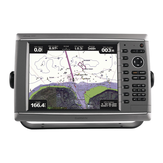
- Page 1 GPSMAP series 6000/7000 ® owner’s manual...
- Page 2 Information in this document is subject to change without notice. Garmin reserves the right to change or improve its products and to make changes in the content without obligation to notify any person or organization of such changes or improvements.
-
Page 3: Tips And Shortcuts
Introduction Introduction WARNING See the Important Safety and Product Information guide in the product box for product warnings and other important information. This manual includes information for the following products: • GPSMAP 6008 ® • GPSMAP 6208 • GPSMAP 6012 •... -
Page 4: Table Of Contents
Incoming Distress Calls ��������������������������������� Waypoints �������������������������������������������������������� Man-Overboard Distress Calls Initiated from a Routes ������������������������������������������������������������� VHF Radio ���������������������������������������������������111 Tracks �������������������������������������������������������������� Man-Overboard Distress Calls Initiated from the Navigating with a Garmin Autopilot������������������ Chartplotter ��������������������������������������������������111 Where To? �����������������������������������������������42 Position Tracking ��������������������������������������������111 Marine Services Destinations ��������������������������... - Page 5 Calibrating the GPSMAP 7000 Series Touchscreen ������������������������������������������������ Screenshots��������������������������������������������������� Viewing GPS Satellite Locations ������������������� System Information���������������������������������������� NMEA 0183 and NMEA 2000 ������������������������ Product Registration �������������������������������������� Contact Garmin ��������������������������������������������� Declaration of Conformity ������������������������������ Software License Agreement������������������������� Index ������������������������������������������������������123 GPSMAP 6000/7000 Series Owner’s Manual...
-
Page 7: Getting Started
Getting Started Getting Started Front and Back Panels ➊ ➋ ➌ ➍ ➎ ➏ ➐ ➑ GPSMAP 6012 and 6212 Front View ➊ ➋ ➑ GPSMAP 7015 and 7215 Front View ➊ Power key ➋ Automatic backlight sensor ➌ Range keys ➍... - Page 8 Getting Started ➋ ➌ ➍ ➎ ➊ GPSMAP 6008, 6208, 6012, 6212, 7012, and 7212 Back View ➊ ➎ ➍ ➋ ➌ GPSMAP 7015 and 7215 Back View ➊ Network connectors ➋ NMEA 2000 connector ➌ NMEA 0183 connector ➍...
-
Page 9: Turning On The Chartplotter
. When the chartplotter loses satellite signals, the green bars disappear and a flashing question mark appears on the boat icon on the chart screen. For more information about GPS, visit the Garmin Web site at www.garmin.com/aboutGPS. Adjusting the Backlight 1. From the Home screen, select Configure >... -
Page 10: Inserting And Removing Data And Memory
® ® satellite imagery and aerial reference photos of ports, harbors, marinas, and other points of interest. Insert blank memory cards to transfer data such as waypoints, routes, and tracks to another compatible Garmin chartplotter or a computer (page 69). The SD card slot is located on the front of the chartplotter. -
Page 11: About The Home Screen
Note: Mariner’s Eye 3D, Fish Eye 3D, and the Fishing Chart are available only if you use a BlueChart g2 Vision data card (page 21). • Sonar—sets up and provides sonar information (only available if the chartplotter is connected to a Garmin sonar module) (page 99). -
Page 12: Charts And 3D Chart Views
Charts and 3D Chart Views Charts and 3D Chart Views All GPSMAP 6000/7000 series chartplotters have a basic worldwide imagery map. The GPSMAP 6208, 6212, 7212, and 7215 chartplotters have built-in detailed BlueChart g2 offshore cartography for US waters. The charts and 3D chart views listed below are available on the chartplotter. -
Page 13: Chart Symbols
Charts and 3D Chart Views Chart Symbols BlueChart g2 and BlueChart g2 Vision charts use graphic symbols to denote map features, which follow the standards for US and international charts. Some common symbols you might see include, but are not limited to, those shown below. - Page 14 Charts and 3D Chart Views Panning the Navigation or Fishing Chart You can pan away from your current location and to other areas on the Navigation chart or the Fishing chart. Note: The Fishing chart is available with a preprogrammed BlueChart g2 Vision data card. 1.
- Page 15 Charts and 3D Chart Views Viewing Location and Object Information on a Chart You can view information about a location or an object on the Navigation chart or the Fishing chart. Note: The Fishing chart is available with a preprogrammed BlueChart g2 Vision data card. 1.
-
Page 16: Viewing Tide Station Information
Charts and 3D Chart Views Viewing Tide Station Information Tide-station information appears on the chart with a tide station icon. You can view a detailed graph for a tide station to help predict the tide level at different times or on different days (page 46). - Page 17 Charts and 3D Chart Views Navigation Chart Appearance Changing the Map Orientation You can set the perspective of the map in the Navigation chart or the Fishing chart. Note: The Fishing chart is available with a preprogrammed BlueChart g2 Vision data card. 1.
- Page 18 Charts and 3D Chart Views Showing and Configuring the Heading Line The heading line is an extension drawn on the map from the bow of the boat in the direction of travel. You can configure the appearance of the heading line for the Navigation chart or the Fishing chart. Note: The Fishing chart is available with a preprogrammed BlueChart g2 Vision data card.
- Page 19 Charts and 3D Chart Views Configuring Depth Shading You can customize the appearance of depth shading on the Navigation chart. Note: Depth shading is available with a preprogrammed BlueChart g2 Vision data card. 1. From the Home screen, select Charts >...
-
Page 20: Automatic Identification System
Charts and 3D Chart Views Showing Marine Service Points From the Home screen, select Charts > Navigation Chart > Menu > Chart Setup > Service Points > Showing and Configuring Roses On the Navigation chart or the Fishing chart, you can show a compass rose around your boat, indicating compass direction. - Page 21 Charts and 3D Chart Views AIS target Dangerous AIS target Tracking AIS target Closest point and Lost time of approach to dangerous dangerous target AIS target Lost AIS target AIS Targeting on the Navigation Chart AIS Targeting Symbols Symbol Description AIS vessel�...
- Page 22 Charts and 3D Chart Views When course over ground, heading, and rate of turn information are provided by an activated AIS target, the projected course of the target is calculated based on the course over ground and the rate of turn information. The direction in which the target is turning, which is also based on the rate of turn information, is indicated by the direction of the barb at the end of the heading line.
- Page 23 Charts and 3D Chart Views • Select Display Range to indicate the distance from your location in which AIS vessels appear. Select a distance. • Select MARPA > Show to show MARPA-tagged vessels. • Select Details > Show to show details about AIS-activated and MARPA-tagged vessels. •...
- Page 24 Charts and 3D Chart Views 4. Select time to to sound an alarm if AIS or MARPA determines that a target will intersect the safe zone within the defined time interval (ranging from 1 to 24 minutes). 5. Select a time. Viewing a List of AIS and MARPA Threats Note: The Fishing chart and Mariner’s Eye 3D are available with a preprogrammed BlueChart g2 Vision data card.
-
Page 25: Perspective 3D
Charts and 3D Chart Views Perspective 3D Perspective 3D provides a view from above and behind the boat (according to your course) and provides a visual navigation aid. This view is helpful when navigating tricky shoals, reefs, bridges, or channels, and is beneficial when trying to identify entry and exit routes in unfamiliar harbors or anchorages. - Page 26 Charts and 3D Chart Views Perspective 3D Chart Appearance Showing Range Rings The range rings help you to visualize distances on Perspective 3D or Mariner’s Eye 3D. Note: Mariner’s Eye 3D is available with a preprogrammed BlueChart g2 Vision data card. 1.
-
Page 27: Radar Overlay
Charts and 3D Chart Views Radar Overlay When you connect your chartplotter to an optional Garmin marine radar, you can use Radar Overlay to overlay radar information on the Navigation chart or on the Fishing Chart (page 83). BlueChart g2 Vision An optional, preprogrammed BlueChart g2 Vision data card allows you to get the most out of your chartplotter. -
Page 28: Mariner's Eye 3D
Charts and 3D Chart Views Mariner’s Eye 3D A BlueChart g2 Vision data card offers Mariner’s Eye 3D, which provides a detailed, three-dimensional view from above and behind the boat (according to your course) and provides a visual navigation aid. This view is helpful when navigating tricky shoals, reefs, bridges, or channels, and when trying to identify entry and exit routes in unfamiliar harbors or anchorages. - Page 29 Charts and 3D Chart Views Showing or Hiding Hazard Colors 1. From the Home screen, select Charts > Mariner’s eye 3D > Menu > Chart Appearance > Hazard Colors. 2. Complete an action: • Select to view shallow water and land with a color scale. Blue indicates deep water, yellow is shallow water, and red is very shallow water.
-
Page 30: Fish Eye 3D
Charts and 3D Chart Views Fish Eye 3D Using the depth contour lines of the BlueChart g2 Vision cartography, Fish Eye 3D provides an underwater view of the sea floor or lake bottom. Suspended targets (such as fish) are indicated by red, green, and yellow spheres. Red indicates the largest targets and green indicates the smallest. -
Page 31: Fishing Chart
Charts and 3D Chart Views Fishing Chart Use the Fishing chart for a detailed view of the bottom contours and depth soundings on the chart. Fishing Chart Navigation Chart The Fishing chart uses detailed bathymetric data on a preprogrammed BlueChart g2 Vision data card, and is best for offshore deep-sea fishing. -
Page 32: Viewing Aerial Photos Of Landmarks
Charts and 3D Chart Views Photo Overlay Off Land Only Photo Overlay Photo Map at 50% Photo Map at 100% Viewing Aerial Photos of Landmarks Before you can view aerial photos on the Navigation chart, you must turn on the Photo Points setting (page 13). -
Page 33: Animated Tide And Current Indicators
Charts and 3D Chart Views Animated Tide and Current Indicators You can view animated tide station and current direction indicators on the Navigation chart or the Fishing chart. To do so, tide station and current direction information must be available in your preloaded map or BlueChart g2 Vision region. -
Page 34: Combinations
Combinations Combinations About the Combinations Screen The Combinations screen shows a combination of different screens at the same time. The number of options available on the Combinations screen depends on the optional network devices you have connected to your chartplotter, and whether you are using an optional BlueChart g2 Vision data card. You can combine up to three screens in the GPSMAP 6000 series and up to four screens in the GPSMAP 7000 series. - Page 35 Combinations Combination screen 1 Combination screen 2 Data bar 5. Select Done. Adding a Data Field The Combinations screen can display up to six data fields in the GPSMAP 6000 series, and up to eight data fields in the GPSMAP 7000 series. 1.
- Page 36 Combinations Editing a Data Field 1. From the Home screen, select Combinations. 2. Select a combination. 3. Select a data field. 4. Select the type of data shown in the field. Available data options vary based on the chartplotter and network configuration. Viewing Instrumentation Data You can view engine gauges or fuel gauges in a combinations screen.
- Page 37 Combinations Using Full-screen View You can view the content of any combination screen on the full chartplotter screen. Note: For the GPSMAP 6000 series, the combination screen must be in the focus screen before it can be viewed on the full chartplotter screen. 1.
-
Page 38: Navigation
Navigation Navigation Basic Navigation Questions Question Answer How do I make the chartplotter point me in the Navigate using Go To� See “Setting and Following a direction in which I want to go (bearing)? Direct Course Using Go To” (page 32)�... - Page 39 Navigation • Select offshore Services to view a list of marinas and other offshore points of interest, listed by name (page 42). • Select Search by Name to search waypoints, routes, tracks, and offshore points of interest by name (page 43).
-
Page 40: Waypoints
Navigation Waypoints You can store up to 5000 waypoints with a user-defined name, symbol, depth, water temperature, and comment for each waypoint. Marking Your Present Location as a Waypoint From the Home screen, select Mark. Creating a Waypoint at a Different Location 1. -
Page 41: Routes
Navigation Moving a Saved Waypoint 1. From the Home screen, select Information > User Data > Waypoints. 2. Select a waypoint. Review > Move. 3. Select 4. Indicate a new location for the waypoint: Use Chart • Select to move the waypoint while viewing a chart. For the GPSMAP 6000 series, use the Rocker to select a new location on the chart. - Page 42 Navigation Destination selected Navigate to Route 4. Select > 5. Indicate the location where you want to make the last turn toward your destination: • For the GPSMAP 6000 series, use the Rocker to select a last-turn location using the cursor ( •...
- Page 43 Navigation Creating and Saving a Route This procedure saves the route and all the waypoints in it. Information User Data Routes Route. 1. From the Home screen, select > > > 2. Select the starting point of the route: • Select Chart.
- Page 44 Navigation Destination Turn Starting point 8. Select Done. Viewing a List of Saved Routes From the Home screen, select Information > User Data > Routes. Editing a Saved Route You can change the name of a route, or change the turns the route contains. 1.
-
Page 45: Tracks
Navigation 4. Complete an action: Forward • Select to navigate the route near the starting point that was used when the route was created. Backward • Select to navigate the route near the destination point that was used when the route was created. - Page 46 Navigation Saving the Active Track The track currently being recorded is called the active track. Information User Data tracks Save Active track. 1. From the Home screen, select > > > 2. Complete an action: • Select the time the current track began or Midnight, if shown. •...
-
Page 47: Navigating With A Garmin Autopilot
Navigating with a Garmin Autopilot When you start any type of navigation (Go To, Route To, Guide To, or Follow Track), if you are connected to a compatible Garmin autopilot (such as the GHP 10), you are prompted to engage the autopilot. -
Page 48: Where To
Where To? Where To? Use the Where to? option on the Home screen to search for and navigate to nearby fuel, repairs, and other services, as well as waypoints and routes that you have created. Marine Services Destinations Note: This feature may not be available in all areas. The chartplotter contains information about thousands of destinations offering marine services. -
Page 49: Stopping Navigation
Where To? Stopping Navigation From Home screen, select Where to? > Stop Navigation. Searching for and Navigating to a Destination CAUTION The Auto Guidance feature of the BlueChart g2 Vision data card is based on electronic chart information. That data does not assure obstacle and bottom clearance. -
Page 50: Browsing For And Navigating A Saved Route
Where To? 1. From the Home screen, select Where to? > Waypoints. 2. Select a waypoint. Navigate 3. Select 4. Complete an action: • Select • Select Route • Select Guide to to use Auto Guidance. 5. Review the course indicated by the magenta line. Note: When using Auto Guidance, a gray line within any part of the magenta line indicates that Auto Guidance cannot calculate part of the Auto Guidance line due to the minimum safe water depth and the minimum safe obstacle height settings... -
Page 51: Browsing For And Navigating A Recorded Track
Where To? 5. Select offset. 6. Enter the offset distance: • For the GPSMAP 6000 series, use the Rocker or Numeric Keypad. • For the GPSMAP 7000 series, use the on-screen keyboard. 7. Select Done. 8. Indicate how to navigate the route: •... -
Page 52: Almanac, Environmental, And On-Boat Data
Almanac, Environmental, and On-boat Data Almanac, Environmental, and On-boat Data Use the Information screen to view information about tides, currents, celestial data, gauges, and video. You can also select tide, current, and celestial information for a specific station directly from the Navigation chart. -
Page 53: Current Information
Almanac, Environmental, and On-boat Data Current Information Note: Current station information is available with a BlueChart g2 Vision card. The Currents screen shows information about a current station for a specific date and time, including the current speed and level. By default, the chartplotter shows current information for the most recently viewed current station and for the present date and time. -
Page 54: Environmental Data
Almanac, Environmental, and On-boat Data Celestial Information The Celestial screen shows information about sunrise, sunset, moonrise, moonset, moon phase, and the approximate sky view location of the sun and moon. By default, the chartplotter shows celestial information for the present date and time. From the Home screen, select Information >... - Page 55 Various sensors, transducers, or antennas are required to capture the data displayed on the graphs. For information about connecting the chartplotter to peripheral devices using a NMEA 2000 network, see Technical Reference for Garmin NMEA 2000 Products, on the included CD. Configuring a Graph You can set the scale and duration of each graph.
- Page 56 Almanac, Environmental, and On-boat Data Wind Angle Data Viewing the Wind Angle Data Graph The chartplotter must be connected to the peripheral devices listed below to capture the data shown on the wind speed graph. Wind Angle Description Required Sensors Apparent Wind Shows wind direction data based on the flow A wind sensor�...
-
Page 57: On-Boat Data
Almanac, Environmental, and On-boat Data Depth Data Viewing the Depth Graph The chartplotter must be connected to a depth-capable transducer to capture the data shown on the depth graph. Information Graphs > Depth. From the Home screen, select > If you have turned on and configured the shallow water and deep water alarms (page 106), the graph shows in red any water depth data that is less than the depth specified for the shallow water alarm, and it shows in... - Page 58 Almanac, Environmental, and On-boat Data 4. Select the gauge limit you want to set (Scale Minimum, Scale Maximum, Rated Minimum, or Rated Maximum). 5. Select on. 6. Enter the gauge limit: • For the GPSMAP 6000 series, use the Rocker. •...
- Page 59 Upper and lower fuel gauges Flow Sensors with estimated fuel level� appear� Viewing Fuel Gauges To view fuel information, your chartplotter must be connected to an external fuel sensor, such as the Garmin ™ Information > engines. 1. From the Home screen, select 2.
- Page 60 Almanac, Environmental, and On-boat Data Activating and Customizing Gauge Alarms See “Activating Engine and Fuel Gauge Status Alarms” (page 52) and “Customizing Engine and Fuel Gauge Status Alarms” (page 52). Synchronizing Fuel Gauge Readings with Fuel Levels 1. From the Home screen, select Information >...
-
Page 61: Viewing Video
> Video > Menu. 2. Select Source. 3. Indicate the source of the video feed: Video 1 Video 2 • For the GPSMAP 6008, 6208, 6012, 6212, 7012, or 7212, select to display video Video Video Video 3, or Video input. - Page 62 Almanac, Environmental, and On-boat Data Configuring the VGA Display Before you can configure the VGA display mode on a GPSMAP 7015 or 7215 chartplotter, you must set the video Source setting to VGA Input (page 55). 1. From the Home screen, select Information >...
-
Page 63: Device Configuration
Device Configuration Device Configuration Basic Device Configuration Questions Question Answer How do I adjust the amount of detail shown on the See “Changing the Map Zoom Detail” (page 11)� map? How do I change the time zone setting? See “Configuring the Time” (page 61)�... -
Page 64: Turning The Chartplotter On Automatically
Device Configuration Turning the Chartplotter On Automatically Configure System Auto Power From the Home screen, select > > When you select on, the chartplotter automatically turns on whenever power is applied. When you select off, the chartplotter must be turned on with the Power key. -
Page 65: Auto Guidance Line Configurations
Device Configuration Configuring Speed Data Sources You can specify the source of the speed data that is used to calculate true wind speed or fuel economy. Water speed is the speed reading from a water-speed sensor, and GPS speed is calculated from your GPS position. Configure Preferences Navigation... - Page 66 Device Configuration Shoreline Distance Auto Guidance Setting The Shoreline Distance setting indicates how close to the shore you want the Auto Guidance line to be placed. The Auto Guidance line may move if you change this setting while navigating. Setting the Distance from Shore The available values for the Shoreline Distance setting (Nearest, Near, Normal, Far, or Farthest) are relative, not absolute.
-
Page 67: Coordinate Systems
Device Configuration 9. If you selected Farthest Nearest in step 8, review the placement of the Auto Guidance line. Determine whether the line safely avoids known obstacles, and whether the turns enable efficient travel. Auto Guidance maintains a wide clearance from obstacles in open water, even if you set the Shoreline Distance setting to Near or Nearest. - Page 68 (kt, ft, ºF). Creating a Customized System of Measurement You must be receiving NMEA Sonar depth data or using a Garmin sounder module in order to view depth and temperature information. You can select individual units of measure to create a customized system of measurement for your chartplotter display.
- Page 69 Device Configuration Data bars Perspective 3D with Data Bars Showing the Cruising Data Bar The cruising data bar appears while you are navigating to a destination. It shows GPS speed, GPS heading, depth, and GPS position data. 1. From the Home screen, select Charts. 2.
- Page 70 Device Configuration Configuring the Navigation Data Bar You should show the navigation data bar before you configure it (page 63). 1. From the Home screen, select Charts. 2. Select a chart or a 3D chart view. Menu Data Bars Navigation Data Bar Setup.
- Page 71 Device Configuration Wind VMG and Waypoint VMG in the Data Bars The chartplotter automatically switches between showing wind VMG and waypoint VMG in the data bars. Waypoint VMG appears under the following conditions: • The route leg section of the navigation data bar shows waypoint VMG when you are navigating a route or an Auto Guidance line.
-
Page 72: Information About Your Boat
Select oK, and safely increase the boat speed. If the message appears again, stop the boat, and ensure that the speed-sensor wheel is not stuck. If the wheel turns freely, check the cable connections. If you continue to get the message, contact Garmin Product Support. Setting the Fuel Capacity of Your Boat 1. -
Page 73: Alarms
Device Configuration Alarms By default, all alarms are turned off. The chartplotter must be on for the alarms to work. Navigation Alarms Setting an Arrival Alarm You can set an alarm to sound when you are within a specified distance or time from a turn or destination waypoint. -
Page 74: System Alarms
Device Configuration System Alarms Setting the Clock Alarm You can set an alarm using the system (GPS) clock. 1. From the Home screen, select Configure > Alarms > System > Clock > on. 2. Enter the time that triggers the alarm: •... -
Page 75: Chartplotter Data Management
Help > Check for Software Updates, or go to www.garmin.com. 1. Complete an action: • Copy the data from HomePort to the prepared memory card (using an SD card reader attached to the computer) according to the process described in the “Transferring Data” topic in the HomePort help system. - Page 76 You can transfer waypoint, route, and track information from one chartplotter connected to the Garmin Marine Network to every other chartplotter connected to the network. 1. Connect the chartplotter to a Garmin Marine Network using the network port on the back of the chartplotter and a Garmin network cable.
-
Page 77: Networked Device Configuration
1. Insert a memory card into an SD card reader that is attached to the computer. 2. Copy a backup file from the computer to the memory card, into a folder named Garmin\UserData. 3. Insert the memory card into the SD card slot on the chartplotter. -
Page 78: Radar
12° above and below a line extending horizontally from the center of the radar. Avoid looking directly at the radar, because the eyes are the most susceptible parts of the body. When you connect your chartplotter to an optional Garmin marine radar such as a GMR 404/406 or a GMR ™... - Page 79 Radar • offshore mode—intended for use in open waters, this mode works best with long-range radar signals. • Dual Range mode—provides a side-by-side view of both short-range and long-range radar data. • Sentry mode—allows you to put the radar into timed-transmit mode, in which you can configure a radar transmit and standby cycle to conserve power.
- Page 80 Radar Harbor Mode Harbor mode is the standard radar operation for use in inland waters, with a GMR xHD radar. Harbor mode works best with short-range radar signals (2 nm or less). Note: If you switch from Sentry mode to Harbor mode, the radar switches to full-time transmission and disables any guard zones.
-
Page 81: Sentry Mode
Radar Dual Range Mode Dual Range mode provides a side-by-side view of both short-range and long-range radar data, with a GMR xHD radar. The two radar views provided in this mode can be especially useful at night or in inclement weather. - Page 82 Radar Enabling Timed Transmit From the Home screen, select Radar > Sentry > Menu > Sentry Setup > timed Xmit > on. Setting the Standby and Transmit Times You must enable timed transmit before you can set the standby and transmit times (page 76).
-
Page 83: Radar Targeting
Radar 3. Adjust the size of the guard zone: Circular • For the GPSMAP 6000 series, use the Rocker and the on-screen arrows and ). • For the GPSMAP 7000 series, touch the guard-zone corner and drag. 4. Select Corner 2 and repeat step 3 to adjust the location of the second corner of the guard zone. - Page 84 Radar Assigning a MARPA Tag to an Object Note: MARPA requires the use of a heading sensor and an active GPS signal. The heading sensor must provide the NMEA 2000 parameter group number (PGN) 127250, or the NMEA 0183 HDM or HDG output sentence.
- Page 85 Radar Stop Radar Targeting 1. From the Home screen, select Radar. 2. Select Cruising, Harbor, or offshore. 3. Complete an action: • For the GPSMAP 6000 series, use the Rocker to select a targeted object. • For the GPSMAP 7000 series, touch a targeted object. Stop Pointing.
- Page 86 Radar VRM and EBL The variable range marker (VRM) and the electronic bearing line (EBL) measure the distance and bearing from your boat to a target object. On the Radar screen, the VRM appears as a circle that is centered on the present location of your boat, and the EBL appears as a line that begins at the present location of your boat and intersects the VRM.
-
Page 87: Waypoints And Routes On The Radar
Radar Measuring the Range and Bearing to a Target Object You must show the VRM and the EBL before you can adjust them (page 80). The VRM and the EBL configured for one mode are applied to all other radar modes. 1. - Page 88 Radar Navigating a Saved Route on the Radar Screen Before you can browse a list of routes and navigate to one of them, you must record and save at least one route (page 35). Navigation lines must be showing in order to view a route on the Radar screen (page 94).
-
Page 89: About The Radar Overlay
Radar 9. From the Home screen, select Radar. 10. Select Cruising, Harbor, offshore, Dual Range, or Sentry. The route appears as a magenta line, with starting point, destination, and turns indicated. 11. Review the course indicated by the magenta line. 12. -
Page 90: Optimizing The Radar Display
Radar Showing the Radar Overlay The Radar Overlay displays data based on the most recently used radar mode. Radar Radar overlay. From the Home screen, select > The radar picture appears in orange and overlays the Navigation chart. Zooming In and Out on the Radar Overlay Zooming while panning the map only affects the zoom scale of the map. - Page 91 Radar About the Range of Radar Signals The range of the radar signal indicates the length of the pulsed signal transmitted and received by the radar. As the range increases, the radar transmits longer pulses in order to reach distant targets. Closer targets, especially rain and waves, also reflect the longer pulses, which can add noise to the Radar screen.
- Page 92 Radar When using a GMR xHD radar, the last gain and clutter settings configured for use in any radar mode are applied to the Radar Overlay automatically. For example, if the gain for the Harbor mode is set to 50%, the gain for the Radar Overlay is set to 50% automatically.
- Page 93 Radar 3. Complete an action: Menu Gain • Select > for Cruising, Harbor, Offshore, or Sentry mode. Menu Gain • Configure the setting for the short-range screen in Dual Range mode. Select > > the GPSMAP 6000 series. Select Left >...
- Page 94 Radar 3. Complete an action: Menu Gain • Select > for Cruising, Harbor, Offshore, or Sentry mode. Menu Gain • Configure the setting for the short-range screen in Dual Range mode. Select > > the GPSMAP 6000 series. Select Left >...
- Page 95 Radar 3. Complete an action: Menu Noise Rejection Sea Clutter • Select > > for Cruising, Harbor, Offshore, or Sentry mode. Menu Noise • Configure the setting for the short-range screen in Dual Range mode. Select > > Rejection > Sea Clutter for the GPSMAP 6000 series.
- Page 96 Radar Adjusting Rain Clutter on the Radar Screen You can adjust the appearance of clutter caused by rain. Reducing the radar range also can minimize rain clutter (page 72). Setting Description This setting effects the appearance of large, hazy masses of clutter caused by rain at any distance�...
-
Page 97: Radar Display Appearance
Radar Adjusting Crosstalk Clutter on the Radar Screen You can reduce the appearance of clutter caused by interference from another nearby radar source. On is the default value for the crosstalk setting. Note: Depending upon the radar in use, the crosstalk setting configured for use in one radar mode may or may not be applied to other radar modes or to the Radar Overlay (page 85). - Page 98 Radar Showing the Navigation Data Bar on the Radar Screen The navigation data bar appears in a row across the top of the Radar screen. The navigation data bar can show arrival, distance to destination, off-course, bearing, and next turn data. 1.
-
Page 99: Radar Display Settings
Radar Setting True or Apparent Wind for the Sailing Data Bar You should show the sailing data bar before you configure it (page 92). 1. From the Home screen, select Radar. 2. Select Cruising, Harbor, or offshore mode. 3. Select Menu >... - Page 100 Radar Shifting the Field of View on the Radar Screen You can shift your current location toward the bottom of the screen automatically as your speed increases. Enter your top speed for the best results. This setting applies to every radar mode. This setting does not apply to the Radar Overlay.
- Page 101 Radar Setting the Radar Antenna Size You can indicate the size of the radar antenna in order to optimize the radar picture. Until you specify the antenna size, the “Radar needs to be configured” message appears. Note: You can set the antenna size for GMR 404, 406, 404 xHD, 406 xHD, 604 xHD, 606 xHD, 1204 xHD, or 1206 xHD radar only.
-
Page 102: Radar Overlay Display Appearance
Radar Radar Overlay Display Appearance Adjusting Gain and Clutter on the Radar Overlay See “About Gain and Clutter” (page 85). Setting the Radar Overlay Display Orientation See “Changing the Map Orientation” (page 11). Setting Data Bars for the Radar Overlay See “Data Bar Settings”... - Page 103 Radar Showing Other Vessels on the Radar Overlay AIS requires the use of an external AIS device and active transponder signals from other vessels. You can configure how other vessels appear on the Radar Overlay. The display range setting configured for the Radar Overlay is applied only to the Radar Overlay.
- Page 104 Radar Showing and Configuring Spot Depth Soundings On the Radar Overlay, you can turn on spot soundings and set a dangerous depth. 1. From the Home screen, select Charts > Radar overlay > Menu > Setup > Chart Setup > Spot Depths >...
-
Page 105: Sonar
When connected to an optional Garmin GSD 22/24/26 sounder module and a transducer, your chartplotter can be used as a fishfinder. The GSD 22/24/26 connects through the Garmin Marine Network and shares sonar data with every chartplotter connected to the network. The GSD 22 and the GSD 24/26 models have slightly different features and options. -
Page 106: Water Temperature Log
Sonar Transducer frequencies Split-frequency Sonar View Water Temperature Log If you are using a temperature-capable transducer, the temperature log shows water temperature readings over Sonar Water temp time. You can view the temperature log by selecting > from the Home screen. Setting the Temperature Log Range and Time Scales 1. -
Page 107: Sonar Screen Settings
Sonar Creating a Waypoint on the Sonar Screen 1. From the Home screen, select Sonar. 2. Select a sonar view. Menu Pause Sonar. 3. Select > 4. Set the location of the waypoint using the intersection point of the depth line and the distance line: •... - Page 108 Sonar Adjusting the Range and Gain with Shortcuts • When using a GPSMAP 6000/7000 series with a GSD 22 or GSD 24/26, select to adjust the range. • When using a GPSMAP 6000 series with a GSD 24/26, in full-screen sonar view, select the Select to switch between adjusting the gain and the range, if necessary.
-
Page 109: Frequencies
Sonar Configuring the Advanced Sonar Settings Note: These features are available only on the GSD 24 and GSD 26. Before you can configure the temp. Source, you must have a SD 26 and more than one water-temperature sensor or temperature-capable transducer. With the GSD 24 and GSD 26, you can configure various sonar display and data source settings. -
Page 110: Noise And Interference Settings
Sonar Noise and Interference Settings The noise rejection settings allow you to reduce the interference and the amount of clutter shown on the sonar screen. With the GSD 24 and GSD 26, you can adjust the noise rejection settings for each frequency independently. - Page 111 Sonar Showing the A-Scope The A-Scope is a vertical flasher along the right side of the screen that instantaneously shows the range to targets along a scale. 1. From the Home screen, select Sonar. 2. Select a sonar view. Menu. 3.
-
Page 112: Sonar Alarms
Sonar • Select to turn on the whiteline with the least-sensitive setting. Only the strongest returns are highlighted in white. Highlighting the Edge Note: This feature is available only on the GSD 24 and GSD 26. You can highlight the strongest signal from the bottom to help define the hardness or softness of the signal. 1. -
Page 113: Transducer Configuration
Sonar • For the GPSMAP 7000 series, use the on-screen keyboard. 3. Select Done. Setting the Fish Alarm Note: This feature is available only on the GSD 22. You can set an alarm to sound when the chartplotter detects a suspended target of the specified size. Configure Alarms Sonar... -
Page 114: Setting The Water Temperature Offset
Sonar 1. Measure the keel offset, based on the location of the transducer: Transducer at the water • If the transducer is installed at the water line line, measure the distance from the A (+) positive number transducer location to the keel of the boat. shows depth at the bottom Enter this value in step 3 as a positive of the keel. -
Page 115: Digital Selective Calling
(page 111)� The chartplotter allows you to quickly set up and send individual routine call details to your Garmin VHF radio (page 114)� When you initiate a man-overboard distress call from your radio, the chartplotter shows the man-overboard... -
Page 116: Incoming Distress Calls
5. Select Done. Incoming Distress Calls If your Garmin chartplotter and VHF radio are connected using NMEA 0183 or NMEA 2000, your chartplotter alerts you when your VHF radio receives a DSC distress call. If position information was sent with the distress call, that information is also available and recorded with the call. -
Page 117: Man-Overboard Distress Calls Initiated From The
DSC distress call from your radio, your Garmin chartplotter shows the man-overboard screen and prompts you to navigate to the man-overboard point. If you have a Garmin autopilot system connected to the network, your chartplotter prompts you to start a Williamson’s turn to the man-overboard point. - Page 118 Digital Selective Calling Editing Information in a Position Report 1. From the Home screen, select Information > List. 2. Select a position-report call. Review > edit. 3. Select 4. Complete an action: • Select Name. For the GPSMAP 6000 series, use the Rocker to enter the name of the vessel. For the GPSMAP 7000 series, use the on-screen keyboard.
-
Page 119: Individual Routine Calls
6. Select a color for the trail line. Individual Routine Calls When you connect your Garmin chartplotter to a Garmin VHF NMEA 2000-compatible radio, you can use the chartplotter interface to set up an individual routine call. When setting up an individual routine call from... -
Page 120: Target
Making an Individual Routine Call to an AIS Target When you connect your Garmin chartplotter to a Garmin VHF NMEA 2000-compatible radio, you can use the chartplotter interface to set up an individual routine call to an AIS target. Before you start the call, you can... -
Page 121: Fusion-Link™ Media Player
Fusion Media Player FUSION-Link™ Media Player If you have a stereo equipped with FUSION-Link, you can connect it to the NMEA 2000 network and control the stereo using the chartplotter. The chartplotter should automatically detect the FUSION-Link stereo when it is first connected. You can play media from sources that are connected to FUSION-Link stereo and sources that are connected to the NMEA 2000 network. -
Page 122: Muting And Adjusting The Volume
Fusion Media Player • To automatically stop on an active station, select Auto. • To increase or decrease the station one number at a time, select Manual. • To scroll through the saved stations, select Presets. channels in all categories, select Normal. •... -
Page 123: Appendix
Specifications Physical Specifications Specification Devices Measurement Size GPSMAP 6008, 6208 W × H × D: 11 × 7 × 5 in� (291�5 × 187�8 × 148�5 mm) GPSMAP 6012, 6212 W × H × D: 15 × 9 × 5 in�... -
Page 124: Calibrating The Gpsmap 7000 Series Touchscreen
4. Touch oK. Screenshots Note: To capture screenshots using a GPSMAP 7012, 7212, 7015 or 7515, you must use the Garmin RF Wireless Remote Control. You can capture as a bitmap (.BMP) file a screenshot of any screen shown on your chartplotter, and transfer the file to your computer. -
Page 125: Restoring The Original Chartplotter Factory Settings
> Saving System Information to a Memory Card You can save system information to a memory card as a troubleshooting tool. A Garmin Product Support representative may ask you to use this information to retrieve data about the marine network. -
Page 126: Nmea 0183 And Nmea 2000
0183 data for most AIS receivers. • Select Garmin to support the input or output of Garmin-proprietary data for interfacing with Garmin software. 4. Repeat step 3 to configure additional input/output ports. - Page 127 Appendix Setting Decimal Precision for NMEA 0183 Output You can adjust the number of digits to the right of the decimal point for transmission of NMEA output. 1. From the Home screen, select Configure > Communications > NMeA 0183 Setup >...
-
Page 128: Product Registration
Keep the original sales receipt, or a photocopy, in a safe place. Contact Garmin Contact Garmin Product Support if you have any questions while using your chartplotter. In the USA, go to www.garmin.com/support, or contact Garmin USA by phone at (913) 397.8200 or (800) 800.1020. - Page 129 Index Index radar celestial information sailing 64, data cards charts BlueChart g2 Vision borders active tracks data management details clearing daylight saving time fishing retracing navigation deep water alarm saving symbols 7, 13, depth shading add turn destinations chirp aerial photos 21, navigating to clock alarm navigation chart...
- Page 130 NOAA symbols 13, side lobes magnetic heading 11, noise rejection sonar magnetic variation north heading 11, Garmin Marine Network man overboard 5, 34, numeric keypad gauges Mariner’s Eye 3D analog digital object information data bars engine...
- Page 131 Index power key i, 1, 3, navigating parallel to 44, fish symbols 24, preferred data source present location frequency product registration radar front of boat turns 35, 37, viewing list of fuel capacity radar waypoints fuel data bar 64, Where To? gain 86, antenna rotation speed Route To 33, 35,...
- Page 132 Index shallow water split-frequency view distress calls shoreline distance split zoom view DSC channel show VRM/EBL spot depth soundings 12, individual routine calls simulator surface radar video sonar cone suspended targets 24, 99, 103, 105, configuring speed sources 107, connectors speed units symbols 7, 13, source...
- Page 136 For the latest free software updates (excluding map data) throughout the life of your Garmin products, visit the Garmin Web site at www�garmin�com� © 2009–2013 Garmin Ltd� or its subsidiaries Garmin International, Inc� 1200 East 151 Street, Olathe, Kansas 66062, USA Garmin (Europe) Ltd�...