Sign In
Upload
Manuals
Brands
Garmin Manuals
GPS
GPSMAP 640
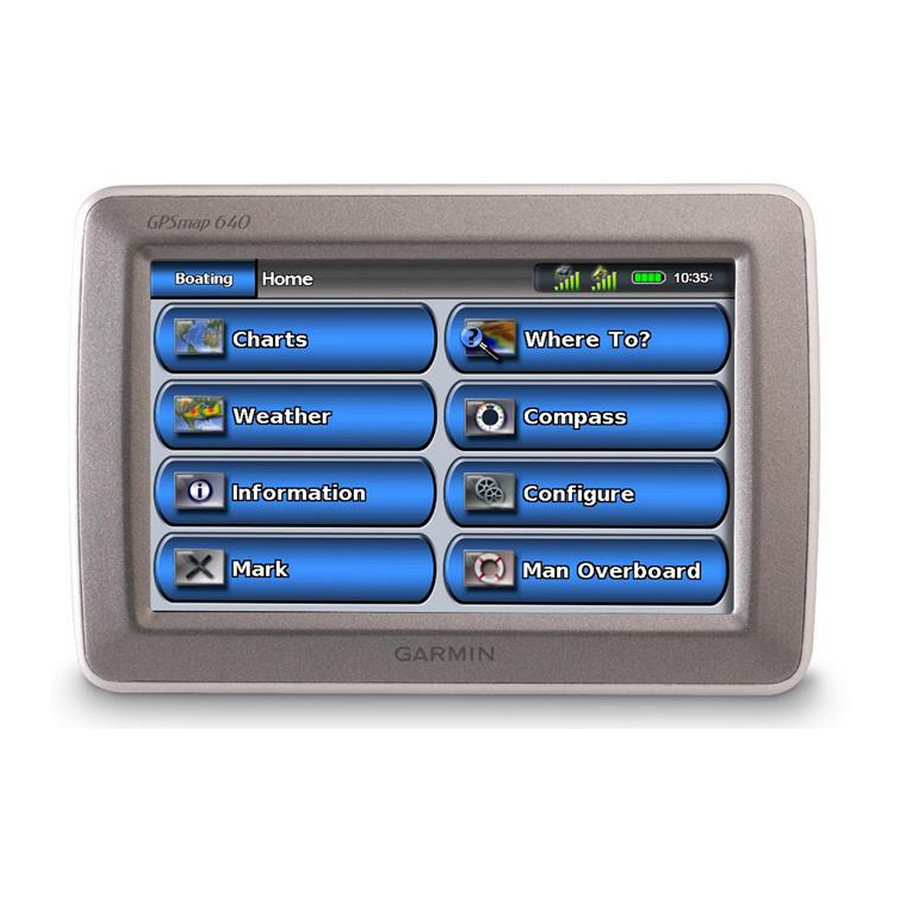
Garmin GPSMAP 640 Manuals
Manuals and User Guides for Garmin GPSMAP 640. We have
8
Garmin GPSMAP 640 manuals available for free PDF download: Owner's Manual, Manual, Declaration Of Conformity, Guía De Consulta Rápida, Quick Reference Manual, Installation Instructions
Garmin GPSMAP 640 Owner's Manual (96 pages)
Garmin Marine and Automotive GPS Navigation System Owner's Manual
Brand:
Garmin
| Category:
GPS
| Size: 2 MB
Table of Contents
Product Registration
3
Contact Garmin
3
Manual Conventions
3
Avoiding Theft
4
Cleaning the Unit
4
Water Immersion
4
Caring for Your GPSMAP 640
4
Table of Contents
5
Getting Started
9
Identifying the GPSMAP 640 Features
9
Identifying the GPSMAP 640 Mounting Bracket Features
9
Using the Mounting Bracket
10
Powering the GPSMAP 640 on and off
11
Removing and Inserting the Battery Pack
11
Inserting and Removing a Secure Digital (SD) Card
12
Marine Mode: Getting Started
13
Step 1: Mount Your GPSMAP 640
13
Step 2: Configure Your GPSMAP 640
13
Step 3: Acquire Satellites
13
Step 4: Use Your GPSMAP 640
13
Navigating Directly to a Destination
14
Saving Your Current Location
14
Navigating Directly to a Saved Location
15
Stopping Navigation
15
Adjusting the Volume
15
Adjusting the Backlight
15
Marine Mode: Using Charts
16
Using the Navigation Chart
16
Interacting with Objects on the Navigation Chart
17
Accessing Additional Object or Chart Information
17
Using Perspective 3D
18
Using Bluechart G2 Vision
19
Using Mariner's Eye 3D
19
Using Fish Eye 3D
20
Using Fishing Charts
20
Enabling High-Resolution Satellite Imagery
20
Marine Mode: Navigating
22
Step 1: Choose a Destination
22
Step 2: Set and Follow the Course
22
Marine Mode: Where to
28
Searching for Marine Services
28
Searching for Waypoints
28
Searching for Saved Routes
28
Searching for Saved Tracks
29
Searching by Name
29
Marine Mode: Using Waypoints and Tracks
30
Using man Overboard (MOB) Waypoints
30
Marking a Waypoint at Your Current Location
30
Creating a Waypoint from the Navigation Chart
30
Editing Waypoint Details
31
Using Tracks
31
Clearing the Active Track
32
Navigating a Saved Track
32
Saving the Active Track
32
Marine Mode: Using the Dashboard
33
Using the Compass Screen
33
Using the Numbers Screen
34
Using the Trip Screen
34
Marine Mode: Viewing Almanac Data
35
Viewing Tide Station Information
35
Viewing Current Information
35
Viewing Celestial Information
36
Marine Mode: Managing User Data
37
Transferring Marine Data (Waypoints, Routes, Tracks) to or from an SD Card
37
Backing up Marine Data to a PC
37
Copying or Merging Mapsource Marine Data to the GPSMAP
38
Marine Mode: Managing Information from Other Vessels
39
Viewing AIS Information
39
Viewing DSC Information
39
Marine Mode: Advanced Configuration
41
Configuring System Settings
41
Changing Units of Measure
42
Configuring Communications Settings
43
Configuring Alarm Settings
44
Configuring My Boat
45
Configuring Other Vessels
45
Configuring Navigation Settings
46
Configuring XM Radio
46
Configuring Navigation Chart Options
47
Configuring Perspective 3D Options and Mariner's Eye 3D Options
51
Fish Eye 3D Settings
52
Fishing Chart Settings
52
Configuring the Active Track Options
53
Configuring the Numbers Screen
54
Marine Mode: Using XM WX Weather and Audio
55
Using XM WX Weather
55
Setting the XM WX Weather Options
55
Viewing Precipitation Information
55
Viewing Forecast Information
57
Viewing Sea Conditions
58
Viewing Fishing Information
59
Viewing Visibility Information
60
Viewing Buoy Reports
60
Using XM Audio
61
Automotive Mode: Getting Started
62
Step 1: Mount Your GPSMAP 640
62
Step 2: Configure Your GPSMAP 640
62
Step 3: Acquire Satellites
62
Step 4: Use Your GPSMAP 640
62
Finding Your Destination
63
Adding a Stop
63
Taking a Detour
63
Stopping the Route
63
Automotive Mode: Where to
64
Finding an Address
64
Setting a Home Location
64
Go! Page Options
65
Finding a Place by Spelling the Name
65
Searching Near Another Location
65
Finding Recently Found Places
65
Favorites
66
Finding a Place Using the Map
66
Using Custom Routes
67
Entering Coordinates
68
Navigating off Road
68
Automotive Mode: Using the Map
69
Next Turn
69
Turn List
69
Trip Computer
70
Automotive Mode: Managing Files
71
Copying Files to the Unit
71
Copying Automotive Data to the Unit Using Mapsource
71
Deleting Automotive Files
72
Automotive Mode: Using the Tools
73
Settings
73
Where am I
73
Picture Viewer
73
My Data
73
Automotive Mode: Advanced Configuration
74
Changing the System Settings
74
Changing the Navigation Settings
74
Adjusting the Display Settings
74
Adjusting the Volume
75
Adjusting the Backlight
75
Updating the Time Settings
75
Setting the Languages
75
Changing the Map Settings
75
Changing Security Settings
76
Restoring All Settings
76
Automotive Mode: Using XM
77
Listening to XM Radio
77
Using XM Traffic Information
78
Traffic in Your Area
78
Severity Color Code
78
Traffic on Your Route
78
Viewing the Traffic Map
79
Viewing Traffic Delays
79
Adding an XM Subscription
79
Appendix
80
Calibrating the Screen
80
Resetting Your GPSMAP 640
80
Updating the Software
80
Clearing User Data
80
Battery Information
80
Charging Your GPSMAP 640
81
Changing the Fuse on the Automotive Mount
81
Additional Maps
81
About GPS Satellite Signals
81
Extras and Optional Accessories
82
Specifications
82
Declaration of Conformity
83
Software License Agreement
83
Troubleshooting
83
Messages and Alarms (Marine Mode)
84
Index
89
Advertisement
Garmin GPSMAP 640 Owner's Manual (84 pages)
Brand:
Garmin
| Category:
Marine GPS System
| Size: 1 MB
Table of Contents
Product Registration
3
Contact Garmin
3
Manual Conventions
3
Table of Contents
4
Getting Started
7
Identifying the GPSMAP 620 and GPSMAP 640 Features
7
Identifying the Mounting Bracket Features
7
Using the Mounting Bracket
8
Powering the Device on and off
9
Removing and Inserting the Battery Pack
9
Inserting and Removing a Secure Digital (SD) Card
10
Marine Mode: Getting Started
11
Step 1: Mount Your GPSMAP 620 or GPSMAP 640
11
Step 2: Configure Your Device
11
Step 3: Acquire Satellites
11
Step 4: Use Your GPSMAP 620 or GPSMAP 640
11
Navigating Directly to a Destination
12
Saving Your Current Location
12
Navigating Directly to a Saved Location
12
Stopping Navigation
13
Adjusting the Volume
13
Adjusting the Backlight
13
Marine Mode: Using Charts
14
Using the Navigation Chart
14
Interacting with Objects on the Navigation Chart
15
Accessing Additional Object or Chart Information
15
Viewing Aerial Photos
16
Using Perspective 3D
16
Using Bluechart G2 Vision
16
Using Mariner's Eye 3D
17
Using Fish Eye 3D
17
Using Fishing Charts
17
Enabling High-Resolution Satellite Imagery
18
Marine Mode: Navigating
19
Step 1: Choose a Destination
19
Step 2: Set and Follow the Course
19
Marine Mode: Where to
25
Searching for Marine Services
25
Searching for Waypoints
25
Searching for Saved Routes
25
Searching for Saved Tracks
26
Searching by Name
26
Marine Mode: Using Waypoints and Tracks
27
Using man Overboard (MOB) Waypoints
27
Marking a Waypoint at Your Current Location
27
Creating a Waypoint from the Navigation Chart
28
Editing Waypoint Details
28
Using Tracks
28
Clearing the Active Track
29
Saving the Active Track
29
Marine Mode: Using the Dashboard
30
Using the Compass Screen
30
Using the Numbers Screen
31
Using the Trip Screen
31
Marine Mode: Viewing Almanac Data
32
Viewing Tide Station Information
32
Viewing Current Information
32
Viewing Celestial Information
33
Marine Mode: Managing User Data
34
Transferring Marine Data (Waypoints, Routes, Tracks) to or from an SD Card
34
Backing up Marine Data to a Computer
34
Copying or Merging Mapsource ® Marine Data to the
35
GPSMAP 620 or GPSMAP
35
Marine Mode: Managing Information from Other Vessels
36
Viewing AIS Information
36
About AIS
36
Viewing DSC Information
40
Viewing the DSC List
40
Navigating to a Vessel in Distress
41
Incoming Distress Calls
41
Position Tracking
42
Marine Mode: Advanced Configuration
44
Configuring System Settings
44
Changing Units of Measure
45
Configuring Communications Settings
46
Configuring Alarm Settings
47
Configuring My Boat
48
Configuring Other Vessels
49
Configuring Navigation Settings
49
Configuring Navigation Chart Options
51
Configuring Perspective 3D Options and Mariner's Eye 3D Options
56
Fish Eye 3D Settings
57
Fishing Chart Settings
57
Configuring the Active Track Options
58
Configuring the Numbers Screen
58
Automotive Mode: Getting Started
59
Step 1: Mount Your GPSMAP 620 or GPSMAP
59
Step 2: Configure Your Device
59
Step 3: Acquire Satellites
59
Step 4: Use Your Device
59
Finding Your Destination
60
Adding a Stop
60
Taking a Detour
60
Stopping the Route
60
Automotive Mode: Where to
61
Finding an Address
61
Setting a Home Location
61
Go! Page Options
62
Finding a Place by Spelling the Name
62
Searching Near Another Location
62
Finding Recently Found Places
62
Favorites
63
Finding a Place Using the Map
64
Using Custom Routes
64
Creating a Custom Route
64
Editing Custom Routes
65
Entering Coordinates
65
Navigating off Road
65
Automotive Mode: Using the Map
66
Next Turn
66
Turn List
66
Trip Computer
67
Resetting the Trip Computer
67
Automotive Mode: Managing Files
68
Copying Files to the Unit
68
Copying Automotive Data to the Unit Using Mapsource
69
Deleting Automotive Files
69
Automotive Mode: Using the Tools
70
Settings
70
Where am I
70
Picture Viewer
70
My Data
70
Automotive Mode: Advanced Configuration
71
Changing the System Settings
71
Changing the Navigation Settings
71
Adjusting the Display Settings
71
Adjusting the Volume
72
Adjusting the Backlight
72
Updating the Time Settings
72
Setting the Languages
72
Changing the Map Settings
73
Changing Security Settings
73
Restoring All Settings
73
Appendix
74
Calibrating the Screen
74
Resetting Your GPSMAP 620 or GPSMAP
74
Updating the Software
74
Clearing User Data
74
Battery Information
74
Charging Your GPSMAP 620 or GPSMAP
75
Changing the Fuse on the Automotive Mount
75
Caring for the Unit
75
Additional Maps
76
About GPS Satellite Signals
76
Extras and Optional Accessories
76
Specifications
77
Declaration of Conformity
77
Software License Agreement
77
Troubleshooting
78
Messages and Alarms (Marine Mode)
79
Index
80
Garmin GPSMAP 640 Manual (24 pages)
Weather and XM Satellite Radio Supplement
Brand:
Garmin
| Category:
Marine GPS System
| Size: 0 MB
Table of Contents
Simulator Mode
3
Contact Garmin
3
Table of Contents
4
Marine Mode: Using XM WX Weather and Audio
5
XM WX Satellite Weather
5
Weather Data Broadcasts
5
Viewing Precipitation Information
5
Changing from One Weather Chart to a Different Weather Chart
5
Storm Cell and Lightning Information
6
Hurricane Information
6
Weather Warnings and Weather Bulletins
7
Forecast Information
7
Viewing Sea Conditions
9
Viewing Fishing Information
10
Visibility Information
11
Viewing Buoy Reports
12
Viewing Local Weather Information
12
Creating a Waypoint on the Forecast Screen
12
About the Weather Overlay
13
Weather Alarms
14
Viewing Weather Subscription Information
15
XM Satellite Radio
16
Using XM Radio
16
Automotive Mode: Using XM
17
Listening to XM Radio
17
Using XM Traffic Information
18
Traffic in Your Area
18
Severity Color Code
18
Traffic on Your Route
18
Viewing the Traffic Map
19
Viewing Traffic Delays
19
Adding an XM Subscription
19
20
Appendix
20
Weather Data Warranty
20
Software License Agreement
21
XM Satellite Radio Service Agreement
22
Index
23
Advertisement
Garmin GPSMAP 640 Declaration Of Conformity (6 pages)
Marine navigation equipment
Brand:
Garmin
| Category:
Marine GPS System
| Size: 0 MB
Table of Contents
Declaration of Conformity
1
Declaration de Conformite
2
Dichiarazione DI Conformità
3
Declaración de Conformidad
5
Declaração de Conformidade
6
Garmin GPSMAP 640 Installation Instructions (2 pages)
Marine Mount
Brand:
Garmin
| Category:
GPS
| Size: 0 MB
Table of Contents
Step 1: Select a Location for the GPSMAP 620/640 Marine Mount
1
Step 3: Connect the GPSMAP 620/640 Marine-Mount Bracket to Power
2
Optional: Connecting to a NMEA 0183 Device
2
Optional: Connecting to an External Audio Device
2
Garmin GPSMAP 640 Quick Reference Manual (2 pages)
Garmin GPSMAP 620: Quick Start
Brand:
Garmin
| Category:
GPS
| Size: 0 MB
(Spanish) Garmin GPSMAP 640 Guía De Consulta Rápida (2 pages)
Garmin GPS Receiver User Manual
Brand:
Garmin
| Category:
GPS
| Size: 1 MB
(Italian) Garmin GPSMAP 640 Quick Reference Manual (2 pages)
Garmin GPS Receiver User Manual
Brand:
Garmin
| Category:
GPS
| Size: 0 MB
Advertisement
Related Products
Garmin GPSMAP 64
Garmin GPSMAP 64s
Garmin GPSMAP 64sc SiteSurvey
Garmin GPSMAP 64X Series
Garmin GPSMAP 64SX
Garmin nuvi 660FM Guide
Garmin GPSMAP 696
Garmin FORETREX 601
Garmin GPSMAP 66s
Garmin GPSMAP 66st
Garmin Categories
GPS
Watch
Car Navigation system
Avionics Display
Marine Equipment
More Garmin Manuals
Login
Sign In
OR
Sign in with Facebook
Sign in with Google
Upload manual
Upload from disk
Upload from URL