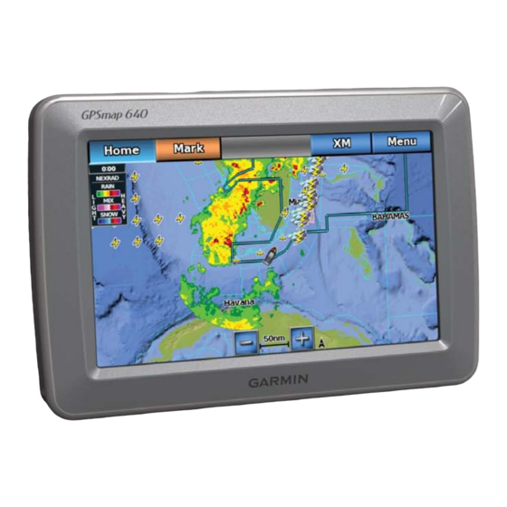
Garmin GPSMAP 640 Manual
Weather and xm satellite radio supplement
Hide thumbs
Also See for GPSMAP 640:
- Owner's manual (96 pages) ,
- Quick reference manual (2 pages) ,
- Declaration of conformity (6 pages)
Table of Contents
Advertisement
Quick Links
Advertisement
Table of Contents

Related Manuals for Garmin GPSMAP 640


Summary of Contents for Garmin GPSMAP 640
- Page 1 GPSMAP ® Weather and XM Satellite Radio Supplement...
- Page 2 All rights reserved. Except as expressly provided herein, no part of this manual may be reproduced, copied, transmitted, disseminated, downloaded or stored in any storage medium, for any purpose without the express prior written consent of Garmin. Garmin hereby grants permission to download a single copy of this manual onto a hard drive or other electronic storage medium to be viewed and to print one copy of this manual or of any revision hereto, provided that such electronic or printed copy of this manual must contain the complete text of this copyright notice and provided further that any unauthorized commercial distribution of this manual or any revision hereto is strictly prohibited.
-
Page 3: Simulator Mode
Garmin USA by phone at (913) 397.8200 or (800) 800.1020. See the Important Safety and Product Information guide in the product In the UK, contact Garmin (Europe) Ltd. by phone at 0808 2380000. box for product warnings and other important information. -
Page 4: Table Of Contents
Equipment Requirements: XM............i Using XM Traffic Information ............14 Simulator Mode .................i Traffic in Your Area .................14 Contact Garmin ................i Severity Color Code ...............14 Marine Mode: Using XM WX Weather and audio ....1 Traffic on Your Route ..............14 XM WX Satellite Weather ..............1... -
Page 5: Marine Mode: Using Xm Wx Weather And Audio
Viewing Precipitation information To use XM WX Satellite Weather on your GPSMAP 640, you must connect a Garmin GXM 40 XM antenna and activate an XM WX weather The Precipitation screen shows radar weather, storm cells, lighting strikes, subscription. -
Page 6: Storm Cell And Lightning Information
Marine Mode: Using XM WX Weather and Audio 3. Select Menu > Change Weather. Hurricane information 4. Select a different weather chart. The Precipitation screen can show the present position of a hurricane ➊ a tropical storm, or a tropical depression. A red line stemming from a Storm Cell and Lightning information hurricane icon indicates the projected path of the hurricane. -
Page 7: Weather Warnings And Weather Bulletins
Marine Mode: Using XM WX Weather and Audio Weather Warnings and Weather Bulletins Forecast information When a marine weather warning or weather bulletin is issued, shading The Forecast screen shows weather conditions, including fronts, pressure indicates the area to which the warning or bulletin applies. To view centers, sea surface pressure, and city forecasts. - Page 8 Marine Mode: Using XM WX Weather and Audio Weather Fronts and Pressure Centers: Surface analysis City Forecasts Weather Maps City forecasts appear as weather symbols as defined by the Weather ➊ Weather fronts appear as lines that indicate the leading edge of an air Symbol Table.
-
Page 9: Viewing Sea Conditions
Marine Mode: Using XM WX Weather and Audio 5 knots 50 knots Symbol Weather Symbol Weather Thunderstorms Snow (snow showers, flurries, 10 knots 65 knots blizzard, blowing snow, sleet, freezing rain, freezing drizzle) 15 knots Foggy Smoke (dusty, hazy) Wave Height, Wave Period, and Wave Direction Wave heights for an area appear as variations in color. -
Page 10: Viewing Fishing Information
Marine Mode: Using XM WX Weather and Audio Viewing Forecast Sea Conditions information for another Surface Pressure and Water Temperature Data Time Period Surface-pressure information appears using pressure isobars and pressure 1. From the Home screen, select Weather > Sea Conditions. centers. -
Page 11: Visibility Information
Marine Mode: Using XM WX Weather and Audio Visibility information Forecasting Fish Location You can show areas that contain optimal weather conditions for specific Visibility is the forecast maximum horizontal distance that can be seen at species of fish. the surface, as shown in the legend on the left of the screen. -
Page 12: Viewing Buoy Reports
Marine Mode: Using XM WX Weather and Audio • Select Previous Forecast to view the forecast visibility for the 4. Complete an action: previous 12 hours, and select Previous Forecast again to view • Select Current Cond. to view present weather conditions from a forecasts for the previous 24 and 36 hours, in 12-hour increments. -
Page 13: About The Weather Overlay
Marine Mode: Using XM WX Weather and Audio about the Weather Overlay Showing WX radar Precipitation Data on a Chart WX Radar shows very light rain and snow up to strong thunderstorms in The weather overlay superimposes weather and weather-related varying shades and colors. -
Page 14: Weather Alarms
Marine Mode: Using XM WX Weather and Audio 3. Select Menu. Showing Fish Forecasting Data on the Fishing Chart Before you can show fish forecasting data on the Fishing chart, you must 4. Select Navigation Chart Setup or Fishing Chart Setup turn on the weather overlay (page 5. -
Page 15: Viewing Weather Subscription Information
To use XM Satellite Radio features, you must have a Garmin XM Satellite a Garmin GXM 40 XM antenna, you can view information about the radio receiver connected to your GPSMAP 640 and to the audio input of weather services you have subscribed to and how many minutes have your boat. -
Page 16: Xm Satellite Radio
Marine Mode: Using XM WX Weather and Audio XM Presets The XM presets list is a customizable channel category. You can save your favorite channels to the presets list. Saving an XM Channel to the Presets List 1. From the Home screen, select Configure > XM Audio. 2. -
Page 17: Automotive Mode: Using Xm
Your GPSMAP 640 can receive XM radio, XM weather, and XM 2. Touch tools > XM Services > XM Radio to open the XM Radio traffic using an optional XM antenna (such as the Garmin GXM 40 XM player. antenna). For more information about an XM smart antenna and XM subscriptions, visit www.garmin.com/xm. -
Page 18: Using Xm Traffic Information
GPSMAP 640. stopped. Traffic Note: You can only access the traffic information if the GPSMAP 640 is Receiving Gray information is connected to an XM antenna (such as the GXM 40 XM antenna) and you information being received. -
Page 19: Viewing The Traffic Map
3. Touch the arrows to view other traffic delays on your route, if 5. Follow the on-screen instructions. necessary. Note: Additional documentation is provided with your Garmin XM 4. Touch Avoid to avoid the traffic delay. antenna. Viewing the Traffic Map... -
Page 20: Appendix
This NEGLIGENCE OR OTHERWISE. OUR TOTAL LIABILITY TO information is provided “as is” and XM and Garmin disclaim any and all YOU AND ANY OTHER PERSONS RECEIVING OUR SERVICES, warranties, express and implied, with respect thereto or the transmission REGARDLESS OF THE CAUSE, WILL IN NO EVENT EXCEED or reception thereof. -
Page 21: Software License Agreement
Garmin and/or its third-party providers and that the Software in source c. Neither NGA nor its personnel will be liable for any claims, losses, or code form remains a valuable trade secret of Garmin and/or its third- damages arising from or connected with the use of this product. The user party providers. -
Page 22: Xm Satellite Radio Service Agreement
Appendix XM Satellite radio Service agreement XM Satellite Radio Inc. Hardware and required monthly subscription sold separately. Subscription fee is consumer only. Other fees and taxes, including a one-time activation fee apply. All programming fees and weather data subject to change. XM WX weather data displays and individual product availability vary by hardware equipment. -
Page 23: Index
Index index forecasts pressure centers volume 12, city pressure, surface fish previous forecast 3, 6, warnings, weather future alarms warranty, weather data marine flash flood radio receiver water temperature offshore flood radio, XM satellite wave past marine automotive direction present severe storm marine height... - Page 24 For the latest free software updates (excluding map data) throughout the life of your garmin products, visit the garmin Web site at www.garmin.com. © 2011 Garmin Ltd. or its subsidiaries Garmin International, Inc. 1200 East 151 Street, Olathe, Kansas 66062, USA Garmin (Europe) Ltd.
Need help?
Do you have a question about the GPSMAP 640 and is the answer not in the manual?
Questions and answers