Garmin StreetPilot GPS Owner's Manual And Reference Manual
Hide thumbs
Also See for StreetPilot GPS:
- Reference manual (88 pages) ,
- Owner's manual (88 pages) ,
- Specifications (2 pages)

Subscribe to Our Youtube Channel
Related Manuals for Garmin StreetPilot GPS


Summary of Contents for Garmin StreetPilot GPS
- Page 1 O O w w n n e e r r ’ ’ s s M M a a n n u u a a l l Reference Guide Map detail shown is with optional MetroGuide cartridge inserted...
- Page 2 Information in this document is subject to change without notice. GARMIN reserves the right to change or improve its products and to make changes to the content without obligation to notify any person or organization of such changes. Visit the GARMIN website for current updates and supplemental information concerning the use and operation of this and other GARMIN products.
- Page 3 Reference provides details about the complete feature setup of the StreetPilot by topic. Before getting started with your GPS, check to see that your GARMIN StreetPilot package includes the following items. If you are missing any parts, please contact your GARMIN dealer immediately.
- Page 4 StreetPilot over airbag panels or in a place where the driver or passengers are likely to have an impact with it in an accident or collision. The mounting hardware provided by GARMIN is not warranted against collision damages or the consequences thereof. Ù...
-
Page 5: Map Data
Point of interest information (businesses, attractions, etc.) is extensive but not complete, and good position accuracy is not always available from our data providers. GARMIN does not make any warranty, express or implied, as to the completeness or accuracy of the data included in this product. - Page 6 You further acknowledge that the structure, organization and code of the Software are valuable trade secrets of GARMIN and that the Software in source code form remains a valuable trade secret of GARMIN. You agree not to decompile, disassemble, modify, reverse assemble, reverse engi- neer or reduce to human readable form the Software or any part thereof or create any derivative works based on the Software.
- Page 7 F F C C C C C C o o m m p p l l i i a a n n c c e e The GARMIN StreetPilot ‘ColorMap’ has been tested to comply with FCC Standards for home and office use. It complies with Part 15 of the Federal Communications Commission (FCC) limits for Class B digital devices.
- Page 8 GARMIN Corporation warrants this product to be free from defects in materials and workmanship for one year from the date of purchase. GARMIN will, at its sole option, repair or replace any components that fail in normal use. Such repairs or replacement will be made at no charge to the customer for parts or labor. The customer is, how- ever, responsible for any transportation costs.
-
Page 9: Table Of Contents
introduction T T a a b b l l e e o o f f C C o o n n t t e e n n t t s s REFERENCE INTRODUCTION Find Functions ......39 Finding a City . -
Page 10: Introduction
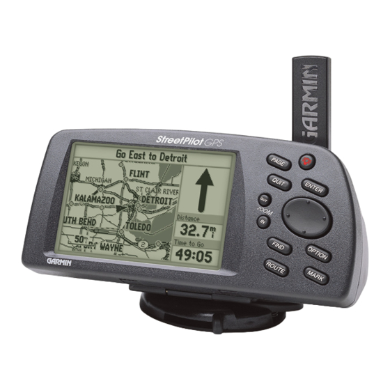
introduction S S t t r r e e e e t t P P i i l l o o t t U U n n i i t t Antenna LCD Display Rotate upright for best 16 Color DSTN LCD satellite reception. -
Page 11: Cautions
Battery/MetroGuide Cartridge Installation The StreetPilot operates on six (6) AA batteries which Note: are installed from the left end of the unit, when viewed from the front. Alkaline, rechargeable NiCad, or lithium The on-screen battery quick-start batteries may be used. For extended operation, use the ciga- level indicator may be calibrat- rette lighter adapter to conserve batteries. -
Page 12: Keypad
Keypad Turns the unit on and off. A momentary press while the power is on activates the backlight/contrast adjustment window. Press and hold to turn the StreetPilot off. quick-start Changes between the main pages and returns display from an option window back to a main page. -
Page 13: Turning The Streetpilot On And Off
T urning the StreetPilot On and Off To turn the StreetPilot on: quick-start T T u u r r n n i i n n g g t t h h e e U U n n i i t t O O n n a a n n d d O O f f f f Now that you know how to turn the StreetPilot on, it might be helpful to know just Welcome Page how to turn it off! -
Page 14: Adjusting Screen Brightness/Contrast
Adjusting Screen Brightness and Contrast The StreetPilot screen lighting may be set to a variety of levels for different lighting conditions and personal preferences. When driving toward the sun, it may be helpful to increase the screen brightness for more comfortable viewing. You will want to decrease quick-start the brightness when driving at night or switch to ‘Night Mode’. -
Page 15: Dash Mounting And External Power
Dashboard Mounting and External Power Your StreetPilot is designed with portability in mind--allowing you to easily trans- port the unit from one vehicle to another or take it with you once you reach your desti- nation. A dash mount is included in the StreetPilot package, providing a semi-perma- quick-start nent method of installing the unit at the best viewing location for the driver or passen- ger(s) . -
Page 16: Finding Your Location The First Time
Finding Your Location the First Time The first time you use your new StreetPilot to navigate, take it outside or properly mount it on the dashboard of a vehicle in an open area that has a clear view of the sky. Either way, make sure the antenna is pointing up. -
Page 17: Main Page Sequence
Main Page Sequence The StreetPilot features two main pages, the Map Page and the Dashboard Page. Press P or Q to switch back and forth between the two main pages. quick-start If the StreetPilot is navigating to a destination, there is a third page called the Road Sign Page. -
Page 18: Map Zooming And Panning
Map Zooming and Panning Once the StreetPilot calculates your location, you may find it enjoyable just to view the Map Page and watch your movement along roads and streets. There will be plenty of time later to learn about the ‘Find’ and ‘Route’ functions, but let’s keep it simple for quick-start now. -
Page 19: The Trip Computer
The T rip Computer Now, try taking a look at the Trip Computer by pressing P until you see the steer- ing wheel and dashboard (see top right picture). This page shows your speed, an odometer and a variety of other valuable information. See page 24 for more information. quick-start The O Key The StreetPilot has an O key which you may press at any time to see a menu of... -
Page 20: Making Keypad Entries
Making Keypad Entries Changing between pages and zooming the map in and out are fun for a while, but sooner or later you’ll be ready for new challenges, and you will have the occasion to enter some information using the keypad. quick-start There are street addresses, points of interest, and city names to find;... - Page 21 Next, let’s “Mark” a Personal Waypoint at the StreetPilot’s current location and give it a name to give you an idea how to make a character entry. Making a character entry to name a Personal W aypoint: quick-start M M a a k k i i n n g g K K e e y y p p a a d d E E n n t t r r i i e e s s Power User Tip If you wish to clear the entire entry, press the <...
-
Page 22: Find And Goto
Find and Goto Let’s say you’re driving along in Denver, Colorado looking at the Map Page. You’re on your way to an appointment or meeting in Castle Rock and you’d like to know what direction to go, how far it is, and about how long it will take to drive there. quick-start To find and go to a location: F F i i n n d d a a n n d d G G o o t t o o... -
Page 23: Reference
If the StreetPilot GPS has yet to calculate your location, there is a flashing question mark (?) over the vehicle pointer and the status line at the top of the page says ‘Acquiring Satellites. -
Page 24: Zooming
If you are driving along a road which is shown on the map, the vehicle pointer will often be shown moving right down the road. This occurs when your location and the direction you are driving indicate that you are probably on that street. While the StreetPilot does its best to show you on the correct street, there are times when the Map reference Page may momentarily show you on one street, and you are actually driving on another,... -
Page 25: Driving Status
Note: Driving Status The information displayed The top of the Map Page shows your Driving Status: for the Driving Status and • The direction you are driving, one of eight possible directions--North (N), the Navigation Info window changes if the StreetPilot is navigating to a South (S), East (E), West (W), NE, SE, SW or NW. -
Page 26: Panning
Panning Another feature of the Map Page is the pan function, which allows you to point at and identify features on the map, and to move the map in order to view areas beyond the current map area. To activate the pan function: Arrow Pointer Panning reference M M a a p p P P a a n n n n i i n n g g... - Page 27 It is very possible that you may see area or features on the map that you might like to go to. For example, you can pan to a city, road, lake or river, and create a Personal Waypoint there. It’s also possible to get directional guidance there once it has been created. To create a Personal W aypoint on the Map: Displaying a Map Object reference...
-
Page 28: Map Page Options
To go to a highlighted Personal W aypoint: Go to it Going To a Personal Waypoint To cancel the pan function and re-center the map on your location: reference Map Page Options To display the Map Page options: M M a a p p P P a a g g e e O O p p t t i i o o n n s s Show Map Full Screen or Show Map and Nav Info To enable a larger map display, select Show Map Full Screen, which removes the Driving Status and the other information that... - Page 29 Customize Map Allows you to set a variety of options that select what is displayed on the Map Page, as well as how it is displayed. We’ll get into the details in just a moment. Measure Distance Allows you to compute the distance between any two points you select on the Map Page, whereas regular map panning only allows you to see the distance and direction from your current location to Measuring Distance...
-
Page 30: Customizing The Map Page
Stop Navigation If the StreetPilot is navigating to a destination, and you wish to dis- continue navigation because you have reached that destination or no longer need guidance to get there, highlight this field and press ‘Customize Map’ Screen Customizing the Map Page When you select Customize Map from the Map Page options, a page is displayed with three file tabs, ‘General Settings’, ‘Points’, and ‘Vehicle’... - Page 31 Orientation Lets you set the orientation of map display. May be North Up or Track Up. The advantage of North Up is that it looks just like paper maps. The advantage of Track Up is that the picture on the screen is a representation of what you see out the windshield.
- Page 32 ‘Points’ File Tab (see bottom left picture) Power User Tip W aypoints Lets you set which map scales (if any) show Personal Waypoints. The StreetPilot shows latitude and longitude in degrees, minutes, and Points of Interest Lets you set which map scales (if thousandths of minutes using any) show Points of Interest, such the WGS-84 map datum.
- Page 33 To modify the display of Points of Interest: Excluding Points from the Map Display reference ‘Vehicle’ File Tab (see bottom right picture) C C u u s s t t o o m m i i z z i i n n g g t t h h e e M M a a p p Vehicle Icon Lets you view your vehicle as an Indy Car or an Arrow.
-
Page 34: The Dashboard Page
The Dashboard Page To see the Dashboard Page, press the P key until you see the page which resem- bles an automobile dashboard with a steering wheel. The Dashboard Page has two dif- ferent views, the Trip Computer view and the Satellite Status view. The first time you look at this page, it will probably be showing the Trip Computer (see top left picture). -
Page 35: Trip Computer
Although the StreetPilot doesn’t know anything about your fuel tank, headlights, Note: or engine, its “dashboard” can display the battery level and how well the GPS receiver The driving status shown “engine” is running. on the Dashboard Page displays driving direction (as well The Dashboard Page shows the Driving Status across the top of the screen like the as a street and nearby city in some Map Page does (see page 15). - Page 36 Speed (Shown at the top of the dashboard area) The current speed at which you are traveling. Odometer (Shown in a box, just below the speed) A running total of distance traveled, based upon the distance between second-by-second loca- tion readings, since the Trip Computer was last reset. Power/Battery (Shown just to the left of the odometer) If the StreetPilot is using its internal AA batteries, a battery symbol (b) is shown.
- Page 37 ary) during the time the StreetPilot has been tracking your loca- tion, since the Trip Computer was last reset. Total Time The total length of time for which the StreetPilot has been tracking your location, since the Trip Computer was last reset. This is always equal to Driving Time plus Stopped Time.
-
Page 38: Satellite Status
Satellite Status View The Satellite Status view of the Dashboard Page shows you status information that helps you understand what the GPS receiver is doing at any given time, and it’s a page that you’ll want to occasionally refer back to as you use your StreetPilot. It features a sky view of available satellites, number of satellites, and your current accuracy. - Page 39 If you have moved the StreetPilot several hundred miles since the last time it navigat- ed using satellite signals, you may find that the StreetPilot will calculate your location more quickly if you set the approximate initial location. To set the initial location: Setting the Initial Location Set Initial Location reference...
-
Page 40: System Setup
System Setup The System Setup Pages (see top left picture) can be accessed in two ways. All option menus include System Setup as a choice. In addition, at any time you may press the O key twice in a row to display the System Setup. This is a group of pages to perform various System Setup functions, including configuring the display and backlighting, units of measure, and setting various alarms. - Page 41 To restore the factory settings: Restore Factory Settings Restoring Factory Settings reference The file tab headings and System Setup functions are: S S y y s s t t e e m m S S e e t t u u p p General: Simulator, Night Mode, Battery Type, Beeper, and Distance Units.
-
Page 42: General' File Tab
‘General’ File Tab (see top left picture) Simulator Lets you operate the StreetPilot indoors to plan trips and find loca- tions when the unit is unable to receive GPS satellite signals. May be set to Off or On. The Simulator Mode is especially useful if you are indoors and wish to try out the StreetPilot features. -
Page 43: Alarms' File Tab
‘Alarms’ File Tab (see top right picture) Approaching W aypoint Alarm Provides an alarm message once you’re within a set time (choices range from 15 seconds to five minutes) from your turn or destina- tion waypoint. As you approach the waypoint, a message occurs when your estimated arrival time is within the alarm time you entered. -
Page 44: Time' File Tab
Time Format Allows the current time to be displayed using a 12- or 24-hour clock. Daylight Savings Time Lets you determine whether Daylight Savings Time (DST) is used or not. Auto adjusts for DST based on what day of the year it is. Yes and No allow DST to manually be enabled or disabled (for geo- ‘Time’... -
Page 45: Comm Port' File Tab
“ “ C C o o m m m m P P o o r r t t ” ” F F i i l l e e T T a a b b • GARMIN Data Transfer—the proprietary format used to exchange waypoint, route, and track log data with a PC or with another StreetPilot. - Page 46 To select a serial data format: GARMIN T ransfer Mode List Host reference RTCM ‘ ‘ C C o o m m m m P P o o r r t t ’ ’ F F i i l l e e T T a a b b Selecting an RTCM Format Ù...
-
Page 47: Waypoint
Marking Your Location as a Personal Waypoint It is often very useful to mark a location, so that you can drive to it again later. These locations are called ‘Personal Waypoints’. The StreetPilot can hold up to 100 Personal Waypoints. To mark your location as a Personal W aypoint: Marking a Personal Waypoint reference... - Page 48 To change the Personal W aypoint symbol: Waypoint Symbol Page reference Go to it M M a a r r k k i i n n g g Y Y o o u u r r L L o o c c a a t t i i o o n n The ‘Mark Personal Waypoint’...
-
Page 49: Find Functions
Find Functions You can search for Personal Waypoints, Cities or Exits that are included in the StreetPilot basemap. In addition, if you are using an optional MetroGuide cartridge, you can search for and find Points of Interest, Addresses, or Intersections. Highlighting Cities Using the StreetPilot Find Function to Find a City To illustrate the procedure for finding items with the StreetPilot, we’ll use the exam-... - Page 50 Note: To find a City by Name: Large cities (several hundred thousand or more people) are shown as Find by Name large circles. Medium-popula- tion cities are shown as small circles. Small cities (a few Finding a City by Name thousand people or less) are shown as dots.
- Page 51 To find a City using the Last Used list: Last Used List E, they Last Used List reference To view City information: F F i i n n d d i i n n g g a a C C i i t t y y Go to it Point to it...
-
Page 52: Finding A Personal Waypoint
Finding a Personal W aypoint Finding a Personal Waypoint is very similar to finding a City (see page 39). When you select Find Personal Waypoints, you may search for them using the ‘Nearest’, ‘by Name’ or ‘Recently Used’ list. If you have yet to create any Personal Waypoints, there may not be any entries in the ‘Nearest’... -
Page 53: Deleting Personal Waypoints
To delete Personal W aypoints: Deleting a Waypoint Delete Waypoint Delete by reference Symbol Deletion Prompt Delete All Waypoints D D e e l l e e t t i i n n g g P P e e r r s s o o n n a a l l W W a a y y p p o o i i n n t t s s Finding Interstate Exits Note: Exits will not be displayed... -
Page 54: Finding A Point Of Interest
Finding a Point of Interest (within MetroGuide cartridge coverage area ) Finding a Point of Interest is also very similar to finding a City (see page 39). When you select Find Points of Interest, you will see a box with the six major categories. Use the K keypad to select the major category (see top left picture) and press E. - Page 55 To view Point of Interest information: List of Names reference F F i i n n d d i i n n g g a a P P o o i i n n t t o o f f I I n n t t e e r r e e s s t t Information Point of Interest Information Page...
-
Page 56: Finding An Address
Finding an Address (within MetroGuide cartridge coverage area ) The procedure for finding Addresses and Intersections is a little different than Personal Waypoints, Cities, or Points of Interest. To find an address, you enter a Number and a Street. Optionally, you can also enter a City and Zip Code to narrow down the search a little bit. - Page 57 Note: Streets are searched according to their “base names”. For example, ‘Hwy 10’, ‘I-10’, ‘SW 10th St’, and ‘Co Rd 10’ would all be Entering the Street Name found by entering 10. > reference F F i i n n d d i i n n g g a a n n A A d d d d r r e e s s s s Identifying the Street Selecting the Desired Street Leave it Blank...
- Page 58 Change City Note: Steps 11 and 12 are optional. They may be useful in reducing the number addresses found by the search. Highlighting a City Leave it Blank Change Zip Code reference Search F F i i n n d d i i n n g g a a n n A A d d d d r r e e s s s s Note: The location shown on the map for an address Best Search Matches Displayed...
-
Page 59: Finding An Intersection
Finding an Intersection (within MetroGuide cartridge coverage area ) Finding an Intersection is similar to finding an Address (see page 46), with the exception that you enter two streets. To find an Intersection: Searching for an Intersection Search reference No Matching Intersections Found F F i i n n d d i i n n g g a a n n I I n n t t e e r r s s e e c c t t i i o o n n Intersection Highlighted... -
Page 60: Driving On A Direct Goto
Driving on a Direct Goto Once you use the F key to find someplace that you’d like to go, one of the things you can do is select Go to it to select it as a destination and the StreetPilot will help guide you to it. - Page 61 The Road Sign Page on a Direct Goto The other major difference when the StreetPilot is navigating on a Direct Goto is that a new page called the Road Sign Page (see top right picture) is displayed between the Map Page and the Dashboard Page. •...
-
Page 62: Routes
Routes Although the StreetPilot does not automatically give turn-by-turn directions when a destination is chosen, you can select your starting point and your destination and then manually select a route by choosing the roads and streets you wish to travel. After you have “built a route”... - Page 63 Finding the Destination Route Distance Displayed (Point to Point) reference Note: In order for the C C r r e e a a t t i i n n g g a a R R o o u u t t e e route to follow roads, it is necessary to select all intermediate turns,...
-
Page 64: Editing An Existing Route
Start Navigation New Route Created Box Edit reference Note: As you are creating and editing routes, To edit an existing route: E E d d i i t t i i n n g g a a n n E E x x i i s s t t i i n n g g R R o o u u t t e e the top of the screen prompts you for what to do next (see bottom right picture). - Page 65 Review Remove Move Next Inserting a new turn reference C C r r e e a a t t i i n n g g a a R R o o u u t t e e Viewing or editing a turn Start Navigation Power User Tip If after changing the route...
-
Page 66: Deleting A Route
To select an existing route for navigation: Start Navigation Selecting Route Direction reference To stop route navigation: S S e e l l e e c c t t i i n n g g , , D D e e l l e e t t i i n n g g a a R R o o u u t t e e Stop Navigation To delete a route: Delete Route... -
Page 67: Copying A Route
There may be times when you would like to create a route that is similar to one that already exists. For example, there may be more than one way for you to get from “Point A” to “Point B”. To do this, you would copy the route, and then move or add intermediate turns. -
Page 68: Driving On A Route
Driving on a Route Once you have created a route and have selected Start Navigation, the StreetPilot will give you progressive guidance. Just as on a Direct Goto, the Map Page and the Road Sign Page are the two primary sources of this guidance. The Map Page on a Route The Map Page on a route •... - Page 69 Power User Tip You can review route (or Direct Goto) waypoints by panning to them on the Map Page with the K keypad and pressing E. The Road Sign Page on a Route When the StreetPilot is navigating on a Route, the Road Sign Page may be displayed, just as was described on page 50 for a Direct Goto.
- Page 70 Note: To display only one route turn at time: You can change back by using a similar procedure and selecting Show More Turns. Show One Turn Displaying One Route Turn reference As you complete turns on the route, they change from bold to faint on the Road Sign Page (see picture at right).
-
Page 71: Frequently Asked Questions
Yes. How accurate is a GARMIN GPS? F F r r e e q q u u e e n n t t l l y y A A s s k k e e d d Q Q u u e e s s t t i i o o n n s s The StreetPilot is accurate to within 100 meters under the DoD-imposed Selective Availability (S/A). - Page 72 Do I need an additional antenna? In most cases, an additional remote antenna is not necessary due to our powerful 12 parallel channel receiver. However, the StreetPilot needs a direct view of the sky, so for applications in which the view of the sky is obstructed from the StreetPilot an optional remote antenna may be necessary (see Appendix B).
- Page 73 Is there a MetroGuide cartridge for every city? By sending in the availability postcard to GARMIN, you will receive an informa- tion packet showing map coverage for each available cartridge. appendix a Why can’t I find a specific address I’m looking for?
- Page 74 Can I order directly from GARMIN? GARMIN sells units only through GARMIN dealers. You can find the dealer near- est to you with our dealer locator on our internet website www.garmin.com. We sell accessories direct at the suggested list price. Accessories can be ordered using a credit card by calling 1-800-800-1020 toll free.
-
Page 75: Gps Satellite Reception
Appendix B--GPS Satellite Reception The Global Positioning System (GPS) is a system of 24 satellites that circle the Earth twice a day in a very precise orbit and transmit information to Earth. The StreetPilot must continuously receive signals from at least three of these satellites to calculate your location and track your movement. - Page 76 If the StreetPilot is unable to calculate your location after a few minutes: Start Simulator Poor Satellite Reception Box Set New Location Continue Acquiring Set New Location appendix b G G P P S S S S a a t t e e l l l l i i t t e e R R e e c c e e p p t t i i o o n n Use Map AutoLocate Using the Map to Set Location...
- Page 77 Use Map Remote Antenna Mounting The StreetPilot’s antenna may be removed to allow remote-mounting of either the Choosing ‘Use Map’ standard antenna or an optional amplified antenna. In some applications, remote- mounting an antenna will dramatically increase the number of satellites received. If satellite reception is limited in your particular application, you may want to consider one of the following options: Remote Suction Cup Mount--allows you to mount the standard detachable anten-...
-
Page 78: Specifications
Appendix C--Specifications The StreetPilot is constructed of high-quality materials and should not require user maintenance. If your unit ever needs repair, please take it to an authorized GARMIN service center. The StreetPilot has no user-serviceable parts. Never attempt any repairs yourself. - Page 79 Position Accuracy: 1-5 meters (3-15 ft) with DGPS corrections* 15 meters (49 ft) RMS** Velocity Accuracy: 0.1 mph RMS steady state Dynamics: Performs to specifications to 6 g’s Interfaces: NMEA 0183, RTCM (for DGPS corrections) and RS-232 for PC interface Memory Back Up: Internal Lithium Battery, lasts up to 10 years POWER Input:...
- Page 80 Differential Beacon Receiver for DGPS Corrections Specifications subject to change without notice. appendix c *With optional GARMIN GBR 21 Beacon Receiver Input. **Subject to accuracy degradation to 100m 2DRMS under the U.S. DoD-imposed Selective Availability (SA) Program. S S p p e e c c i i f f i i c c a a t t i i o o n n s s †The temperature rating for the StreetPilot may exceed the usable range of some batteries.
-
Page 81: Wiring/Interfaces
DGPS (Differential GPS) corrections are accepted in RTCM SC-104 version 2.0 format through the Data In line. The GARMIN GBR 21 is the recommended beacon receiver for appendix d use with the StreetPilot. Other beacon receivers with the correct RTCM format may be used, but may not correctly display status or allow tuning control from the GPS unit. -
Page 82: Navigation Terms
Appendix E--Navigation Terms Arrival Time The estimated time of day you will reach your destination, based on your current speed and track. Direction to Go The direction from your location to a destination point. Distance to Go The distance from your location to a destination point. Driving Avg Your average speed of travel during the time the vehicle has been in motion, since the Trip Computer was last reset. - Page 83 Speed The current velocity at which you are traveling, relative to a ground location. Also referred to as ‘ground speed’. Stopped Time The length of time for which the vehicle has been stopped (station- ary) during the time the StreetPilot has been tracking your loca- tion, since the Trip Computer was last reset.
-
Page 84: Index
Auto Zoom ....21 Data Entry ....10 Entertainment, Finding . . .44 Date and Time Setup . - Page 85 Streets ....49 Maximum Speed ..26, 72 Resetting ....27 Highlight .
- Page 86 Deleting ....43 Information ... .44 Setup Options ... . .30 Key .
- Page 87 Settings ....34 Zoom In/Out ... .8, 14 Stopped ... . .27, 73 Unit Features .
- Page 88 Notes: Ù...
- Page 90 GARMIN International, Inc., 1200 E. 151st Street, Olathe, KS 66062 USA GARMIN (Europe) Ltd., Unit 5, The Quadrangle, Abbey Park Industrial Estate, Romsey SO51 9AQ UK GARMIN (Asia) Corp., 3F, No. 1, Lane 45, Pao Hsing Road, Hsin Tien, Taipei, Taiwan R.O.C. website address: www.garmin.com...
Need help?
Do you have a question about the StreetPilot GPS and is the answer not in the manual?
Questions and answers