Table of Contents
Advertisement
Quick Links
Advertisement
Table of Contents

Subscribe to Our Youtube Channel
Related Manuals for Garmin STRIKER Series


Summary of Contents for Garmin STRIKER Series
- Page 1 STRIKER Series ™ Owner’s Manual December 2015 190-01950-00_0A...
- Page 2 All rights reserved. Under the copyright laws, this manual may not be copied, in whole or in part, without the written consent of Garmin. Garmin reserves the right to change or improve its products and to make changes in the content of this manual without obligation to notify any person or organization of such changes or improvements.
-
Page 3: Table Of Contents
Track ................6 Device Overview ................. 1 Setting the Color of the Track ............. 6 Contacting Garmin® Product Support ........1 Clearing the Track ..............6 Zooming on the STRIKER 4 ............1 Managing the Track Log Memory During Recording ....6 Panning on the STRIKER 4 ............ -
Page 5: Introduction
You can add items to and rearrange items on the Home screen. models.) From the Home screen, select Customize Home. Select an option: Contacting Garmin Product Support ® • To rearrange an item, select Rearrange, select the item to • Go to www.garmin.com/support... -
Page 6: Adding A Custom Layout To The Home Screen Of The Striker 4
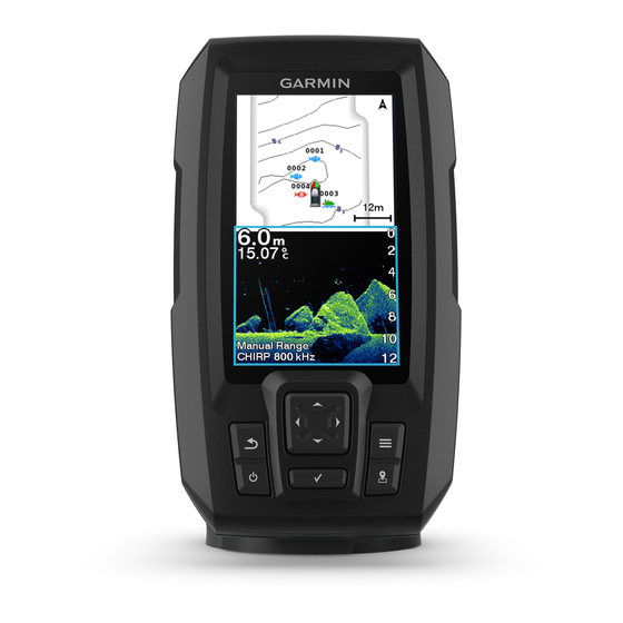
Sonar Enter a name for the combination. TIP: The full screen page, the split frequency page, and the flasher • Select to save. page are visual representations of the area beneath your boat. • Hold to clear data. You can customize these sonar views. •... -
Page 7: Split-Screen Frequency
Select Settings > My Vessel > Transducer Type. Logs Distance from the side of the vessel Select the type of transducer you are using. Water between the vessel and the bottom Creating a Waypoint on the Sonar Screen Split-Screen Frequency Using Your Present Location From a sonar view, select You can view two frequencies from the split frequency screen. -
Page 8: Hiding Surface Noise
Adjusting the Zoom • To display lower-sensitivity sonar returns with less noise automatically, select Auto Low. You can adjust the zoom manually by specifying the span and a fixed starting depth. For example, when the depth is 15 m and Hiding Surface Noise the starting depth is 5 m, the device displays a magnified area You can hide or display the sonar returns near the surface of the... -
Page 9: Showing And Adjusting The Depth Line
Waypoints From a sonar view, select > Sonar Setup > Scroll Speed. Waypoints are locations you record and store in the device. Select an option: • To adjust the scroll speed automatically using speed-over- Marking Your Present Location as a ground, select Auto. -
Page 10: Routes
Routes Deleting All Saved Routes Select User Data > Manage Data > Clear User Data > A route is a sequence of waypoints or locations that leads you to Routes. your final destination. Creating and Navigating a Route Using the Track Waypoint Map A track is a recording of the current path of your boat. -
Page 11: System Information
Turn Transition Activ.: Sets the turn transition to be calculated and the software version. based on time or distance. Garmin Devices: Provides information about connected Garmin Turn Transition Time: Sets how many minutes before the turn devices. that you transition to it as the next leg, when Time is selected Factory Settings: Restores the device to factory settings. -
Page 12: Setting The Keel Offset
Title, ownership rights, and intellectual property number to display depth below keel. rights in and to the Software remain in Garmin and/or its third- • If the transducer is installed at the bottom of the keel party providers. -
Page 13: My Sonar Does Not Work
To check the voltage, measure the female power and ground sockets of the power cable for DC voltage. If the voltage is less than 10 Vdc, the device will not turn on. My sonar does not work • Push the transducer cable all the way into the back of the device. -
Page 14: Index
Index safe height 7 satellite signals, acquiring 1 screen, brightness 1 settings 1, 2, 6, 7 alarms 7 system information 6 anchor drag 7 SideVü 2 arrival 7 software license agreement 8 navigation 7 sonar 2, 3 course 7 a-scope 5 sonar 7 alarms 7 anchor drag alarm 7 appearance 2 arrival alarm 7 bottom lock 4 depth line 5 depth scale 2, 4 backlight 1 DownVü 2... - Page 16 +34 93 275 44 97 +27 (0)11 251 9800 + 46 7744 52020 +886 2 2642-9199 ext 2 +49 (0) 89 858364880 0808 238 0000 zum Ortstarif - Mobilfunk +44 870 850 1242 kann abweichen 913-397-8200 1-800-800-1020 © 2015 Garmin Ltd. or its subsidiaries...
Need help?
Do you have a question about the STRIKER Series and is the answer not in the manual?
Questions and answers