Garmin C330 Facilitator Manual
Garmin c330 personal navigation system
Hide thumbs
Also See for C330:
- Owner's manual (42 pages) ,
- Setup manual (9 pages) ,
- User manual (9 pages)

Related Manuals for Garmin C330


Summary of Contents for Garmin C330
- Page 1 Personal Navigation System: Garmin C330 Garmin C330 Personal Navigation System Facilitator Guide Matthew Kimball – Retail Sales Trainer - Simulation Exercise Garmin C330 FG (PANEL)v1.0 1 of 16...
- Page 2 Personal Navigation System: Garmin C330 Icon Legend The Facilitator is presenting an idea/concept and describing how/why it is. By definition, it would be one-sided, with only intermittent interruptions (ex. - a participant may ask for a clarification, or refute a point) ...
- Page 3 Personal Navigation System: Garmin C330 Trainer Information Training Materials Checklist Facilitator Guide Participant Guide (Including Job Aid, Owners Manual and Quick Ref. Aid) Easel Chart Easel Markers Sign‐in Sheet Name Tents Pens/Pencils Sticky Notes Evaluation Form Optional Materials Checklist Projector Projector Screen / White Board Pre‐ Class Organization and setup Handout the following materials prior to class beginning: Participants Guide Garmin C330 Owners Manual Job Aid (you may want to hold back, depending on time allotment) 4 sticky notes for each participant Trainer Tip: To facilitate the class in a much shorter period of time, you may choose to easel chart some of the material before class, using a second easel chart for class participation. Trainer Tip: This class has been designed with a PowerPoint presentation. This is entirely optional up to the trainer as to its use. Matthew Kimball – Retail Sales Trainer - Simulation Exercise Garmin C330 FG (PANEL)v1.0...
- Page 4 Personal Navigation System: Garmin C330 Module 1 – Introductions and Objectives (30 minutes) Part 1 – Introductions (15 minutes) Show: (OPTIONAL) PPT slide 1 <OR> PPT1 Easel Chart: Welcome to Personal Navigation System Training Explain: Trainer will welcome the group Personal Navigation System Training. Facilitator introduces themselves to group: tenure w/ Training Organization, employment background, experience as a trainer, contact info Show: (OPTIONAL) PPT slide 2 PPT2 ...
- Page 5 Personal Navigation System: Garmin C330 Part 2 – Objectives (15 minutes) Explain objectives and agenda for Garmin C330 Training PPG 2 The associates will: 1. Identify the features of the Garmin C330 2. List and explain the advantages of the Garmin C330. Recognize and overcome customer objections or apprehensions by being able to identify the specific benefits of you’re individual customer. Show: (OPTIONAL) PPT slide 3 PPT3 WIIFM Ask: What do you hope to gain from this training? (Have participants write answers in their PG) Show: (OPTIONAL) PPT slide 4 PPT4 Listen For: Increased sales, more satisfied and educated customers and clients ...
- Page 6 Personal Navigation System: Garmin C330 Module 2 – Features, Advantages & Benefits (15 minutes) Part 1 – Features (5 Minutes) Ask: associates to volunteer reading the next 4 paragraphs PPG2 after you read the first: Explain: The Purchase of a Portable Navigation System (PNS) to meet your client’s needs may not be as simple as one might think. There are a myriad of different devices, for many different purposes. The first thing to consider when buying a PNS device is its primary use. Will your customer be using it on the road, on the trail, or on the water? On the road, devices are usually temporarily mounted in the vehicle with suction cups or bean bags. Most of these devices have turn‐by‐turn instructions and auto correction if you miss a turn. I like to recommend a device with an auto‐correction feature, that way our customers don't have to deal with ...
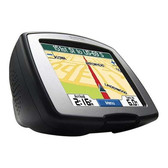
- Page 7 Personal Navigation System: Garmin C330 Show: (OPTIONAL) PPT slide 5 PPT5 • Unit dimensions: 4.4” W x 3.2” H x 2.8” D • Display: 2.8” W x 2.1” H (3.5” diag.), 320 x 240 pixels; transflective TFT, 64K colors; bright white LED backlight and touch screen • Weight: 9.45 ounces • Preloaded maps for all of North America or Europe • Fingertip touchscreen interface • Look up addresses and points of interest (POIs) • Choose 2D or 3D map perspective • Upload custom POIs (points of interest), including alerts for speed zones and safety cams • Turn‐by‐turn voice prompted directions, menus and text • SD memory card expansion slot •...
- Page 8 Personal Navigation System: Garmin C330 Part 2 – Advantages (5 Minutes) Activity: Have associates complete matching activity PPG3 Facilitator: debrief activity, reviewing handout Feature: Advantage: 1) Receiver WAAS‐enables 12 D) a system of satellites and parallel channel GPS ground stations that provide GPS signal corrections, giving you even better position accuracy 2) Look up addresses and points B) Pre‐loaded of interest (POIs) 3) SD memory card expansion A) Addition of other Maps slot 4) Rechargeable lithium‐ion ...
- Page 9 Personal Navigation System: Garmin C330 Part 3 – Benefits (5 Minutes) Explain: We’ve discussed the features and advantages of PPG4 the C330, were now going to turn to PPG4 and look at the benefits Have: participants write answers in PG to the following questions: ASK: What is the difference between a feature and a benefit? Listen For: A Feature: is a characteristic or capability of a product A Benefit: is what the feature will do for a specific customer Show: (OPTIONAL) PPT slide 7 PPT7 Ask: I’m going to give you about 3 minutes to complete some of the benefits to the C330? ...
- Page 10 Personal Navigation System: Garmin C330 update the system map database and import third‐ party data information from your Personal Computer Module 3 – Summary (20 Minutes) Part 1 – Tips (5 Minutes) ASK: What tips can you provide or will help others sell the C330? • Pull and Play availability – no technical jargon or hard to understand manuals to read! • easier navigation in an unknown area • internal power supply makes this great for the adventurer, your no longer tethered to your vehicle • Providing a sense of security • less time spent searching for desired points of interest, addresses Easel Chart: Responses & Answers Add any additional Tips Such as: • Fast, Affordable & Reliable • Always know where you are ...
- Page 11 Personal Navigation System: Garmin C330 Handout: Garmin StreetPilot C330 Job Aid Part 3 – Question and Answer (10 Minutes) Pass four blank sticky notes to each participant. Have participants write the answers to the following questions on four different sticky notes. Once they’ve ACTIVITY answered all four, have them place the notes an easel chart page. Easel page should be divided into sections – one for each question. Show: (OPTIONAL) PPT slide 8 PPT8 Ask: the participants the following questions. What did you like about today’s session? What do you wish had been done differently during today’s session? What surprised you? What do you what to know more about? Discuss: the different answers. Have them answer the questions and write the answers in ...
- Page 12 Casey and Paul Shumaker, that develops consumer and aviation technologies for the Global Positioning System. Subsidiary Garmin International, Inc. serves as headquarters for the Garmin Limited companies and is located in Olathe, Kansas, which is located in the Kansas City Metropolitan Area. The largest operating subsidiary and primary production facility of Garmin Limited is Garmin (Asia) Corporation located in Sijhih City, Taiwan, a suburb of Taipei.
- Page 13 Another early product, a handheld GPS receiver, proved popular with military personnel serving in Kuwait and Saudi Arabia during the 1991 Gulf War. In the early 2000s, Garmin launched a series of personal GPS devices aimed at recreational runners called the Forerunner, and also launched their popular StreetPilot in-car navigation series, starting with a monochrome key-operated unit.
- Page 14 300 series. The 660 added bluetooth, FM transmitter, enhanced screen brightness and screen size, all in a small "flat" size. One of the Most Poular of the Garmin GPS units are the Etrex series. These GPS units are colorful with features that differentiate with each unit.
- Page 15 University of Tennessee. The same year Forbes estimated Burrell’s net worth as $940 million. In 2006, Garmin announced it would release all of its software for Mac OS X by the end of the year. Garmin has begun to rollout a new corporate logo. That same year, the company announced the opening of its first retail store on Michigan Avenue in Chicago, Illinois.
-
Page 16: What Is Waas
Personal Navigation System: Garmin C330 What is WAAS: You've heard the term WAAS, seen it on packaging and ads for Garmin® products, and maybe even know it stands for Wide Area Augmentation System. Okay, so what the heck is it? Basically, it's a system of satellites and ground stations that provide GPS signal corrections, giving you even better position accuracy. How much better? Try an average of up to five times better. A WAAS‐capable receiver can give you a position accuracy of better than three meters 95 percent of the time. And you don't have to purchase additional receiving equipment or pay service fees to utilize WAAS. The origins of WAAS The Federal Aviation Administration (FAA) and the Department of Transportation (DOT) are developing the WAAS program for use in precision flight approaches. Currently, GPS alone does not meet the FAA's navigation requirements for accuracy, integrity, and availability. WAAS corrects for GPS signal errors caused by ionospheric disturbances, timing, and satellite orbit errors, and it provides vital integrity information regarding the health of each GPS satellite. How it Works WAAS consists of approximately 25 ground reference stations positioned across the United States that monitor GPS satellite data. Two master stations, located on either coast, collect data from the reference stations and create a GPS correction message. This correction accounts for GPS satellite orbit and clock drift plus signal delays caused by the atmosphere and ionosphere. The corrected differential message is then broadcast through one of two geostationary satellites, or satellites with a fixed position over the equator. The information is compatible with the basic GPS signal structure, which means any WAAS‐ enabled GPS receiver can read the signal. Who benefits from WAAS? Currently, WAAS satellite coverage is only available in North America. There are no ground reference stations in South America, so even though GPS users there can receive WAAS, the signal has not been corrected and thus would not improve the accuracy of their unit. For some users in the U.S., the position of the satellites over the equator makes it difficult to receive the signals when trees or mountains obstruct the view of the horizon. WAAS signal reception is ideal for open land and marine applications. WAAS provides extended coverage both inland and offshore compared to the land‐based DGPS (differential GPS) system. Another benefit of WAAS is that it does not require additional receiving equipment, while DGPS does. ...
Need help?
Do you have a question about the C330 and is the answer not in the manual?
Questions and answers