Table of Contents
Advertisement
Quick Links
Globalsat Technology Corporation
16F., No. 186, Jian-Yi Road, Chung-Ho City, Taipei Hsien 235, Taiwan
Tel: 886-2-8226-3799/ Fax: 886-2-8226-3899
service@globalsat.com.tw
www.globalsat.com.tw
EM-406a
GPS Engine Board
EM-406a
Page 1 of 13
USGlobalSat, Inc.
14740 Yorba Court, Chino, CA 91710
Tel: 909.597.8525 / Fax: 909.597.8532
oem@usglobalsat.com
www.usglobalsat.com
Specifications are subject to be changed without notice.
Version 1.4.1
Advertisement
Table of Contents

Related Manuals for Globalsat EM-406a


Summary of Contents for Globalsat EM-406a
- Page 1 EM-406a Version 1.4.1 GPS Engine Board EM-406a Globalsat Technology Corporation USGlobalSat, Inc. 16F., No. 186, Jian-Yi Road, Chung-Ho City, Taipei Hsien 235, Taiwan 14740 Yorba Court, Chino, CA 91710 Tel: 886-2-8226-3799/ Fax: 886-2-8226-3899 Tel: 909.597.8525 / Fax: 909.597.8532 service@globalsat.com.tw oem@usglobalsat.com www.globalsat.com.tw...
-
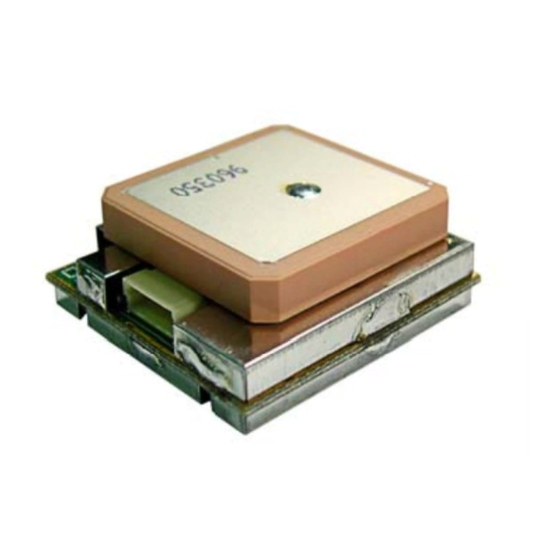
Page 2: Product Information
Product Part I.D. EM-406a Product Description The EM-406a GPS engine board is low cost but maintains high reliability and accuracy making it an ideal choice for integration with OEM/ODM systems. The EM-406a features an integrated patch antenna for complete implementation. - Page 3 Humidity Range 5% to 95% non-condensing Operation Temperature -40F to +176F (-40C to 85C) Differences between the EM-406 and EM-406a: a.) RoHS lead-free b.) 1 PPS added to pin #6 Specifications are subject to be changed without notice. Page 3 of 13...
-
Page 4: Technical Information
EM-406a Version 1.4.1 2. Technical Information Physical Characteristics Digi-Key Crimp Pin #455-1561-1-ND (part number #455-1561-2-ND is the tape & reel format) Specifications are subject to be changed without notice. Page 4 of 13... -
Page 5: Pin Assignment
EM-406a Version 1.4.1 Pin Assignment Pin Explanation VCC (DC power input): This is the main DC supply for a 4.5V ~ 6.5V power module board. This is the main transmit channel for outputting navigation and measurement data to user’s navigation software or user-written software. - Page 6 EM-406a Version 1.4.1 UTC Time 161229.487 hhmmss.sss Latitude 3723.2475 ddmm.mmmm N/S Indicator N=north or S=south Longitude 12158.3416 dddmm.mmmm E/W Indicator E=east or W=west Position Fix Indicator See Table B-3 Satellites Used Range 0 to 12 HDOP Horizontal Dilution of Precision...
- Page 7 EM-406a Version 1.4.1 GSA-GNSS DOP and Active Satellites Table B-5 contains the values for the following example: $GPGSA,A,3,07,02,26,27,09,04,15,,,,,,1.8,1.0,1.5*33 Table B-5 GSA Data Format Name Example Units Description Message ID $GPGSA GSA protocol header Mode1 See Table B-6 Mode2 See Table B-7...
- Page 8 EM-406a Version 1.4.1 Number of Messages Range 1 to 3 Message Number Range 1 to 3 Satellites in View Satellite ID Channel 1(Range 1 to 32) Elevation degrees Channel 1(Maximum90) Azimuth degrees Channel 1(True, Range 0 to 35 SNR(C/No) dBHz Range 0 to 99,null when not tra …….
- Page 9 EM-406a Version 1.4.1 Name Example Units Description Message ID $GPVTG VTG protocol header Course 309.62 degrees Measured heading Reference True Course degrees Measured heading Reference Magnetic Speed 0.13 knots Measured horizontal speed Units Knots Speed Km/hr Measured horizontal speed Units...
- Page 10 EM-406a Version 1.4.1 (in X, Y, Z coordinates), clock offset, and time. This action enables the GPS receiver to search for the necessary satellite signals at the correct signal parameters. The newly acquired and stored satellite data will enable the receiver to acquire signals more quickly, and thus, generate a rapid navigational solution.
- Page 11 EM-406a Version 1.4.1 parameters are stored in a battery backed SRAM. Resulting, GPS receiver using the saved Parameters for restart. Format: $PSRF102,<Baud>,<DataBits>,<StopBits>,<Parity>*CKSUM<CR><LF> <baud> 1200,2400,4800,9600,19200,38400 <DataBits> <StopBits> <Parity> 0=None,Odd=1,Even=2 Example: Set DGPS Port to be 9600,8,N,1 $PSRF102,9600,8,1.0*12 D.) Query/Rate Control ID:103 Query standard NMEA message and/or set output rate This command is used to control standard NMEA data output messages: GGA, GLL, GSA, GSV, RMC, and VTG.
- Page 12 EM-406a Version 1.4.1 Format: $PSRF104,<Lat>,<Lon>,<Alt>,<ClkOffset>,<TimeOfWeek>,<WeekNo>, <ChannelCount>, <ResetCfg>*CKSUM<CR><LF> <Lat> Latitude position, assumed positive north of equator and negative south of equator float, possibly signed <Lon> Longitude position, it is assumed positive east of Greenwich and negative west of Greenwich Float, possibly signed <Alt>...
-
Page 13: Units Description
EM-406a Version 1.4.1 G). Select Datum ID:106 Selection of datum to be used for coordinate transformations GPS receivers perform initial position and velocity calculations using an earth-centered earth-fixed (ECEF) coordinate system. Results may be converted to an earth model (geoid) defined by the selected datum.
Need help?
Do you have a question about the EM-406a and is the answer not in the manual?
Questions and answers