
Related Manuals for Sokkia CX-65


Summarization of Contents
HOW TO READ THIS MANUAL
Symbols
Explains symbols used for warnings, notes, and prohibitions.
CX FUNCTIONS
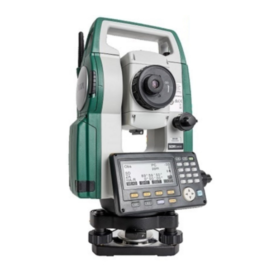
Parts of the Instrument
Identifies and labels all physical components of the CX series instrument.
Mode Diagram
Visual representation of the instrument's operational modes and transitions.
Bluetooth Wireless Technology
Details on using the instrument's Bluetooth capabilities and potential interferences.
BASIC OPERATION
Basic Key Operation
Details the fundamental operations of the instrument's keys and buttons.
Display Functions
Explains various screen modes and their displayed information.
Star Key Mode
Accesses a shortcut menu for common measuring settings.
USING THE BATTERY
Battery Charging
Step-by-step procedure for charging the instrument's battery.
CONNECTING TO EXTERNAL DEVICES
Necessary settings for Bluetooth communication
Outlines the essential settings for establishing Bluetooth connectivity.
Establishing a connection between the CX and paired Bluetooth device
Procedure for connecting the CX to a Bluetooth companion device.
ANGLE MEASUREMENT
Measuring the Horizontal Angle between Two Points
How to measure the angle between two points, setting the horizontal angle to 0.
DISTANCE MEASUREMENT
Returned Signal Checking
Method to check the strength of the returned signal for accurate distance measurement.
Distance and Angle Measurement
Procedure for performing simultaneous distance and angle measurements.
SETTING INSTRUMENT STATION
Entering Instrument Station Data and Azimuth Angle
Details on inputting station coordinates, heights, and azimuth for measurements.
Setting Instrument Station Coordinate with resection measurement
How to determine station coordinates by measuring known points.
SETTING-OUT MEASUREMENT
Coordinates Setting-out Measurement
How to set out points using coordinate data.
SETTING-OUT LINE
Defining Baseline
Steps to define a baseline by inputting or observing two points.
SETTING-OUT ARC
Defining an Arc
Methods for defining an arc using parameters or observations.
POINT PROJECTION
Defining Baseline
Steps for defining a baseline for point projection.
TOPOGRAPHY OBSERVATION
Observation Setting
Configuration options before starting topography observation.
OFFSET MEASUREMENT
Single-distance Offset Measurement
Procedure for measuring an offset point using one distance.
Two-distance Offset Measurement
Procedure for measuring an offset point using two distances.
MISSING LINE MEASUREMENT
Measuring the Distance between 2 or more Points
How to measure distances between multiple points using observation.
ROUTE SURVEYING
Straight Line Calculation
Calculating coordinates for straight line features.
Circular Curve Calculation
Calculating coordinates for circular curves.
Spiral Curve
Calculating coordinates for spiral (clothoid) curves.
Parabola
Calculating coordinates for parabolic curves.
3 Point Calculation
Calculating curve parameters using three points.
Intersection Angle/Azimuth Angle Calculation
Calculating intersection or azimuth angles based on points.
Route Calculation
Overall process for calculating cardinal and width pegs for routes.
RECORDING DATA - TOPO MENU -
Recording Instrument Station Data
How to store instrument station coordinates and related parameters.
Recording Backsight Point
Procedure for recording backsight station data and azimuth.
Recording Distance Measurement Data
Steps to store measured distance data.
Recording Coordinate Data
Procedure for storing measured coordinate data.
SELECTING/DELETING A JOB
Selecting a JOB
Steps to choose the active JOB and coordinate search JOB.
REGISTERING/DELETING DATA
Registering/Deleting Known Point Data
Adding or removing known point coordinate data.
OUTPUTTING JOB DATA
Outputting JOB Data to Host Computer
Steps to export JOB data via serial or USB connection.
USING USB MEMORY DEVICE
Inserting the USB Memory Device
How to physically connect and insert the USB memory device.
Storing JOB Data to USB Memory device
Procedure to save JOB data onto a USB memory device.
CHANGING THE SETTINGS
Configuration -Config Mode-
Detailed explanation of various observation and instrument configuration settings.
EDM Settings
Settings related to the Electronic Distance Measurement functionality.
Allocating Key Functions
Customizing softkey assignments for efficient operation.
CHECKS AND ADJUSTMENTS
Circular Level
Checking and adjusting the circular level for proper instrument leveling.
Tilt Sensor
Checking and calibrating the tilt sensor for angle compensation.
Collimation
Measuring and correcting collimation error for accurate angle measurements.
Optical Plummet
Checking and adjusting the optical plummet for accurate centering.
STANDARD EQUIPMENT AND OPTIONAL ACCESSORIES
Standard equipment
Lists the items that come standard with the instrument.
Optional accessories
Lists additional accessories sold separately for enhanced functionality.
EXPLANATION
Manually Indexing the Vertical Circle by Face 1/2 Measurement
Procedure for manually calibrating the vertical circle index.
Need help?
Do you have a question about the CX-65 and is the answer not in the manual?
Questions and answers