Sign In
Upload
Download
Table of Contents
Contents
Add to my manuals
Delete from my manuals
Share
URL of this page:
HTML Link:
Bookmark this page
Add
Manual will be automatically added to "My Manuals"
Print this page
×
Bookmark added
×
Added to my manuals
Manuals
Brands
Garmin Manuals
GPS
GPSMAP1222
Owner's manual
Garmin GPSMAP1222 Owner's Manual
Hide thumbs
1
2
Table Of Contents
3
4
5
6
7
8
9
10
11
12
13
14
15
16
17
18
19
20
21
22
23
24
25
26
27
28
29
30
31
32
33
34
35
36
37
38
39
40
41
42
43
44
45
46
47
48
49
50
51
52
53
54
55
56
57
58
59
60
61
62
63
64
65
66
67
68
69
70
71
72
73
74
75
76
77
78
79
80
81
82
83
84
85
86
87
88
89
90
91
92
93
94
95
96
97
98
99
100
101
102
103
104
105
106
107
108
109
110
111
112
113
114
115
116
117
118
119
120
121
122
123
124
125
126
127
128
129
130
131
132
133
134
135
136
137
138
139
140
141
142
143
144
145
146
147
148
149
150
151
152
153
154
155
156
157
158
159
160
161
162
163
164
165
166
167
168
169
170
171
172
173
174
175
176
177
178
179
180
181
182
183
184
185
186
187
188
189
190
191
192
193
194
195
196
197
198
199
200
201
202
203
204
205
206
207
208
209
210
211
212
213
214
page
of
214
Go
/
214
Contents
Table of Contents
Troubleshooting
Bookmarks
Table of Contents
Table of Contents
Introduction
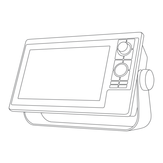
Device Overview
Keys
Connector View
Tips and Shortcuts
Accessing Owner's Manuals on the Chartplotter
Accessing the Manuals from the Web
Garmin Support Center
Inserting Memory Cards
Acquiring GPS Satellite Signals
Selecting the GPS Source
Customizing the Chartplotter
Home Screen
Pinning a Feature Button
Rearranging the Category Items
Assigning a Shortcut Key
Setting the Vessel Type
Adjusting the Backlight
Adjusting the Color Mode
Adjusting the Color Theme
Enabling Screen Lock
Turning on the Chartplotter Automatically
Automatically Turning off the System
Customizing Pages
Customizing the Startup Screen
Recommended Startup Image Dimensions
Creating a New Combination Page
Adding a Smartmode Layout
Customizing the Layout of a Smartmode or Combination Page
Deleting a Combination Page
Customizing the Data Overlays
Resetting the Station Layouts
Presets
Managing Presets
Saving a New Preset
Controlling the Chartplotter
Voice Control
Changing the Voice Control Language
Supported Headsets
Pairing a Wireless Headset with a Garmin Chartplotter
Using a Wireless Headset with a Garmin Chartplotter
Chartplotter Voice Commands
GRID Remote Control
Pairing the GRID Device with the Chartplotter from the Chartplotter
Pairing the GRID Device with the Chartplotter from the GRID Device
Rotating the GRID Remote Input Device
Activecaptain® App
Activecaptain and Garmin Bluenet Considerations
Activecaptain Roles
Getting Started with the Activecaptain App
Enabling Smart Notifications
Receiving Notifications
Managing Notifications
Making Notifications Private
Updating Software with the Activecaptain App
Updating Charts with Activecaptain
Chart Subscriptions
Communication with Wireless Devices
Wi-Fi Network
Setting up the Wi-Fi Network
Connecting a Wireless Device to the Chartplotter
Changing the Wireless Channel
Changing the Wi-Fi Host
Wireless Remote Control
Pairing the Wireless Remote Control with the Chartplotter
Turning on and off the Remote Backlight
Disconnecting the Remote Control from All Chartplotters
Wireless Wind Sensor
Connecting a Wireless Sensor to the Chartplotter
Adjusting the Wind Sensor Orientation
Viewing Boat Data on a Garmin Watch
Viewing Boat Data on a Garmin Nautix™ Device
Charts and 3D Chart Views
Detailed Charts
Activating a Marine Chart Subscription
Purchasing a Chart Subscription with Activecaptain
Renewing Your Subscription
Navigation Chart and Fishing Chart
Chart Symbols
Zooming in and out of the Chart
Panning the Chart with the Keys
Selecting an Item on the Map Using the Device Keys
Measuring a Distance on the Chart
Creating a Waypoint on the Chart
Viewing Location and Object Information on a Chart
Viewing Details about Navaids
Navigating to a Point on the Chart
Premium Chart Features
Fish Eye 3D Chart View
Viewing Tide Station Information
Animated Tide and Current Indicators
Showing Tides and Current Indicators
Showing Satellite Imagery on the Navigation Chart
Viewing Aerial Photos of Landmarks
Automatic Identification System
AIS Targeting Symbols
Heading and Projected Course of Activated AIS Targets
Viewing a List of AIS Threats
Activating a Target for an AIS Vessel
Deactivating a Target for an AIS Vessel
Viewing Information about a Targeted AIS Vessel
Showing AIS Vessels on a Chart or 3D Chart View
Setting the Safe-Zone Collision Alarm
AIS Aids to Navigation
AIS Distress Signals
Turning off AIS Reception
Chart Menu
Chart Layers
Chart Layer Settings
Depth Layer Settings
Laylines Settings
My Vessel Layer Settings
Other Vessels Layer Settings
User Data Layer Settings
Water Layer Settings
Depth Range Shading
Weather Layer Settings
Radar Overlay Settings
Chart Settings
Fish Eye 3D Settings
Supported Maps
Garmin Quickdraw Contours Mapping
Mapping a Body of Water Using the Garmin Quickdraw Contours Feature
Adding a Label to a Garmin Quickdraw Contours Map
Garmin Quickdraw Community
Connecting to the Garmin Quickdraw Community with Activecaptain
Downloading Garmin Quickdraw Community Maps Using Activecaptain
Sharing Your Garmin Quickdraw Contours Maps with the Garmin Quickdraw Community Using Activecaptain
Connecting to the Garmin Quickdraw Community with Garmin Connect
Downloading Garmin Quickdraw Community Maps Using Garmin Connect
Quickdraw Community Using Garmin Connect
Sharing Your Garmin Quickdraw Contours Maps with the Garmin
Garmin Quickdraw Contours Settings
Navigation with a Chartplotter
Basic Navigation Questions
Route Color Coding
Destinations
Searching for a Destination by Name
Selecting a Destination Using the Navigation Chart
Searching for a Marine Services Destination
Setting and Following a Direct Course Using Go to
Stopping Navigation
Waypoints
Marking Your Present Location as a Waypoint
Creating a Waypoint at a Different Location
Marking a man Overboard or Other SOS Location
Projecting a Waypoint
Viewing a List of All Waypoints
Editing a Saved Waypoint
Moving a Saved Waypoint
Browsing for and Navigating to a Saved Waypoint
Deleting a Waypoint or an MOB
Deleting All Waypoints
Routes
Creating and Navigating a Route from Your Present Location
Creating and Saving a Route
Viewing a List of Routes and Auto Guidance Paths
Editing a Saved Route
Finding and Navigating a Saved Route
Browsing for and Navigating Parallel to a Saved Route
Initiating a Search Pattern
Deleting a Saved Route
Deleting All Saved Routes
Auto Guidance
Setting and Following an Auto Guidance Path
Creating and Saving an Auto Guidance Path
Adjusting a Saved Auto Guidance Path
Canceling an Auto Guidance Calculation in Progress
Setting a Timed Arrival
Auto Guidance Path Configurations
Adjusting the Distance from Shore
Tracks
Showing Tracks
Setting the Color of the Active Track
Saving the Active Track
Viewing a List of Saved Tracks
Editing a Saved Track
Saving a Track as a Route
Browsing for and Navigating a Recorded Track
Deleting a Saved Track
Deleting All Saved Tracks
Retracing the Active Track
Clearing the Active Track
Managing the Track Log Memory During Recording
Configuring the Recording Interval of the Track Log
Boundaries
Creating a Boundary
Converting a Route to a Boundary
Converting a Track to a Boundary
Editing a Boundary
Linking a Boundary to a Smartmode Layout
Setting a Boundary Alarm
Disabling All Boundary Alarms
Deleting a Boundary
Deleting All Saved Waypoints, Tracks, Routes, and Boundaries
Sailing Features
Setting the Vessel Type for Sailing Features
Sail Racing
Starting Line Guidance
Setting the Starting Line
Using the Starting Line Guidance
Starting the Race Timer
Stopping the Race Timer
Setting the Distance between the Bow and the GPS Antenna
Laylines Settings
Polar Tables
Importing a Polar Table Manually
Showing Polar Data in Data Fields
Setting the Keel Offset
Sailboat Autopilot Operation
Wind Hold
Changing the Wind Hold Type
Adjusting the Wind Hold Angle
Engaging Wind Hold
Engaging Wind Hold from Heading Hold
Tack and Gybe
Setting a Tack Delay
Tacking and Gybing from Heading Hold
Tacking and Gybing from Wind Hold
Enabling the Gybe Inhibitor
Heading Line and Angle Markers
Setting the Heading Line and Angle Markers
Viewing Sailing Vessel Data
Sonar Fishfinder
Stopping the Transmission of Sonar Signals
Traditional Sonar View
Split-Frequency Sonar View
Split-Zoom Sonar View
Garmin Clearvü Sonar View
Garmin Sidevü Sonar View
Sidevü Scanning Technology
Measuring Distance on the Sonar Screen
Panoptix Sonar Views
Livevü down Sonar View
Livevü Forward Sonar View
Realvü 3D Forward Sonar View
Realvü 3D down Sonar View
Realvü 3D Historical Sonar View
Garmin Frontvü Sonar View
Livescope Sonar View
Perspective View
Selecting the Transducer Type
Selecting a Sonar Source
Renaming a Sonar Source
Creating a Waypoint on the Sonar Screen
Pausing the Sonar Display
Viewing Sonar History
Sonar Sharing
Adjusting the Level of Detail
Adjusting the Range, Gain, and Brightness with the Knob
Adjusting the Color Intensity
Sonar Setup
Setting the Zoom Level on the Sonar Screen
Setting the Scroll Speed
Adjusting the Range
Sonar Noise Rejection Settings
Sonar Appearance Settings
Sonar Alarms
Advanced Sonar Settings
Transducer Installation Settings
Sonar Frequencies
Creating a Frequency Preset
Selecting the Transducer Frequency
Turning on the A-Scope
Panoptix Sonar Setup
Adjusting the Realvü Sweep Speed
Livevü Forward and Garmin Frontvü Sonar Settings
Setting the Livevü and Garmin Frontvü Transducer Transmit Angle
Livevü and Garmin Frontvü Appearance Settings
Livevü and Garmin Frontvü Layout Settings
Setting the Garmin Frontvü Depth Alarm
Panoptix Transducer Installation Settings
Realvü Appearance Settings
Calibrating the Compass
Setting the Bow Offset
Livescope and Perspective Sonar Settings
Livescope and Perspective Sonar Setup
Livescope and Perspective Appearance Settings
Livescope and Perspective Layout Settings
Livescope and Perspective Transducer Installation Settings
Radar
Radar Interpretation
Radar Overlay
Radar Overlay and Chart Data Alignment
Transmitting Radar Signals
Stopping the Transmission of Radar Signals
Setting up the Timed Transmit Mode
Enabling and Adjusting a Radar no Transmit Zone
Adjusting the Radar Range
Tips for Selecting a Radar Range
Motionscope Doppler Radar Technology
Enabling a Guard Zone
Defining a Circular Guard Zone
Defining a Partial Guard Zone
Marpa
MARPA Targeting Symbols
Acquiring MARPA Targets Automatically
Removing MARPA Targets Automatically
Assigning a MARPA Tag to an Object
Removing a MARPA Tag from a Targeted Object
Viewing Information about a MARPA-Tagged Object
Viewing a List of AIS Threats
Showing AIS Vessels on the Radar Screen
VRM and EBL
Showing and Adjusting the VRM and the EBL
Measuring the Range and Bearing to a Target Object
Echo Trails
Turning on Echo Trails
Adjusting the Length of the Echo Trails
Clearing the Echo Trails
Radar Settings
Radar Gain
Adjusting Gain on the Radar Screen Automatically
Adjusting Gain on the Radar Screen Manually
Minimizing Nearby Large-Object Interference
Minimizing Side-Lobe Interference on the Radar Screen
Radar Filter Settings
Adjusting Rain Clutter on the Radar Screen
Adjusting Sea Clutter on the Radar Screen
Averaging Multiple Scans on the Radar Screen
Radar Options Menu
Radar Setup Menu
Reducing Cross Talk Clutter on the Radar Screen
Radar Appearance Settings
Radar Installation Settings
Measuring and Setting the Front-Of-Boat Offset
Setting a Custom Park Position
Radar My Vessel Layer Settings
Selecting a Different Radar Source
Advertisement
Quick Links
1
Inserting Memory Cards
Download this manual
GPSMAP
10X2/12X2 SERIES
®
Owner's Manual
Table of
Contents
Previous
Page
Next
Page
1
2
3
4
5
Advertisement
Table of Contents
Need help?
Do you have a question about the GPSMAP1222 and is the answer not in the manual?
Ask a question
Questions and answers
Related Manuals for Garmin GPSMAP1222
Marine GPS System Garmin Astro 220 Owner's Manual & Reference
Garmin gpsmap owner's manual & reference (92 pages)
GPS Garmin Approach G3 North America Important Safety Instructions Manual
Important safety and product information (36 pages)
Watch Garmin FORERUNNER 210 Owner's Manual
Gps-enabled sports watch (28 pages)
Racks & Stands Garmin Forerunner 110 Instructions Manual
Forerunner foretrex bike mount (25 pages)
Fish Finder Garmin GPSMAP 12 2 Series Installation Instructions Manual
(19 pages)
Marine Radio Garmin VHF 11X Series Owner's Manual
(18 pages)
Watch Garmin FORERUNNER 210 Quick Start Manual
Gps-enabled sports watch (13 pages)
Watch Garmin Forerunner 210 Declaration Of Conformity
Declaration of conformity (6 pages)
GPS Garmin GpsMap 12” Common Settings
(3 pages)
GPS Garmin GPSMAP620 Safety Instruction
Garmin gps receiver user manual (2 pages)
GPS Garmin GPSMAP230 Features And Specifications
(2 pages)
GPS Garmin GPSMAP1022 Owner's Manual
(214 pages)
GPS Garmin GPS 20x Technical Specifications
Garmin gps system technical specifications (19 pages)
GPS Garmin GPS 50 Owner's Manual
Garmin gps 50 personal navigator owner's manual (79 pages)
GPS Garmin GPS Manual
Garmin gps field guide (25 pages)
GPS Garmin GPS Beginner's Manual
Garmin gps (9 pages)
This manual is also suitable for:
Gpsmap 12 2 series
Gpsmap 10 2 series
Gpsmap1022
Table of Contents
Save PDF
Print
Rename the bookmark
Delete bookmark?
Delete from my manuals?
Login
Sign In
OR
Sign in with Facebook
Sign in with Google
Upload manual
Upload from disk
Upload from URL


Need help?
Do you have a question about the GPSMAP1222 and is the answer not in the manual?
Questions and answers